Karimi H.A. Universal Navigation on Smartphones
Подождите немного. Документ загружается.

30
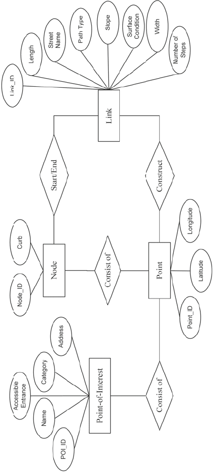
Fig. 2.6 An ER diagram for sidewalk networks in navigation databases
2 Outdoor Navigation

31
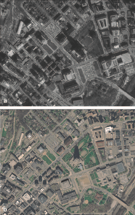
updating road and sidewalk network databases. Figure 2.7 (a)
1
shows an example
of a 1 m resolution satellite image and Figure 2.7 (b)
2
shows an example of a 0.3 m
resolution satellite image for the same area.
Quality of a road network or a sidewalk network is crucial in the operation of an
outdoor navigation system/service as such networks constitute the foundation for
many data processings and computations in navigation systems/services. Due to
availability of various methods for collecting road data and of various techniques
to generate a road network database, different map providers may provide map
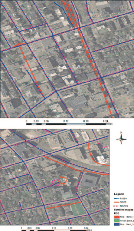
databases with significantly different qualities. Figure 2.8 shows two examples of
road network data, obtained through three different sources (PASDA, TIGER/Line,
and NAVTEQ), overlaid and verified with 0.305 m pixel resolution natural color or-
thoimages obtained from the United States Geological Survey. The accuracy of or-
thoimages is estimated not to exceed 3 m root mean square error (RMSE). TIGER/
Line has the lowest positional accuracy as shown in the figure where some street
centerlines intersect buildings. NAVTEQ has a higher resolution and positional ac-
curacy (e.g., for representation of cul-de-sac features) than the other two sources as
shown on the right image in Figure 2.8.
Table 2.7 shows the different types and sources of uncertainties in road and side-
walk networks. Three general sources of uncertainties are: geometry, topology, and
attribute. Uncertainties associated with geometry in road and sidewalk networks
are of three types: accuracy, completeness, and resolution. Uncertainties associated
with topology in road and sidewalk networks are of two types: accuracy and com-
1
http://www.pasda.psu.edu/uci/MetadataDisplay.aspx?entry=PASDA&file=doq99_
pa.xml&dataset=1
2
http://www.pasda.psu.edu/uci/MetadataDisplay.aspx?entry= PASDA&file=pittsburghpa2005a_
orthoimagery.xml&dataset=603
Table 2.6 Map data providers for road and sidewalk networks
Data Providers Road Network Sidewalk Network Data Collection
Government
Agencies
E.g., U.S. Census
Bureau’s TIGER
Local government
agencies: county,
city
Satellite imagery;
GPS data collection;
Mobile Mapping Systems;
Field survey;
Paper map digitization and
scanning
Non-Profit
Organizations
E.g., Pennsylvania
Spatial Data
Access (PASDA)
Commercial
Mapping
Companies
E.g., NAVTEQ, Tele
Atlas
E.g., NAVTEQ (some
cities), Tele Atlas
(some cities)
Satellite imagery;
GPS data collection;
Mobile Mapping Systems;
Field survey;
Paper map digitization and
scanning
Community
Mapping
Volunteers
E.g., OpenStreetMap,
Wikimapia
E.g., OpenStreetMap
(some areas)
Online GPS data collection;
Online manual map
digitization
2.2 Technologies
32
pleteness. Uncertainties associated with attribute in road and sidewalk networks are
of two types: accuracy and completeness.
In road networks, examples of uncertainties associated with geometry under ac-
curacy type include inaccurate coordinates of nodes (e.g., the represented location
of an intersection is very far from its true location) and inaccurate coordinates of
points representing links (e.g., mismatch between the points forming a road seg-
ment and the true location of the road segment); examples of uncertainties associ-
ated with geometry under completeness type include missing nodes (e.g., an inter-
section is not stored in the database) and missing links (e.g., a road segment is not
stored in the database); an example of uncertainties associated with geometry under
resolution type is insufficient points representing segments (e.g., the small number
of points on a road segment do not represent the true shape of the road segment).
In road networks, an example of uncertainties associated with topology under ac-
curacy type is incorrect connectivity at junctures (e.g., an intersection does not have
Fig. 2.7 Example high-
resolution satellite images.
a 1 m resolution. b 0.3 m
resolution
2 Outdoor Navigation
Openmirrors.comOpenmirrors.com
33
the correct connection to road segments); and an example of uncertainties associ-
ated with topology under completeness type is missing nodes (e.g., an intersection
is not stored in the database).
In road networks, examples of uncertainties associated with attribute under ac-
curacy type are inaccurate name of a road segment, type of a road segment, and
number of lanes in a road segment; examples of uncertainties associated with at-
tribute under completeness type are missing road segment, road segment type, and
number of lanes in a road segment.
In sidewalk networks, an example of uncertainties associated with geometry un-
der accuracy type include inaccurate coordinates of nodes (e.g., a decision point is
located in a wrong place) and inaccurate coordinates of points representing links
Fig. 2.8 Digital road network
data obtained through three
different sources
2.2 Technologies

34
Table 2.7 Types and sources of uncertainties in road and sidewalk networks
Network Geometry Topology Attribute
Accuracy Completeness Resolution Accuracy Completeness Accuracy Completeness
Road Inaccurate coordinates of
nodes (junctures); inac-
curate coordinates of
points representing links
(segments)
Missing nodes (junc-
tures); Missing
links (segments)
Insufficient points
representing
segments
Incorrect
connec-
tivity at
junctures
Missing nodes
(junctures)
Inaccurate
name, type,
number of
lanes
Missing name,
type, number
of lanes
Sidewalk Inaccurate coordinates of
nodes (junctures); inac-
curate coordinates of
points representing links
(segments)
Missing nodes
(junctures); miss-
ing links (e.g.,
footpath)
Insufficient points
representing
segments
Incorrect
connec-
tivity at
junctures
Missing nodes
(junctures)
Inaccurate
name, side,
type
Missing name,
side, type
2 Outdoor Navigation
35
(e.g., the points representing a sidewalk segment do not match the true location of
the sidewalk segment); examples of uncertainties associated with geometry under
completeness type are missing nodes (e.g., a decision point is not stored in the
database) and missing links (e.g., a footpath is not included in the database); an
example of uncertainties associated with geometry under resolution type is insuf-
ficient points representing segments (e.g., the small number of points on a footpath
do not represent the true shape of the footpath).
In sidewalk networks, an example of uncertainties associated with topology un-
der accuracy type is incorrect connectivity at junctures (e.g., a decision point does
not have the correct connection to sidewalk segments); an example of uncertainties
associated with topology under completeness type is missing nodes (e.g., a decision
point is not stored in the database).
In sidewalk networks, examples of uncertainties associated with attribute under
accuracy are inaccurate name of sidewalk segment, side of the road to which side-
walk segment belongs and type of sidewalk segment; examples of uncertainties as-
sociated with attribute under completeness are missing name of sidewalk segment,
side of the road to which sidewalk segment belongs and type of sidewalk segment.
2.3 Functions
An outdoor navigation system/service performs a variety of functions, some are ob-
vious to users and some are performed in the background. Table 2.8 shows the main
functions performed by most outdoor navigation systems/services.
Retrieval. The retrieval function is responsible for retrieval of data from the da-
tabase which contains spatial and attribute data. The input to the retrieval function
is usually a POI name and the output, depending on the input, could be a location of
an intersection or a POI address.
Map creation. The map creation function is responsible for creating a map us-
ing the centroid of an area (e.g., city), a POI location, or current location (obtained
through geo-positioning sensors). This function needs all data including road/side-
walk networks, road/sidewalk segments, and attribute data.
Mapping. Once a map is created, the user is able to perform mapping functions.
The mapping function allows user to zoom in, zoom out, and pan the created map.
Similar to the map creation function, the input to the mapping function could be the
centroid of an area (e.g., city), a POI location, or current location and the output is a
new map. All available data including road/sidewalk networks, road/sidewalk seg-
ments, and attribute data are needed for this function.
Geocoding. The geocoding function is responsible for computing the coordi-
nates of an address or a POI. The input to the geocoding function often is a POI
address and the output is the location of the POI address on the map. The geocoding
process in most cases involves an interpolation scheme whereby spatial information
about the end nodes of road/sidewalk segments (i.e., coordinates of end points),
the geometry of the segment (i.e., series of coordinates forming the shape of the
2.3 Functions

36
Table 2.8 Main functions performed by outdoor navigation systems/services
Computation Input Process Output Database
Retrieval POI name Retrieve spatial, non-spatial data Location of intersection, address of
POI
Spatial, attribute
Map Creation Centroid location, POI location,
current location
Clip spatial and non-spatial data Map Road/sidewalk segments,
attribute
Mapping Centroid location, POI location,
current location
Zoom in, zoom out, pan Map Road/sidewalk segments,
attribute
Geocoding Address Interpolation Location on map Road/sidewalk segments,
attribute
Routing/
Rerouting
Origin-Destination addresses (cur-
rent location for rerouting)
Optimal routing Route on map Road/sidewalk networks
Tracking Position data Map match position data on
road/sidewalk segments
Current location on map Road/sidewalk networks,
road/sidewalk segments,
attribute
Direction Route Compute distance and search for
landmarks
A set of instructions to navigate from
origin (or current location) to
destination
Road/sidewalk networks,
road/sidewalk segments,
attribute
2 Outdoor Navigation
37
segment), and the address ranges on both sides of the segment (i.e., start and end
addresses on each side of the segment) are used to estimate the location of a given
address. The data needed for the geocoding function includes POI address, road/
sidewalk segments, and attribute data.
Geocoding is a common function in outdoor navigation systems/services as well
as other applications and services such as Web Mapping Services (WMSs), e.g.,
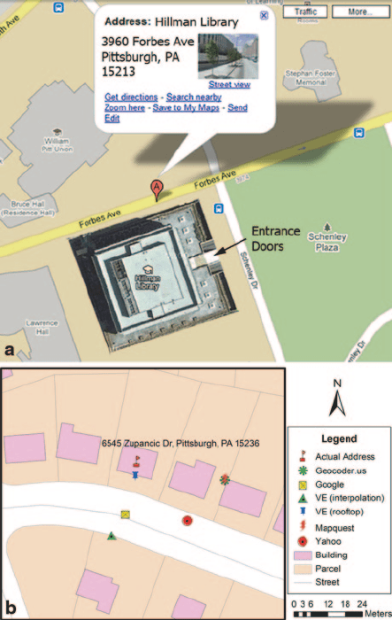
Google Maps, that provide navigation assistance. Results of geocoding by differ-
ent WMSs are illustrated in Figure 2.9. Figure 2.9 (a) shows a geocoded location
from Google’s street geocoding service where the geocoded point is on the side of
the building’s main entrance. Figure 2.9 (b) shows multiple locations of an address
geocoded through different geocoding services.
A reference database upon which a geocoding algorithm geocode addresses,
through interpolation, plays an important role in the process. Street centerlines con-
2.3 Functions
Fig. 2.9
Example geocoding
results by different services.
a Geocoding by Google.
b Geocoding by multiple
services
38
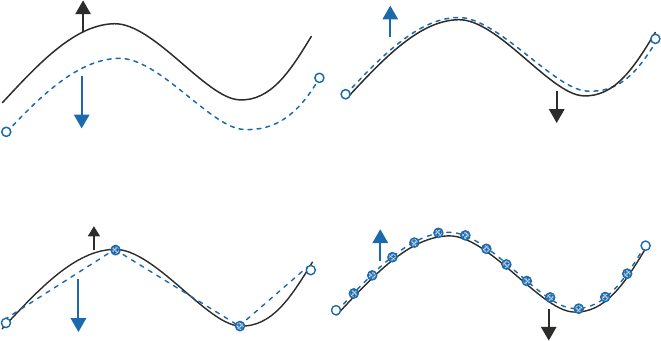
stitute the core of such reference databases. Geometrical accuracy of street center-
lines directly influences positional accuracy of geocoded points since coordinates
along street centerlines are used for calculating street length and interpolating ad-
dresses. Figures 2.10 (a) and (b) illustrate a street centerline with low and high
accuracy, respectively. Street resolution, which is the sampling frequency of shape
points along each segment, is another source of errors. Low-resolution sampling
results in a coarse representation of the actual street and a rough estimate of the total
length of the segment, as shown in Figure 2.10 (c), while high-resolution sampling
results in lines close to actual streets, as shown in Figure 2.10 (d). Low-resolution
reference databases are susceptible to higher errors compared to high-resolution
reference databases.
Geocoding addresses using street information is called street geocoding, which
is the technique in most current geocoding software and tools. An alternative
geocoding technique is called rooftop geocoding where coordinates of centroids
of buildings and monuments are used to geocoded addresses. However, since
rooftop geocoding requires as many centroids as possible in the geographic extent
of interest which are currently unavailable in GIS databases, most existing appli-
cations, including navigation, are based on street geocoding. In general, rooftop
geocoding produces less matched (due to lack of available centroid coordinates
in GIS databases) but more accurate (due to preciseness of centroid coordinates)
results than street geocoding where it produces more matched (due to availability
of street information in GIS databases) but less accurate (due to impreciseness of
information on streets) results.
Fig. 2.10 Example street centerline modeled at different levels of accuracy and resolution.
a Low accuracy b High accuracy c Low resolution d High resolution
Actual street centerline
Modeled street centerline
Actual street centerline
Modeled street centerline
Actual street centerline
Modeled street centerline
Modeled street centerline
a b
c d
Actual street centerline
2 Outdoor Navigation
39
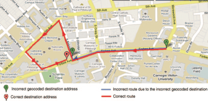
Destinations in navigation systems/services can be obtained through on-the-fly
geocoding or previously geocoded and stored data, thus susceptible to errors due to
uncertainties in geocoding process and map database. Incorrect geocoding, on-the-
fly or stored, results in wrong locations of addresses as destinations and undesired
routes. Figure 2.11 shows two routes, one from origin A to the correct location of
a destination, and another from origin A to an incorrect location of the destination
estimated by geocoding.
Routing/Rerouting. The routing function is responsible for computing optimal
routes, based on a pre-determined criterion, between pairs of origin-destination ad-
dresses. The origin could be entered by the user or current user’s location obtained
through geo-positioning sensors. The output is the computed route highlighted on
the map. The main data needed for the routing function is the road/sidewalk net-
work within the geographic extent of interest (this can be determined by the area
that covers both origin and destination locations) which provides the topology of
the network, a requirement by all routing algorithms. Today’s navigation systems/
services allow different routing criteria such as shortest distance, fastest travel time,
least intersections, and no tolls among others. An extension to the routing function
is rerouting which, depending on the situation (e.g., deviation from the computed
route), re-computes a new route from user’s current location, as the origin, to the
destination.
In general, routes in navigation systems/services could be computed through ex-
act algorithms or heuristic algorithms. Exact algorithms are those algorithms that
consider all possible options between pairs of origin and destination addresses to
find optimal solutions. Heuristic algorithms are those algorithms that are based on
rule-of-thumbs (shortcuts) to find good solutions between pairs of origin and desti-
nation addresses. In other words, exact algorithms consider the entire solution space
(i.e., all possible routes) to find optimal solutions and heuristic algorithms consider
a portion of the solution space (i.e., a subset of all possible routes), to find solutions
2.3 Functions
Fig. 2.11
Two routes from single origin to two different locations
