Middleton W.M. (ed.) Reference Data for Engineers: Radio, Electronics, Computer and Communications
Подождите немного. Документ загружается.

measures are less important than a simpler, lower cost
system.
Automatic Detection and Track
(ADT):
A conven-
tional rotating air-surveillance radar such
as
employed
for air-traffic control obtains an azimuth angle mea-
surement
on
each rotation, or scan,
of
the antenna.
Tracks can be established based on this lower scan rate
(revisit times from 4 to 12
s).
Automatic tracking is
combined with automatic detection and is called auto-
matic detection and track. The data rate is considerably
slower than that of a single-target tracker, but a single
ADT system might be able to hold in track many hun-
dreds or thousands of aircraft targets. Tracking is done
open loop in that the position of the antenna is not con-
trolled by the processed tracking data
as
it is
in
a
closed-loop STT.
Phased Array Radar Tracking:
Multiple targets can
be tracked on a time-shared basis with an agile elec-
tronically steered phased array radar. Tracking is not
closed loop, but it combines the high data rate of
a
STT with the ability of
an
ADT to hold
a
large number
of
targets in track.
Track While Scan
(TWS):
This term has been
applied
to
both the ADT and to
a
radar which rapidly
scans
a
limited angular sector to maintain tracks with
a
moderate data rate on a modest number of targets.
TWS is now almost always applied to the latter mean-
ing rather than to an ADT system. Angle information
can be obtained in
a
TWS radar by using two scanning
fan beams perpendicular to each other, one for the azi-
muth angle measurement and the other for the eleva-
tion angle measurement. A TWS radar can also be
obtained with a single cluster of four monopulse
beams scanning in a raster fashion to provide the
required volume coverage.
REFERENCES
1. Skolnik, M.
I.
Introduction to Radar Systems,
Chapter 2,3rd ed. New York: McGraw-Hill Book
2. Swerling,
P.
“Probability of Detection for Fluctu-
co., 2001.
ating Targets.”
IRE Trans.
IT-6 (April 1960), pp.
269-308.
3.
Marcum,
J.
I.
“A Statistical Theory of Target
Detection by Pulsed Radar, Mathematical Appen-
dix.”
IRE Trans.
IT-6
(April 1960), pp. 145-267.
4. Meyer, D.
P.,
and Mayer, H. A.
Radar Target
Detection.
New York: Academic Press, Inc., 1973.
5.
Blake, L.
V.
“Prediction
of
Radar Range.” Chap-
ter
2
of
Radar Handbook,
2nd ed. Edited by
M.
I.
Skolnik. New York: McGraw-Hill Book Co.,
1990.
6. Blake, L. V.
Radar Range-Performance Analyses.
Lexington, MA: Lexington Books, 1980.
7. Barton, D.
K.,
and Barton,
W.
F.
Modern Radar
System Analysis Software and User’s Manual:
Version
2.0.
Norwood,
MA:
Artech House, 1993.
8.
Knott, E.
E
“Radar Cross Section.” Chapter 11 of
Radar Handbook,
2nd ed. Edited by
M.
I.
Skolnik. New York: McGraw-Hill Book Co.,
1990.
9. Hansen. R. C. “Aperture Theory.” Chapter 1 of
Microwave Scanning Antennas,
Vol.
I.
Edited by
R. Hansen. New York: Academic Press, Inc. 1964.
10. White,
W.
D.
Desirable Illuminations for Circu-
lar Aperture Arrays.
Research Paper P-351,
December 1967. Arlington,
VA:
Institute for
Defense Analyses. (Approved for public release,
but not generally available.)
11.
Stutzman, W.
L.
“Estimating Directivity and Gain
of Antennas,”
IEEE Antennas and Propagation
Magazine
40 (August 1998), pp. 7-1 1.
12. Ruze,
J.
“Antenna Tolerance Theory-A
Review.”
Proc.
IEEE
54 (April 1966),
pp.
633-
640.
13. Cheston, T. C., and Frank,
J.
“Array Antennas.”
Chapter 7
of
Radar Handbook,
2nd ed. Edited by
M.
I.
Skolnik. New York: McGraw-Hill Co.,
1990.
14. Barlow, E.
J.
“Doppler Radar.”
Proc. IRE.
37
(April 1949), pp. 340-355.
15. Shrader, W. W., and Gregers-Hansen, V. “MTI
Radar.” Chapter
15
of
Radar Handbook,
2nd ed.
Edited by M.
I.
Skolnik. New York: McGraw-Hill
Book Co., 1990.
16. Billingsley,
J.
B.
Low
Angle Radar Land Clutter.
Norwich, NY William Andrew Publishing, 2001.
17. Nathanson, F. E.
Radar Design Principles.
2nd
ed. NewYork: McGraw-Hill Book Co., 1991.
37
Radio Navigation
Systems
Revised
by
D.
G.
Jablonski
Introduction
3
7-2
Major Navigation Agencies
Propagation
37-2
Issues
Pulse Transmission
Space Diversity
Frequency Diversity
Radio Navigation Systems
37-3
Omega
Loran-C
Radio Beacons
VOR
(VHF
Omnidirectional Range)
ILS (Instrument Landing System)
DME (Distance Measuring Equipment)
TACAN (Tactical Air Navigation)
MLS (Microwave Landing System)
ATCRBS (Air Traffic Control Radar Beacon System)
Transit
TCAS (Traffic Alert and Collision Avoidance Systems)
NAVSTAR/Global Positioning System
Differential GPS
Future Trends
37-1
37-2
REFERENCE DATA FOR ENGINEERS
INTRODUCTION
Electromagnetic waves at radio and microwave fre-
quencies can be used for the precise measurement of
time, distance, and direction. Several factors make this
possible. First, one can generate extremely accurate
timing signals using a variety of techniques, including
atomic clocks. In addition, radio and microwave sig-
nals can be generated coherently,
so
that their fre-
quency and phase are well controlled and easily
measured. Because of the low ambient thermal noise at
these frequencies, radio signals can be detected at
extraordinarily low power levels
(-
-160
dBW using
time integration techniques).
In
addition, the diverse
propagation characteristics of radio waves, as a func-
tion of frequency, permit engineers to exploit over-the-
horizon transmission at low frequencies, and sight-
limited propagation at high frequencies. The high reso-
lution afforded by the short signal wavelengths at
higher microwave frequencies, the effects of construc-
tive interference at all frequencies, and the always use-
ful Doppler effect are also utilized
to
good advantage
in modem radio navigation systems.
However, in recent years, there has been considerable
change in the radio navigation systems deployed
throughout the world.
In
particular, several time-honored
systems, including Omega and the Transit satellite sys-
tem,
are
no longer operational. Efforts to develop the
Microwave Landing System (MLS), which was
intended to replace the existing Instrument Landing
System (ILS) used by aircraft, have been reduced
greatly, at least in the United States. In their stead, the
Global Positioning System (GPS) has been deployed
and declared operational, and is now the system of
choice for worldwide radio navigation. The Russian
counterpart to GPS, the GLONASS system,
is
also
operational, and an additional worldwide satellite-
based radio navigation system, called Galileo, is under
development in Europe. In addition, various military
communications systems, such as the Joint Tactical
Information Distribution System, or JTIDS, have an
incipient radio navigation capability for their users.
In
addition to the new systems, the venerable VOR,
TACAN,
DME,
and Air Traffic Control Radar Beacon
System (ATCRBS) remain stalwarts of the commercial
and military aircraft navigation infrastructure.
Major Navigation Agencies
Airlines Electronic Engineering Committee
(AEEC), Annapolis Science Center, Annapolis,
Maryland:
A division of Aeronautical Radio, Inc.
(ARINC) and owned by the scheduled US airlines.
Publishes technical standards for avionics purchased
by the scheduled airlines.
Airline Owners and Pilots Association (AOPA),
Washington, DC:
Defends the needs
of
the airline
industry and pilots with regard to safety-of-life issues,
frequency allocation that affects radio navigation sys-
tems, etc.
Department of Transportation, United States
Coast Guard (USCG), Washington, DC:
Operates
the Loran-C navigation system for marine and aero-
nautical navigation; operates and maintains a beacon
system for differential GPS in the coastal regions of
the United States and along the Mississippi River.
Federal Aviation Administration (FAA), Wash-
ington, DC:
Operates navigation aids and air traffic
control systems for both civil and military aircraft in
the US and its possessions.
Federal Communications Commission (FCC),
Washington, DC:
The agency that licenses transmit-
ters and operators in the United States and aboard US
registered ships and aircraft.
International Air Transport Association (IATA),
Montreal, Canada:
The international association rep-
resenting scheduled airlines.
International CiviI Aviation Organization (IC ASO),
Montreal, Canada:
A United Nations agency that for-
mulates standards and recommended practices, includ-
ing navigation aids, for
all
civil aviation.
International Telecommunication Union (ITU),
Geneva, Switzerland:
An agency of the United
Nations that allocates frequencies for best use of the
radio spectrum.
RTCA, formerly Radio Technical Commission
for Aeronautics, Washington, DC:
Supported by
contributions from industry and government agencies.
Participation by manufacturers, users, and others in the
recommended standards for aviation electronics. The
ICAO and the FAA adopt many of these standards, at
least in
part.
Radio Technical Commission for Maritime Ser-
vices (RTCM), Washington, DC:
Functions similar to
those of RTCA; however, addresses primarily marine
issues.
PROPAGATION
Issues
A detailed understanding of the propagation charac-
teristics of radio waves is essential to the implementa-
tion of radio navigation systems.
In
low-frequency
navigation systems, complex propagation models
may
be used to correct for nonhomogeneous propagation
paths.
In
addition,
in
most radio navigation systems,
errors may result from the contamination of the signals
with multipath signals that have traveled by a nondi-
rect path that is often variable. This is of increasing
importance as the operational bandwidth of systems
increases. This
is
due to a phenomenon known as
frequency-selective fade,
in
which a portion of the sig-
nal spectrum suffers from frequency-specific multipath
effects. To reduce multipath effects, the following
techniques are commonly used in navigation systems.
RADIO
NAVIGATION
SYSTEMS
37-3
Pulse Transmission
Through the use of an appropriate pulse length and
repetition rate combined with a means in the receiver to
recognize the leading edges of the pulses, the desired
direct signal may be separated from
a
signal that has
traveled a longer path (sky wave for low-frequency
systems and multipath for higher-frequency systems).
Pulse transmission techniques are effectively used in
Loran-C, DME, with ATCRBS transponders, and radar
systems.
Space Diversity
The larger the aperture of the antenna system, the
greater is the statistical probability that the desired sig-
nals will add linearly, while the multipath signals add
randomly. This approach is effectively used in Doppler
VOR systems. Antenna directivity and polarization are
frequently used to reduce interference from undesired
multipath signals. Horizontal polarization is used in
the ILS system, and vertical polarization is used in
VOR and DME systems.
Frequency Diversity
While the line-of-sight path remains the same
at
all
radio frequencies, indirect paths may vary with fre-
quency.
In
such cases, spectrum-spreading techniques,
such
as
Code Division Multiple Access (CDMA), may
achieve the same result
as
space diversity.
RADIO NAVIGATION
SYSTEMS
The following subsections provide information on
radio navigation aids ranging from the now obsolete
low-frequency Omega system through the current
sat-
ellite system, the Navstar Global Positioning System
(GPS).
Omega
The Omega system was
a
worldwide VLF naviga-
tion system used for marine and enroute air navigation.
In
Omega, the system CW transmitting stations
sequentially transmit long, but precisely timed, pulses
at four frequencies: 10.2 kHz, 11.3
kHz,
13.6
kHz,
and
11.05
kHz.
Position information is obtained by mea-
suring the relative phase differences of the received
signals. Since lines of constant phase for the signal
from
a
particular transmitter are hyperbolic in shape,
OMEGA is known
as
a hyperbolic system. The inher-
ent accuracy of the Omega system is limited by propa-
gation corrections that must be applied to the receiver.
These corrections vary depending
on
location and the
time of day.
In
many cases, accuracies of
2
nautical
miles
(rms)
day and
4
nautical miles night could be
achieved in most of the coverage areas. Note that
worldwide coverage is achieved by the choice of VLF
for the operating band. Only three transmitter stations
are
needed to achieve worldwide coverage. The choice
of VLF results in the complex propagation issues
reflected in the dependence of system accuracy on
time-of-day.
Loran-C
Loran-C is
a
long-range
(as
opposed to worldwide)
hyperbolic radio navigation system that possesses an
inherent high degree of accuracy
at
ranges of
800
to
1000
nautical miles. The Loran-C system transmits
synchronized, phase-coded pulses from
a
master sta-
tion and two or more secondary stations at
100
kHz.
Note the difference in operating frequency compared
to the VLF OMEGA system. The Loran-C transmitting
stations form
a
chain characterized by the group repe-
tition interval (GRI) in which the pulses are repeated.
A GRI starts with the master station transmitting eight
pulses, each spaced one millisecond apart, followed by
a
ninth pulse two milliseconds later. The master station
transmission is followed after
a
prescribed coding
delay by transmissions from each of the secondary sta-
tions in the chain, each transmitting eight pulses at
one-millisecond intervals. Phase coding is used
to
dif-
ferentiate the master pulses from those of the second-
aries. The pulse spacing and phase code allow the
ground wave (direct propagation path)
to
be differenti-
ated from the varying
sky
wave.
A typical Loran-C receiver makes use of
a
micro-
processor for signal processing, navigation computa-
tion, and control. Through the use of microprocessors
and other signal-processing and timing integrated cir-
cuits, the cost of high-quality navigation has continued
to decrease. Although there have been plans to deacti-
vate Loran-C, it is still in use in the United States and
elsewhere. The accuracy of the system
is
one quarter
of
a
mile absolute and less than
100
feet for measure-
ment of relative position.
Radio Beacons
Radio beacons are nondirectional transmitters that
operate in the low-frequency and medium-frequency
bands.
A
radio direction finder is used to measure the
relative bearing to the transmitter with respect to the
heading of an aircraft or marine vessel. The aeronauti-
cal nondirectional beacons (NDBs) operate in the 190-
415
kHz
and 510-535 kHz bands. These beacons
transmit either
a
coded or modulated CW signal for
station identification. The coded signal is generated by
modulating the carrier, and the upper carrier is keyed
for the Morse-code identification. The aeronautical-bea-
con accuracy is
in
the range
ct
3 degrees
to
f
10
degrees,
and the marine-systems accuracy is maintained to
within
f
3 degrees. Aeronautical NDBs are used
to
37-4
REFERENCE
DATA
FOR ENGINEERS
supplement the combined VOR/DME system for tran-
sition from enroute to precision approach facilities and
as
nonprecision approach aids. These aeronautical sys-
tems
are
considered one of the ICAO standard radio
navigation aids.
VOR (VHF Omnidirectional
Range)
The VOR transmits continuous-wave signals on one
of the 20 assigned channels in the 108 to 118 MHz
bands with 100-kHz channel separation. A nondirec-
tional 30-Hz reference signal with a
f
480-Hz fre-
quency modulation on
a
9960-Hz subcarrier is
transmitted along with
a
carrier radiating from a rotat-
ing antenna with a horizontal cardioid pattern. The
cardioid antenna pattern rotates at a 30-Hz rate, allow-
ing the airborne receiver to determine its bearing from
the station
as
a
function of phase between the refer-
ence and the rotating signal. The VOR system has
line-of-sight limitations in that at altitudes above 5000
feet the range is approximately 100 nautical miles and
above 20 000 feet the range is approximately 200 nau-
tical miles. The enroute VOR stations are rated at
50
watts. The accuracy of the VOR ground station is bet-
ter than
f
1.4. (However, the station magnetic declina-
tion
is
usually allowed to increase to 2 before being
reset.) The total system error (rss of the ground and
airborne system plus flight technical error) is less than
2
4.5
degrees.
Distance measuring equipment (DME) installations
are often colocated with the VOR stations to provide
ranging information. In the United States and other
countries, TACAN (Tactical Air Navigation) installa-
tions are colocated with the VORs to provide a naviga-
tion system utilized primarily by the military. A
combined VOR/DME/TACAN installation is known
as
a
“VORTAC” station. They are typically located in
cleared fields with good line-of-sight in all directions
and are readily visible to passersby.
ILS
(Instrument Landing
System)
At present, the instrument landing system operating
in the 108-112 MHz band is the primary worldwide,
ICAO approved precision landing system. An alternate
system, the microwave landing system
(MLS)
was
scheduled to replace the
ILS
by the year 2000. How-
ever, in the United States, development of the Micro-
wave Landing System was deferred in most cases in
favor of the long-term adoption of GPS
as
a
precision
landing system. However, approval of GPS as the sole
means of navigation for precision landing has not yet
occurred, and
ILS
remains in widespread use as the
system of choice.
An
ILS
normally consists of two or three marker
beacons,
a
localizer, and
a
glide slope to provide verti-
cal and horizontal guidance information. The localizer,
operating in the
108-112 MHz band, is normally
located 1000 feet beyond the stop end of the runway.
The glide slope is normally positioned 1000 feet after
the approach end of the runway and operates in the
328.6-335.4 MHz band. Marker beacons operating
along the extension of the runway centerline at 75 MHz
are used
to
indicate decision height points for the
approach or distance to the threshold of the runway.
Azimuth guidance provided by the localizer is
accomplished by use of
a
90-Hz-modulated left-hand
antenna pattern and a 150-Hz-modulated right-hand
pattern as viewed from the aircraft on
an
approach. A
90-Hz signal detected by the aircraft receiver will
cause the course deviation indicator
(CDI)
to deviate
to the right. A 150-Hz signal will drive the
CDI
verti-
cal needle to the left when the aircraft is right of the
centerline course. When the aircraft is on the center-
line, the CDI vertical needle will be centered. A total
of 40 channels are provided by the
ILS
localizer
sys-
tem, each being paired with
a
possible glide-slope
channel.
Vertical guidance is provided by the glide-slope
facility that is normally located to the side of the
approach end of the runway. A total of 40 channels are
provided in the 328.6-335.4 MHz band; each
is
paired
with one of 40 ILS localizer channels. The carrier radi-
ated in the antenna pattern below the glide slope is
amplitude modulated with
a
150-Hz signal. The pattern
above the glide slope produces a signal with 90-Hz
amplitude modulation. When the approaching aircraft
is on the glide slope, the CDI horizontal (glide slope)
needle will be centered.
The marker-beacon facilities along the course pro-
vide vertical fan markers to mark the key productions
along the approach. The inner marker is normally at
the runway threshold; the middle marker is about 3500
feet from the threshold; and the outer marker is usually
5 miles from the runway. A DME on one of the 20
paired channels with the localizer channels may also
be used for indicating position during the approach.
The quality of the
LS
installations varies depending
on the equipment, terrain, and calibration. The ICAO
has established the categories
in
Table
1
for minimum
approach ceiling and forward visibility.
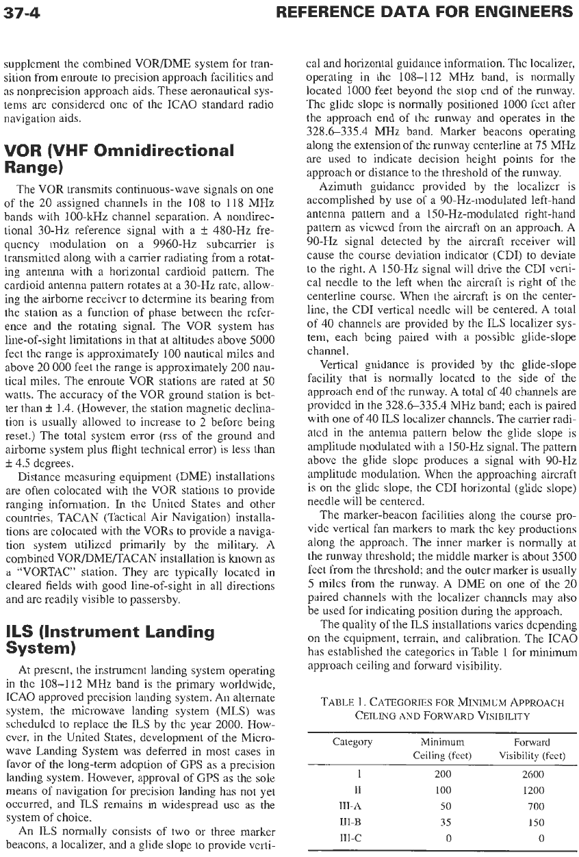
TABLE
1.
CATEGORIES
FOR
MLWUM APPROACH
CEILING
AID
FORWARD VISIBILITY
Category Minimum
Forward
Ceiling (feet) Visibility (feet)
I
200 2600
I1
100 1200
111-A 50 700
111-B 35 150
111-c 0 0
37-5
DME (Distance Measuring
Equipment)
The airborne equipment (interrogator) generates a
pulsed signal that is recognized by the ground equip-
ment (transponder); the transponder then transmits a
reply that is identified by the tracking circuit in the
interrogator. The distance is computed by measuring
the total round-trip time of interrogation, reply, and
fixed delay introduced by the ground transponder. The
airborne interrogator transmits about 30 pulse pairs per
second
on
one of the 126 allocated channels between
1025 and 1150 MHz. The ground transponder replies
on
one of the paired channels in the 962-1024 MHz
band or 1151-1213 MHz band. A DME and a colo-
cated VOR constitute the ICAO standard
p-6
system.
TACAN (Tactical Air
Navigation)
The TACAN system provides both omnibearing and
distance-measuring capability. The rotating directional
horizontal-plane radiation pattern produces the azi-
muth signal, which contains a coarse (15 Hz) and a
fine (135 Hz) azimuth element. The rotation of the pat-
tern at 15
Hz
results in a modulation of the carrier with
a composite 15-Hz sine wave. Reference signals are
transmitted by coded pulse trains to provide the phase
reference. The airborne receiver
obtains
bearing by
comparing the 15-Hz and 135-Hz sine waves with the
reference pulse groups. The TACAN system operates
in the 960-1215 MHz band with 1-MHz channel sepa-
rations.
MLS (Microwave Landing
System)
The microwave landing system is an ICAO-
approved replacement for the current ILS system.
However, the advent of GPS has placed many of the
plans for deployment of MLS
on
hold. In the United
States, there are
no
plans for widespread deployment
of MLS. The MLS system is based
on
time-referenced
scanning beams (TRSB), referenced to the runway,
which enable the airborne unit to determine precise
azimuth angle and elevation angle. The angular posi-
tion of the aircraft is determined by measuring the time
intervals between the TO and FROM azimuth antenna
beam scan and the UP and DOWN scan of the eleva-
tion antenna pattern. The time interval represents a
unique position within the range of the scanning
beams. The azimuth scan is typically 60 degrees either
side of the runway centerline, and the elevation scan is
from
0
to 30 degrees. The signal format provides for
360-degree azimuth coverage for future implementa-
tion. 200 channels in the 5000-5250 MHz band pro-
vide the azimuth and elevation angle functions. Range
information is provided by DMEs operating in the
960-1215 MHz band.
An
option is included in the sig-
nal format to permit a special-purpose system operat-
ing in the 15 400-15
700
MHz band.
ATCRBS (Air Traffic Control
Radar Beacon System)
The ATCRBS ground interrogator transmits at
1030
MHz with a rotating
(5
Hz enroute and 2.5 Hz terminal
areas) directional antenna pattern. The interrogator
transmits approximately
400
pulse pairs per second
and receives replies from aircraft transponders that are
within the beam of the antenna pattern. The airborne
transponder replies at 1090 MHz with one of the 4096
pulse codes available. The decoded replies are dis-
played
on
the surveillance radar ppi along with pri-
mary radar returns. An omnidirectional pulsed pattern
is also radiated from the ground to suppress unwanted
sidelobe replies. This system is often referred
to
as
secondary surveillance radar.
Transit
The Transit satellite navigation system consisted of
a constellation of satellites in approximately 600-
nautical-mile polar orbits. The system, now deacti-
vated, was operated by the
US
Navy. The satellites
broadcast ephemeris information continuously at
150
MHz and 400 MHz. A receiver measures successive
Doppler shifts of the signal as the satellite approaches
or passes the user. The geographic position of the
receiver is then calculated from the satellite position
information (transmitted from the satellite every two
minutes) and the measurement of the Doppler shift.
Normally only one frequency
(400
MHz) is used for
navigation, and the other is used when ionosphere cor-
rection (for improved accuracy) is performed. Cover-
age was worldwide but
not
continuous due to the
relatively low altitude and the low number of satellites.
The update of navigation (time between satellite fixes)
was as short as
1
hour and up to
8
hours, depending
on
latitude. The Transit system has been replaced by the
Global Positioning System (GPS).
TCAS (Traffic Alert and
Co
I
I
is
i
o
n Avoidance Systems)
The TCAS collision avoidance system permits air-
craft
to
interrogate each other’s transponder beacons.
The response
to
an interrogation is processed
to
pro-
vide relative range information. Relative altitude infor-
mation is derived from a comparison of the altimeter
information coded into the transponder’s reply and the
interrogating aircraft’s knowledge of its own altitude.
When automatic computer computations indicate that
a collision is probable, either a traffic advisory (TA) or
a resolution advisory (RA) is provided to the pilot of
the interrogating aircraft. The more sophisticated
RA
37-6
REFERENCE
DATA
FOR ENGINEERS
is available only in the TCAS-I1 implementation. The
RA directs the pilot to perform
a
specific maneuver
to
avoid
a
collision. TCAS-I is installed on small com-
mercial aircraft (10-30 passengers) and TCAS-I1 on
large transport aircraft.
N
AVSTA
R/G
I
o
ba
I
Position
i
n
g
System
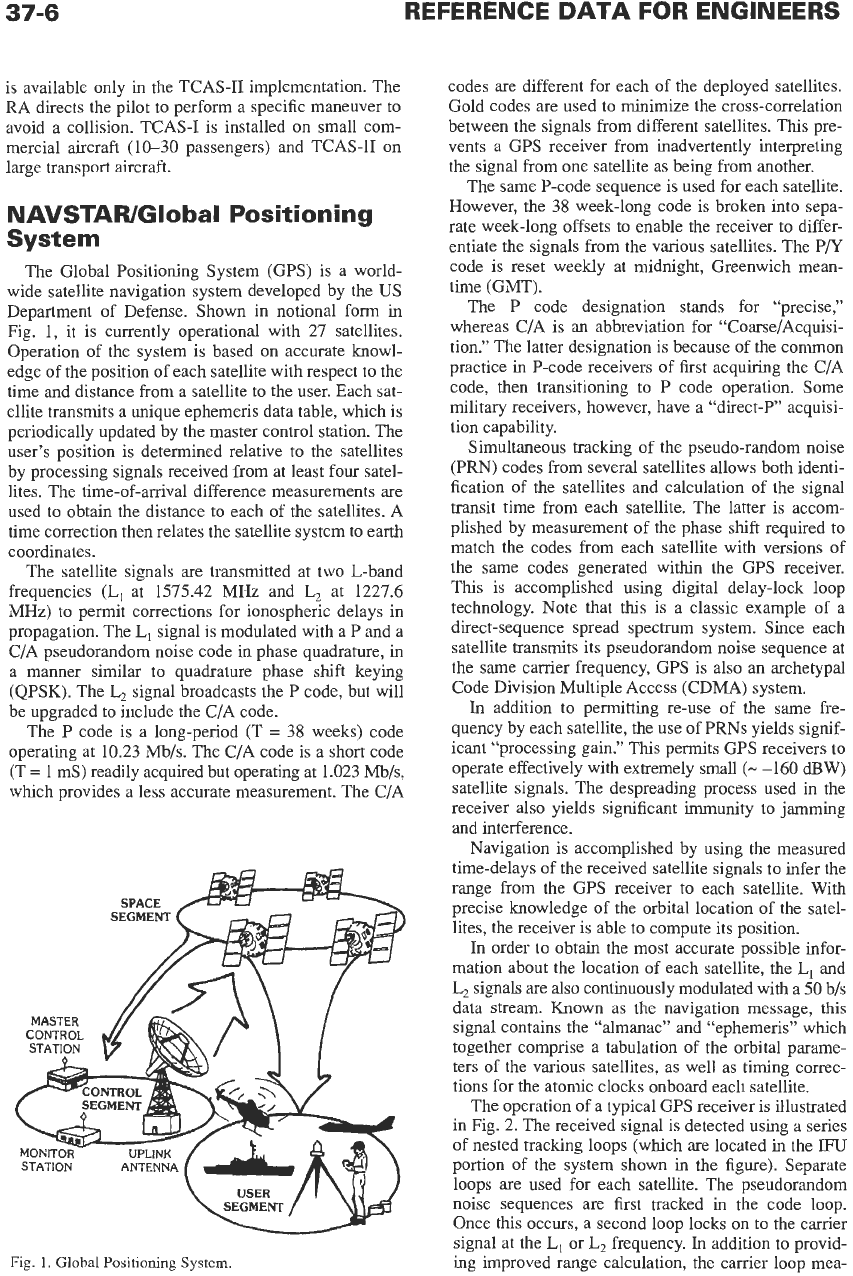
The Global Positioning System (GPS) is
a
world-
wide satellite navigation system developed by the
US
Department of Defense. Shown in notional form in
Fig.
1,
it is currently operational with 27 satellites.
Operation of the system is based on accurate knowl-
edge of the position of each satellite with respect to the
time and distance from
a
satellite to the user. Each sat-
ellite transmits a unique ephemeris data table, which is
periodically updated by the master control station. The
user’s position is determined relative to the satellites
by processing signals received from at least four satel-
lites. The time-of-arrival difference measurements are
used to obtain the distance to each of the satellites. A
time correction then relates the satellite system to earth
coordinates.
The satellite signals
are
transmitted at two L-band
frequencies
(L,
at 1575.42 MHz and
L,
at 1227.6
MHz) to permit corrections for ionospheric delays in
propagation. The
L,
signal is modulated with
a
P and a
CIA pseudorandom noise code in phase quadrature, in
a
manner similar to quadrature phase shift keying
(QPSK). The
L,
signal broadcasts the
P
code, but will
be upgraded to include the C/A code.
The
P
code is
a
long-period (T
=
38 weeks) code
operating at 10.23
Mb/s.
The CIA code is a short code
(T
=
1
mS) readily acquired but operating at 1.023
Mb/s,
which provides a less accurate measurement. The C/A
MONITOR-
STATION
Fig.
1.
Global
Positioning
System.
codes
are
different for each of the deployed satellites.
Gold codes are used to minimize the cross-correlation
between the signals from different satellites. This pre-
vents
a
GPS receiver from inadvertently interpreting
the signal from one satellite as being from another.
The same P-code sequence is used for each satellite.
However, the
38
week-long code is broken into sepa-
rate week-long offsets
to
enable the receiver to differ-
entiate the signals from the various satellites. The P/Y
code
is
reset weekly
at
midnight, Greenwich mean-
time (GMT).
The P code designation stands for “precise,”
whereas CIA is an abbreviation for “Coarse/Acquisi-
tion.” The latter designation is because of the common
practice in P-code receivers of first acquiring the CIA
code, then transitioning to
P
code operation. Some
military receivers, however, have
a
“direct-P” acquisi-
tion capability.
Simultaneous tracking of the pseudo-random noise
(PRN) codes from several satellites allows both identi-
fication of the satellites and calculation of the signal
transit time from each satellite. The latter is accom-
plished by measurement of the phase shift required
to
match the codes from each satellite with versions of
the same codes generated within the GPS receiver.
This
is
accomplished using digital delay-lock loop
technology. Note that
this
is
a
classic example of
a
direct-sequence spread spectrum system. Since each
satellite transmits its pseudorandom noise sequence at
the same carrier frequency, GPS is
also
an
archetypal
Code Division Multiple Access (CDMA) system.
In
addition to permitting re-use
of
the same fre-
quency by each satellite, the use of PRNs yields signif-
icant “processing gain.” This permits GPS receivers to
operate effectively with extremely small
(-
-160
dBW)
satellite signals. The despreading process used in the
receiver also yields significant immunity
to
jamming
and interference.
Navigation is accomplished by using the measured
time-delays of the received satellite signals to infer the
range from the GPS receiver to each satellite. With
precise knowledge of the orbital location of the satel-
lites, the receiver is able to compute its position.
In
order to obtain the most accurate possible infor-
mation about the location of each satellite, the
L,
and
L2
signals are also continuously modulated with
a
50
b/s
data stream.
Known
as
the
navigation message,
this
signal contains the “almanac” and “ephemeris” which
together comprise
a
tabulation of the orbital parame-
ters of the various satellites. as well
as
timing correc-
tions for the atomic clocks onboard each satellite.
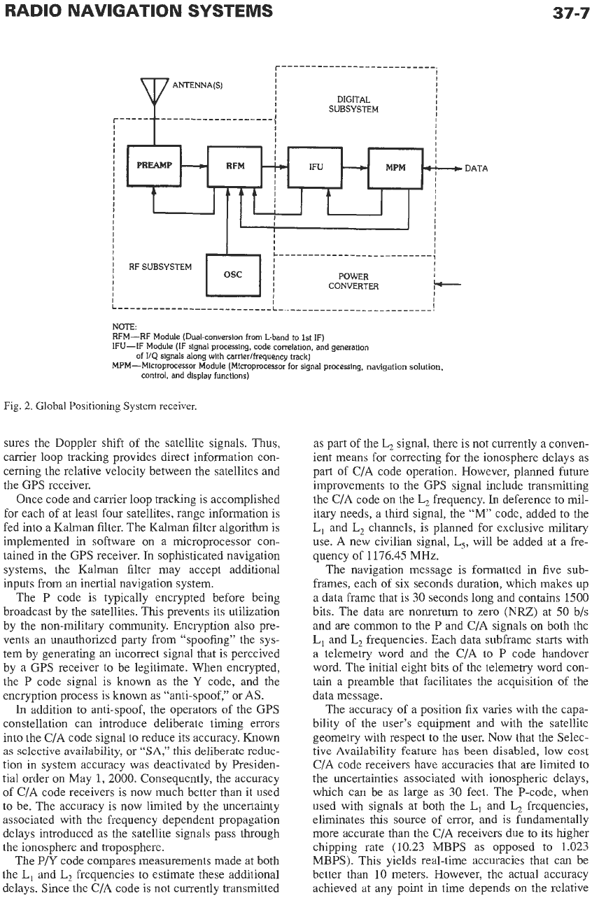
The operation of a typical GPS receiver is illustrated
in Fig. 2. The received signal is detected using
a
series
of nested tracking loops (which are located
in
the
IFU
portion of the system shown in the figure). Separate
loops are used for each satellite. The pseudorandom
noise sequences are first tracked in the code loop.
Once this occurs,
a
second loop locks on to the carrier
signal
at
the
L,
or
L,
frequency.
In
addition
to
provid-
ing improved range calculation, the carrier loop mea-
RADIO NAVIGATION
SYSTEMS
37-7
I
I
I
I
ANTENNA(S1
I
I
I
I
I
DIGITAL
I
I
SUBSYSTEM
!
I
I
I
I
DATA
I
-;
I
I
:--------------------------~--------------------------!
NOTE:
RFM-RF Module (Dual-conversion from L-band
to
1st
IF)
IFU-IF Module (IF signal processing, code correlation, and generation
MPM-Microprocessor Module (Microprocessor
for
signal processing,
navigation
solution,
of
114
signals along with carrierlfrequency track)
control, and display functions)
Fig.
2.
Global Positioning
System
receiver.
sures the Doppler shift of the satellite signals.
Thus,
carrier loop tracking provides direct information con-
cerning
the
relative velocity between the satellites and
the GPS receiver.
Once code and carrier loop tracking is accomplished
for each of at least four satellites, range information is
fed into a Kalman filter. The Kalman filter algorithm is
implemented in software
on
a microprocessor con-
tained
in
the
GPS receiver.
In
sophisticated navigation
systems, the Kalman filter may accept additional
inputs from an inertial navigation system.
The
P
code is typically encrypted before being
broadcast by the satellites. This prevents its utilization
by the non-military community. Encryption also pre-
vents
an
unauthorized party from “spoofing” the sys-
tem by generating
an
incorrect signal that is perceived
by a GPS receiver to be legitimate. When encrypted,
the
P
code signal
is
known as the
Y
code, and the
encryption process is known as “anti-spoof,’’ or
AS.
In
addition to anti-spoof, the operators of the GPS
constellation can introduce deliberate timing errors
into the CIA code signal to reduce its accuracy. Known
as selective availability, or
“SA,”
this deliberate reduc-
tion in system accuracy was deactivated by Presiden-
tial order on May 1,2000. Consequently, the accuracy
of CIA code receivers is now much better than it used
to be. The accuracy is now limited by the uncertainty
associated with the frequency dependent propagation
delays introduced as the satellite signals pass through
the ionosphere and troposphere.
The
P/Y
code compares measurements made at both
the
L,
and
L,
frequencies to estimate these additional
delays. Since the CIA code is not currently transmitted
as part of the
L,
signal, there is not currently a conven-
ient means for correcting for the ionosphere delays as
part of C/A code operation. However, planned future
improvements to the GPS signal include transmitting
the CIA code
on
the
L,
frequency.
In
deference to mil-
itary needs, a third signal, the
“M’
code, added to the
L,
and
L,
channels, is planned for exclusive military
use.
A
new civilian signal,
L,,
will be added at a fre-
quency of
1176.45
MHz.
The navigation message is formatted in five sub-
frames, each of six seconds duration, which makes up
a data frame that is 30 seconds long and contains 1500
bits. The data are nonretum to zero
(NU)
at 50 b/s
and are common to the
P
and CIA signals on both the
L,
and
L,
frequencies. Each data subframe starts with
a telemetry word and the CIA to P code handover
word. The initial eight bits of the telemetry word con-
tain a preamble that facilitates the acquisition of the
data message.
The accuracy of a position fix varies with the capa-
bility
of
the user’s equipment and with the satellite
geometry with respect to the user. Now that the Selec-
tive Availability feature has been disabled,
low
cost
C/A code receivers have accuracies that are limited to
the uncertainties associated with ionospheric delays,
which can be as large as 30 feet. The P-code, when
used with signals at both the
L,
and
L,
frequencies,
eliminates this source
of
error, and is fundamentally
more accurate than the CIA receivers due to its higher
chipping rate (10.23 MBPS as opposed
to
1.023
MBPS). This yields real-time accuracies that can be
better than
10
meters. However, the actual accuracy
achieved at any point in time depends
on
the relative
37-8
geometry between the user and the observed satellites.
For example, an ideal situation would be
to
have one
or more satellites be directly overhead, and for
a
mini-
mum of three additional satellites
to
be slightly above
the horizon at 120-degree intervals.
Accuracy can be further improved by utilizing addi-
tional satellites. Many GPS receivers now have the
capability to track up to 12 satellites simultaneously.
Because the GPS constellation, as currently deployed,
has 27 satellites, it is conceivable that more than 12
might be visible simultaneously. However, the accu-
racy improvement due to tracking more than 12 satel-
lites is likely negligible.
Differential
GPS
Another approach
to
improving accuracy is to use
differential GPS, in which one measures the difference
in position between two receivers. It is quite common
for benchmark locations to be surveyed with consider-
able accuracy. A GPS receiver located at the bench-
mark then provides real-time calibration of the GPS-
derived position versus its “ground-truth” fix. Correc-
tion signals, which are useful for receivers
as
far
as
a
few hundred miles away, are then broadcast using
a
variety of beacon systems. For example, the Coast
Guard operates
a
beacon system
at
frequencies of
approximately 300
kHz
in the coastal areas of the
United States and along the Mississippi River. Many
low-cost receivers are already pre-equipped to process
this differential correction signal. Accuracies
to
better
than 6 feet are routine with differential GPS. With
additional time-integration and/or post-processing,
accuracies to the sub-centimeter level have been
achieved.
Future Trends
In
order for GPS to serve
as
the single-navigation
source for commercial air transportation, its accuracy,
availability, and reliability must be improved. The plan
for accomplishing this is known
as
the Wide Area Aug-
mentation Service, or WAAS. This will be
a
network of
ground-based reference systems whose correction sig-
nals are broadcast via
a
network of geostationary satel-
lites. WAAS-capable receivers will also utilize integrity
checking algorithms to verify that the instantaneous
operation of the system meets the strict requirements of
a
safety-of-life navigation system.
To
further improve the accuracy of CIA code receiv-
ers, it is planned to include the CIA signal
on
the
L,
broadcast, thus allowing for elimination of ionospheric
delays.
To
further separate the needs of military users
from those of civil users,
a
third signal, the M-code, is
planned for inclusion at the
L,
and L, frequencies. A
new signal, L,, will be broadcast for civilian use at
1176.45 MHz.
In
a
similar fashion,
a
Local Area Augmentation Ser-
vice (LAAS) will enable GPS to be used for Category-I
and higher instrument landings without the need for
conventional
ILS
equipment.
An additional alternative
to
the
ILS,
for the military,
is the Joint Precision Approach and Landing System
(JPALS). Communication networks, such
as
the Joint
Tactical Information Distribution System (JTIDS) will
also provide an incipient radio navigation capability to
its users.
A
system known
as
automatic dependent surveil-
lance (ADS) is being developed in which aircraft
broadcast their own navigation data
to
other, nearby
aircraft.
Finally, the existing Russian GLONASS System
and the Proposed European Gallileo System provide
similar capabilities to GPS. The GLONASS system,
which is
a
frequency division multiple access (FDMA)
system,
as
opposed to
a
CDMA system like GPS, has
a
questionable long-term future for economic reasons.
Likewise, development and deployment
of
Gallileo is
likely to be affected by economic considerations.
REFERENCES
1.
Beser, J., and Parkinson, B.
W.
“The Application of
NAVSTAR Differential GPS in the Civilian Com-
munity.”Navigation,
Vol. 29, No.
2,
Summer 1982.
2. Borty,
J.
E.,
Gupta,
R.
R., Scull,
D.
C., and
Moms,
P.
B.
“OMEGA Signal Coverage Prediction.”
Nav-
igation,
Vol. 23, No. 1, Spring 1976.
3. Bowditch,
N.
American Practical Navigator.
US
Navy Hydrographic Office, Publ. 9, 1958.
4. Copps, E. M., Geier, G. J., Fidler,
W.
C., and
Grundy,
P.
A., “Optimal Processing of GPS Sig-
nals.”
Navigation,
Vol. 27, No. 3, Fall 1980.
5. Frank, Robert L. “History
of
Loran C.”
Naviga-
tion,
Vol. 29, No. 1, Spring 1982.
6.
Fritch, V.
J.,
and Sanders, L. J. “Instrument Land-
ing Systems.”
IEEE Communications,
May 1973,
7. Garrett,
P.
H. “Advances in Low-Frequency Radio
Navigation Methods.”
IEEE Transactions on Aero-
space and Electronic Systems,
July 1975, pp. 562-
574.
8.
Handbook: VORA/’ORTAC Siting Criteria. FAA,
Department
of
Transportation,
1968.
9.
IEEE Transactions
on
Aerospace Navigation Elec-
tronics.
Special issue on the VOR/DME naviga-
tion system-Its present capabilities and future
potential, Vol. Am-12, March 1964.
10. Johnson, C., and Ward,
P.
“GPS Applications to
the Seismic Oil Exploration.”
Navigation,
Vol. 26,
No.
2, Summer 1979.
11.
Kayton, M., and Fried, W. R.
Avionics Navigation
Systems, 2nd ed.
New York: John Wiley
&
Sons,
Inc., 1997.
pp. 435-454.
12. Kelly, R. J. “Time Reference Microwave Landing
System Multipath Control Techniques.”
Naviga-
tion,
Vol. 23, No. 1, Spring 1976.
13. Logsdon, Tom.
Understanding the Navstar; GPS,
GIs,
and
WHS,
2nd ed.
New York: Chapman and
Hall, 1995.
14.
Loran C User Handbook COMDTINST
M16562.3,
US
Coast Guard (G-NRN-3), Washington, DC.
15. Microwave Landing System Signal Format and
System Level Functional Requirements, FAA-ER-
70008C. April 1979.
16.
Navigation: Journal
of
the Institute
of
Navigation.
Vol. 25, No. 2, Summer 1978; Special issue with
coverage
of
NAVSTAR Global Position System.
17. Pierce,
J.
A. “OMEGA.”
IEEE Transactions on
Aerospace and Electronic Systems,
Vol.
AES-1,
December 1965, pp. 206-215.
18. Pierce, J. A., and Woodward, R.
H.
“The Develop-
ment of Long Range Hyperbolic Navigation in the
United States.”
Navigation,
Vol. 18, No. 1, Spring
1971.
19. Pisacane, V.
L., Holland,
B. B.
and Black,
H.
D.
“Recent Improvements in the Navy Navigational
Satellite System.”
Navigation,
Vol. 20, 1973.
20. Poppe, Martin. “The Loran-C Receiver, A Func-
tional Description.”
Navigation,
Vol. 29, No. 1,
Spring 1982.
21. Stansell, T. A., Jr. “The Navy Navigation Satellite
System; Description and Status.”
Navigation,
Vol.
15, No. 3, Fall 1968.
22. Swanson, E. R. “OMEGA Possibilities: Limita-
tions, Options, and Opportunities.”
Navigation,
Vol. 26, No. 3, Fall 1979.
23. Vass,
E.
R. “OMEGA Navigation System: Present
Status and Plans 1977-1980.”
Navigation,
Vol. 25,
No.
1, Spring 1978.
24. Watt, A.
D.
VLF
Radio Engineering.
Elmsford,
N.Y.: Pergamon Press, Inc., 1967.
25. Winnick, A.
B., and Brandewie, D. M. “Recent
VORDME System Improvements.”
Proceedings
of
the IEEE,
Vol.
58,
March 1970.
26. Zimmerman, W. “Optimum Integration of Aircraft
Navigation Systems.”
IEEE Transactions
on
Aero-
space and Electronic Systems,
Vol. AES-5, Sep-
tember 1969.