Novak P. Developments in hydraulic engineering - Vol. 5
Подождите немного. Документ загружается.

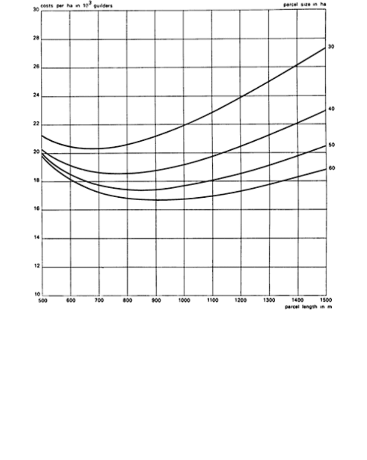
FIG. 7. Calculation of optimal plot
sizes.
— yield depression on levelled spoil banks of ditches and main ditches;
— maintenance costs of slopes of main ditches;
— road ditches and parcel ditches;
— costs for installation and maintenance of subsurface drains;
— costs for the idle hours of tractors and machinery and commuting of workers;
— costs for transport of fertilizers, sowing seeds and harvest;
— yield depression on headlands and along parcel boundaries;
— turning costs of machinery.
The best lot length and lot width is a function of the lot size (see Fig. 7). For lots of 30 ha
in this example the best dimensions are 450×700 m; for 60 ha, 600×1000 m. With still
greater length the costs increase only slightly. For different types of farming the
principles are the same.
Farmers usually live in villages, probably for safety reasons, and although this has
advantages for social life it is disadvantageous for transport. In the IJsselmeerpolders in
Polders 189

the Netherlands a farm usually consists of 1.5 or 2 lots, so that the size of the standard lot
has a considerable influence on farm sizes. The farm buildings are usually positioned
along the road in a corner of the lot.
Regarding the infrastructure, a choice should be made between a road system and/or
navigation canals. If navigation canals are chosen, either the drainage or irrigation canals
should be made suitable for this purpose. In considering the alternatives, their costs and
the purpose of the polder (small-holdings polder or estate polder) have to be taken into
account.
4.2.4 Soil
Special attention should also be paid to water management, in the polder areas where the
soil consists of acid sulphate clay, which can reduce the harmful effects of acidity. In the
beginning of reclamation a high ground water table should be maintained to be lowered
only slowly during subsequent years. Flushing of the soil, even with salt water, after a dry
period also has a very favourable effect on the quality of the ground water.
7
4.2.5 Reclamation
During reclamation several steps may be required to convert swampy lands into fertile
soils which from the point of view of economy may influence the final layout of the
polder.
Reclamation may be carried out in a relatively short period, over some years, or
gradually as a long-term process, such as in the lowland development strategy in
Indonesia. This strategy is based on several national development objectives, such as
resettlement of people from the densely populated islands to unoccupied areas and
increase of food production with emphasis on rice growing. The reclamation of tidal
coastal lowlands is here characterized by a step-by-step development initiated by quick-
yielding drainage projects based on low input and simple technology, to be followed by
higher input and more sophisticated technology after the former stage has reached its
optimal economic development, until the most modern and highest input technologies
have been applied to achieve the maximum natural and socio-economic resource
utilization. At this stage the level of advanced polders has been reached. The reasons for
the step-by-step development are the lower initial costs needed to reclaim the large areas,
and the time allowed. Another reason is that all the people concerned become familiar
with the reclamation of swampy lowland. Features of the various stages with regard to
water management infrastructure and kind of land use are as follows:
(1) First stage: open uncontrolled drainage system; rain-fed agriculture; one food crop
annually; subsistence farming; main transportation by boats;
(2) Intermediate stages: semi-closed drainage system; semicontrolled water management
based on flood and saline water protection; flushing in the case of acid sulphate soils
and water conservation by surface and subsurface water control; mainly rain-fed
agriculture; more than one crop annually; intermediate economic land farming; agro-
processing industry and internal road system; trans-area transport;
Developments in hydraulic engineering–5 190

(3) Final stage: closed system/fully controlled water management/ pumping; irrigation
system; multiple cropping and integrated farming; commercial farming; sustained
economic growth; industries and complete road-infrastructure system.
In this type of lowland development the water management system is based in the first
place on drainage of tidal lowlands by gravity, making use of the tidal movement. Since,
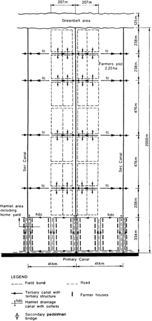
in the initial stage, only one rain-fed crop can be grown, farm sizes of 1·75–2·25 ha
enable farmers to reach subsistence level (see Fig. 8). When the areas are developed
further, the initial system will always be the starting point for further adaptations.
Irrigation potential in particular can be reduced when too much attention is paid in the
beginning to drainage only.
4.2.6 Geohydrology
The level of the surface water in a polder is generally low compared with the water table
in adjacent areas, often resulting in seepage and damage to the crops when the seepage
water is saline. Lowering of the ground water table in adjacent lands may also cause
damage there (drying out of the land, subsidence, etc.).
4.2.7 Water Quality
Water quality plays a role both inside and outside the polder. Inside, salinity or alkalinity
in particular can cause damage to the crops in the root zone. Outside, the required water
quality in the receiving water body may put constraints on the discharge possibilities. If,
for example, the
Polders 191
Developments in hydraulic engineering–5 192
FIG. 8. Basic farm size, tidal lowlands,
Indonesia.
water in the polder has a high salinity content due to saline seepage and the receiving
water body has to be kept fresh, special measures have to be taken to prevent ‘pollution
of the receiving water body’.
4.3 Design of the Drainage System
When designing the water management system of the polder, two design approaches may
be followed: empirical design and optimization. Empirical design is normally based on
the conditions that have occurred in the past from which general data have been deduced.
In the optimization approach the investments and maintenance costs of the water
management system are compared with the yields and damage that can be expected in
relation to the functioning of the system.
12
The requirements of the land drainage system form the starting point in the design. For
rice, the normal depth of flooding should not be exceeded too many times by a certain
depth. For dry food crops the depth of the ground water table below the surface has to be
controlled.
From the hydraulic characteristics of the land drainage system the amount of water to
be evacuated can be derived to obtain the required degree of water control. Outlet
capacity depends very much on the admissible storage in the polder.
Storage may be on the field, in the soil and in the open water system. Criteria for
storage on the field, e.g. for rice crops, will largely depend on the type of crop and the
stage of crop development. For old rice varieties a regular variation of the water layer on
the field of 0·05–0·10 m is allowed. In the case of high-yielding varieties of rice the
admissible surface storage on the fields is about 0·10 m with a return period of 5–20
years. Storage in the soil is important for dry food crops in temperate climates and may
amount from 50 to 200 mm after a dry period, without raising the ground water level
above a required depth. Especially significant is surface storage in the open canals, pools
and lakes of the polder area. In areas under cultivation a permissible rise of the polder
water level may vary from 0·10 to 0·40 m.
The design of drainage systems requires geological, topographic and soil maps, and
climatic and agricultural data. Generally the investigations require a sequence of studies
with increasing intensity. Therefore two or three phases in the investigations can be
considered: (a) reconnaissance level (pre-feasibility study)—the main objective is to
identify the feasibility of the proposed project, first of all on technical, but also on
economic grounds; studies at this level are mainly based on existing information but may
also include some field work; (b) semi-detailed level (feasibility study) —alternative
plans obtained from the reconnaissance study are worked out to a preliminary plan so that
the competent authorities can make a decision; the data are the same as for the
reconnaissance level, but are needed in more detail; (c) detailed level (project designs)—
design of the selected project, including a list of quantities and preparation of tender
documents.
Polders 193

Regarding the different data to be used in the studies, three types of variability have to
be taken into account:
13
variability caused by inaccuracies of the method applied,
variability in space, and variability in time.
4.3.1 Design of the Land Drainage System
Land drainage in polders is to prevent the occurrence of excessive moist conditions in the
root zone. In arid areas, a further objective is to prevent the accumulation of salt in the
root zone, or to leach accumulated salts out of the soil profile.
For the design of the land drainage system the reconnaissance level is used to
investigate the need for drainage, as well as the type of drainage system. At the semi-
detailed level an estimate is made of the costs, thus also the necessary drain spacings
have to be estimated. In general the following information is used to make a land
drainage plan:
— elevation, preferably contour intervals of 0·25 m or less;
— topography and infrastructure on maps 1:2500 or 1:10000 to indicate land use,
obstructions like open drains, canals and roads, outlet possibilities;
— soil texture to decide on drain depth and to estimate hydraulic conductivity;
— depth of impervious or impeding layers;
— hydraulic conductivity especially of soil layers between 1·0 and 2·5 m depth;
— ground water tables and fluctuations;
— ground water potentials at different depths;
— salinity of irrigation water and ground water;
— soil salinity and alkalinity;
— infiltration rate.
The ground water table is usually curved, its elevation being the highest midway between
the drains. The factors influencing the height of the water table are:
— precipitation, irrigation and other sources of recharge;
— evapotranspiration and other sources of discharge;
— soil properties;
— depth, spacing and diameter of the drains;
— water level in the drains.
These factors are interrelated by drainage equations based on the assumptions of two-
dimensional flow and of a uniform distribution of the recharge, steady or non-steady,
over the area between the drains.
For the design of open field drains or subsurface drains, different steady state or non-
steady state formulae are available such as those of Hooghoudt, Ernst, Glover-Dumm
etc.
14
The steady state formulae are derived under the assumption that the recharge
intensity equals the drain discharge and that the water table consequently remains in
position. The non-steady state approach considers the fluctuations of the water table in
time under the influence of a non-steady recharge. For steady state ground water
conditions the drainage criterion has two parameters: height of the ground water table
Developments in hydraulic engineering–5 194

midway between the drains and the discharge. The other parameters in the formulae
represent the soil characteristics and the spacing and diameter of the drains. For non-
steady state ground water conditions the criteria are formulated in terms of a required rate
of lowering of the ground water table. The appropriate choice of drainage criteria will
depend on the following set of conditions:
— hydrological conditions determining the quantity of excess water to be drained within
a specified time;
— agronomic conditions determining the permissible upper limit of the water table and
its duration;
— soil conditions determining the relations between aeration and moisture content,
ground water level and soil moisture content, ground water level and capillary rise;
— economic conditions determining the cost/benefit ratio between installation costs and
benefits of better drainage conditions.
Since these conditions are complex and interrelated, the drainage criterion should be
regarded as a simple approach to express the aims of a land drainage system in one or
two simple parameters.
4.3.2 Layout of the System
Open field drains are normally installed parallel to each other perpendicular to the
ditches. In subsurface drains three types of systems can be distinguished: random or
irregular systems used to drain depressions or for interception of seepage in dikes; single
parallel pipe drain systems, where each subsurface drain has its own outlet to a ditch;
composite pipe drain systems with subsurface drains and collector drains.
In homogeneous soils the greater the depth of the subsurface drains the wider their
spacing. In practice the installation depth is limited by: installation costs, presence of low
permeable layers, and the water level in the open drainage system. In humid areas the
depth is usually between 0·90 and 1·20 m below the surface. In irrigated areas greater
depths are chosen between 1·50 and 2·00 m below surface, especially for ‘salt drainage’.
The slope of the drains in flat areas is generally 0·10 m per 100 m, and the maximum
length of subsurface drains between 250 and 300 m (because of maintenance). For
collectors slopes vary from 0·03 to 0–06 m per 100 m with lengths of up to 500 m.
The layout of the system is mainly dictated by the infrastructure and the position of the
outlet facilities.
4.3.3 Discharge Capacity of Subsurface Drains
The diameters of subsurface drains and collectors must be such that their capacity is
sufficient without considerable surcharge. For design, the most convenient way of
computing the head-loss in drainage pipes is to use expressions relating the maximum
drainable area A (ha), the drainage duty q (m/day), the average hydraulic gradient i, and
pipe diameter d (m). For corrugated PVC pipes, Ven and Dekker
15
arrived at:
Polders 195
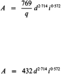
For smooth pipes, Wesseling
14
found:
The equations are derived for full flowing clean pipes and linear increase in discharge
from 0 at the upstream end to maximum at the outlet. The available hydraulic gradient is
usually taken as equal to the drain slope (although in reality the hydraulic head-loss line
is curved).
For pipes with a constant flow throughout, the hydraulic gradient is a straight line. For
a smooth transport collector the following applies:
The maximum drainable area in this case is smaller because the full flow has to be
transported over the entire length. In order to compensate for sedimentation inside the
drainage pipe it is common practice to reduce the maximum drainable area to 75% of the
calculated area. A similar safety factor should be obtained when the available hydraulic
head is lowered by 40% allowing pipes to be silted up to 25% of their diameter without
consequences for the discharge capacity. For collectors it is common practice to increase
the pipe diameter in the direction to the outlet, again reducing the maximum drainable
area to 75% in practice.
4.3.4 Design of the Hydraulic Transport System
In truly level areas without any general slope, the design of drainage canals poses a real
problem. The hydraulic gradient required for the flow can only be generated by a gradient
in the water level artificially created by a drawdown at the outlet (sluice or pumping
station) and by allowing the water level in the canal at its upper end to rise. The total of
both heads is limited to about 0·3–0·6 m. This means that, if the length over which the
water has to be transported through the canal is around 10 km, the available hydraulic
gradient is only 0·03–0·06 m/km. Therefore the design velocities of drainage canals in
level areas are necessarily small, of the order of 0·3–0·4 m/s. For the design of the
hydraulic transport system the reconnaissance level is used to investigate the required
principal layout. The information required for design of the hydraulic transport system is
more or less the same as that for the land drainage system, with the addition of data on
soil mechanical aspects and geohydrology of the area under study.
During the reconnaissance level and the semi-detailed level, calculations are normally
based on hydrological routing models, such as the rational formula, the Muskingum
method, reservoir models or steady state hydraulic formulae.
11
At the detailed level,
hydraulic non-steady flow models are nowadays increasingly applied, especially when
urban and industrial areas are involved.
4.3.5 Layout and Discharge Capacity of the Hydraulic Transport System
A complete hydraulic transport system consists of ditches, main ditches and canals. If a
composite subsurface drainage system is installed, the collector drains replace the
Developments in hydraulic engineering–5 196

ditches. Normally the distances between ditches and main ditches are based on
agricultural economy, resulting in optimal plot sizes. The canals are located so that a
minimum of earth movement is required. The possible locations for sluices or pumping
stations also determine the principal location of the canals.
The discharge capacity of the hydraulic transport system is normally such that a
prescribed water level in the polder is not exceeded during a certain time at a certain
return period. This, together with the accepted velocity in the different parts of the
system, determines the cross-sections.
4.3.6 Design of Sluices and Pumping Stations
Drainage by gravity rather than by pump lift is the most attractive solution for tidal parts
of rivers, or tidal estuaries with a sufficient tidal range, or alongside rivers. A difficulty
when applying this principle to polders along rivers lies in the fact that, in general,
periods with heavy local rainfall coincide with periods with flood stages of the river,
making gravity discharge temporarily impossible. The solution is to design a drainage
canal parallel to the river with a gradient smaller than the slope of the river.
The discharge capacity of the sluices or pumping stations has to be calculated in
combination with the discharge capacity of the canals, the available storage, and the
accepted level fluctuations (see Table 2 for illustration).
TABLE 2
INDICATION OF THE REQUIRED DRAINAGE
PUMPING CAPACITY FOR AGRICULTURAL
AND URBAN AREAS IN RELATION TO THE
OPEN WATER STORAGE IN THE REPUBLIC
OF KOREA
Water level rise (m) at: Percentage of open water Pumping capacity (mm/day)
T=10 years T=100 years
a
Field storage is 100mm (rice)
12 22 1·04 2·03
16 12 1·03 1·82
20 10 0·88 1·54
Runoff coefficient of 0·8 (urban area)
12 34 1·00 1·76
16 22 1·00 1·64
20 12 1·00 1·53
a
These are theoretical values; inundation will occur in practice.
Polders 197
4.3.7 Main Drainage System Markerwaard Polder
An illustration of the determination of layout and discharge capacity of the hydraulic
transport system may be found in recent studies for the system of the Markerwaard
polder, the fifth polder of the Zuiderzee project in the Netherlands.
16
The following
relevant information was available:
(1) The main type of land use will be agriculture (>50% of the total area). Depending
on the soil suitability, arable farming, dairy farming, horticulture and fruit growing are
planned, and considerable parts to be used for afforestation and the creation of nature
reserves.
(2) There is a large variation in the texture of the top soil, with medium fine to locally
coarse sand in the north-eastern part gradually changing into loam and clay in the south-
western direction. Locally old marine clay and peat are present.
(2) Based on calculations with computer models for ground water flow (finite
elements method), average seepage after reclamation is estimated at 0·7 mm/day.
(4) In the northern part, the deeper ground water has a chloride content ranging from
1000 to 3000 mg Cl/litre; on the south-western part it is 100–1000 mg Cl/litre.
(5) The elevation of the lake bottom at emergence ranges from about 2·0 to 4·8 m
below mean sea level. Because of ripening and dewatering of the loosely packed marine
sediments, considerable subsidence will occur after emergence, accurate prognosis being
possible on the basis of the available data. For the design of the drainage system, surface
levels 80–100 years after emergence are taken as decisive.
Boundary conditions for the design. Based on information and practice in the existing
IJsselmeerpolders, the following items were taken into consideration:
(a) For agriculture the minimum required depth of the subsurface pipe drains at the
outlet is 1·10 m below the soil surface, and for fruit orchards 1·30 m. To avoid frequent
submerging of the subsurface drain outlets, the polder water level should be at least 1·40
m below the soil surface. A freeboard of 0·30 m is sufficient to account for flow
resistance and temporarily higher water levels due to wind effects and rainy periods.
(b) The acceptable exceedance frequency for the polder water level in the main
drainage system is: 0·40 m once in 2 years; 0·65 m once in 10 years.
(c) The pumping station(s) should be located at the south-eastern dike of the polder
because of the salt load. From here the water pumped out can be discharged via
Amsterdam to the North Sea, thus minimizing negative effects on the quality of the fresh
water in the surrounding lakes.
(d) The drainage system may be designed for agriculture, with respect to the polder
water level and pumping capacity, thus giving enough flexibility for final land use
planning.
Developments in hydraulic engineering–5 198