Pavlinov I.Ya. (ed.) Research in Biodiversity - Models and Applications
Подождите немного. Документ загружается.

Evaluating Biodiversity and Spatial Simulation
of Land-Cover Change in the Tropical Region of Western Ghats, India
119
Supervised classification technique was used to classify satellite image of 2004 (LISS-III)
based on the information of terrain, topography and species database collected during the
landscape-biodiversity characterization program for the Western Ghats region (Anonymous,
2002). Using the 2004 vegetation and land cover map, an area of interest (AOI) was selected
for the evergreen patches of 1973 using MSS data assuming that these patches of 2004 had
remained unchanged from 1973. The reflectance properties of the evergreen and semi-
evergreen patches for the both the satellite images showed similar trends (Fig. 3). Taking
into consideration of the above criteria, the 1973 MSS image and LISS-III 2004 image were
used to generate the LULC maps of 1973 and 2004. Likewise, all the spectral classes were
assigned training sets from the geometrically corrected images and were then classified. The
maximum likelihood algorithm was used to classify these scenes (Lillesand & Kiefer, 2000).
Major forest types delineated were tropical evergreen, semi-evergreen, moist deciduous, dry
deciduous, dry evergreen, grasslands, scrubs, reeds (Ochlandra sp.), and orchards. The tone
and textural differences in these forest types can be clearly seen in the satellite imagery (Fig.
2). The classified vegetation map was validated by verification on ground and found to be
85% accurate. Finally, IRS LISS-III dataset were resampled to 80m (equivalent to MSS) to
facilitate comparison.
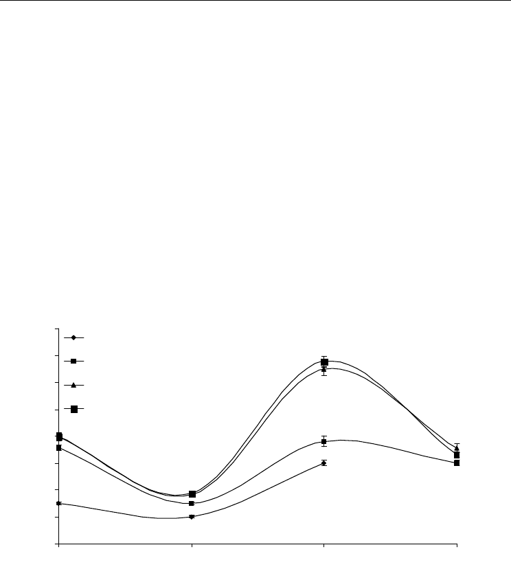
Reflectance Value
* Short wave infra red (SWIR) of IRS P6 LISS III (March 2004) was used to analyse the pixel differentiation
0
20
40
60
80
100
120
140
160
1234
Evergreen Pixels of 1973
Evergreen Pixels of 2004 (No-change)
Change areas (SEG) with respect to EG 1973
Semievergreen of 2004
Green
Red
NIR SWIR
Fig. 3. Spectral reflectance value (X-axis has spectral bands and Y-axis has reflectance value)
differentiating evergreen and semi-evergreen forest types of KMTR, Southern Western
Ghats of Tamil Nadu, India.
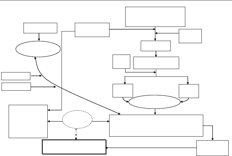
A brief methodology describing land-cover change analysis carried out for the present study
is given in Fig 4. It combines information on phytosociology (no-change and change- areas
plots) and land-cover information, modelling evergreen change using spatial drivers to
identify areas for biodiversity monitoring and prioritization.
Research in Biodiversity – Models and Applications
120
Rectified
LANDSAT-MSS March 1973
IRS LISS-III March 2004
Temporal patterns
of spectral analysis
Supervised
Classification
Training set
allocation
Classified
forest types / land cover
Ground
truth
Final map
1973
Final map
2004
Land cover
Change detection
Phytosociological
analysis
Changes in
Species composition
Species richness
Species diversity
Endemism
Edge category
Major Land cover changes
Evergreen to Disturbed evergreen / Semi-evergreen
Semi-evergreen to Reed brakes
Patch characterization / Fragmentation
No-Change areas
Change areas
Land cover change
Modeling using
GEOMOD
Conservation Planning /
Identification of monitoring sites
Species composition
Change detection
Integrated
analysis
Fig. 4. Methodology used for the study region combining satellite based land-cover and
phytosociological information to characterize areas for conservation planning
2.4 Landscape analysis
Landscape is defined as “an aggregation of heterogeneous elements, which interact with
each other”. Landscape has three intrinsic properties: structure, function and change. These
can be explained in terms of porosity, fragmentation, patch density, patchiness,
interspersion, juxtaposition, contagion etc (Forman & Godron, 1986). In the present study
the following landscape metrics have been studied to assess landscape changes and forest
fragmentation patterns.
2.4.1 Fragmentation modeling
Land-cover map with a spatial resolution of 80m was used to characterize the fragmentation
levels around the evergreen and semi-evergreen forests pixel. To perform the fragmentation
calculations, we used a “moving window” algorithm developed by Riitters et al., (2000). The
model was designed to identify patterns of forest fragmentation using coarse and fine scale
resolution land-use and land-cover information.
To implement the fragmentation model, the size of the analysis window had to be
determined. After considering the resolution of the data, delineation of the forest features
having the smallest areas, and practicality assessment of various window sizes, a 5x5
window was found to maintain an adequate representation of the proportion (Pf) of pixels
in the window and also to maintain interior forests at an appropriate level.
Using the results from the forest fragmentation model, further research was conducted to
produce maps, which identify the state of forest fragmentation in a specified region. The

Evaluating Biodiversity and Spatial Simulation
of Land-Cover Change in the Tropical Region of Western Ghats, India
121
purpose of the forest fragmentation index was to provide a quick means to assess the extent
of forest fragmentation within a region, and to track trends in forest fragmentation to
identify areas that would benefit from possible reforestation. Different indexes were used to
generate forest fragmentation e.g. total forest proportion (TFP), forest continuity (FC) and
weighted forest area (WFA). These can be referred from Civco et al., 2002; Vogelmann, 1995;
and Wickham et al., 1999.
2.4.2 Patch analysis
Patch Size, Number and Shape: After classifying the forest type using satellite data, it was
vectorised in the GIS domain to characterize the patches. The information on patch size and
number was extracted from the vectorised classified data. A minimum of 3x3 pixel window
was set for patch analysis. A simple measure of patch shape is the perimeter-to-area ratio.
This measure is often standardized to the most compact form; either a square or a circle, and
is taken as equal to 1. Higher perimeter value indicates increase of edge effect, an
ecologically undesirable influence on most species population and communities.
Contagion: Contagion metric was first proposed by O’Neil et al., (1988), and later by several
others (Gustafson & Parker, 1992; Herold et al., 2005; Li & Reynolds, 1993). It is a measure of
clumping or aggregating the patches. It is used as an indication of the degree of
fragmentation of a landscape.
Fractal Dimension: Fractal dimension has been used for measurement, simulation and spatial
analysis in the mapping sciences (Despland, 2003; Krummel et al., 1987; Leduc et al., 1994).
Changes in the fractal dimension of the remote sensing images, imply changes in the
environmental conditions (Lam & Quattrochi, 1992). A number of studies have found that
the fractal dimension of the landscape varies according to the type of land-use (Despland,
2003; Krummel et al., 1987).
Patch Per Unit (PPU): PPU is low when the landscape is not fragmented. As the landscape
becomes more fragmented, the PPU increases (Frohn, 1998).
Landscape shape complexity: As an alternative to the use of fractal dimension for quantifying
patch shape complexity, SqP has been introduced (Frohn, 1998). SqP considers the perimeter
area relationship for raster data structures and normalizes the perimeter – area ratio to a
value between 0 and 1.
Landscape Shape Index (LSI): Landscape shape index (LSI) provides a standardized measure
of the total edge or edge density and adjusts for the size of the landscape. In contrast to total
edge, LSI can be interpreted directly because it is standardised, and it is a measure of patch
aggregation or disaggregations. An increase in LSI indicates an increase in disaggregation.
2.5 Predictive modelling of evergreen forest
An attempt has been made to model land-use and land-cover change (LULC) using
GEOMOD, to predict future changes (Fig. 5). GEOMOD is a simple unidirectional linear
change modelling tool (Pontius & Batchu, 2003) that uses suitability image/s, produced by
combining a variety of driver images to predict locations of change for a given quantum of
change between two time periods. After comparing its past and present performances, using
satisfactory suitability image/s, one can actually simulate future change for various
scenarios of change between two different time frames. The most interesting part of this
type of change modelling is its ability to model location-specific changes for different
quantities of change.
Research in Biodiversity – Models and Applications
122
Driver 4
Driver 3
Driver 2
Driver 1
Calibration
Procedure
T1
Land use Map
T3
Land use Map
Linear
Extrapolation
Procedure
Validation
Procedure
Predicted T3
Landuse Map
Kappa for
Location
Disturbance
Proneness Map
Time1 to Time2
Time2 to Time3
Future Scenario
2010 & 2020
Predicted T2
Landuse Map
T2
Land use Map
1973
1990
2004
Driver 4
Driver 3
Driver 2
Driver 1
Driver 4
Driver 3
Driver 2
Driver 1
Calibration
Procedure
T1
Land use Map
T3
Land use Map
Linear
Extrapolation
Procedure
Validation
Procedure
Predicted T3
Landuse Map
Kappa for
Location
Disturbance
Proneness Map
Time1 to Time2
Time2 to Time3
Future Scenario
2010 & 2020
Predicted T2
Landuse Map
T2
Land use Map
1973
1990
2004
Fig. 5. GEOMOD based modeling of evergreen forest change using spatial drivers,
extrapolation and validation procedure for the future evergreen forest scenario in KMTR
2.5.1 Reclassification of land-use types
GEOMOD can evaluate change in two land-use types at a time. Therefore, each of the
vegetation and land-cover map was reclassified as evergreen (evergreen) and non-evergreen
(semi-evergreen, deciduous and other land-cover) areas. The most common reclassification
is to classify all undisturbed forest as type 1, and all other land-use types, which can be
characterized as having undergone some human intervention, such as disturbed evergreen,
orchards, and Ochlandra areas as type 2. Area estimation is done using reclassified data, to
determine how many forest pixels existed for a particular time period. Future rate of change
is calculated using the simple subtraction to find the area deforested during the interim
period.
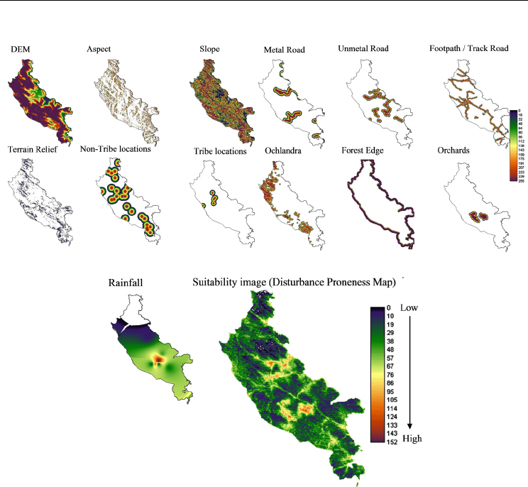
2.5.2 Spatial drivers of land cover change
Thirteen carefully chosen drivers (Fig. 6) including altitude, slope, aspect, proximity to
protected area (PA) boundary, settlement, tea and coffee plantation, road and footpath,
rainfall intensity and existing sites of Ochlandra reeds were integrated using appropriate
fuzzy set membership functions into a single suitability image (Eastman, 2003). This
suitability image was then used in GEOMOD to model change from 1973 to 1990, 1990 to
2004 and then from 2004 to 2020. The driver maps used for each calibration run are added
together to create a (disturbance proneness area) suitability map (Fig. 6). GEOMOD uses this
map of ranked potentials, or likelihoods, to simulate deforestation at a third point in time,
the results of which are validated against the actual map of that same time period to test
how well the drivers did in predicting the spatial pattern of deforestation. This ‘test’ is
called the validation process and is discussed further below.
Evaluating Biodiversity and Spatial Simulation
of Land-Cover Change in the Tropical Region of Western Ghats, India
123
Fig. 6. List of potential spatial drivers generated using multi-criteria decision support to
generate suitability image for the evergreen forest change modeling of KMTR, Southern
Western Ghats, Tamil Nadu, India.
2.5.3 Validation
To validate the results created by GEOMOD, the actual evergreen map at a known point of
time is compared with the predicted evergreen map of that same time, based on analysis of
the pattern at an earlier time point using the “Validation” tool available in the IDRISI
module. In the past, measures of the ‘goodness of fit’ commonly were performed by using a
simple percent-correct measure or, at best, a multiple-resolution percent-correct measure
(Costanza, 1989; Hall et al., 1995), but this provides little assessment of a model’s ability to
predict the correct quantity of change versus its ability to identify the correct location of
change (Pontius & Batchu, 2003; Pontius & Pacheco, 2004). Spatial measures of ‘goodness of
fit’ have been developed, that measures the degree to which a simulated map agrees with a
reality map with respect to both location (Kappa-for-location) and quantity of cells correct
(Kappa-for-quantity).

Research in Biodiversity – Models and Applications
124
3. Results
3.1 Vegetation types
The changes in the vegetation cover based on digital classification of Landsat-MSS and IRS
LISS-III data shows a significant decrease of evergreen forest mostly to semi-evergreen forest
types (Table 1a). Of the total area covered by natural vegetation (857sq.km) the evergreen and
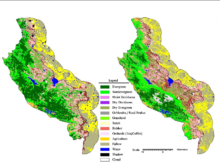
semi-evergreen forest occupied 60% of the area. The map showing multi-temporal vegetation
and land-cover classification is given in Fig. 7. In 1973, evergreen forests constituted 316sq.km,
followed by semi-evergreen having 194sq.km. In 2004 the evergreen forest had diminished to
188sq.km (i.e. 40% loss of land-cover), whereas semi-evergreen forest gained by 36% to
265.1sq.km. The grassland covering of 73sq.km is largely distributed among the Kodayar,
Manjamparai and adjoining areas of the Agasthyamalai region. The area under grassland has
shown a significant increase of ca. 166% during the period 1973 – 2004.
S.No Types 1973 2004
1 Evergreen 316.72 188.49
2 Semi-evergreen 194.40 265.10
3 Moist deciduous 143.59 132.02
4 Dry deciduous 38.95 98.30
5 Dry evergreen 136.14 61.55
6 Grassland 27.36 73.14
Subtotal 857.16 818.60
7 Shrubs 1.11 16.01
8 Ochlandra 13.56 23.74
9 Orchards 2.33 16.42
10 Fallow/barren 10.04 9.86
11 Water 15.22 16.86
12 Shadow 6.97 2.50
13 Cloud 1.07 3.46
907.46 907.46Grand total
Phenelogical types
Other landcover types
Table 1a. Vegetation and land-cover distribution in KMTR, Southern Western Ghats, Tamil
Nadu, India. for the years1973 and 2004 using satellite imagery.
Evaluating Biodiversity and Spatial Simulation
of Land-Cover Change in the Tropical Region of Western Ghats, India
125
Fig. 7. Vegetation and land cover classification map for the study region (1973 & 2004) of
KMTR, Southern Western Ghats, Tamil Nadu, India.
3.2 Spectral analysis
The spectral reflectance of the evergreen forest in the NIR band of 1973 (60±2 SD) is quite
similar to the spectral reflectance of the 2004 data having 76±4 SD. The semi-evergreen patch
showed a spectral reflectance of 92±3 SD from the 1973 data, while the semi-evergreen
reflectance in 2004 was 135±4 SD (Fig. 3). The evergreen patches which had been converted
to semi-evergreen patches during 2004 showed a reflectance of 130±5 in the NIR. The SWIR
band of IRS P6 LISS-III has shown that the intact evergreen and disturbed evergreen patches
can be distinctly differentiated from this reflectance value.
3.3 Land-cover change analysis
Change detection analysis was performed was performed on the data from two time periods
– 1973 and 2004 – and change matrix is given in Table 1b. Major changes in the land-cover of
KMTR has been the change from evergreen to semi-evergreen forest type (121.74km
2
),
constituting ca. 38% of the total land-cover changes, evergreen to reeds brake (Ochlandra)
(6.64km
2
), and evergreen to orchards (4.87km
2
). Conspicuous changes in semi-evergreen
forest type were to grassland (17.64km
2
), Ochlandra (10.72km
2
) and orchards (6.76km
2
). It is
observed that the changed vegetation cover is mostly in patch sizes of either 100ha or more,
or in the size of 10 –50ha.
Research in Biodiversity – Models and Applications
126
Evergreen
Semi-
evergreen
Others
Total
Evergreen 166.31 121.74 28.67 316.72
Semi-evergreen 21.02 119.19 54.20 194.40
Others 1.16 24.17 371.02 396.34
Total 188.49 265.10 453.88 907.46
1973
2004
Table 1b. Change matrix for KMTR between 1973 and 2004, Southern Western Ghats, Tamil
Nadu, India.
3.4 Phytodiversity change analysis
To understand the changes of evergreen to semi-evergreen patches in terms of
phytosociological data, a total of 95 sample plots (0.1ha each) were grouped into change (40
plots) and no-change areas (55 plots) for identification of predominant species, percentage of
endemic and edge species. Differences in species composition based on predominant species
for change and no-change area are given in Table 2. Of the total 266 tree species in the no-
change area 38% were endemic and 25% were edge species. While in the change areas
having 249 tree species 31% were endemic, 31% belonged to the edge species. Among the
saplings in the no-change area (170 species) 44% were endemic and 19% were edge species,
in the change area (146 species) 34% were endemic and 29% were of the edge species.
No-Change area Change area
No. of plots 55 40
No. of Species 266 249
No. of Individuals 3340 1977
Stand density (ha
-1
)
607 494
Basal area (m
2
ha
-1
)
54.39 44.11
No. of endemic species / individuals 100 (38) / 1274 (38)* 78 (31) / 737 (37)
No. of edge species / individuals 66 (25) / 294 (9) 78 (31) / 296 (15)
No. of plots 51 33
No. of Species 170 146
No. of Individuals 863 535
Stand density (ha
-1
)
169 162
Basal area (m
2
ha
-1
)
0.47 0.42
No. of endemic species / individuals 75 (44) / 399 (46) 49 (34) / 155 (29)
No. of edge species / individuals 33 (19) / 60 (7) 42 (29) / 142 (27)
* Figures in bracket indicates percentage
Saplings (Tree and Shrub) ≤ 30 cm
Tree Species
30 cm
Table 2. Consolidation of phytosociological analysis in no-change and change area plots in
KMTR, Southern Western Ghats, Tamil Nadu. India.

Evaluating Biodiversity and Spatial Simulation
of Land-Cover Change in the Tropical Region of Western Ghats, India
127
The first three predominant species composition in the no-change area is largely composed
of Cullenia exarillata – Myristica dactyloides – Mesua ferrea when compared to the change areas
having Cullenia exarillata – Dimocarpus longan – Kingiodendron pinnatum (Table 3a). The
percentage of endemic species in the change area is greater by 7% and edge species lesser by
7% when compared to the no-change area. Interestingly in change areas large levels of
secondary successional species were noticed, which includes Epiprinus mallotiformis,
Macaranga peltata, Mallotus philippensis, Scolopia crenata, and Schleichera oleosa. Regeneration
trend in no-change areas showed a dominance of Antidesma menasu, Cinnamomum
malabatrum and Mesua ferrea while in change areas Dimocarpus longan, Mallotus philippensis
and Mesua ferrea species are seen to be dominant. Further, the dominants in the semi-
evergreen are again Dimocarpus longan, Mallotus philippensis and Mesua ferrea indicating that
the evergreen patch is gradually being changed to semi-evergreen (Table 3b). Species
similarity between no-change and change areas was found to be at 68%.
Similar trends on endemic and edge species have been noticed in the no-change and change
areas. No-change areas of endemic tree species showed dominance in Mesua ferrea, Aglaia
b
ourdillonii and Hopea utilis, while for saplings it was Mesua ferrea, Cinnamomum malabatrum
and Cryptocarya bourdillonii (Table 4a). In the case of edge tree species the dominant ones
were Macaranga peltata, Mallotus philippensis and Memecylon edule while among saplings
Mallotus philippensis, Macaranga peltata and Olea dioica were dominant (Table 4b).
Species no-change area IVI Species change area IVI Semievergreen IVI
Cullenia exarillata 22.51 Cullenia exarillata 20.17 Dimocarpus longan 31.58
Myristica dactyloides 9.88 Dimocarpus longan 20.10 Mesua ferrea 15.00
Mesua ferrea 9.72 Kingiodendron pinnatum 8.18 Canarium strictum 12.18
Agrostistachys meeboldii 9.64 Mesua ferrea 7.83 Diospyros paniculata 11.04
Syzygium gardneri 7.74 Filicium decipens 6.86 Filicium decipens 10.93
Dimocarpus longan 7.11 Hopea parviflora 5.88 Holigarna arnottiana 10.44
Calophyllum austroindicum 6.41 Vitex altissima 5.60 Garcinia gummi-gutta 8.40
Aglaia bourdillonii 6.23 Hopea utilis 5.26 Kingiodendron pinnatum 8.06
Antidesma menasu 5.72 Myristica dactyloides 5.22 Madhuca indica 7.33
Hopea utilis 5.26 Diospyros foliolosa 4.25 Mallotus philippensis 6.98
Acronychia pedunculata 5.17 Macaranga peltata 4.23 Hopea parviflora 6.61
Artocarpus heterophyllus 4.98 Agrostistachys meeboldii 4.18 Gordonia obtusa 6.44
Xanthophyllum flavescens 4.86 Mallotus philippensis 3.75 Wrightia tinctoria 6.02
Palaquium ellipticum 4.78 Syzygium mundagam 3.52 Schleichera oleosa 5.67
Mangifera indica 4.66 Pterospermum diversifolium 3.40 Diospyros sp. 5.43
Gomphandra coriacea 4.27 Scolopia crenata 3.24 Bischofia javanica 4.85
Cryptocarya bourdillonii 4.04 Syzygium gardneri 3.19 Pterospermum xylocarpum 4.81
E
piprinus mallotiformis 4.00 Cinnamomum malabatrum 3.00 Persea macrantha 4.72
Pterospermum xylocarpum 3.82 Tricalysia apiocarpa 2.97 Myristica dactyloides 4.72
Cinnamomum malabatrum 3.62 Diospyros paniculata 2.95 Acronychia pedunculata 4.52
Table 3a. Tree species composition in no-change and changes areas of the evergreen and
semi-evergreen forests in KMTR, Southern Western Ghats, Tamil Nadu, India.

Research in Biodiversity – Models and Applications
128
Species no-change area IVI Species change area IVI Semievergreen IVI
Antidesma menasu 12.09 Dimocarpus longan 25.19 Dimocarpus longan 13.00
Cinnamomum malabatrum 10.61 Mallotus philippensis 13.20 Mallotus philippensis 12.01
Mesua ferrea 10.61 Mesua ferrea 8.07 Mesua ferrea 10.00
Cullenia exarillata 9.62 Hydnocarpus alpina 7.89 Macaranga peltata 9.84
Cryptocarya bourdillonii 8.79 Nothopegia beddomei 6.49 Hydnocarpus alpina 9.23
Syzygium gardneri 8.75 Xanthophyllum flavescens 5.90 Pavetta hispidula 8.74
Myristica dactyloides 7.55 Macaranga peltata 5.80 Epiprinus mallotiformis 8.41
Agrostistachys meeboldii 6.94 Meliosma pinnata 5.72 Chomelia asiatica 7.84
Xanthophyllum flavescens 6.81 Pavetta hispidula 5.24 Scolopia crenata 7.00
Palaquium ellipticum 6.33 Mallotus stenanthus 5.21 Acronychia pedunculata 6.81
Neolitsea scorbiculata 5.82 Canthium angustifolium 5.01 Kingiodendron pinnatum 6.01
Nothopegia heyneana 5.17 Kingiodendron pinnatum 5.01 Filicium decipens 5.71
Gomphandra coriacea 5.02 Olea dioica 4.87 Persea macrantha 5.11
Mallotus stenanthus 4.77 Holigarna arnottiana 4.65 Olea dioica 4.86
Epiprinus mallotiformis 3.91 Filicium decipens 4.4
2 Holigarna arnottiana 4.15
Hydnocarpus alpina 3.84 Eugenia thwaitesii 4.11 Canthium angustifolium 3.95
Cinnamomum verum 3.83 Eugenia calcadensis 4.03 Meliosma pinnata 3.11
Litsea mysorensis 3.67 Chomelia asiatica 3.82 Xanthophyllum flavescens 2.99
Litsea floribunda 3.67 Epiprinus mallotiformis 3.77 Nothopegia beddomei 2.11
Octotropis travancorica 3.64 Scolopia crenata 3.68 Diospyros paniculata 2.00
Table 3b. Species composition in tree and shrub saplings of no-change and changes areas of
the evergreen and semi-evergreen forests in KMTR, Southern Western Ghats, Tamil Nadu,
India.
No-chan
g
eChan
g
e No-chan
g
eChan
g
e
Mesua ferrea 116 53 Mesua ferrea 34 12
Aglaia bourdillonii 107 16 Cinnamomum malabatrum 34 2
Hopea utilis 80 37 Cryptocarya bourdillonii 27 1
Litsea floribunda 50 1 Nothopegia heyneana 21 5
Cryptocarya bourdillonii 44 1 Palaquium ellipticum 21 0
Palaquium ellipticum 43 15 Mallotus stenanthus 15 9
Cinnamomum malabatrum 36 29 Octotropis travancorica 11 1
Drypetes confertiflorus 36 1 Litsea mysorensis 10 2
Calophyllum austroindicum 34 1 Nothopegia beddomei 910
Symplocos macrocarpa 33 8 Aglaia bourdillonii 92
Species
Trees ≥ 30 cm
Species
Sapling ≤ 30 cm
Table 4a. Predominant endemic species and its individuals in no-change and change areas of
the evergreen forest in KMTR, Southern Western Ghats, Tamil Nadu, India.