Roy K.K. Potential theory in applied geophysics
Подождите немного. Документ загружается.

3.14 Gravity Field of the Earth 69
Since
θ
i
=tan
−1
z
i
x
i
, θ
i+1
=tan
−1
z
i+1
x
i+1
ψ
i
=tan
−1
z
i+1
− z
i
x
i+1
− x
i
and
a
i
=PC
/
=QC
/
=x
i+1
− z
i+1
Cot ψ
i
=x
i+1
+z
i+1
z
i
− z
i+1
x
i+1
− x
i
. (3.93)
Therefore the final expression for the gravitational anomaly for a prism with
nnumberoffaceisgivenby
∆g
ρ
=2Gρ
n
i=1
x
i
z
i+1
− z
i
x
i+1
(x
i+1
− x
i
)
2
+(z
i+1
− z
i
)
2
(x
i+1
− x
i
)(θ
i
− θ
i+1
)
+(z
i+1
− z
i
)ln
r
i+1
r
i
. (3.94)
3.14 Gravity Field of the Earth
Gravity field of the earth is a global naturally existing field which attracts any
mass having a definite density and weight towards the centre of the earth. One
can measure this field or it’s variations on the surface of the earth, in the air,
in the ocean, inside a borehole or inside a mine. Thus the different branches of
gravity measurements, viz., aerogravity, marine gravity, b orehole gravity and
surface gravity have developed. In surface gravity also (i) survey for geodesy,
(ii) survey for crustal studies (iii) survey for oil exploration and (iv) survey
for mineral exploration have altogether different dimensions. That is why in
a square grid gravity survey the distance between the two consecutive gravity
stations can be around 100 km for geodetic survey to 10 meters for mineral
survey.
Normal gravity field of the earth varies from 978.0327 gal at the equator to
981.2186 gal at the pole (Wilcox 1989). Point to point variation of the gravity
field is termed as gravity anomaly ∆g and its’ unit is milligal.
Gravity data need a few corrections be fore they can be used for routine
interpretation using forward modelling and inversion. The corrections are
(i) Free air correction
(ii) Bouguer correction
(iii) Te rrain correction
(iv) Latitude correction
(v) Tidal correction
(vi) Isostatic correctiom
(vii) Drift correction
70 3 Gravitational Poten tial and Field
3.14.1 Free Air Correction
Earth, s normal gravity field varies inversely as the square of the distance.
Therefore, hills and valleys bring variations in the earth’s gravitational force
of attraction. Gravity at a height ‘h’ at any latitude can be represented by
truncated Taylor’s series expansion
G(R + h) = g(R) + h∂g(R)/∂R + ············ (3.95)
It generates the free air correction as
G(R + h) = g(R) −(0.30855 + .00022 cos2ψ )h + 0.073 ×10
−6
h
2
−−− (3.96)
where h is in meters and the gravity field is in milligal. For routine free air
correction 0.3086 h milligal is added to the gravity value. It only depends upon
the distance of the point of observation from the centre of the earth.
3.14.2 Bouguer Correction
Bouguer correction accounts for the attraction of the assumed plate at an
assumed point in a datum plane from the point of observation on the surface.
Through Bouguer correction, all the gravity data are brought back to the
same datum plane. Earth materials below the observation point will generate
an additional force of attraction at the datum point which was not taken
care of in free air correction. The earth materials present below the point
of observation and ab ove the assumed datum plane is given an approximate
shape of a plate of certain thickness and infinitely large radius. For reducing
all the gravity data to the same datum plane the Bouguer correction is always
substracted from the gravity data. It’s value is 0.04188 ρ where ρ is the density
oftheslab(seeSect.3.9)
3.14.3 Terrain Correction
Rugged topography in a hilly terrain with rapid variation in elevation causes
an extra correction to be added. Terrain correction is always added bo th
for hills and valleys because the presence of positive a nd negative masses
will always align the force of attraction vector in the same direction. Mass
excess in the hill and mass deficiency in the valley will dictate the quan-
tum of correction to be applied. Details are available in Dobrin and Savit
(1988).
3.14.4 Latitude Correction
Spheroidal shape of the earth with its equatorial bulge and centrifugal force
for rotation of the earth around it’s axis and revolution of the earth around
3.14 Gravity Field of the Earth 71
the sun in its orbit generates the latitude correction. It’s latitude dependence
is expressed by the equation(Heiskanen and Vening Meinsz 1958)
g(ψ) = 978.049(1 + 0.0052884Sin
2
ψ −0.0000059Sinψ (3.97)
where‘ψ’ is the latitude on the surface of the earth. This is the international
gravity formula. The radius of the spheroidal earth is given by
R(ψ) = 6378.388(1 − 0.0033670Sin
2
ψ +0.0000071Sin
2
2ψ). (3.98)
The normal gravity formula for geodetic reference system is as follows
g(ψ) = 978.0327(1 + 0.0053024 Sin
2
ψ −0.00000071 Sin
2
2ψ). (3.99)
For routine latitude correction needed for geodetic survey as well as for surveys
related with crustal studies the latitude correctio n used is ≈ 1.307 Sin2ψ.
3.14.5 Tidal Correction
Sensitive gravimeters respond to the position of the sun and moon with respect
to the earth and the values of g varies with the tides in the ocean. It may be
a fraction of a milligal but it is measurable.
3.14.6 Isostatic Correction
Isostatic correction originated due to the presence of lateral variation of den-
sity within the earth, s crust. After the said corrections are applied, the
Bouguer anomaly for particular reference plane should have been zero in large
scale mapping and keeping aside the local variations in densities .In re alities
it is was observed that negative Bouguer anomaly exists near the mountains
and positive anomaly exits near the oceans.
Two scientists named G.B. Airy and J.H. Pratt proposed two different
models for the crust. Airy’s model suggests that crust is thick near the moun-
tains and mountains have roots and it is thiner below the ocean bottoms and
here the crust has antiroots. The density of the crust is assumed to be the
same. Pratt assumed a variable density model and this variation in density
has direct relation with the elevation of the ground from the mean sea level.
Depth of the ocean floor from the mean sea level causes increase in density.
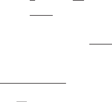
Figures 3.23a.b show the Airy and Pratt’s isostatic mo dels.
Isostatic correction is needed only for geodetic survey as well as for surveys
related to crustal studies. For routine exploration survey only free air, Bouguer
and terrain corrections are necessary. Drift correction is an instrument based
correction. Round the clock reading at one point can give the idea about drift
correction to be added or subtracted.
72 3 Gravitational Poten tial and Field
Fig. 3.23. (a) A iry’s isostatic model; (b) Pratt’s mode
3.15 Units
G=cm/gmsec
2
(CGS unit)
=m/kgsec
2
(MKS unit)
g=cm/ sec
2
and gal
∆g = milligal(10
−3
gal)
ρ =gms/cc.
3.16 Basic Equation
The basic equations for the gravitational field are
(i) g=−grad φ
g
(3.100)
where φ
g
is the scalar gravitational potential.
3.16 Basic Equation 73
(ii) Curl g = 0 (3.101)
because the force of attraction is along the line joining the two masses.
(iii) div grad φ
g
= ∇
2
φ
g
=4πGm (3.102)
when the region contains the mass. It satisfies Poisson’s equation. In a source
free region ∇
2
φ
g
= 0 and it satisfies Laplace’s equation.

4
Electrostatics
In this chapter a brief introduction on electrostatics is given. Coulomb’s law,
electrostatic potential, electrical permittivity, electrical fluxes and displace-
ment vector, Gauss’s theorem on total normal induction, electrostatic dipole
potential and field, Lapla ce and Poisson’s equatio n s,. electrostatic energy,
boundary conditions and basic e q u ations in electrostatics are gi ven.
4.1 Introductio n
It was known to the people for more than three centuries that if an insulator is
rubbed with a cloth it acquires a special property of attracting other objects.
It was said that the body got charged. As early as 1785 Coulomb first quan-
titatively measured the force of attraction or repulsion. It was observed that
when a g lass rod is rubbed with a silk cloth, it acquires positive charge. Simi-
larly when an amber rod is rubbed with a black cotton cloth negative charge
originates. These positive and negative charges are arbitrary convensions. Sim-
ply these charges are found to be of opposite polarities. Electrostatics deals
with these immovable electric charges of opposite or same signs a nd the fields
created by these charges. The energy spent to rub an amber or a glass ro d
is partly converted into electrical e nergy and partly into heat energy due to
friction. This electrical energy ap pears in the form of electrical charges. It is
observed that the number of charges in the glass rod is exactly same as that
in the silk cloth. It proves the total conservation of charges and energy remain
the same. Free energy (which can be easily converted into work) in any ther-
modynamic system was used to separate these two ty pes of charges p resent
in a body. They originate from an uncharged neutral b ody. Like charges repel
and unlike charges attract. These electric charges remain static and generate
electric field. The subject electrostatics is one of the most fundamental sub-
jects in potential theory. Because some of the most fundamental concepts and
equations, used in electromagnetic theory, came from electrostatics.
76 4 Electrostatics
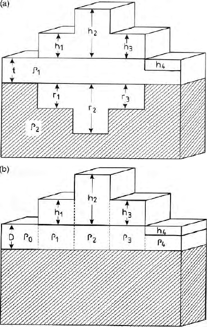
Fig. 4.1. Coulomb force of attraction between a positive and a negative charge
separated by a distance r
4.2 Coulomb’s La w
Coulomb’s law states that two point charges q and q
′
separated by a distance
‘r’ will have (i) a force of attraction or repulsion directly prop ortional to the
product of the two charges and inversely proportional to the squar e of the
distance, (ii)the force of attraction or repulsion will be along the line joining
the two charges(Fig. 4.1), (iii) the constant of proportionality k = 1/4π ∈,
where ∈ is the electrical permittivity of t he medium (Sect. 4.4) (iv) like charges
repel and unlike charges attract. The expression for electrostatic force is given
by
F=k
qq
′
r
2
. (4.1)
This is known as the Coulomb’s law of force and k is a constant. Units of q,r
and F are r espectively in coulomb, meter and Newton,.
4.3 Electrostatic Potential
Potential at a point in an electrostatic field is the amount of work done to
bring an unit charge from infinity to that point. Since work done = force x
distance, we can write
Workdone = −
R
∞
F
r
d
dl. (4.2)
Since
F=
q
4π ∈ r
2
for an unit charge. = −
R
∞
q
4π ∈ r
2
dr. =
1
4π ∈
.
q
r
(4.3)
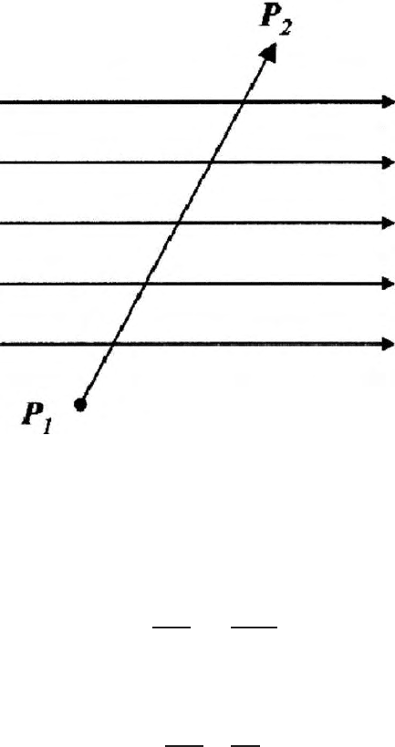
Therefore the potential at a point P
2
at a distance r from a single charge q at
P
1
is given by
1
4π ∈
.
q
r
(Fig. 4.2). The potential φ
=
1
4π ∈
q
r
has only magnitude
and no direction and therefore it is a scalar potential. Potential at a point is
independent of the path followed.
The p otential at a p oint P due to numb er of charges q
1
, q
2
, q
3
... situated
at distances r
1
, r
2
, r
3
is given by
φ =
1
4π ∈
q
1
r
1
+
q
2
r
2
+
q
3
r
3
+ .....
. (4.4)
4.4 Electrical Permittivit y and Electrical Force Field 77
Fig. 4.2. Work done for movement of the unit charge in the field
If there i s a continuous distribution of charge thro ughout a region instead of
being located at discrete points, the region can be divided into elements of
volume ∆v. Then each ∆v contains charge ρ∆v where ρ is the volume density
of charge in the volume element. The potential at a point is given by
φ =
1
4π ∈
.
∞
i=1
ρ
i
∆v
i
r
i
(4.5)
where r
i
is the distance of the ith volume element from P. When the size of
these volume elements become infinitesimally small
φ =
1
4π ∈
ρdv
r
. (4.6)
4.4 Electrical Permittivity and Electrical Force Field
If two opposite faces of an insulator (Fig. 4.3) are charged with potential
difference φ applying an external electric field, the charges on the two opposite
faces will be given by
φC = q (4.7)
where C is the capacitance of a dielectric and φ is the voltage across the two
faces. Capacitance between the two plates can be defined as the charges needed
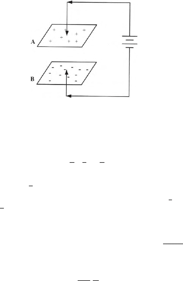
78 4 Electrostatics
Fig. 4.3. Charging of a dielectric (capacitance) between the two opposite faces
for unit potential difference between the two opposite faces of a capacitor. Unit
of capacitance is farad. This name was chosen to honour Micheal Faraday. The
unit farad = 1 coul/volt. More practical units are microfarad (1 µf=10
−6
f)
and picofarad (1pf = 10
−12
f). Equation (4.7) can be written as,
C.
l
A
.
φ
l
=
q
A
(4.8)
Here l is the distance b etween the two opposite faces of a capacitor.
where ∈=C
ℓ
A
. The capacitance of a body per unit length and unit
cross section is termed as electrical permittivity or electrical capacitivity of a
medium. Potential per unit width of the capacitor is the field
ESoE =
φ
l
and
D
=
q
A
is the charge per unit area. It is termed as the dielectric flux den-
sity. It is also termed as the displacement vector. Its unit is Coulomb/meter
2
.
In a vacuum ∈=∈
0
=8.854 × 10
−12
farad/meter When an electric field is
applied between two opposite faces of a dielectric material, potential gener-
ated between the two opposite faces of the dielectric depends upon capacitance
of the dielectric. Dielectric constant is given by ∈
k
=∈
0
∈
r
where ∈
0
=
1
36πx10
9
and is the free space electrical permittivity of the medium. ∈
r
is the relative
electrical permittivity of the body with respect to the free space value. The
electrostatic field due to a p oint charge is given by,
E =
1
4π ∈
.
q
r
3
.r (4.9)
The field lines for a point source (positive charge) and sink (negative charge)
are radial (Fig. 2.3) in a homogeneous and isotropic dielectric and the equipo-
tential surfaces will be spherical. The direction of force is along the line joining
the two charges irresp ective of polarity of the charges.