Wai-Fah Chen.The Civil Engineering Handbook
Подождите немного. Документ загружается.

31-12 The Civil Engineering Handbook, Second Edition
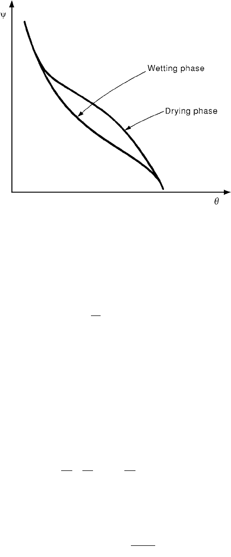
The energy possessed by the fluid due to soil suction forces y(q) of a soil is a function of volumetric
soil moisture q and is called the capillary potential. The ratio of the volume of water in a soil volume is
the moisture content q. The capillary potential y(q) is related to the piezometric head h as in Eq. (31.17),
where z is the elevation head, h is the piezometric head and p
c
/g is the pressure head.
(31.17)
p
c
is negative and hence p
c
/g is called the suction head. The capillary potential, for the same soil moisture
q, depends on whether the soil is in the wetting or drying phase. For the same q, y(q) is higher when
the soil is drying than when it is wetting (Fig. 31.7)
Infiltration Models
Considering only the flow in the vertical direction z, the infiltration of water is governed by Eq. (31.18),
where t is the time, D
z
(q) is the diffusivity and K
z
(q) is the hydraulic conductivity in the z direction
(Bras, 1990).
(31.18)
The diffusivity D
z
(q) is given by Eq. (31.19), where the hysterisis effects of y(q) (Fig. 31.7) are ignored
and y(q) is considered as a single valued function of q.
(31.19)
To simplify Eq. (31.18), K
z
(q) is considered to be a constant or that it is small in comparison with
D
z
(q) (∂q/∂z). If it is further assumed that D
z
(q) is constant and equal to D, Eq. (31.18) reduces to the
diffusion Eq. (31.20). Assuming a semi-infinite soil system and the boundary conditions in Eq. (31.21),
Eagleson (1970) shows that the solution of Eq. (31.20) is given by Eq. (31.22)
FIGURE 31.7 Capillary potential vs. soil moisture.
h
p
zz
c
=+=
()
+
g
yq
∂
∂
=
∂
∂
()
∂
∂
+
()
È
Î
Í
˘
˚
˙
q
q
q
q
tz
D
z
K
zz
zz
DK
qq
yq
q
()
=
()
∂
()
∂
© 2003 by CRC Press LLC

Surface Water Hydrology 31-13
(31.20)
(31.21)
(31.22)
where
The solution in Eq. (31.22) is applicable at the soil surface (z = 0). The variable l in Eq. (31.22) is a
characteristic length dependent on z. Equation (31.22) is a form of the infiltration equation derived by
Horton (1939, 1940). Philip (1960) presented an analytical solution to the infiltration equation when
the initial and boundary conditions correspond to those in Eq. (31.21) with q
o
equal to porosity n. An
approximate form of Philip’s solution is given in Eq. (31.23) where S, called the sorptivity, and K are
parameters related to diffusivity, hydraulic conductivity and initial soil moisture.
(31.23)
Empirical Infiltration Equations
Although there is a strong theoretical basis from which infiltration equations such as Horton’s and Philip
equations are derived, there are numerous empirical equations in use. Most of these are based on the
observation that there is an initial infiltration rate f
o
, which depends on the soil type and antecedent
moisture conditions, which decreases to infiltration capacity f
c
under a supply rate i
s
which is higher than
f
o
. The third parameter besides f
o
and f
c
is the rate of decay. More popular of the empirical infiltration
equations are considered below. These models have also been derived by using a systems approach. Quite
often, the supply rate is smaller than the infiltration capacity. In such a case all the rainfall supply is
assumed to infiltrate into the soil until such time when the total rainfall and the infiltration depths are
the same. The time at which the infiltration and rainfall depths are the same is called the ponding time.
Horton Equation
Horton’s equation is given in Eq. (31.24), which is the same as Eq. (31.22) with Dl
2
= k.
(31.24)
The cumulative infiltration F
p
(t) corresponding to Eq. (31.24) is given by Eq. 31.25). If a constant
rainfall rate i
s
is assumed, the ponding time t
p
is given by Eq. (31.26).
(31.25)
(31.26)
∂
∂
=
∂
∂
qq
t
D
z
2
2
q
q
q
=
£=
=>
Ï
Ì
Ô
Ó
Ô
i
o
z;t
z;t
00
00
pc oc
-
Dl
t
ffff
e
=+ -
()
-
2
pc
po
o
ff
z , t
ff
z,
t
.
===•
===
0
00
p
/
f
tS
t
K
()
=+
-
1
2
12
pcoc
kt
f
t
fff
e
()
=+ -
()
-
p
c
oc
F
f
t
ff
k
=+
-
()
p
s
o
s
c
oc
s
c
t
i
k
f
i
f
ff
i
f
=-+
-
-
Ê
Ë
Á
ˆ
¯
˜
È
Î
Í
Í
˘
˚
˙
˙
1
ln
© 2003 by CRC Press LLC

31-14 The Civil Engineering Handbook, Second Edition
Phillip’s Infiltration Equation
Phillip’s equation is not an empirical equation. The cumulative infiltration and the time of ponding for
rainfall of constant intensity i
s
for this equation are given by Eq. (31.27) and Eq. (31.28)
(31.27)
(31.28)
Green and Ampt Model
Green and Ampt (1911) proposed an infiltration model that is given by Eq. (31.29), where the cumulative
infiltration is given by Eq. (31.30)
(31.29)
(31.30)
In Eqs. (31.29) and (31.30), K is the hydraulic conductivity, Dq is the difference between the soil
porosity n and moisture content q, y is the soil suction head. In practice, the hydraulic conductivity K,
and the soil suction head y and the porosity are obtained from published sources such as Rawls et al.
(1983). Instead of using Dq, it is expressed in terms of effective porosity q
e
and effective saturation S
e
as
in Eq. (31.31).
(31.31)
Effective porosity q
e
is the difference between soil porosity and the residual moisture content q
r
after
it has been thoroughly drained (Eq. [31.32]).
(31.32)
The effective saturation s
e
is given by Eq. (31.33).
(31.33)
q
e
values are listed for different soils by Rawls et al. (1983). Consequently by knowing the effective
saturation s
e
of the soil and the other parameters listed by Rawls et al., (1983), the Green and Ampt model
may be used to estimate infiltration.
31.5 Surface Runoff
Process and Measurement
An area that drains into a stream at a given location via a network of streams is called a watershed.
Rainfall that falls on a watershed fills the depression storage, which consists of storage provided by natural
depressions in the landscape, it is temporarily stored on vegetation as interception and it infiltrates into
the soil. After these demands are satisfied, water starts flowing over the land and this process is called
overland flow. Water that is stored in the upper soil layer may emerge from the soil and join the overland
flow. The overland flow lasts only for short distances after which it is collected in small channels called
rills. Flows from these rills reach channels. Flow in channels reaches the mainstream.
p
/
F
S
t
At=+
12
ps
ss
s
tSi
AiiA,
i
A=-
()
-
()
>
2
2
22
p
f
K
Ft
=
()
+
Ê
Ë
Á
ˆ
¯
˜
yqD
1
p
p
F
Kt
F
=+ +
Ê
Ë
Á
ˆ
¯
˜
yq
yq
D
D
ln 1
Dq q=-
()
1 s.
ee
er
n
qq
=-
e
r
r
s
n
=
-
-
qq
q
© 2003 by CRC Press LLC
Surface Water Hydrology 31-15
When rainfall is of low intensity, the overland-rill-channel flow sequence may not occur. In such cases,
only the land near the streams contributes to the flow. These areas are called variable source or partial
areas. Only a small area of watersheds contribute to stream flows in a humid region.
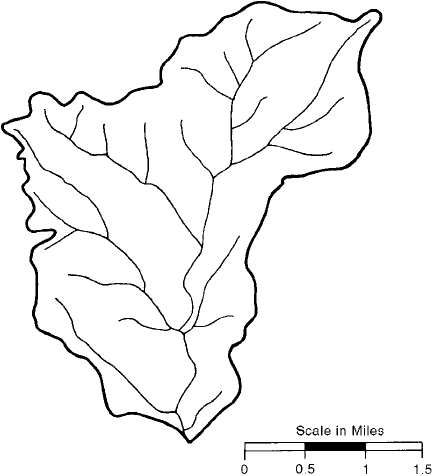
The transformation of rainfall to runoff is affected by the stream network, by precipitation, by soil,
and land use. A watershed consists of a network of streams as shown in Fig. 31.8. Channels that start
from upland areas are called the first order channels. Horton (1945) developed a stream order system,
in which when two streams of order i join together the resulting stream is of order i + 1. There are several
laws of stream orders developed by Horton (1945).
If a watershed has N
i
streams of order i and N
i+1
of order i + 1, the ratio N
i
/N
i+1
is called the bifurcation
ratio R
B
, the ratio of stream lengths L
i+1
and L
i
belonging to orders i+1 and i the ratio of stream lengths
R
L
, and the ratio of areas R
A
and R
A+1
the area ratio. These ratios vary over a small range for each
watershed. The drainage density D of a watershed is the ratio of total stream length to the area of the
watershed. Higher values of D represent a highly developed stream network and vice versa. Plots of L
i
,
A
i
and N
i
against the order i for an Indiana watershed are shown in Fig. 31.9.
The second factor that significantly affects runoff is rainfall. The spatial and temporal rainfall distri-
bution and the history of rainfall preceding a storm affect runoff from watersheds. Rainfall is usually
treated as a lumped variable because spatial rainfall data are not commonly available.
The third factor that affects runoff characteristics is the land use. As watersheds are changed from
rural to urban or from forested to clear cut condition, runoff from these watersheds changes drastically.
For example, when a rural watershed is urbanized, the peak discharges from the urban watershed may
be more than 100% higher than runoff from the rural watershed for the same rainfall. The time to peak
discharge would also be considerably shorter and the runoff volume much larger in urban watersheds
compared to rural watersheds.
A plot of variation of discharge with time is called a hydrograph. A hydrograph may have different
time scales such as hourly, daily, etc. Hydrographs that result from storms are called storm hydrographs
(Fig. 31.10). A typical storm hydrograph may have a small flow before the discharge increases on the
rising limb, reaches a peak and decreases along the recession limb. The flow that exists before the
FIGURE 31.8 Drainage map of Bear Creek Basin, Indiana.
© 2003 by CRC Press LLC
31-16 The Civil Engineering Handbook, Second Edition
hydrograph starts rising is contributed by the groundwater and is called the baseflow and is not considered
to be generated by the storm.
Streamflows are measured by using current meters. A stable cross section of the stream is selected and
divided into a number of sections. Velocities in each section are measured and averaged. The product of
the average velocity and the area of the section give the discharge in that section. Sum of discharges
measured in different sections gives the discharge in the stream at that cross section.
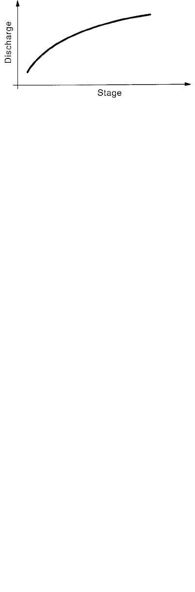
Discharges are uniquely related to the water levels in stable stream channels. A plot of discharges
against water level elevations, called river stages, is called a rating curve of a stream at a gaging station
(Fig. 31.11). Once a rating curve is established for a river cross section, only the stages are measured and
discharges are computed by using the rating curve. Discharges are recorded continuously or at finite time
intervals. They can also be transmitted electronically to a central location where they are recorded for
dissemination. Details about river gaging are found in Rantz et al. (1982).
Unit Hydrographs
One of the common and important problems in hydrology is the estimation of runoff hydrographs that
result from rainfall. These hydrographs are needed for various purposes such as design of drainage and
hydraulic structures and flood flow forecasting. Unit hydrograph theory is commonly used to estimate
runoff hydrographs.
FIGURE 31.9 Horton’s ratios for Bear Creek Basin, Indiana.
FIGURE 31.10 A single peaked hydrograph.
© 2003 by CRC Press LLC
Surface Water Hydrology 31-17
Although surface runoff has several components such as baseflow, interflow, overland flow, etc., two
components of surface runoff are commonly recognized. These are the baseflow and direct runoff. There
are numerous methods of separation of base flow from the observed hydrograph to obtain the direct
runoff hydrograph. The simplest among these assumes a constant baseflow value. The volume under the
direct runoff hydrograph may be expressed in units of depth (centimeters or inches) by dividing it by
the watershed area.
The rainfall hyetograph associated with the surface runoff hydrograph may also be separated into two
components as the effective rainfall hyetograph and losses. The f-index method is commonly used to
derive the effective rainfall hyetograph. The rainfall depth under an effective rainfall hyetograph is the
same as the depth of direct runoff.
The unit hydrograph is the direct runoff hydrograph resulting from one unit (1 in. or 1 cm) of effective
rainfall occurring uniformly in space and time over a unit period of time. The duration of effective
rainfall is the “unit” for which the unit hydrograph is estimated. A unit hydrograph is derived by dividing
the direct runoff hydrograph ordinates by the direct runoff depth.
If a unit hydrograph of duration D
1
is available for a watershed, a unit hydrograph of duration D
2
for
the same watershed may be developed by using the S-curve method. To develop an S-curve, unit
hydrographs are displaced in time (or lagged) by a time interval D
1
. Unit hydrograph ordinates at a given
time are summed to obtain the S-curve., The S-curve is displaced by duration D
2
and the difference
between the two S-curve ordinates is multiplied by D
1
/D
2
to get the unit hydrograph of duration D
2
.
The dependence of unit hydrographs on effective rainfall duration can be eliminated by assuming the
interval between the ordinates of the runoff hydrograph to be the duration of the unit hydrograph and
also of the effective rainfall pulses. Under these assumptions, the direct runoff Q is related to the effective
rainfall P and unit hydrograph U, as in Eq. (31.34), where Q, P and U are vectors and matrices.
(31.34)
In Eq. (31.34), the direct runoff ordinates are Q
1
, Q
2
… Q
i
, the effective rainfall ordinates are P
1
, P
2
,…
P
j
and the unit hydrograph ordinates are U
1
, U
2
,… U
k
. Equation (31.34) may be expressly written as in
Eq. (31.35).
(31.35)
FIGURE 31.11 A rating curve.
QPU=
Q
Q
Q
P
P
PP
P
u
u
u
u
i
kj
j
k
k
1
2
1
2
11
1
2
1
00 0
0
00
00
.
.
.
.
.
.
.....
.....
.
.
.
.
.... .....
..... .....
.
.
.
.
Ê
Ë
Á
Á
Á
Á
Á
Á
Á
Á
Á
Á
Á
Á
ˆ
¯
˜
˜
˜
˜
˜
˜
˜
˜
˜
˜
˜
˜
Ê
Ë
Á
Á
Á
Á
Á
Á
Á
Á
Á
Á
Á
ˆ
¯
˜
˜
˜
˜
˜
˜
˜
˜
˜
˜
˜
Ê
--
-
ËË
Á
Á
Á
Á
Á
Á
Á
Á
Á
Á
ˆ
¯
˜
˜
˜
˜
˜
˜
˜
˜
˜
˜
© 2003 by CRC Press LLC

31-18 The Civil Engineering Handbook, Second Edition
The relationship between i, j and k is given in Eq. (31.36)
(31.36)
Expanding Eq. (31.35) we get Eq. (31.37). These equations are used to compute direct runoff given
effective precipitation P and unit hydrograph ordinates U. They may also be used to estimate unit
hydrograph ordinates by forward substitution as shown below.
(31.37)
The major problem with the forward substitution method of computing unit hydrograph ordinates
is that the errors in the estimated unit hydrograph ordinates propagate and magnify.
To avoid the amplification of errors and to get stable unit hydrograph estimates, several other methods
have been developed (Singh, 1988). One of the commonly used methods is the least squares method.
The least squares estimate of the unit hydrograph is given by Eq. (31.38), where T is the vector transpose.
(31.38)
Synthetic Unit Hydrographs
For many, especially small watersheds, rainfall-runoff data may not be available to develop unit hydro-
graphs and use them to estimate runoff. In such cases, relationships developed between unit hydrograph
characteristics derived by using observed rainfall-data and watershed and effective rainfall characteristics
are used to generate unit hydrographs. These hydrographs are called synthetic unit hydrographs.
Snyder (1938) developed synthetic unit hydrographs by using data from Appalachian highlands. Water-
sheds, the data from which were used by Snyder, varied in size from about 10 to 10,000 mi
2
. A number
of studies following Snyder’s study followed. Many of these are designed to develop unit hydrographs from
urban watersheds. A few, representative synthetic unit hydrograph methods are discussed below.
Sarma et al. (1969) provided a set of equations to estimate the watershed time lag — defined as the
time interval between the centroids of effective rainfall and direct runoff — the time to peak T
p
and peak
discharge Q
p
of observed runoff (Eqs. [31.39] to [31.41]). In Eqs. (31.39) to (31.41), A is the area (mi
2
),
U is the fraction of imperviousness of the watershed, P
E
is the effective rainfall depth (inches) and T
R
is
the duration of effective rainfall (hours).
(31.39)
(31.40)
ijk=+-1
1
11
2
21 12
3
31 2 2 13
1
1
1
2
2
21 1
331221
Q
P
U
Q
P
UP
U
Q
P
UP
UP
U
.
.
.
U
Q
P
U
Q
P
UP
U
Q
P
UP
UP
=
=+
=++
=
=-
()
=- -
()
U
P
P
P
Q
TT
=
[]
-1
tAUP
LE
=
()
-
-
0 831 1
0 458
1 662
0 267
. + T
.
.
R
0.371.
QAUPT
pER
=+
()
-
484 1 1
0 723
1 516
1 113 0 403
.
.
.
.
.
© 2003 by CRC Press LLC
Surface Water Hydrology 31-19
(31.41)
The time lag t
L
is the parameter k in the instantaneous unit hydrograph of the single linear reservoir
model in Eq. (31.42). The unit hydrograph of an urban watershed can thus be estimated by Eq. (31.42)
and the direct runoff can be computed by using Eq. (31.34).
(31.42)
Espey et al. (1977) developed another set of equations to estimate synthetic unit hydrographs along
the lines of Snyder (1938). In these (Eqs. [31.43 to– [31.37]) L is the length along the main channel (ft.),
S is the main channel slope determined by H/0.8L where H is the difference along two points on the
main channel. The first point on the channel bottom is at a distance of 0.22 L from the downstream
from the watershed boundary and the second point is on the channel bottom at the downstream point.
I (percent) is the watershed impervious area (equal to 5 percent for undeveloped watershed), j is a
dimensionless conveyance factor, A is the (mi
2
) watershed area, t
p
(min) is the time to peak, U
p
(cfs) is
the peak flow of U.H., t
b
(min.) is the U.H. base time, and W
75
and W
50
are the 75-percent (w
75
) and
50 percent (w
50
) of unit hydrograph peak discharge.
(31.43)
(31.44)
(31.45)
(31.46)
(31.47)
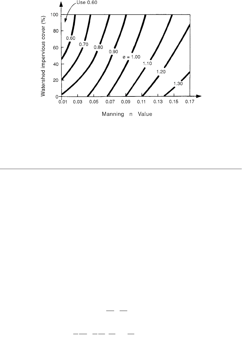
The watershed conveyance factor j is estimated from Fig. 31.12.
SCS Method
The SCS method is based on the time of concentration t
c
(hours) and the watershed area A (square
miles). The duration of the unit hydrograph DD (hours) is given by Eq. (31.48), the time to peak t
p
(hours) and the peak discharge q
p
(cfs) of the unit hydrograph are given by Eq. (31.49) and Eq. (31.50),
and the base time units by Eq. (31.51).
(31.48)
(31.49)
(31.50)
(31.51)
A triangular unit hydrograph of duration DD can be constructed by using Eqs. (31.49) to (31.51). A
unit hydrograph can also be generated by the dimensionless unit hydrograph given in SCS (1972).
TAUPT
pER
=+
()
-
-
0 775 1
0 323
1 285
0 195 0 634
.
.
.
..
ut
k
e
tk
()
=
-
1
tLSI
p
=
-
31 157
023 025 018
. .
...
j
UAT
pp
=¥
-
31 62 10
3096 107
.
..
tAQ
bp
=¥
-
125 89 10
3095
.
.
WAQ
p50
3093 092
16 22 10=¥
-
.
..
WAQ
p75
3079 078
324 10=¥
-
.
..
DD. t
c
= 0 133
t.t
pc
= 067
q
A
t
p
p
=
484
tt
bp
= 267..
© 2003 by CRC Press LLC
31-20 The Civil Engineering Handbook, Second Edition
31.6 Flood Routing Through Channels and Reservoirs
As runoff from land enters into channels, the volume of water temporarily stored in the channel increases.
After the end of precipitation water moves down the channel and the discharge decreases. At a cross
section of a channel, this increase in stage and its decrease at the end of a storm is analogous to the
passage of a wave and hence these are called flood waves.
Whether a flood wave moves down a channel or through a reservoir, water is temporarily stored in
the channel or in the reservoir and is naturally drained out or released. Flood routing is the name given
to a set of techniques that are developed to analyze the passage of a flood wave through the system.
Hydraulic routing is flood routing in which equations which govern the motion of a flood wave — the
St. Venant’s equations — are used. In hydrologic routing, one dimensional, lumped, continuity equation
is solved to estimate the passage of a flood wave. Reservoir routing is similar to hydrologic routing of
flood waves.
Hydraulic Routing
The St. Venant equations that are the basic equations of motion describing the passage of a flood wave
down a channel are in Eq. (31.52) and Eq. (31.53), where Eq. (31.52) is the continuity equation and
Eq. (31.51) the momentum equation.
(31.52)
(31.53)
In Eq. (31.52) and Eq. (31.53), Q is the discharge, A the cross-sectional area of flow, t is the time, x
is the distance along the channel, y is the depth, g is the acceleration due to gravity, s
o
and s
f
are the slopes
FIGURE 31.12 Watershed conveyance factor j. (From Espey, W.H., Jr., Altman, D.G. and Graves, C.B., [1977]
“Nomographs for Ten-Minute Unit Hydrographs for Small Urban Watersheds,” Tech. Memo 32, Urban Water
Resources, Res. Prog., ASCE, New York, NY. With permission.)
∂
∂
+
∂
∂
=
Q
x
A
t
0
11
0
2
A
Q
tAx
Q
A
g
y
x
gs s
of
∂
∂
+
∂
∂
Ê
Ë
Á
ˆ
¯
˜
+
∂
∂
--
()
=
© 2003 by CRC Press LLC

Surface Water Hydrology 31-21
of channel bottom and of the energy grade line, respectively. These equations are first order, nonlinear,
hyperbolic partial differential equations. Given a set of boundary and initial conditions, they can be
solved numerically for discharge and depth (Lai, 1986). Another input is the roughness coefficient,
Manning’s n. St. Venant equations are often simplified and solved as approximate solutions are sufficient
in many cases. Two of these simplified solutions are the kinematic wave and diffusion approximations.
Kinematic wave approximation
In this case the momentum equation is reduced to Eq. (31.54) and the continuity equation is retained.
The resulting equations are:
(31.52)
(31.54)
In this approximation, the dynamic terms in the momentum equation are ignored. Consequently, the
discharge and stage variation both in time and space must be small for the kinematic wave approximation
to be valid.
Diffusion Approximation
In this case, in addition to the slope terms, the term involving ∂y/∂x in Eq. (31.53) is retained to give
the system of Eqs. (31.52) and (31.55). When the stage variation with distance is significant the diffusion
wave approximation gives better results than the kinematic wave approximation.
(31.52)
(31.55)
Kinematic wave approximation has been used in urban hydrology and for modeling flows from small
areas. The diffusion wave approximation is used to route floods through streams. Although a few closed
form solutions are available for simple cases of kinematic wave routing, numerical methods are used to
solve even these simpler equations (Singh, 1988). Hydrologic routing is often used because of its simplicity.
Hydrologic Channel Routing
The storage S in a channel reach is a function of both the inflow I and outflow O from a reach. The
continuity equation for this system is given in Eq. (31.56)
(31.56)
The routing problem is, given the inflow and an initial outflow, to estimate the outflow. In the
Muskingum method, the storage function is assumed to be a linear function of inflow and outflow as in
Eq. (31.57).
(31.57)
Writing Eq. (31.57) in a discrete form in terms of storage at times j and j+1 we get Eq. (31.58), where
Dt is the time interval between j and j+1.
∂
∂
+
∂
∂
=
Q
x
A
t
0
ss
of
=
∂
∂
+
∂
∂
=
Q
x
A
t
0
∂
∂
-+=
y
x
ss
of
0
dS
dt
I=-0
SKxI x=+-
()
[]
10
© 2003 by CRC Press LLC