Van Kreveld M., Nievergelt J., Roos T., Widmayer P. (eds.) Algorithmic Foundations of Geographic Information Systems
Подождите немного. Документ загружается.

density
elevation
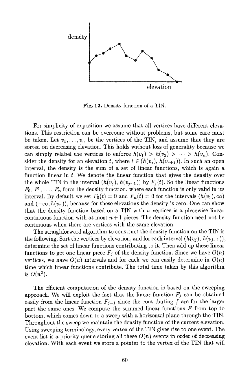
Fig. 12. Density function of a TIN.
For simplicity of exposition we assume that all vertices have different eleva-
tions. This restriction can be overcome without problems, but some care must
be taken. Let vl,..., v~ be the vertices of the TIN, and assume that they are
sorted on decreasing elevation. This holds without loss of generality because we
can simply relabel the vertices to enforce
h(vl) > h(v2) > ... > h(v~).
Con-
sider the density for an elevation
t,
where
t E (h(vj), h(vj+l)).
In such an open
interval, the density is the sum of a set of linear functions, which is again a
function linear in t. We denote the linear function that gives the density over
the whole TIN in the interval
(h(vy), h(vj+l))
by
Fj(t).
So the linear functions
Fo,
FI,..., F~ form the density function, where each function is only valid in its
interval. By default we set
Fo(t)
= 0 and
F,~(t) = 0
for the intervals
(h(vl), ce)
and (-ec, h(v~)), because for these elevations the density is zero. One can show
that the density function based on a TIN with n vertices is a piecewise linear
continuous function with at most n + 1 pieces. The density function need not be
continuous when there are vertices with the same elevation.
The straighforward algorithm to construct the density function on the TIN is
the following. Sort the vertices by elevation, and for each interval (h(vj),
h(vj+l
)),
determine the set of linear functions contributing to it. Then add up these linear
functions to get one linear piece Fj of the density function. Since we have
O(n)
vertices, we have
O(n)
intervals and for each we can easily determine in
O(n)
time which linear functions contribute. The total time taken by this algorithm
is O(n2).
The efficient computation of the density function is based on the sweeping
approach. We will exploit the fact that the linear function Fj can be obtained
easily from the linear function Fj-1 since the contributing f are for the larger
part the same ones. We compute the summed linear functions F from top to
bottom, which comes down to a sweep with a horizontal plane through the TIN.
Throughout the sweep we maintain the density function of the current elevation.
Using sweeping terminology, every vertex of the TIN gives rise to one event. The
event list is a priority queue storing all these
O(n)
events in order of decreasing
elevation. With each event we store a pointer to the vertex of the TIN that will
60
cause the event. The status structure is trivial: it is simply the summed linear
function F for the current position of the sweep plane, and is stored in two reals.
sweep
plane
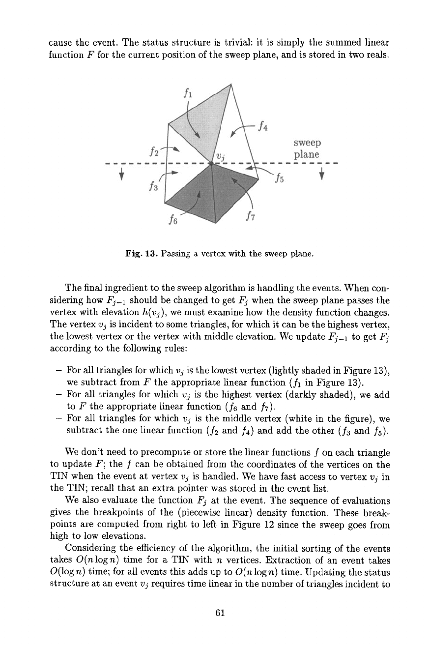
Fig. 13. Passing a vertex with the sweep plane.
The final ingredient to the sweep algorithm is handling the events. When con-
sidering how Fj-1 should be changed to get Fj when the sweep plane passes the
vertex with elevation
h(vj),
we must examine how the density function changes.
The vertex vj is incident to some triangles, for which it can be the highest vertex,
the lowest vertex or the vertex with middle elevation. We update Fj-t to get
Fj
according to the following rules:
- For all triangles for which
vj
is the lowest vertex (lightly shaded in Figure 13),
we subtract from F the appropriate linear function (fl in Figure 13).
- For all triangles for which vj is the highest vertex (darkly shaded), we add
to F the appropriate linear function (f6 and fT).
- For all triangles for which
vj
is the middle vertex (white in the figure), we
subtract the one linear function (f2 and f4) and add the other (f3 and fs)-
We don't need to precompute or store the linear functions f on each triangle
to update F; the f can be obtained from the coordinates of the vertices on the
TIN when the event at vertex vj is handled. We have fast access to vertex
vj
in
the TIN; recall that an extra pointer was stored in the event list.
We also evaluate the function
Fj
at the event. The sequence of evaluations
gives the breakpoints of the (piecewise linear) density function. These break-
points are computed from right to left in Figure 12 since the sweep goes from
high to low elevations.
Considering the efficiency of the algorithm, the initial sorting of the events
takes
O(nlogn)
time for a TIN with n vertices. Extraction of an event takes
O(log n) time; for all events this adds up to
O(n
log n) time. Updating the status
structure at an event vj requires time linear in the number of triangles incident to
61
v3. Summed over all vertices this is linear in n by Euler's formula. The evaluation
to determine the breakpoints requires constant time per event. So in total the
sweep algorithm requires
O(nlogn)
time.
Once the density function is computed, the class intervals may be determined.
Suppose as an example that the objective is to determine seven classes such that
each class occupies an equivalent amount of area on an contour line map. We
assume that the contour line map and the TIN have the same domain, otherwise
we can clip the TIN with the domain of the contour line map before doing the
sweep. The total area of the contour line map is the same as the total area under
the density function and is denoted A. The area under the density function in the
elevation interval
In, b]
is denoted
A(a, b).
If
F(t)
denotes the (piecewise linear)
density function, then
f°
A(a, b) = F(t)dt
The value of A(a, b) is exactly the area for the class [a, b] on the contour line
map. We know the total area A and compute
A/7,
the desired area for each class.
We then determine the lowest elevation such that
A/7
of the area is below that
elevation. This operation is easy by scanning over the known density function
F(t) from left to right and maintaining the area under F(t) (this is also a kind
of sweep). This gives the lowest class boundary. Continuing the scan gives all six
boundaries of the seven classes in
O(n)
time. In a similar way one can compute
a non-fixed number of classes with the property that the within-class variance
is less than or equal to a certain threshold, for each class. Finally, the density
function can be used class interval selection by natural breaks in the data: They
are the local minima of
F(t).
We refer to Burrough [4] and Evans [27] for other
classification schemes.
The sweep algorithm that was described for the density function requires
linear working storage to store all the events. For most realistic terrains, the
working storage can be reduced considerably. We make the following simple
observation. Every vertex except the local maxima--the peaks--have a higher
neighbor in the TIN. So we can initialize the event list with the local maxima
only. When the event at a vertex v is handled, we insert all lower neighbors of
v in the event list. This guarantees that every event is present in the event list
when the sweep plane reaches it The storage required by the algorithm is linear
in the sum of the number of local maxima and the number of edges in the largest
complexity cross-section.
7 Topographic Features
Geomorphologists study the shape of the land, and what processes influence
it [56, 60, 104]. The quantification of the shape of the land is necessary in order
automatically recognize certain features of shape. This on its turn may lead to
a partition of the land into regions where for instance erosional processes have
the same behavior.
62
Terrain features can be zero-, one-, or two-dimensional. We discuss the most
important ones in the next subsections. Then we treat slope and aspect defined
on a terrain.
7.1 Points on Terrains
Any point on a terrain has a certain elevation. When we also consider the neigh-
borhood of a point, the slope and aspect at it can be defined. The slope (also
called gradient) at a point is the maximum ratio of change in elevation and
change of position in the xy-ptane at that point. Mathematically, it is the max-
imum value of the directional derivative at that point (maximized over the di-
rection). Note that the slope of an elevation model is an elevation model itself.
Therefore it can be visualized, for example, as a contour line map by classification
of the slopes.
The aspect or exposure of a point in an elevation model is the compass
direction in which the directional derivative is maximum. With an aspect map
it is easy to see which hill sides face to the south, for instance. The aspect of an
elevation model is not an elevation model. Instead, it is a bivariate function that
maps ~ x ~ to the circular scale (-~, ~]. It is undefined at points that lie on a
horizontal part of the terrain. The combination of slope and aspect is needed to
produce hill shading on maps.
On a terrain there are certain special points that are more important or
characteristic than others. These are the peaks, the pits, and the passes. The
latter are also called saddles. A peak is a point such that in some neighborhood
of it, there is no higher point. Similarly, in some neighborhood of a pit there is no
lower point. A pass is a point where locally, four (or more) different parts of the
contour lines meet. These definitions don't specify what neighborhood should
be taken, and what should be considered a peak when there is a whole region of
equal elevation points. Choices of this type have to be taken depending on the
application.
Peaks, pits, and passes are elements that are used to describe terrain form.
They are the basis of so-called surface networks and their relatives [96, 122, 127].
One such relative, the Warntz network, can be obtained by first identifying all
passes, and from there, traverse the terrain in the directions of steepest ascent
and steepest descent until peaks or pits are reached. The paths traversed together
define a partition of the terrain into regions, of which one can hope that they
have similar geomorphologicat features. What should be considered a pass for
this idea to work well has considerable influence on the output [126].
7.2 Valleys and Ridges
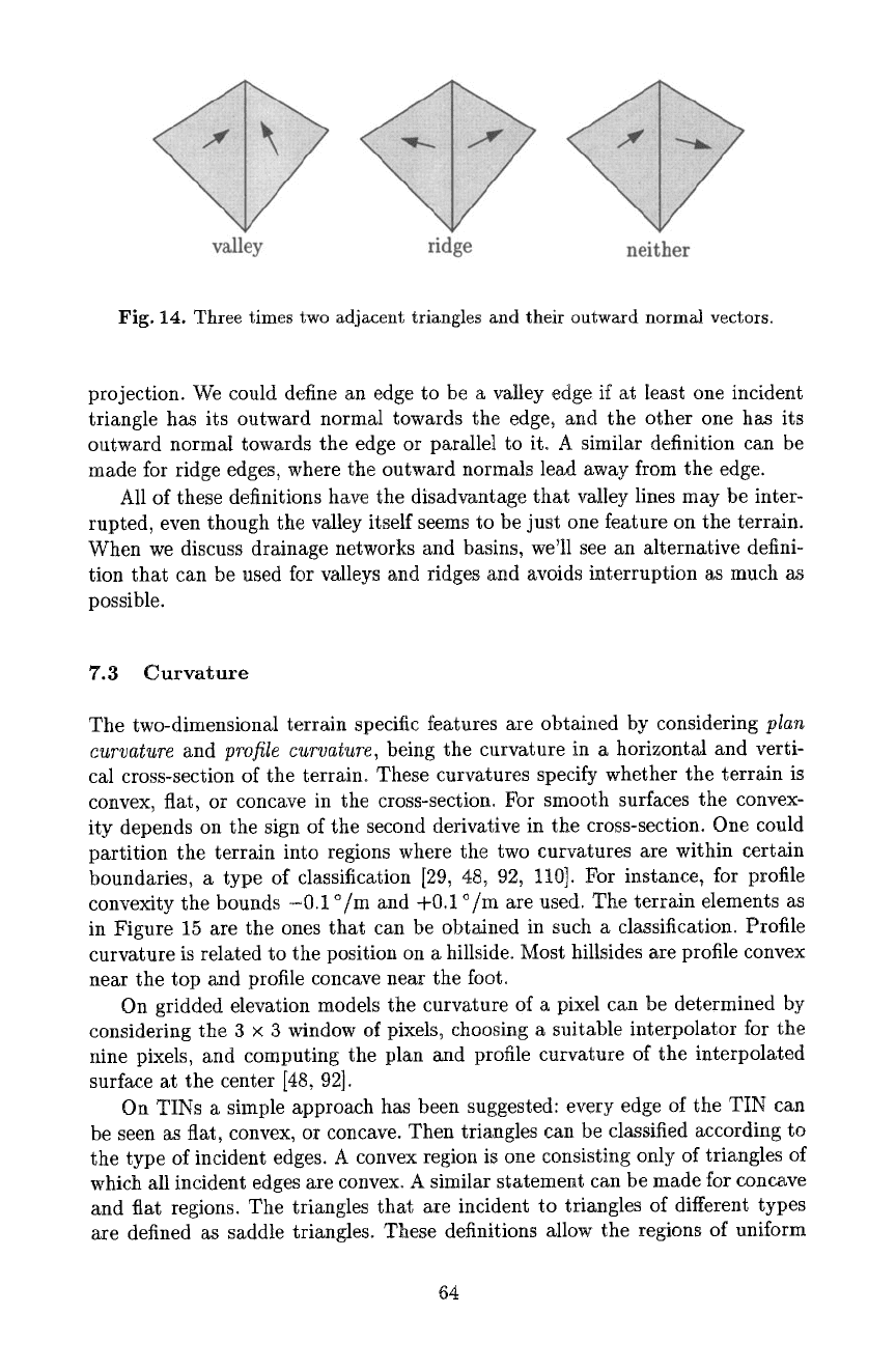
Valleys on a TIN are 1-dimensional features. They are usually defined as the
edges for which the two incident triangles each have an outward normal vector
whose vertical projection on the xy-plane is directed towards the valley edge,
when it is also projected vertically [42, 114]. There are potential problems with
this definition if the outward normal vectors are parallel to the edge, in the
63
valley ridge neither
Fig. 14. Three times two adjacent triangles and their outward normal vectors.
projection. We could define an edge to be a valley edge if at least one incident
triangle has its outward normal towards the edge, and the other one has its
outward normal towards the edge or parallel to it o A similar definition can be
made for ridge edges, where the outward normals lead away from the edge.
All of these definitions have the disadvantage that valley lines may be inter-
rupted, even though the valley itself seems to be just one feature on the terrain.
When we discuss drainage networks and basins, we'll see an alternative defini-
tion that can be used for valleys and ridges and avoids interruption as much as
possible.
7.3 Curvature
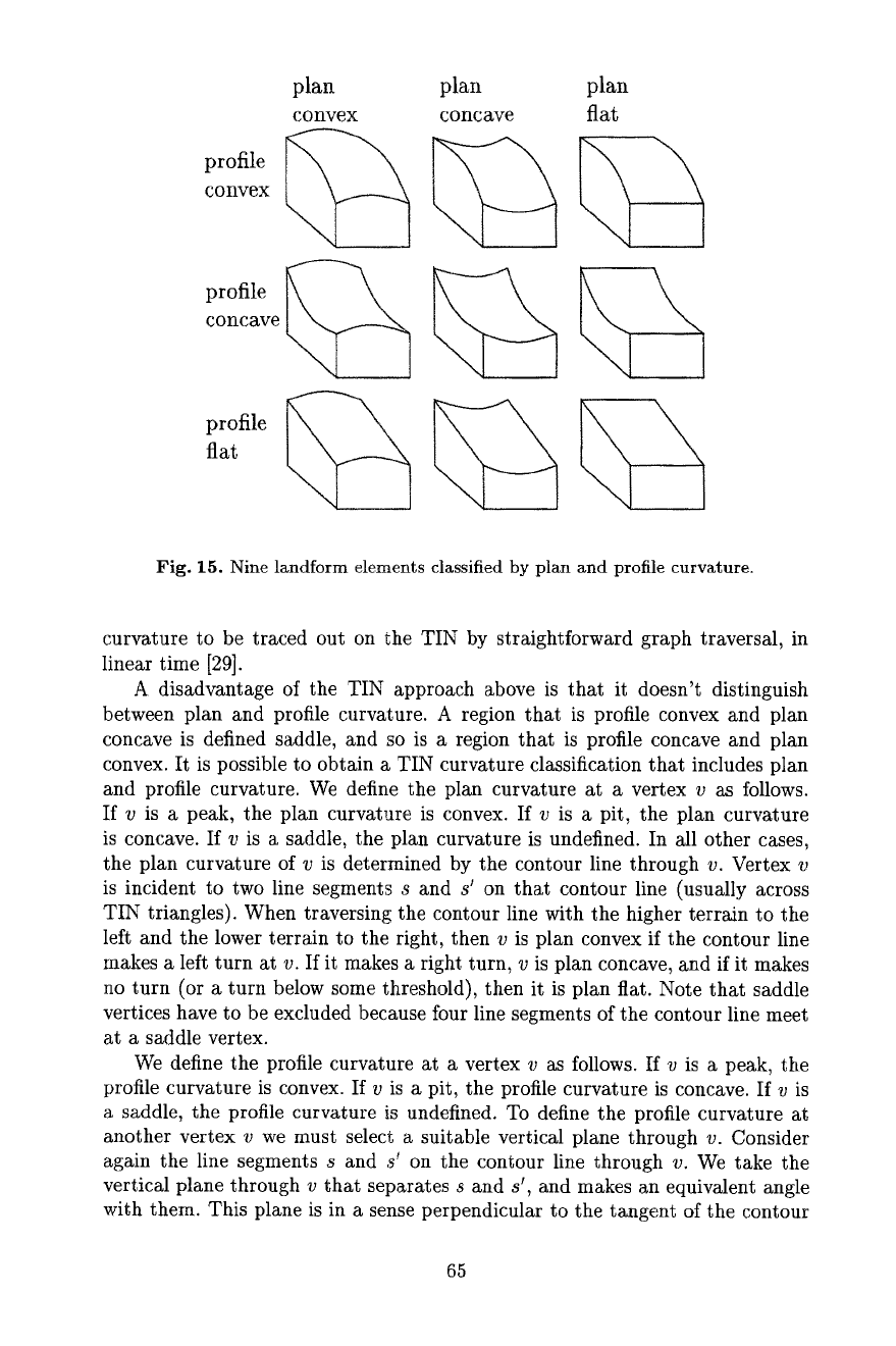
The two-dimensional terrain specific features are obtained by considering
plan
curvature
and
profile curvature,
being the curvature in a horizontal and verti-
cal cross-section of the terrain° These curvatures specify whether the terrain is
convex, flat, or concave in the cross-section. For smooth surfaces the convex-
ity depends on the sign of the second derivative in the cross-section. One could
partition the terrain into regions where the two curvatures are within certain
boundaries, a type of classification [29, 48, 92, 110]. For instance, for profile
convexity the bounds -0.1 °/m and +0.1 °/m are used. The terrain elements as
in Figure 15 are the ones that can be obtained in such a classification. Profile
curvature is related to the position on a hillside. Most hillsides are profile convex
near the top and profile concave near the foot.
On gridded elevation models the curvature of a pixel can be determined by
considering the 3 × 3 window of pixels, choosing a suitable interpolator for the
nine pixels, and computing the plan and profile curvature of the interpolated
surface at the center [48, 92].
On TINs a simple approach has been suggested: every edge of the TIN can
be seen as fiat, convex, or concave. Then triangles can be classified according to
the type of incident edges. A convex region is one consisting only of triangles of
which all incident edges are convex. A similar statement can be made for concave
and flat regions. The triangles that are incident to triangles of different types
are defined as saddle triangles. These definitions allow the regions of uniform
64
plan plan plan
convex concave fiat
profile
convex
profile ~
concave ~
profile ~'~
Fig. 15. Nine landform elements classified by plan and profile curvature.
curvature to be traced out on the TIN by straightforward graph traversal, in
linear time [29].
A disadvantage of the TIN approach above is that it doesn't distinguish
between plan and profile curvature. A region that is profile convex and plan
concave is defined saddle, and so is a region that is profile concave and plan
convex. It is possible to obtain a TIN curvature classification that includes plan
and profile curvature. We define the plan curvature at a vertex v as follows.
If v is a peak, the plan curvature is convex. If v is a pit, the plan curvature
is concave. If v is a saddle, the plan curvature is undefined. In all other cases,
the plan curvature of v is determined by the contour line through v. Vertex v
is incident to two line segments s and g on that contour line (usually across
TIN triangles). When traversing the contour line with the higher terrain to the
left and the lower terrain to the right, then v is plan convex if the contour line
makes a left turn at v. If it makes a right turn, v is plan concave, and if it makes
no turn (or a turn below some threshold), then it is plan flat. Note that saddle
vertices have to be excluded because four line segments of the contour line meet
at a saddle vertex.
We define the profile curvature at a vertex v as follows. If v is a peak, the
profile curvature is convex. If v is a pit, the profile curvature is concave. If v is
a saddle, the profile curvature is undefined. To define the profile curvature at
another vertex v we must select a suitable verticM plane through v. Consider
agMn the line segments s and s ~ on the contour line through v. We take the
vertical plane through v that separates s and s', and makes an equivalent angle
with them. This plane is in a sense perpendicular to the tangent of the contour
65
line at v, and therefore a reasonable choice. Next we consider the intersection
of the vertical plane with the terrain at v, which is the profile. We can define
concexity, concavity, and flatness in the profile in the obvious way.
V,C • V~V ~,V
OV,V OC~V
•
V,V
•
Oc,f C,C
oV~C
vy
C,V
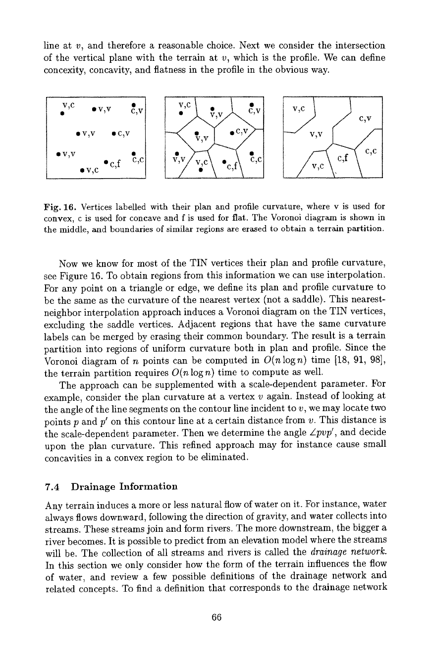
Fig. 16. Vertices labelled with their plan and profile curvature, where v is used for
convex, c is used for concave and f is used for flat. The Voronoi diagram is shown in
the middle, and boundaries of similar regions are erased to obtain a terrain partition.
Now we know for most of the TIN vertices their plan and profile curvature,
see Figure 16. To obtain regions from this information we can use interpolation.
For any point on a triangle or edge, we define its plan and profile curvature to
be the same as the curvature of the nearest vertex (not a saddle). This nearest-
neighbor interpolation approach induces a Voronoi diagram on the TIN vertices,
excluding the saddle vertices. Adjacent regions that have the same curvature
labels can be merged by erasing their common boundary. The result is a terrain
partition into regions of uniform curvature both in plan and profile. Since the
Voronoi diagram of n points can be computed in
O(nlogn)
time [18, 91, 98],
the terrain partition requires
O(n
log n) time to compute as well.
The approach can be supplemented with a scale-dependent parameter. For
example, consider the plan curvature at a vertex v again. Instead of looking at
the angle of the line segments on the contour line incident to v, we may locate two
points p and p' on this contour line at a certain distance from v. This distance is
the scale-dependent parameter. Then we determine the angle
Zpvp',
and decide
upon the plan curvature. This refined approach may for instance cause small
concavities in a convex region to be eliminated.
7.4 Drainage Information
Any terrain induces a more or less natural flow of water on it. For instance, water
always flows downward, following the direction of gravity, and water collects into
streams. These streams join and form rivers. The more downstream, the bigger a
river becomes. It is possible to predict from an elevation model where the streams
will be. The collection of all streams and rivers is called the
drainage network.
In this section we only consider how the form of the terrain influences the flow
of water, and review a few possible definitions of the drainage network and
related concepts. To find a definition that corresponds to the drainage network
66
in reality is a problem that requires various types of data of the terrain. The
area of hydrology Mso includes issues like surface permeability, subsurface flow,
evaporation, and more [80, 85].
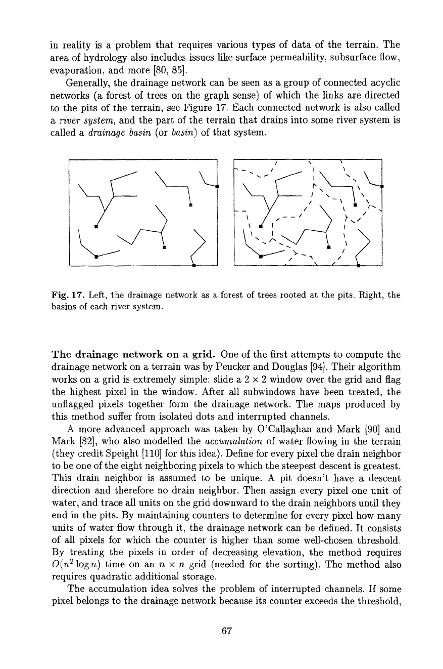
Generally, the drainage network can be seen as a group of connected acyclic
networks (a forest of trees on the graph sense) of which the links are directed
to the pits of the terrain, see Figure 17. Each connected network is also called
a river system,
and the part of the terrain that drains into some river system is
called a
drainage basin
(or
basin)
of that system.
\,
-_ V + \ ~ +~,
, / .__,, x ~.,,.;
\-'--'>/
, 2
Fig. 17. Left, the drainage network as a forest of trees rooted at the pits. Right, the
basins of each river system.
The drainage network on a grid. One of the first attempts to compute the
drainage network on a terrain was by Peucker and Douglas [94]. Their algorithm
works on a grid is extremely simple: slide a 2 × 2 window over the grid and flag
the highest pixel in the window. After all subwindows have been treated, the
unflagged pixels together form the drainage network. The maps produced by
this method suffer from isolated dots and interrupted channels.
A more advanced approach was taken by O'Callagha~ and Mark [90] and
Mark [82], who also modelled the
accumulation
of water flowing in the terrain
(they credit Speight [110] for this idea). Define for every pixel the drain neighbor
to be one of the eight neighboring pixels to which the steepest descent is greatest.
This drain neighbor is assumed to be unique. A pit doesn't have a descent
direction and therefore no drain neighbor. Then assign every pixel one unit of
water, and trace all units on the grid downward to the drain neighbors until they
end in the pits. By maintaining counters to determine for every pixel how many
units of water flow through it, the drainage network can be defined. It consists
of all pixels for which the counter is higher than some well-chosen threshold.
By treating the pixels in order of decreasing elevation, the method requires
O(n ~
logn) time on an n × n grid (needed for the sorting). The method also
requires quadratic additionM storage.
The accumulation idea solves the problem of interrupted channels. If some
pixel belongs to the drainage network because its counter exceeds the threshold,
67
then the whole path along drain neighbors to a pit must also be part of the
drainage network. The accumulation idea also helps to define drainage basins.
Since the path from any pixel can be traced to a pit, it is possible to determine
what pixels drain into any pit. So it is possible to outline the basins, the parts
of the terrain drain into one single pit.
The drainage network on a TIN. On TINs, a definition of the drainage net-
work has been suggested by Frank et al. [42]. They define the drainage network
to consist of all valley edges of the TIN. This definition suffers from the possible
interruption of streams, which can end in points other than pits, as observed by
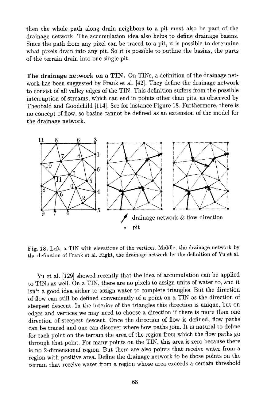
Theobald and Goodchild [114]. See for instance Figure 18. Furthermore, there is
no concept of flow, so basins cannot be defined as an extension of the model for
the drainage network.
11 8 6 3
1
7. ~,6
9 7 6
I
drainage network g~ flow direction
pit
Fig. 18. Left, a TIN with elevations of the vertices. Middle, the drainage network by
the definition of Frank et al. Right, the drainage network by the definition of Yu et al.
Yu et al. [129] showed recently that the idea of accumulation can be applied
to TINs as well. On a TIN, there are no pixels to assign units of water to, and it
isn't a good idea either to assign water to complete triangles. But the direction
of flow can still be defined conveniently of a point on a TIN as the direction of
steepest descent. In the interior of the triangles this direction is unique, but on
edges and vertices we may need to choose a direction if there is more than one
direction of steepest descent. Once the direction of flow is defined~ flow paths
can be traced and one can discover where fiow paths join. It is natural to define
for each point on the terrain the area of the region from which the flow paths go
through that point. For many points on the TIN, this area is zero because there
is no 2-dimensional region. But there are Mso points that receive water from a
region with positive area. Define the drainage network to be those points on the
terrain that receive water from a region whose area exceeds a certain threshold
68
area. We'll study the case where the threshold is set to 0. it is clear that the
dralnge network we obtain will include all drainage networks for larger threshold
values.
One can show a number of properties of the drainage network defined this
way. Most importantly, the drainage network consists of all valley edges, and
furthermore, exactly of all flow paths from their lower vertices. This follows from
the fact that water can only start accumulating at valley edges. The drainage
network will have merge points where two or more streams join and continue
together. These merge points are either vertices of the TIN, or points on valley
edges. Since we assumed that at every point of the TIN the direction of flow is
unique, streams cannot split.
When comparing the definitions of Frank et al. and Yu et al. we can easily
observe that under the former definition, the drainage network has complexity
at most linear in the number of edges of the TIN. It is considerably less obvious
what the size of the drainage network is under the second definition. De Berg
et al. [16] have shown that it is at most cubic in the number of edges of the
TIN, and that the cubic bound is tight for some artificially constructed TINs.
Whether the cubic worst case bound has any relevance in practice is doubtful.
An emperical study on this issue has been done and the actual size on real terrain
data appears to be roughly 20% more than under the definition by Frank et at.
The tests were done on six different terrains represented by TINs with up to
12,000 vertices [115].
To compute the drainage network by the definition of Yu et al., we first
identify all valley edges, and then follow the flow paths of their lower vertices
to the pits. Since flow paths can merge, we can stop tracing any flow path from
a point where another flow path has already gone through. So, whenever a flow
path is traced, it is marked on the terrain itself to make sure that the same
flow path isn't traced again and again. The resulting algorithm requires time
O(n + k),
where k is the complexity of the drainage network.
Drainage basins, catchment areas, generalization~ and spurious pits.
The study of drainage on a terrain using the definition of Yu et at. [129] can
be extended in various ways. Since it incorporates the notion of flow and ac-
cumulation, it becomes possible to determine the basins of the different river
systems, and also the area of the terrain that drains into each river system. For
any point on the terrain, we define the
catchment area
to be the part of the
terrain that drains through that point, eventually. The definition above of the
drainage network includes exactly the points that have a catchment area that
is 2-dimensional, no matter how small the area. As a consequence, many small
streams will be included in the drainage network.
We can also define a
generalized
drainage network by selecting the points of
which the catchment area has at least a certain size. Since it is possible to deter-
mine the size of the catchment area for each point on the terrain--in particular,
on the original drainage network--we can also compute the generalized drainage
network. Other methods to compute the generalized drainage network include
69
