U.S. Geological Survey Open-File Report 2010–1255, 2010. 1 pl.,
27-p. table
Карта полезных ископаемых Евразии (в пределах СССР), En. Векторная. Включает Карту и Таблицу с перечнем и кратким описанием месторождений.
Первоисточник - сайт Геологической службы США http://pubs.usgs.gov/ Abstract
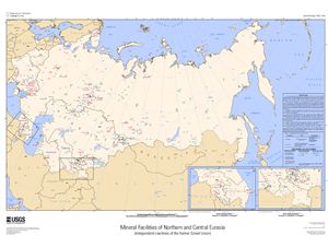
This map displays almost 900 records of mineral facilities within the countries that formerly constituted the Union of Soviet Socialist Republics (USSR). Each record represents one commodity and one facility type at a single geographic location. Facility types include mines, oil and gas fields, and plants, such as refineries, smelters, and mills. Common commodities of interest include aluminum, cement, coal, copper, gold, iron and steel, lead, nickel, petroleum, salt, silver, and zinc. Records include attributes, such as commodity, country, location, company name, facility type and capacity (if applicable), and latitude and longitude geographical coordinates (in both degrees-minutes-seconds and decimal degrees).
The data shown on this map and in table 1 were compiled from multiple sources, including (1) the most recently available data from the U.S. Geological Survey (USGS) Minerals Yearbook (Europe and Central Eurasia volume), (2) mineral statistics and information from the USGS Minerals Information Web site (http://minerals.usgs.gov/), and (3) data collected by the USGS minerals information country specialists from sources, such as statistical publications of individual countries, annual reports and press releases of operating companies, and trade jouals. Data reflect the most recent published table of industry structure for each country at the time of this publication. Additional information is available from the country specialists listed in table 2.
Карта полезных ископаемых Евразии (в пределах СССР), En. Векторная. Включает Карту и Таблицу с перечнем и кратким описанием месторождений.
Первоисточник - сайт Геологической службы США http://pubs.usgs.gov/ Abstract
This map displays almost 900 records of mineral facilities within the countries that formerly constituted the Union of Soviet Socialist Republics (USSR). Each record represents one commodity and one facility type at a single geographic location. Facility types include mines, oil and gas fields, and plants, such as refineries, smelters, and mills. Common commodities of interest include aluminum, cement, coal, copper, gold, iron and steel, lead, nickel, petroleum, salt, silver, and zinc. Records include attributes, such as commodity, country, location, company name, facility type and capacity (if applicable), and latitude and longitude geographical coordinates (in both degrees-minutes-seconds and decimal degrees).
The data shown on this map and in table 1 were compiled from multiple sources, including (1) the most recently available data from the U.S. Geological Survey (USGS) Minerals Yearbook (Europe and Central Eurasia volume), (2) mineral statistics and information from the USGS Minerals Information Web site (http://minerals.usgs.gov/), and (3) data collected by the USGS minerals information country specialists from sources, such as statistical publications of individual countries, annual reports and press releases of operating companies, and trade jouals. Data reflect the most recent published table of industry structure for each country at the time of this publication. Additional information is available from the country specialists listed in table 2.