Caers J. Modeling Uncertainty in the Earth Sciences
Подождите немного. Документ загружается.


P1: OTA/XYZ P2: ABC
JWST061-01 JWST061-Caers April 6, 2011 13:15 Printer Name: Yet to Come
1
Introduction
1.1 Example Application
1.1.1 Description
To illustrate the need for modeling uncertainty and the concepts, as well as tools, cov-
ered in this book, we start off with a virtual case study. “Virtual” meaning that the study
concerns an actual situation in an actual area of the world; however, the data, geological
studies and, most importantly, the practical outcomes of this example should not be taken
as “truth,” which is understandably so after reading the application case.
Much of the world’s drinking water is supplied from groundwater sources. Over the
past several decades, many aquifers have been compromised by surface-borne contam-
inants due to urban growth and farming activities. Further contamination will continue
to be a threat until critical surface recharge locations are zoned as groundwater protec-
tion areas. This can only be successfully achieved if the hydraulically complex con-
nections between the contaminant sources at the surface and the underlying aquifers
are understood.
Denmark is one example of this type of scenario. Since 1999, in an effort to identify
crucial recharge zones (zones where water enters the groundwater system to replenish
the system), extensive geophysical data sets were collected over the Danish countryside –
the areas designated as particularly valuable due to their high rate of water extraction. The
data were collected with the intention of making more informed decisions regarding the
designation of recharge protection zones. The magnitude of these decisions is consider-
able, as it could involve the relocation of farms, industry, city development and water-
works together with related large compensations. Consequently, incorrectly identifying
a vulnerable area can lead to a costly error. In fact, the Danish Government set out a
10-point program (Figure 1.1) that sets certain objectives and formulates certain desired
preferences, some of which may be in conflict with keeping the farming industry alive
and ensuring economic health next to ecological health for this area.
The subsurface in Denmark consists of so-called buried valleys, which are considered
the informal term for Pleistocene (Quaternary) subglacial channels. They have also been
Modeling Uncertainty in the Earth Sciences, First Edition. Jef Caers.
© 2011 John Wiley & Sons, Ltd. Published 2011 by John Wiley & Sons, Ltd.
1

P1: OTA/XYZ P2: ABC
JWST061-01 JWST061-Caers April 6, 2011 13:15 Printer Name: Yet to Come
2 CH 1 INTRODUCTION
Danish Government’s 10-point program (1994)
Pesticides dangerous to health and environment shall be removed from the market
Pesticide tax – the consumption of pesticides shall be halved
Nitrate pollution shall be halved before 2000
Organic farming shall be encouraged
Protection of areas of special interest for drinking water
New Soil Contamination Act – waste deposits shall be cleaned up
Increased afforestation and restoration of nature to protect groundwater
Strengthening of the EU achievements
Increased control of groundwater and drinking water quality
Dialogue with the farmers and their organisations
Source: http://www.geus.dk/program-areas/water/denmark/case_groundwaterprotection_print.pdf
Figure 1.1 Objectives of the Danish Government.
described as the result of waxing and waning of Pleistocene ice sheets. The primary
method by which these valleys are formed is subglacial meltwater erosion under the ice or
in front of the ice margin. Thus, the valley formation is directly related to the morphology
and erodability of the geological strata. The secondary method is through direct glacial
erosion by ice sheets.
Several of the processes that created and filled buried valleys are important for under-
standing the complexity of the Danish aquifer systems and their vulnerability to surface-
borne pollutants. In Denmark, the superposition of three different generations of glacia-
tions has been observed. Thus, multigeneration glacial valleys cross-cut each other and
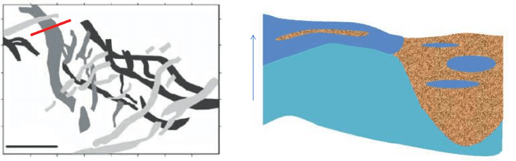
can also appear to abruptly end (as seen in Figure 1.2). The existence and location of
these glacial valleys can be thought of as the primary level of Denmark’s aquifer system
structure. If largely filled with sand, the buried valley has potential for being a high vol-
ume aquifer (reservoir). However, these buried valleys can be “re-used,” as revealed by
the observed cut-and-fill structures. This describes the secondary level of uncertainty of
heterogeneity in Danish aquifer systems.
Most cut-and-fill structures are narrower than the overall buried valley, but in some places
very wide structures that span the entire valley width can be seen. The complex internal
structure can be observed in seismic surveys, electromagnetic surveys and occasionally in
borehole data.
—Sandersen and Jorgensen (2006)
Figure 1.2 shows a few different possible internal heterogeneities and varying extent
of overlying strata, which deems the valley as actually “buried.”
Due to the generally complex internal structure of the valleys, potentially protective
clay layers above the aquifers are likely to be discontinuous. The aquifers inside the valley
will thus have a varying degree of natural protection. Even if laterally extensive clay
layers are present, the protective effect will only have local importance if the surrounding
P1: OTA/XYZ P2: ABC
JWST061-01 JWST061-Caers April 6, 2011 13:15 Printer Name: Yet to Come
1.1 EXAMPLE APPLICATION 3
Valley
Non-Valley
Clay lens
Moraine clay
z
A
B
A
B
10 km
Figure 1.2 Geological interpretation of subsurface glacial channels cross-cutting each other
(left). Conceptual view of the inner structure of the glacial channels (right).
sediments are sand-dominated. The valleys may therefore create short-circuits between
the aquifers in the valley and the aquifers in the surrounding strata.
1.1.2 3D Modeling
In this case study, the incompleteness of the information about the subsurface strata makes
making specific decisions such as relocating farms difficult. A geologist may be tempted
to study in great detail the process by which these glacial valleys were created and come
up with a (deterministic) description of these systems based on such understanding, pos-
sibly a computer program to simulate the process that created these systems according the
physical understanding of what is understood to occur. However, such description alone
will fall short in addressing the uncertainty issue that has considerable impact on the de-
cisions made. Indeed, even if full insight into the glaciation process exists (a considerable
assumption), then that would not necessarily provide a deterministic rendering of the ex-
act location of these valleys, let alone the detailed spatial distribution of the lithologies
(shale, sand, gravel, clay) inside such valleys. This does not mean that the study of the ge-
ological processes is useless. On the contrary, such study provides additional information
about the possible spatial variation of such channels next to the data gathered (drilling,
geophysical surveys). Therefore, additional tools are needed that allow the building of a
model of the subsurface glaciations as well as quantifying the uncertainty about the spa-
tial distribution of valley/non-valley and the various lithologies within a valley. Such a
model would ideally include the physical understanding as well as reflecting the lack of
knowledge, either through limited data or limited geological understanding.
Data play a crucial role in building models and constraining any model of uncertainty,
whether simple or complex. In the Danish case, two types of data are present: data ob-
tained through drilling and data obtained through a geophysical method termed time-
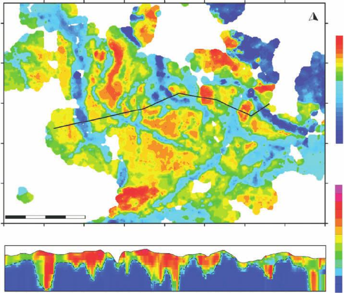
domain electromagnetic surveys (TEM surveys). Figure 1.3 shows the interpretation of
the thickness of the valleys from such surveys, which are basically a collection of 1D
(vertical) soundings. The data collected are typical of many Earth modeling situations:
some detailed small scale information is gathered through sampling (in this case drilling a
well) and some larger scale indirect measurement(s) collected either through geophysical
P1: OTA/XYZ P2: ABC
JWST061-01 JWST061-Caers April 6, 2011 13:15 Printer Name: Yet to Come
4 CH 1 INTRODUCTION
62500006245000624000062350006230000
545000
0
80
40
0
Elevation [m.a.s.l]
–40
–80
2000 4000 6000 8000 10000 12000 14000
Distance [m]
16000 18000 20000 22000 24000 26000 28000
550000 555000 560000 565000 570000 575000
N
Elevation
m.a.s.l.
80
60
40
20
0
–20
–40
–60
–80
–100
–120
–200
Ohm-m
200
160
100
60
40
20
5
A′
A′
A
A
10 km
Figure 1.3 Thickness of the valley complex as processed and interpreted from TEM data. Thicker
strata reflect the existence of valleys (with permission from Elsevier Science).
or remote sensing methodologies. In the Danish study, the TEM data provide a reason-
ably good constraint on the location of the valleys but do not inform the internal valley
structure (small scale variation), while the drilling data provide the exact opposite.
1.2 Modeling Uncertainty
From this case study of modeling the subsurface, several elements in modeling uncer-
tainty that are typical to many similar applications can be identified:
1 Decision making: modeling uncertainty is not a goal on its own, it is usually needed
because a particular decision question is raised. In fact, this decision question is usually
framed in a larger context, such as done by the 10-point program, specifying objectives
and preferences. Two example decisions are in this case: (1) in which areas do we relo-
cate pollution sources and (2) do we consider taking more geophysical data to narrow
the uncertainty on locating vulnerable areas, hence increasing the probability of a good
decision? This latter question is termed a “Value of Information” question. Clearly, we
P1: OTA/XYZ P2: ABC
JWST061-01 JWST061-Caers April 6, 2011 13:15 Printer Name: Yet to Come
1.2 MODELING UNCERTAINTY 5
need to make decisions without perfect information. These narrower decision questions
should not be considered as independent of the larger objective outlined in Figure 1.1.
2 Importance of the geological setting: a critical parameter influencing the decision
is the heterogeneity of the subsurface medium (fluids and soils/rocks). Rarely do we
have perfect information to deterministically model the geological variability of the
subsurface. Hence there is a need to model all aspects of uncertainty as related to the
subsurface heterogeneity. While Figures 1.2 and 1.3 may provide one such interpreta-
tion of the system, often many alternative and competing interpretations are formed.
3 Data: several sources of data are available to constrain the models of uncertainty built.
These data sources can be very diverse, from wells (driller’s logs, well-log, cores, etc.)
to geophysical (TEM data in the Danish case) or remote sensing measurements. Tying
all this data into a single model of uncertainty without making too many assumptions
about the relationships between various data sources is challenging.
From this case study, it is clear that some of the tools for modeling random phenomena
through traditional probability models are too rigid to handle all these complexities. The
nature of modeling uncertainty in the Earth Science has various challenge and issues that
need to be addressed.
1 Modeling uncertainty is often application tailored. If the application changes then the
type of modeling and the approach to modeling uncertainty will be different, hence the
model of uncertainty will be different. Building a model of uncertainty that includes
all possible aspects of what is uncertain is too difficult and often not needed in the first
place. Modeling uncertainty for the sake of uncertainty is basically irrelevant as well
as an impossible task. For example, if one is looking to quantify the global reserves of
an oil reservoir, then the focus should be on the structural model and global parame-
ters such as net-to-gross, while if the question is about drilling the next well, than the
analysis should focus on local reservoir heterogeneity and connectivity of flow units.
2 Several sources of uncertainty exist for this case study:
a Uncertainty related to the measurement errors and processing of the raw measure-
ments.
b Uncertainty related to the fact that processed data can be interpreted in many ways
and, in fact, that data interpretation and processing require a model on their own.
c Uncertainty related to the type of geological setting used, which is interpreted from
data or based on physical models which themselves are uncertain.
d Spatial uncertainty: even if data were perfectly measured, they are still sparse with
respect to the resolution at which we want to build models. This means that various
models with different spatial distributions of properties or layering structures can be
generated matching equally well the same data.
P1: OTA/XYZ P2: ABC
JWST061-01 JWST061-Caers April 6, 2011 13:15 Printer Name: Yet to Come
6 CH 1 INTRODUCTION
e Response uncertainty: this includes uncertainty related to how geological uncertainty
translates into modeling of processes such as flow, transport, wave, heat equations
or even decisions made based on such models. There may be uncertainty related
to the physics of these processes or other parameters that need to be specified to
specify these processes. For example, solving partial differential equations requires
boundary and initial conditions that may be uncertain.
3 Uncertainty assessment is subjective: while a “true” Earth exists with all of its true, but
unknown properties, there is no “true uncertainty.” The existence of a true uncertainty
would call for knowing the truth, which would erase the need for uncertainty assess-
ment. Uncertainty can never be objectively measured. Any assessment of uncertainty
will need to be based on a model. Any model, whether statistically or physically
defined, based on probability theory or fuzzy logic, requires implicit or explicit model
assumptions (because of lack of knowledge or data), hence is necessarily subjective.
There is no true uncertainty; there are only models of uncertainty, hence the title of
this book.
4 High dimensional/spatial aspect: we are dealing with complex Earth systems that re-
quire a large amount of variables to describe them. Typically, we will work with grid-
ded models to represent all aspects of the natural system. If each grid cell in a model
contains a few variables, then easily we have millions of variables for even relatively
small models. Standard approaches of probability become difficult to apply, since prob-
ability theory and statistical techniques common to most introductory text books has
not been developed with these complex situations in mind. Often, it is necessary to per-
form some sensitivity analysis to determine which factors impact our decision most.
Traditional statistical methods for sensitivity analysis are difficult to apply in this high
dimensional and spatial context.
5 Several data sources informing various scales of variability: we will need to deal with
a variety of data or information to constrain models of uncertainty. Without any data,
there would be no modeling. Such data can be detailed information obtained from wells
or more indirect information obtained from geophysical or remote sensing surveys.
Each data source (such as wells) informs what we are modeling at a certain “volume
support” (such as the size of a soil sample) and measures what we are targeting directly
or indirectly, for example, electromagnetic (EM) waves for measuring water saturation.
Following this introductory chapter, this book covers many of these issues in the fol-
lowing chapters:
Chapter 2 Probability, Statistics and Exploratory Data Analysis: basically an
overview of basic statistics and probability theory that is required to understand the
material in subsequent chapters. The aim is not to provide a thorough review of
these fields, but to provide a summary of what is relevant to the kind of modeling in
this book.
P1: OTA/XYZ P2: ABC
JWST061-01 JWST061-Caers April 6, 2011 13:15 Printer Name: Yet to Come
1.2 MODELING UNCERTAINTY 7
Chapter 3 Modeling Uncertainty: Concepts and Philosophies: uncertainty is a
misunderstood concept in many areas of science, so the various pitfalls in assessing
uncertainty are discussed; also, a more conceptual discussion on how to think about
uncertainty is provided. Uncertainty is not a mere mathematical concept, it deals with
our state of knowledge, or lack thereof, as the world can be perceived by human beings.
Therefore, it also has some interesting links with philosophy.
Chapter 4 Engineering the Earth, Making Decisions Under Uncertainty: the basic
ideas of decision analysis are covered without going too much into detail. The lan-
guage of decision analysis is introduced, structuring decision problems is discussed
and some basic tools such as decision trees are introduced. The concept of sensitiv-
ity analysis is introduced; this will play an important role through many chapters in
the book.
Chapter 5 Modeling Spatial Continuity: the chapter covers the various techniques
for modeling spatial variability, whether dealing with modeling a rock type in the sub-
surface, the porosity of these rocks, soil types, clay content, thickness variations and
so on. The models most used in practice for capturing spatial continuity are covered;
these models are (i) the variogram/covariance model, (ii) the Boolean or object model
and (iii) the 3D training image model.
Chapter 6 Modeling Spatial Uncertainty: once a model of spatial continuity is es-
tablished, we can “simulate the Earth” in 2D, 3D or 4D (including time, for exam-
ple) based on that continuity model. The goal of such a simulation exercise, termed
stochastic simulation, is to create multiple Earth representations, termed Earth mod-
els, that reflect the spatial continuity modeled. This set of Earth models is the most
common representation of a “model of uncertainty” used in this book. In accordance
with Chapter 5, three families of techniques are discussed: a variogram based, object
based and 3D training image based.
Chapter 7 Constraining Spatial Uncertainty with Data: this chapter is an extension
of the previous chapter and discusses ways for constraining the various Earth repre-
sentations or models with data. Two types of data are discussed: hard data and soft
data. Hard data are (almost) direct measurements of what we are modeling, while soft
data are everything else. Typically, hard data are samples taken from the Earth, while
typical soft data are geophysical measurements. Two ways of including soft data are
discussed: through a probabilistic approach or through an inverse modeling approach.
Chapter 8 Modeling Structural Uncertainty: the Earth also consists of discrete pla-
nar structures such as a topography, faults and layers. To model these we often use a
modeling approach tailored specifically for such structures that is not easily captured
with a variogram, object or 3D training image approach. In this chapter the basic mod-
eling approach to defining individual faults and layers and methods of combining them
into a consistent structural model are discussed. Since structures are often interpreted
P1: OTA/XYZ P2: ABC
JWST061-01 JWST061-Caers April 6, 2011 13:15 Printer Name: Yet to Come
8 CH 1 INTRODUCTION
from geophysical data, the various sources of uncertainty for structural models and
how they can be consistently constructed are discussed.
Chapter 9 Visualizing Uncertainty: because of the large uncertainty in Earth model-
ing and the many sources of uncertainty present, as well as the large amount of possible
alternative Earth models that can be created, there is a need to get better insight into
the integrated model of uncertainty through graphical representation. Some recently
developed techniques based on distances to represent complex models uncertainty in
simple 2D plots are discussed.
Chapter 10 Modeling Response Uncertainty: modeling uncertainty of the Earth by
itself has little relevance in terms of the practical decision it is necessary to make.
Instead, these models are used to evaluate certain scenarios or, in general, certain re-
sponse functions, such as the total amount of contaminant, the best location for the
sampling, the total amount of carbon dioxide that can be injected without risk, the
best place to store nuclear waste and so on. This calls often for evaluating Earth mod-
els through CPU-expensive transfer functions, such as flow simulators, optimization
codes, climate models and so on, that can take hours or days to run. A few techniques
are presented for assessing response uncertainty that can deal, through model selec-
tion, with the issue of CPU cost in mind.
Chapter 11 Value of Information: before taking any data, such as costly drilling, sam-
pling surveys or geophysical and remote sensing data, it can be quite useful to assess
the value of taking such data. Such value will necessarily depend on the given model
of uncertainty. Often, the more uncertain one is prior to taking any data, the more valu-
able the data may be. In this chapter, techniques are discussed for assessing such value
of information in a formal decision analysis framework with a spatial context in mind.
Chapter 12 Case Study: the book concludes with a case study in value of information
regarding a groundwater contamination problem. The aim of this case study is to il-
lustrate how the various elements in this book come together: decision analysis, 3D
modeling, physical modeling and sensitivity analysis.
Further Reading
BurVal Working Group (2006) Groundwater Resources in Buried Valleys: A Challenge for Geosciences.
Leibniz Institute for Applied Geosciences (GGA-Institut), Hannover, Germany.
Jørgensen, F. and Sandersen, P.B.E. (2006) Buried and open tunnel valleys in Denmark – erosion beneath
multiple ice sheets. Quaternary Science Reviews, 25 (2006) 1339–1363.
Huuse, M., Lykke-Andersen, H. and Piotrowski, J.A. (eds) (2003) Special Issue on Geophysical Investi-
gations of Buried Quaternary Valleys in the Formerly Glaciated NW European Lowland: Significance
for Groundwater Exploration. Journal of Applied Geophysics, 53(4), 153–300.

P1: OTA/XYZ P2: ABC
JWST061-02 JWST061-Caers March 30, 2011 18:55 Printer Name: Yet to Come
2
Review on Statistical Analysis
and Probability Theory
2.1 Introduction
This chapter should be considered mostly as a review of what has been covered in a
basic course in statistics and/or probability theory for engineers or the sciences. It pro-
vides a review with an emphasis of what is important for modeling uncertainty in the
Earth Sciences.
Statistics is a term often used to describe a “collection or summary of a set of numbers.”
Particular examples are labor or baseball statistics, which represent a series of numbers
collected through investigation, sampling, or surveys. These numbers are often recom-
bined or rearranged into a new set of clearly interpretable figures. Such summaries are
needed to reduce the possibly large amount of data, make sense of the data, and derive
conclusions or decisions thereupon. The scientific field of statistics is not very differ-
ent. What statistics provides, however, is a rigorous mathematical framework in which
to analyze sample data and to make conclusions on that basis. However, statistics as a
traditional science has considerable limitations when applied to the Earth sciences. Key
to modeling in the Earth Sciences is the spatial aspect or nature of the data. A sample or
measurement is often attached to a spatial coordinate (x,y,z) describing where the sample
was taken. Traditional statistics very often neglects this spatial context and simply works
with the data as they are. However, from experience, it is known that samples located
close together are more “related” to each other, and this relationship may be useful to
us when interpreting our data. Geostatistics and also spatial statistics are fields that deal
explicitly with data distributed in space or time and aim at explicitly modeling the spatial
relationship between data.
Critical to any statistical study is to obtain a good overview of the data and to obtain
an idea about its key characteristics. This analysis of the data is also termed exploratory
data analysis (EDA). We will distinguish between graphical and numerical techniques.
Modeling Uncertainty in the Earth Sciences, First Edition. Jef Caers.
© 2011 John Wiley & Sons, Ltd. Published 2011 by John Wiley & Sons, Ltd.
9
P1: OTA/XYZ P2: ABC
JWST061-02 JWST061-Caers March 30, 2011 18:55 Printer Name: Yet to Come
10 CH 2 REVIEW ON STATISTICAL ANALYSIS AND PROBABILITY THEORY
2.2 Displaying Data with Graphs
In general, we consider two types of variables:
1 Categorical/Discrete Variables: gender, race, diamond quality category.
2 Continuous Variables: size, value, income, grade.
Some variables are naturally categorical, such as race, while other variables can be both
categorical and continuous depending upon one’s decision. For example, the quality of
diamonds can be fair, good, excellent, or you can model it with the value of the diamond,
which is a continuous variable expressed in US dollars (US$).
Both categorical and continuous variables exhibit a distribution. A distribution tells us
how frequently a variable takes a given value. For categorical cases, this is straightfor-
ward. For each category, one records how many times that object falls in a particular cat-
egory. For continuous variables, this is less obvious, and we will see methods to quantify
frequencies for such variables. Note that continuous variables can always be categorized,
but categorical variables cannot be made uniquely continuous.
2.2.1 Histograms
One of the most common methods for presenting data is the histogram. The histogram
is a visual frequency table that presents how observed values fall within certain intervals
(Figure 2.1). In a histogram, the continuous sample values are divided into intervals of
usually equal width (bins). The width of these bins (i.e. the number of bins into which the
range of values is divided) will determine how the histogram looks (Figure 2.2):
r
Small bins – A lot of detail is observed but those details might be artifacts due to
small sample fluctuations. One may lose the global overview of the message that the
histogram brings, as it becomes too “noisy.”
r
Large bins – One might lose details and important features that are contained in the data.
Histograms are very useful for displaying data, because they are easy to under-
stand and can be easily interpreted by those who are not specialized in statistics. How-
ever, later we will discuss more specialized techniques that allow better visualization of
the data.
In terms of order of importance, one should look at the following when interpreting a
histogram:
1 The overall shape: Shape can be symmetric or skewed. If skewed, it can be skewed to
the left or to the right. Symmetric – left and right sides are almost, but not necessarily,