Daunton M. The Cambridge Urban History of Britain, Volume 3: 1840-1950
Подождите немного. Документ загружается.


for industrialists to serve on town and city councils. Unlike many continental
European countries, national politicians did not continue to rely on a local
power base. In France, the prime minister might well serve as the mayor of a
town, retaining a foothold in both local and national politics. In Britain, Neville
Chamberlain and Herbert Morrison were exceptional in moving into national
politics after a significant involvement in the government of Birmingham and
London. The growth of larger industrial concerns, with merger waves and
flotations at the end of the First World War and again around , weakened
the identity between industrialists and the local town. The external labour
market and sources of information declined in importance, with the growth of
internal training and career structures, and the development of research and
development within the firm. In all of these ways, a strong case can be made for
an erosion of the urban variable by .
However, Rodger and Reeder claim that the extent of change should not be
exaggerated in the interwar period. Although they accept that an independent
civic culture was being eroded in the northern industrial cities, they believe that
the character of industrial districts survived to the end of the period, and the
decomposition of local capital should not be exaggerated. Much depended on
the local economic base of towns. In Leicester and Nottingham, with relatively
small-scale firms in hosiery and lace, and a prosperous domestic market, the vital-
ity of the urban economy and politics continued throughout the interwar
period. Of course, in areas of deep economic depression, urban authorities with
straitened finances could do little to restructure the local economy. Even so, local
or regional issues should not be overlooked. The so-called ‘rationalisation’ of
industry to reduce excess capacity provided many opportunities for bargaining
between industrialists over the location of cuts, with their devastating conse-
quences for the urban community. These tussles were usually within trade asso-
ciations, acting through a national framework involving the Bank of England or
the central government, with little or no involvement by democratically
accountable town and city councils.
Where urban authorities did have a significant role was in the allocation of
resources for different social policies, with measurable effects on infant or mater-
nal mortality, or educational opportunity. The urban authorities were involved
in slum clearance schemes on a large scale, and were major house builders and
owners; they operated transport services and utilities, schools and libraries.
Indeed, the retreat of the middle class from urban government could be looked
at in a different and more positive way: it gave an opportunity for the working
class to take power, and to use the municipality to develop social services. The
Labour party had an important role in increasing the functions of urban govern-
ment between the wars. As Savage and Miles argue, the Labour party built up
support in the working-class neighbourhoods which had emerged in the late
nineteenth century, developing a ward organisation with female membership,
Martin Daunton
Cambridge Histories Online © Cambridge University Press, 2008

and so compensating for the difficulties experienced by trade unions during the
depression. This ward structure, and female participation, turned attention to the
provision of municipal services, especially for women and children. The retreat
of the urban elite meant that Labour was now the main supporter of an active
municipal culture, against the opposition of ‘ratepayers’ concerned about local
spending. Above all, Herbert Morrison presented a vision of efficient urban ser-
vices in London, providing consumers with high standards of transport, housing
and health services. Labour could present itself as a party of effective urban
government, rather than of trade union self-interest.
157
What urban authorities could not do was generate an efficient urban economy
in the face of massive depression. Declining industrial sectors such as cotton
reduced excess capacity throughout Lancashire, rather than operating at the level
of the town to restructure the local economy. Any positive action was the result
of central government policy, on a modest scale from the s and more pow-
erfully after the Second World War, to relocate industry or service employment
from the prosperous South-East and Midlands. The response was national, an
attempt to rectify the problems of distribution of employment and wealth from
outside rather than within the urban system.
(viii)
Despite the loss of urban autonomy and the mounting challenge to the urban
variable by the end of our period, the chapters in this third volume of the
Cambridge Urban History provide a convincing case that towns and cities matter.
Demographic historians realise that the decline in mortality varied between
areas, and reflected local political decisions; they accept the importance of com-
munities in explaining the fall in birth rates. Historians of welfare – of charity,
public spending and self-help – are increasingly interested in the different ‘mix’
of provision at the local as well as national level, and realise that local resources
remained vitally important throughout the period. The resolution of problems
of collective action to allow investment in the infrastructure, and to regulate ‘free
riders’ and natural monopolies, is central to the political history of the period.
The changing balance between urban diseconomies and economies helps to
explain the economic performance of Britain, and the nature of the business
concern. The ability of towns and cities to create ‘social capital’ – patterns of
sociability and associations – helped to mediate conflicts and create social stabil-
ity and economic efficiency.
These issues, amongst many others, are giving a new interest to urban history
Introduction
157
Savage and Miles, Remaking of the British Working Class, pp. –, –; see also M. Savage, ‘Urban
politics and the rise of the Labour party, –’, in L. Jamieson and H. Corr, eds., State, Private
Life and Political Change (Basingstoke, ), pp. –. On the debate on local autonomy, see
below, pp. ‒, , , ‒, ‒, .
Cambridge Histories Online © Cambridge University Press, 2008

which was to some extent lost in the s and s, when sociologists such as
Philip Abrams cast doubt on the importance of towns as an independent vari-
able. In his view, towns were mere containers for more important explanatory
variables. Historians were warned of the dangers of ‘reification’ of the city,
making it a distinct entity; they were urged to study wider processes. But the
problem was also from within urban history, at least for the Victorian period.
Much attention was paid to the construction of towns, to the operation of the
land market and the explanation of building cycles; much less attention was paid
to the social experience of life in the new suburbs, or the ways in which different
parts of the town fitted together – how space was contested and gendered. The
rise of town planning, usually portrayed as a force for progress, lost its appeal at
a time of mounting criticism of the impact of planners on British towns and
cities. Although urban history did flourish in the s and s in the study
of medieval and early modern towns, it seemed much less exciting and challeng-
ing to modern historians.
This introduction has shown that the urban variable is again important to
modern historians, in a way which connects with the work of historians of
gender, of culture and consumption. Demographic historians are aware of the
importance of specific patterns of investment in public health and the impact on
mortality; and the distinctive patterns of marriage or fertility arising from local
labour markets and cultures. Historians of business realise that the performance
of an individual firm is shaped by the urban economy, and by the accumulation
of reputation and social capital within urban society. Historians of welfare have
abandoned a teleological account of the rise of the welfare state, and are inter-
ested in the particular mixtures of charity, self-help and public provision within
specific localities. And cultural historians, with their concern for subjectivities
and identities, are fascinated by the experience of the city. The built form is
important in terms of its iconography, the use made of the street or parks, or the
experience of travel by bus and tube. Instead of narrow accounts of the politics
of this town council or that Board of Guardians, historians are now aware of the
importance of the urban variable in understanding major issues of collective
action and investment, of dealing with market failure and the problems of exter-
nalities. As R. J. Morris has argued, nineteenth-century cities were ‘a vast labor-
atory which tested the effectiveness of market mechanisms to the limit and then
tested the operation of other ways of producing and delivering goods and
services’.
158
Martin Daunton
158
R. J. Morris, ‘Externalities, the market, power structure and the urban agenda’, UHY, (),
–.
Cambridge Histories Online © Cambridge University Press, 2008

·
·
Circulation
Cambridge Histories Online © Cambridge University Press, 2008
Cambridge Histories Online © Cambridge University Press, 2008

·
·
Urban networks
Nature prepares the site, and man organizes it in such fashion as meets his desires
and wants.
Vidal de la Blache,
I
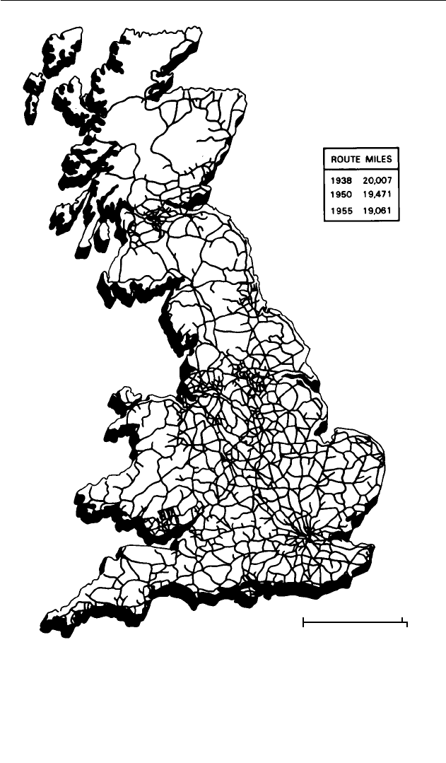
, a spider-web of railways overlay the British landmass from western
Cornwall to the eastern tip of Caithness. Tracks fanned out from London
through cities to the coastal settlements of Wales and Scotland, while branch
lines moved from mills, mines, resorts and ports to the county towns (see Map
.). Commuters rushed from suburbs into London, Glasgow and Manchester,
metropolitan centres surrounded by a dense penumbra of roads and rails.
Threadlines of transport connected a human geography of settlement. In the
eyes of the mapmaker, cities and their interconnections had tamed a world of
mountain and plain, turning natural spaces into corridors, making the remote
accessible. A century earlier, the transport network had a more truncated shape.
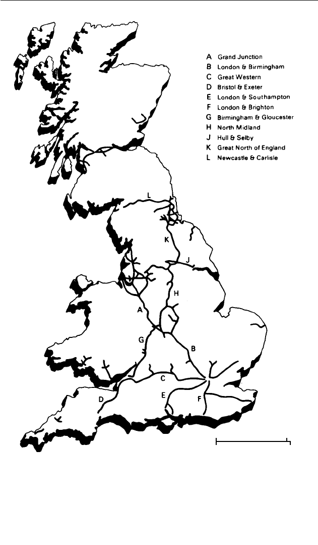
Around , railways linked London only to the largest county towns and the
industrial centres of the North; they had scarcely reached Cornwall, Wales or
the Scottish Highlands (see Map .). A decade later, many new lines connected
East and West, North and South, but large sections of Britain remained unreach-
able by railway (see Map .).
1
Moreover, roads had not yet swollen to accom-
modate automobiles and the needs of suburban residents. Cities, other than
London and a few regional centres, remained small in size. The urban had not
yet dwarfed the rural.
Those who mapped the growing railway network pictured British space as
organised by central cities and transport. Built landscapes dominated natural
ones. Resolutely secular and insular, they privileged the systems of exchange and
control that had arisen in a domestic capitalist economy and a nation-state. The
1
F. Celoria, ‘Telegraphy changed the Victorian scene’, Geographical Magazine (), –.
Cambridge Histories Online © Cambridge University Press, 2008
Lynn Hollen Lees
Map . The railway network c.
Source: Michael Freeman and Derek Aldcroft, Atlas of British Railway History
(London, ), p. .
0 50 miles
0 80 km
Cambridge Histories Online © Cambridge University Press, 2008
Urban networks
Map . The railway network c.
Source: Michael Freeman and Derek Aldcroft, Atlas of British Railway History
(London, ), p. .
0 50 miles
0 80 km
Cambridge Histories Online © Cambridge University Press, 2008
Lynn Hollen Lees
Map . The railway network c.
Source: Michael Freeman and Derek Aldcroft, Atlas of British Railway History
(London, ), p. .
0 50 miles
0 80 km
Cambridge Histories Online © Cambridge University Press, 2008

urban Britain they sketched captures a particular type of organisation, one that
implies stability and centrality, in which size signals complexity and influence
and in which London directed the flows of people, information and capital.
Moreover, they announce closure at the borders, as if water were a barrier rather
than a medium of circulation.
Yet urban networks transcend national borders, reaching out to Ireland and
North America, to Europe and to the rest of the globe. In contrast to closure,
these maps also signal possibility, fluidity; the pathways they depict permitted
multiple systems of circulation which could be adapted, bypassed, extended as
need and inclination dictated. Capitalist economies depend upon the mobility
of capital, labour and information, as well as the ability of capitalists to restruc-
ture modes of production and location. The continuous reshaping of urban
geographies to keep pace with economic restructuring has proved both an urban
boon and a burden. In the words of David Harvey, ‘We look at the material solid-
ity of a building, a canal, a highway, and behind it we see always the insecurity
that lurks within a circulation process of capital, which always asks: how much
more time in this relative space?’
2
These railway maps demarcate a particular period of urban and regional devel-
opment in Britain, the era of high industrialism, which was tied to specific tech-
nologies, investment choices and political arrangements. In slightly over one
hundred years, the urbanism of coal-based manufacturing for export moved
through a cycle of expansion, restructuring and decline, driven by shifts in the
capitalist economy and by changing sources of power. Large-scale industry
moved along with steam engines into an array of British cities, particularly those
near the coalfields in the North and the Midlands. Manufacturing cities, which
captured a major share of capital investment, first reaped the benefits of indus-
trial growth and then paid penalties for overinvestment in obsolescence. As
Britain industrialised and then de-industrialised, substantial changes took place
in the spatial organisation of capitalist relations of production, which were
reflected in the functioning of local geographies of manufacturing, consump-
tion and distribution, as well as in local social relations and hierarchies of power.
Unlike most of Western Europe, Britain’s urban system in the industrial era
included several manufacturing centres in its top ranks. Shifting geographies of
production as well as trade cycles have therefore had an atypically large impact
on major cities in Britain. Along with the decline of shipbuilding, coal mining,
textile production and steel manufacturing has come the relative decline of
Glasgow, Wolverhampton, Bradford and Sheffield. Whereas Manchester was the
‘shock city’ of the s because of its growth, Liverpool and Wigan filled that
function in the s as a result of rampant unemployment. Although the
modern cycle of urban industrial growth and decline extends slightly beyond the
Urban networks
2
D. Harvey, Consciousness and the Urban Experience (Oxford, ), p. .
Cambridge Histories Online © Cambridge University Press, 2008