Environmental Encyclopedia
Подождите немного. Документ загружается.


Environmental Encyclopedia 3
Plastics
Korea, have biological weapons programs. While several
other nations presumably have biological weapons programs,
these nations pose a more significant threat to the United
States and its allies.
[Ken R. Wells]
R
ESOURCES
B
OOKS
Kohn, George C., ed. Encyclopedia of Plague and Pestilence: From Ancient
Times to the Present. New York: Facts on File, Inc., 2001.
P
ERIODICALS
Childress, Diana. “Like Black Smoke, the Black Death’s Journey.” Calliope
(March 2001): 4.
Ligomeka, Brian. “Bubonic Plague Breaks Out in Lilongwe.” Africa News
Service, May 10, 2002.
Mackenzie, Deborah. “All Fall Down: The Black Death Wasn’t Caused
by Bubonic Plague, and We Need to Find the Real Culprit Before it Strikes
Again.” New Scientist (November 24, 2001): 35–38.
McCabe, Suzanne. “Dark Death: In 1347, a Terrible Plague Brought Death
and Destruction to Europe.” Junior Scholastic (February 11, 2002): 18–22.
Saul, Nigel. “Britain 1400.” History Today (July 2000): 38.
“Time Trip. (Black Death)” Current Events, a Weekly Reader Publication,
January 11, 2002): 2–3.
Truitt, Elly. “The Medical Response to the Black Death.” Calliope (March
2001): 14.
O
RGANIZATIONS
World Health Organization Regional Office, 525 23rd Street NW,
Washington, DC USA 20037 (202) 974-3000, Fax: (202) 974-3663,
Email: postmaster@paho.org, <http://www.who.int>
Plankton
Organisms that live in the water column, drifting with the
currents. Bacteria,
fungi
, algae, protozoans, invertebrates,
and some vertebrates are represented, some organisms
spending only parts of their lives (e.g. larval stages) as mem-
bers of the plankton. Plankton is a relative term since many
planktonic organisms possess some means by which they
may control their horizontal and/or vertical positions. For
example, organisms may possess paddle-like flagella for pro-
pulsion over short distances, or they may regulate their verti-
cal distributions in the water column by producing oil drop-
lets or gas bubbles. Plankton comprise a major item in aquatic
food chain/webs. See also Phytoplankton; Zooplankton
Plant pathology
Plant pathology is the study of plant diseases. The most
common causes of plant diseases are bacteria,
fungi
, algae,
viruses, and roundworms. Plant diseases can drastically affect
a country’s economy. They may be responsible for the loss
of up to ten percent of human crops each year. Plant pathol-
1097
ogy is also important in environmental studies. Many plants
are especially sensitive to pollutants in the air and water.
They can be used as “early warning systems” of
pollution
problems that may affect humans as well. For example,
ozone
at a concentration of only 0.005
parts per million
produces noticeable changes in
tobacco
plants.
Plasma
The term plasma has two major definitions in science. In
biology, it refers to the clear, straw-colored liquid portion
of blood. In physics, it refers to a state of matter in which
atoms are completely ionized. By this definition, a plasma
consists entirely of separate positive and negative ions. Plas-
mas of this kind exist only at high temperatures. The study
of plasma is extremely important in research on
nuclear
fusion
. One of the most difficult problems in that research
is to find ways of physically containing a plasma in which
fusion reactions are occurring.
Plastics
The term plastic refers to any material that can be shaped
or molded. In this sense, ordinary clay or a soft wax is a
plastic material. Perhaps more commonly, plastic has become
the term used to describe a class of synthetic materials more
accurately known in chemistry as polymers. Some common
examples of plastics are the polyethylenes, polystyrenes, vinyl
polymers, methyl methacrylates, and polyesters. These syn-
thetic materials may or may not be “plastic” in the pliable
sense.
Research on plastic-like materials began in the mid-
nineteenth century. At first, this research made use of natural
materials. Credit for discovery of the first synthetic plastic
is often given to the American inventor, John Wesley Hyatt.
In 1869, Hyatt was awarded a patent for the manufacture
of a hard, tough material made out a natural cellulose. He
called the product “celluloid.”
It was not until 1907, however, that an entirely syn-
thetic plastic was invented. In that year, the Belgian-Ameri-
can chemist Leo Baekeland discovered a new compound
that was hard, water- and solvent-resistant and electrically
non-conductive. He named the product Bakelite. Almost
immediately, the new material was put to use in the manufac-
ture of buttons, radio cases, telephone equipment, knife
handles, counter tops, cameras, and dozens of other products.
Today, thousands of different plastics are known.
Their importance is illustrated by the fact that of the 50
chemicals
produced in the greatest volume in the United
States, 24 are used in the production of polymers. Products

Environmental Encyclopedia 3
Plastics
that were unknown until the 1920s are now manufactured
by the millions of tons each year in the United States.
Despite the bewildering variety of plastics now avail-
able, most can be classified in one of a small number of
ways. First, all plastics can be categorized as thermoplastic
or thermosetting. A thermoplastic polymer is one that, after
being formed, can be re-heated and re-shaped. If you warm
the handle of a toothbrush in a flame, for example, you can
bend it into another shape. A thermosetting polymer is
different, however, since, once formed, it can be re-heated,
but not re-shaped.
Polymers can also be classified according to the chemi-
cal reaction by which they are formed. Addition polymers
are formed when one kind of molecule reacts with a second
molecule of the same kind. This type of reaction can occur
only when the molecules involved contain a special grouping
of atoms containing double or triple bonds.
As an example one molecule of ethylene can react with
a second molecule of ethylene. This reaction can continue,
with a third ethylene molecule adding to the product. In
fact, this reaction can be repeated many times until a very
large molecule, polyethylene, results.
The prefix poly- means “many” indicating that many
molecules of ethylene were used in its production. In the
formation of a polymer like polyethylene, “many” can be
equal to a few hundred or few thousand ethylene molecules.
The basic unit of which the polymer is made (ethylene, in
this case) is called the monomer. The process by which
monomers combine with each other many times is known
as polymerization.
A second type of polymer, the condensation polymer,
is formed when two different molecules combine with each
other through the loss of some small molecule, most com-
monly, water. For example, Baekeland’s original Bakelite is
made by the reaction between a molecule of phenol and a
molecule of formaldehyde. Phenol and formaldehyde frag-
ments condense to make a new molecule (C
6
H
5
CHO) when
water is removed. As with the formation of polyethylene,
this reaction can repeat hundreds or thousands of times to
make a very large molecule.
The names of polymers often reveal how they are
made. For example, polyethylene is made by the polymeriza-
tion of ethylene, polypropylene by the polymerization of
propylene, and
polyvinyl chloride
by the polymerization
of
vinyl chloride
. The names of other polymers give no
hint as to the way they are formed. One would not guess,
for example, that nylon is a condensation polymer of adipic
acid
and hexamethylene diamine or that Teflon is an addi-
tion polymer of tetrafluorethylene.
Listing all the uses to which plastics have been put is
probably impossible. Such a list would include squeeze bot-
tles, electrical insulation, film, indoor-outdoor carpeting,
1098
floor tile, garden hoses, pipes for plumbing, trash bags, fab-
rics, latex paints, adhesives, contact lenses, boat hulls, gas-
kets, non-stick pan coatings, insulation, dinnerware, and
table tops.
Plastics technology has become highly sophisticated
in the last few decades. Rarely is a simple polymer used by
itself in a product. Instead, all types of additives are available
for giving the polymer special properties. Ultraviolet stabiliz-
ers, as one example, are added to absorb ultraviolet light that
would otherwise attack the polymer itself. Many polymers
become stiff and brittle when exposed to ultraviolet light.
Plasticizers are compounds that make a polymer more
flexible. Foaming agents are used to convert a polymer to
the kind of foam used in insulation or cooler chests. Fillers
are materials like clay, alumina, or
carbon
black that add
properties such as color, flame
resistance
, hardness, or
chemical resistance to a plastic.
Some of the most widely used additives are reinforcing
agents. These are fibers made of carbon, boron, glass, or
some other material that add strength to a plastic. Reinforced
plastics find application in car bodies and boat hulls and in
many kinds of sporting equipment such as football helmets,
tennis rackets, and bicycle frames.
One of the most interesting new variations in polymer
properties is the development of conducting polymers. Until
1970, the word plastic was nearly synonymous with electrical
non-conductance. In fact, one important use of plastics has
been as electrical insulation. In 1970, however, a Korean
university student accidentally produced a form of polyacety-
lene that conducts electricity.
For a number of reasons, that discovery did not lead
to a commercial product until 1975. Then, two researchers
at the University of Pennsylvania discovered that adding a
small amount of iodine to polyacetylene increases its conduc-
tivity a trillion times.
A number of technical problems remain, but the day
of plastic batteries is no longer a part of the distant future.
Indeed, scientists are now studying dozens of ways in which
conduction plastics can be substituted for metals in a variety
of applications.
For all their many advantages, plastics have long posed
some difficult problems for the
environment
. Perhaps the
most serious of those problems, is their
stability
. Since
plastics have not occurred in
nature
for very long,
microor-
ganisms
that can degrade them have not yet had an opportu-
nity to evolve. Thus, plastic objects that are discarded may
tend to remain in the environment for hundreds or thousands
of years.
Sometimes, this problem translates into one of sheer
volume. In 1988, for example 19.9 percent by volume of all
municipal solid wastes consisted of plastic products. That

Environmental Encyclopedia 3
Plate tectonics
translated into 14.4 million tons of waste products, third
only to paper products and yard and food wastes. At other
times, the stability of plastics is actually life-threatening to
various organisms. Stories of aquatic birds who are strangled
by plastic beer can holders are no longer news because they
occur so often.
The presence of plastics can interfere with some of
the methods suggested for dealing with solid wastes. For
example,
incineration
has been recommended as a way of
getting rid of wastes and producing energy at the same time.
But the
combustion
of some types of plastics results in the
release of toxic hydrochloric acid,
hydrogen
cyanide, and
other hazardous gases.
Scientists are now moving forward in the search for
ways of dealing with waste plastic materials. Some success
has been achieved, for example in the development of photo-
degradable plastics, polymers that degrade when exposed to
light. One problem with such materials is that they are often
buried in landfills and are never exposed to sunlight.
Research also continues to progress on the
recycling
of plastics. A major problem here is that some kinds of
polymers are more easily recycled than others, and separating
one type from the other is often difficult to accomplish in
everyday practice.
The use of plastics is also interconnected with the
world’s energy problems. In the first place, the manufacture
of most plastics is energy intensive. It takes only 24 million
Btu
to make one ton of steel, but 49 million Btu to make
one ton of polyvinyl chloride and 106 million Btu to make
one ton of low-density polyethylene.
Perhaps even more important is the fact that
petro-
leum
provides the raw materials from which the great major-
ity of plastics are made. Thus, as our supplies of petroleum
dwindle, as they inevitable will, scientists will have to find
new ways to produce plastics. While they will probably be
able to meet that challenge, the change-over from an industry
based on petroleum to one based on other raw materials is
likely to be long, expensive, and disruptive.
[David E. Newton]
R
ESOURCES
B
OOKS
Denison, R. A., and J. Wirka. Degradable Plastics: The Wrong Answer to
the Right Question. New York: Environmental Defense Fund, 1989.
Joesten, M. D., et al. World of Chemistry. Philadelphia: Saunders, 1991.
Selinger, B. Chemistry in the Marketplace. 4th ed. Sydney: Harcourt Brace
Jovanovich, 1989.
Williams, A. L., H. D. Embree, and H. J. DeBey. Introduction to Chemistry.
3rd ed. Reading, MA: Addison-Wesley, 1981.
1099
Plate tectonics
Anyone who looks carefully at a map of the Atlantic Ocean
is likely to be struck by an interesting point. The eastern
coastline of South America bears a striking similarity to the
western coastline of Africa. Indeed, it looks almost as if the
two continents could somehow fit together--provided, of
course, one could find a way to slide the land masses across
the ocean floor.
The match of coastlines was noticed by scholars almost
as soon as good maps were first available in the late fifteenth
century. In 1620, for example, the English philosopher
Sir
Francis Bacon
commented on this fact and argued that the
match was “no mere accidental occurrence.”
One obvious explanation for the South America-Af-
rica fit was that the two continents had once been connected
and had somehow become separated in the past. A few early
scientists tried to use the Biblical story of The Flood to
show how that might have happened. But as Biblical expla-
nations for natural phenomena began to lose credibility, this
approach was discarded.
That made the concept of moving continents even
more difficult to believe. The earth’s crust was generally
thought to be solid and immoveable. How could one or two
whole continents somehow slide through such a material?
Yet, over time, more and more evidence began to
accumulate, supporting the notion that South America and
Africa might once have been joined to each other. Much of
that early evidence came from the research of the German
geographer, Alexander von Humboldt. Von Humboldt spent
a number of years traveling through South America, Africa,
and other parts of the world. In his journeys, he collected
plant and animal specimens and studied geological and geo-
graphic patterns. He was struck by the many similarities he
observed between South America and Africa, similarities
that went far beyond an obvious geographic fit of continental
coastlines.
For example, he observed that mountain ranges in
Brazil that end at the sea appear to match other mountain
ranges in Africa that began at the coastline. He noted similar
patterns among mountain ranges in Europe and North
America.
During the nineteenth century, similarities among
fauna
and
flora
on either side of the Atlantic were observed.
Although
species
in eastern South America do differ to
some extent from those in western Africa, their similarities
are often striking. Before long, similarities across other oce-
anic gaps began to be noted. Plant and animal fossils found
in India, for example, were often remarkably similar to those
found in
Australia
.
Attempts to explain the many similarities in various
continental properties were consistently stymied by the be-

Environmental Encyclopedia 3
Plate tectonics
liefs that the earth’s crust was solid and immoveable. One
way around this problem was the suggestion that mammoth
land bridges existed between continents. These large bridges
would have allowed the movement of plants and animals
from one continent to another. But no evidence for such
bridges could be found, and this idea eventually fell into
disrepute.
By the mid-1850s, an important breakthrough in geo-
logical thought began to occur. A few geologists started to
accept the hypothesis that the earth’s crust is not as solid
and immovable as it appears. In fact, they said, it may be
that the earth’s outer layer is actually floating (and, thus, is
moveable) on the layer below it, the mantle.
Still, it was not until the early years of the twentieth
century that a new theory of “floating continents” was seri-
ously proposed. Then, in a period of less than four years,
two distinct theories of this kind were suggested. The first
was offered in a December 29, 1908, paper by the American
geologist Frank B. Taylor. Taylor outlined a theory that
described how the continents had slowly shifted over time
with a “mighty creeping movement.”
Taylor’s paper met largely with indifference. Such was
not the fate, however, of the ideas of a German astronomer
and meteorologist, Alfred Wegener. While browsing
through the University of Marburg library in the fall of
1911, Wegener was introduced to the problem of continental
similarities. Almost immediately, he decided to devote his
attention to this question and began a study that was to
dominate the rest of his professional life and to revolutionize
the field of geology.
By January 1912, Wegener had developed a theory to
explain continental similarities. Such similarities cannot be
explained by sunken land bridges, he said, but are the result
of continents having moved slowly across the face of the
planet. Three more years of research were needed before
Wegener’s theory was completed. In 1915, he published
The Origins of Continents and Oceans, summarizing his ideas
about continental similarities.
According to Wegener’s theory, the continents were
once part of one large land mass, which he called Pangaea.
Eventually this land mass broke into two parts, two super-
continents, which he called Gondwanaland and Laurasia.
Over millions of years, Gondwanaland broke apart into
South America, Africa, India, Australia, and
Antarctica
,he
suggested, while Laurasia separated into North America and
Eurasia.
The basic problem Wegener faced was to explain how
huge land masses like continents can flow. His answer was
that the materials of which the earth’s crust is made are of
two very different types. One, then call “sial,” is relatively
light, but strong. The other, then called “sima,” can be
compared to very thick tar. Continents are made of sial, he
1100
said, and sea floors of sima. The differences in these materials
allows continents to “ride” very slowly across sea floors.
Wegener’s theory was met with both rejection and
hostility. Fellow scientists not only disagreed with his ideas,
but also attacked him personally even for suggesting the
ideas. The theory of continental drift did not totally disap-
pear as a result of these attitudes, but it fell into disfavor for
more than three decades.
Research dating to the mid-1930s revealed new fea-
tures of the sea floor which made Wegener’s theory more
plausible. Scientists found sections of the ocean bottoms
through which flows of hot lava were escaping from the
mantle, somewhat like underwater volcanoes. These discov-
eries provided a crucial clue in the development of plate
tectonics, the modern theory of continental drift.
According to the theory of plate tectonics, the upper
layer of the earth is made of a number of plates, large sections
of crust, and the upper mantle. About ten major plates
have been identified. The largest plate is the Pacific Plate,
underlying the Pacific Ocean. The North and South Ameri-
can, Eurasian, African, Indian, Australian, Nazca, Arabian,
Caribbean, and Antarctica are the other major plates.
Scientists believe that plates rest on an especially plastic
portion of the mantle known as the “asthenosphere.” Hot
magma from the asthenosphere seeps upward and escapes
through the ocean floor by way of openings known as rifts.
As the magma flows out of the rift, it pushes apart the plates
adjoining the rift. The edge of the plate opposite the rift is
ultimately forced downward, back into the asthenosphere.
The region in which plate material moves down into the
mantle is a trench.
Plates move at different speeds in different directions
at different times. On an average, they travel 0.4–2 in (1-5
cm) per year. To the extent that this theory is correct, a
map of the earth’s surface ten million years from now will
look quite different from the way it does now.
The theory of plate tectonics explains a number of
natural phenomena that had puzzled scientists for centuries.
Earthquakes, for example, can often be explained as the
sudden, rather than gradual, movement of two adjacent
plates. One of the world’s most famous
earthquake
zones,
the San Andreas Fault, lies at the boundary of the Pacific
and the North American plates. Volcanoes often accompany
the movement of plates and earthquakes. The boundaries
of the Pacific Plate, for example, define a region where
volcanoes are very common, a region sometimes called the
Ring of Fire.
Plate tectonics is now accepted as one of the funda-
mental theories of geology. Its success depends not only on
the discovery of an adequate explanation for continental
movement (sea-floor spreading, rifts, and trenches), but also

Environmental Encyclopedia 3
Poaching
on the discovery of more and more similarities between
continents.
For example, modern geologists have re-examined
Humboldt’s ideas about the correlation of mountain ranges
in South America and Africa. They have found that rock
strata, or layers, in Brazil lie almost exactly where they should
be expected if strata in Ghana are projected to the west. If
the Atlantic Ocean could somehow be removed, the two
strata could be made to coincide almost perfectly.
Some interesting data have come from studies of pa-
leomagnetism also. Paleomagnetism refers to the orientation
of iron crystals in very old rock. Since the earth’s magnetic
poles have shifted over time, so has the orientation of iron
crystals in rock. Scientists have found that the orientation
of iron crystals in one continent correspond very closely to
those found in rocks of another continent thousands of
miles away.
Fossils continue to be a crucial way of confirming
continental drift. For example, scientists have learned that
the fossil population of is much less like the fossil population
of Africa (300 miles [483 km] to the west) than it is like
the fossil population of India (3,000 miles/4,830 km to the
northeast). This finding would make almost no sense at all
unless one recognized that the theory of continental drift
has
Madagascar
breaking off from India millions of years
ago, not off Africa.
The flow of magma out of the asthenosphere often
results in the formation of ores, regions that are rich in some
mineral. For example, the high temperatures characteristic
of a rift or a trench may be sufficient to cause the release
of metals from their compounds. The flow of magma across
rock may also result in a phenomenon known as contact
metamorphism, a mechanism that also results in the forma-
tion of metals such as
lead
and silver. See also Biogeography;
Endemic species; Evolution; Geosphere; Topography
[David E. Newton]
R
ESOURCES
B
OOKS
McGraw-Hill Encyclopedia of Science & Technology. 7th ed. New York:
McGraw-Hill, 1992.
Miller, R., and the Editors of Time-Life Books. Continents in Collision.
Alexandria, VA: Time-Life Books, 1983.
Moran, J. M., M. D. Morgan, and J. H. Wiersma. Environmental Science.
Dubuque, IA: W. C. Brown, 1993.
Plow pan
A plow pan is a subsurface
horizon
or
soil
layer having a
high
bulk density
and a lower total porosity than the soil
directly above or below it as a result of pressure applied by
1101
normal tillage operations, such as plows, discs, and other
tillage implements. Plow pans may also be called pressure
pans, tillage pans, or traffic pans. Plow pans are not cemented
by organic matter or
chemicals
. Plow pans are the result
of pressure exerted by humans, whereas hard pans occur
naturally. See also Soil compaction
Plume
A flowing, often somewhat conical, trail of emissions from
a continuous
point source
, for example the plume of
smoke
from a chimney. As a plume spreads, its constituents are
diluted into the surrounding medium. When plumes disperse
in media with high turbulence, they can take on more com-
plex shapes with loops and meanders. This somewhat chaotic
nature has lead to probabilistic descriptions of the concentra-
tion of materials in plumes; for example, calculations con-
cerning the downstream impact of pollutants released from
pipes and chimneys will be couched in terms of average
concentrations. Typically plumes are found in air or water,
but plumes of trace contaminants may also be found in less-
mobile media such as soils.
Plutonium
A synthetically produced transuranium element. It does not
exist in measurable amounts in the earth’s crust. Glenn Sea-
borg and his colleagues at the University of California at
Berkeley first prepared this element in 1940. Plutonium is
by far the most important of all transuranium elements be-
cause one of its isotopes, plutonium-239, can be fissioned.
Plutonium-239 is the only
isotope
other than uranium-235
that is readily available for use in
nuclear weapons
and
nuclear reactors. Unfortunately plutonium is also one of
the most toxic substances known to humans, making its
commercial use a serious environmental hazard. With a
half-
life
of 24,000 years, the isotope presents difficult disposal
problems. See also Nuclear fission; Nuclear power
Poaching
Poaching is the stealing of game or fish from private property
or from a place where shooting,
trapping
or fishing rights
are reserved. Until the twentieth century, most poaching
was subsistence
hunting
or fishing to augment scanty diets.
Today, poaching is usually committed for sport or profit.
The
Fish and Wildlife Service
estimates that illegal
trade in U.S.
wildlife
generates $200 million per year, a
hefty slice of a $1.5 billion worldwide market. Big game
animals are shot as trophies, and animal parts such as bear
Environmental Encyclopedia 3
Poaching
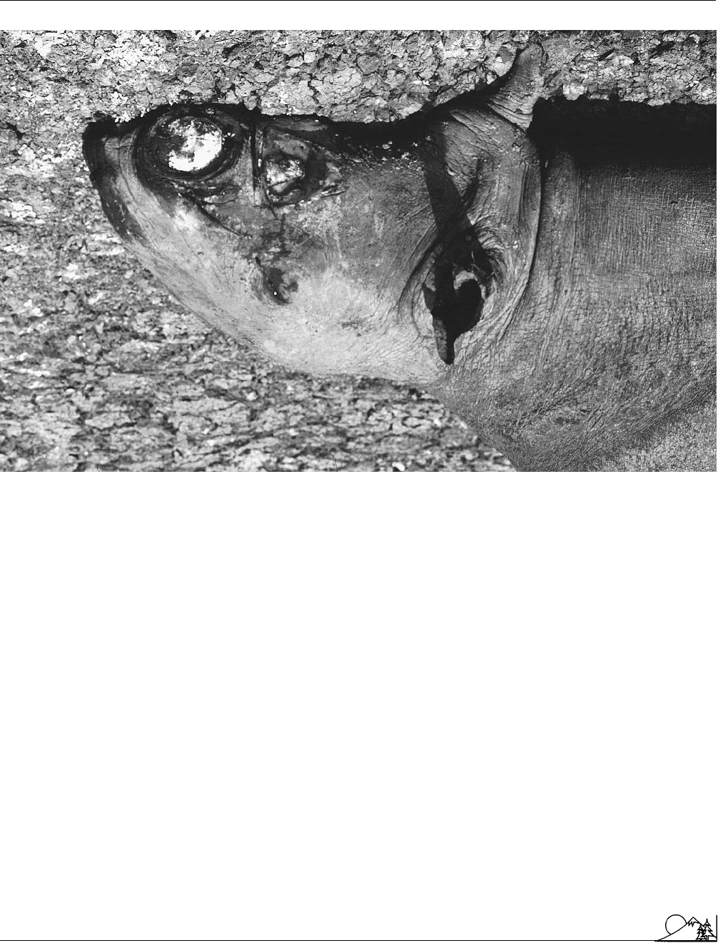
A poached rhinoceros with its horn removed. (Photograph by Warren and Jenny Garst. Tom Stack & Associates. Reproduced
by permission.)
gallbladders are sold for “medicinal” purposes--usually as
tonics to enhance male virility. Poaching also attracts orga-
nized crime because wildlife crime sentences, if tendered,
tend to be lenient and probation requirements are difficult
to enforce.
Poaching has a long history in this country: spot-
lighting a deer at night or shooting a duck in the family
pond for dinner have long been a part of rural life. Today,
despite a 94 percent conviction rate for those caught, poach-
ers feed a demand for wildlife on both domestic and global
markets. They decapitate walruses for ivory tusks, net thou-
sands of night-roosting robins for Cajun gumbo, and shoot
anhingas nesting in the
Everglades
and raptors for decora-
tive feathers.
Wolves
are tracked and shot from airplanes.
Sturgeon and paddlefish are caught and killed for their caviar.
Poaching poses a serious threat to wildlife because it kills
off the biggest and best of a species’
gene pool
. A report
by the Fish and Wildlife Service estimates that 3,600 threat-
ened or
endangered species
receive little or no federal
protection.
1102
The
extinction
of the Labrador duck in the 1880s
and the near extinction of a dozen other waterfowl
species
led to the U.S.-Canadian Migratory Bird Treaty Act of
1918. The enactment of kill limits and the ban on commer-
cial market hunting helped populations of birds. The U.S.
Marine Mammal Protection Act of 1972 makes it a crime
for non-Native Americans to hunt or sell walruses, sea otters,
seals and sea lions
, and polar bears. And the Lacey Act,
passed in 1990, makes it a federal crime to transport illegally
taken wildlife across state lines.
The sale of bear parts is legal in some states, creating
a convenient outlet for poachers. Since merchandise such as
bear meat, galls, and paws is difficult to track, the poachers
are fairly safe. Uniform regulations in all 50 states would
create a more difficult
environment
for poachers to operate
in and might lead to a decrease in poaching, especially of
bears.
As economic and political instability increased in many
developing countries, so did poaching. A global demand for
ivory caused wholesale slaughter of
elephants
and rhinoc-
Environmental Encyclopedia 3
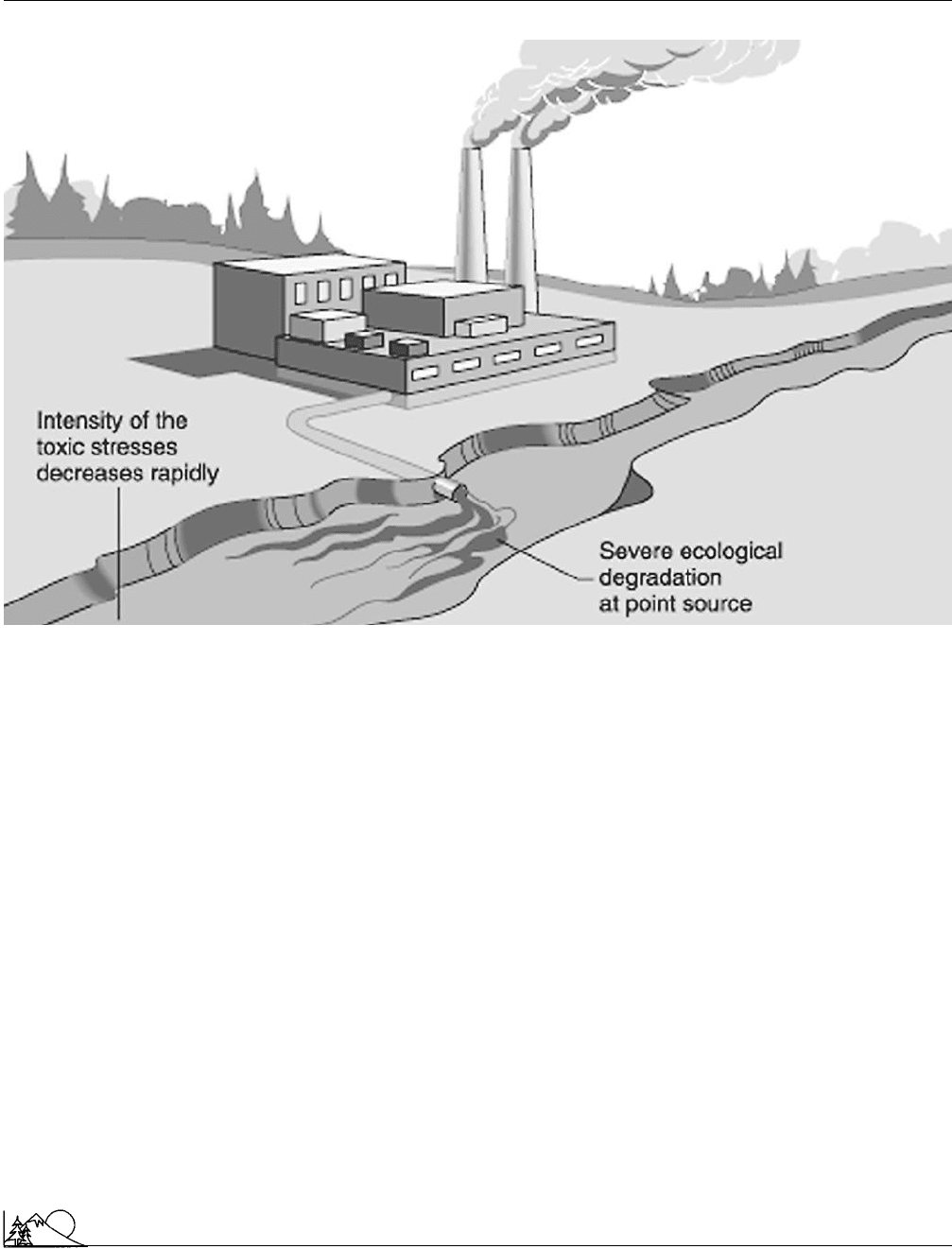
Point source
An example of a point source.
eros. As the big male elephants disappeared, poachers turned
to females, the primary caretakers of the young. To help
stop the carnage of elephant and rhinoceros for their ivory,
105 nations party to the
Convention on International
Trade in Endangered Species of Wild Fauna and Flora
(CITES) have agreed to ban the raw ivory trade. The ban has
caused ivory prices to plummet to pre-1970s levels, making
poaching much less attractive. In Zimbabwe, game wardens
now also have orders to shoot on sight poachers who menace
the rare black rhino. See also Grizzly bear
[Linda Rehkopf]
R
ESOURCES
B
OOKS
Chadwick, D. H. Fate of the Elephant. San Francisco: Sierra Club
Books, 1992.
P
ERIODICALS
Hyman, R. “Check the Fine Print, Mate.” International Wildlife 23 (January-
February 1993): 22–5.
1103
Manry, D., and U. Hirsch. “Cliff-hanger in Morocco.” International Wildlife
23 (March-April 1993): 34–7.
Poten, C. J. “A Shameful Harvest.” National Geographic 180 (September
1991): 106–132.
Point source
A localized, discrete, and fixed contaminant
emission
source, such as a smokestack or waste
discharge
pipe. Since
point sources are usually easily identified, their discharges
of
pollution
can be monitored readily. Point sources are
distinguished from nonpoint sources and mobile (or vehicu-
lar) sources and historically were the first to receive emission
controls. Some point sources release exceptionally large
quantities of contaminants. For example, a
smelter
in
Sud-
bury, Ontario
, was for many years the largest single source
of
sulfur dioxide
in North America, emitting several million
tons of pollutants annually through a smokestack over 1,247
ft (380 m) tall.

Environmental Encyclopedia 3
Poisoning
Poisoning
Poisoning, either from naturally occurring or manmade
chemicals
, can result from ingestion, inhalation, or skin con-
tact with the toxin. It can also be either acute (a one-time,
high amount such as a drug overdose) or chronic (a smaller,
amount over a long period of time, such as
lead
poisoning).
Poisoncontrol centers inmany countries canprovide informa-
tionon treatment andprevention of accidentalpoisoning from
household or industrial products. There are more than 13 mil-
lion known
toxins
, but less than 3,000 cause most incidents
of poisoning. Several practices put in place since the 1950’s
have reduced accidental poisoning by ten-fold. These prac-
tices include the accurate labeling of potentially poisonous
household compounds, and the use of monitoring devices
such as carbon-monoxide detectors. One of the most success-
ful prevention tactics is the use of child-resistant caps on con-
tainers of medicine and household products.
[Marie H. Bundy]
Pollination
Pollination is the process of moving pollen grains, which
contain male sex cells, from the anthers (the pollen-con-
taining part of floral stamens, the male reproductive struc-
ture) of flowers to the stigma (the glandular female receptive
portion) in the pistil (female reproductive organ). When a
pollen grain lands on the female part of the flower, the male
sex cell joins with the female sex cells in the flower in a
process called fertilization to form a seed from which a new
plant can grow. The anthers and stigma can be on the
same flower (self-pollination) or on different flowers (cross-
pollination), but must be of the same
species
. All higher
plants, including flowers, herbs, bushes, grasses, conifers, and
broad-leaved trees, use pollination for sexual reproduction.
Pollination can be accomplished by abiotic means such
as wind and water. Many pollen grains are small (less than
0.05 mm, or 0.002 in). Thus wind can carry the pollen grains
to other members of their species. Many plants, to ensure
pollination, grow in dense stands and produce millions of
pollen grains. Wind-pollinated plants generally have small,
inconspicuous flowers that dangle in the wind (e.g., willow
catkins). Grasses have wispy plume-like flowers that catch
grains floating in the air. Some water plants such as the
hornwort have their pollen transferred by water currents.
Many plants use animals such as insects, birds, and
bats
to transport pollen grains. This process, referred to
as biotic pollination, requires a relationship between the
pollinator and the flower to be pollinated. Such a relationship
is usually established by some kind of direct attractant, such
as nectar, sweet-tasting pollen, odor, or visual attraction
1104
(e.g., brightly-colored flowers). There may also be an indirect
attraction, such as when insects of prey visit flowers to catch
other visiting pollinators.
Insects, including bees, beetles, flies, wasps, ants, but-
terflies, and moths, are common biotic pollinators. As an
insect crawls in and out of flowers in its search for nectar
or other food source, it receives a dusting of pollen grains
from the anther, the male part. When the insect visits an-
other flower, the pollen rubs off on the stigma, the female
part. If the pollen is left on the same species of flower, a
long tube grows from each pollen grain down the stalk (style)
of the stigma and into the ovule at the base, which contains
the female egg cells. The male cells from the pollen grains
pass along the tubes to the female cells and fertilize them.
Plants with trumpet-shaped flowers, such as petunias, have
nectar at the bottom, so only insects with long tube-like
tongues can act as their pollinators.
The best-known and best-adapted biotic pollinator is
the bee. The bee is a relatively large insect with a large
demand for food both for itself and for its carefully looked-
after brood. It normally gets all of its food from flower
blossoms. The bee has an ability to remember plant forms,
which aids in its ability to find flowers. Social bees live
together in a communal nest and often share foraging and
nest activities. The amount of food carried into a hive by
a honeybee has been estimated to be 100 times its own
requirements. Social bees have developed communication
systems that permit them to inform each other about the
location and sources of food. These communication systems
include odor paths, special buzz tones to alert other individu-
als, and dances that can indicate direction, distance to, and
yield of a source of food. However, most of the world’s
40,000 species of bees are solitary. The female bee mates
and then constructs a nest underground or within woody
stems containing many smooth-walled cells. The cells are
filled with a mixture of nectar and pollen, which provides
all the food required for larvae to complete their development
into adult bees.
Biotic pollination may also be accomplished by such
animals as birds and bats. For example, hummingbirds feed-
ing from the hibiscus flower carry pollen on their beak and
heads. Bats hover in front of flowers that open at night,
licking nectar and covering their faces with pollen. Successful
pollination, often mediated by animals but also accomplished
abiotically, is extremely important for food production as
well as maintenance of biological plant diversity. Pollination
of plants is necessary for seed set, fruit yields, and reproduc-
tion of most food crops.
Many threats to animal pollinators and pollination pro-
cesses have been identified. These include use of toxic
chemi-
cals
, decline in pollinator populations,
habitat
loss, and mi-
gratory corridor fragmentation. Toxic chemicals can kill

Environmental Encyclopedia 3
Pollination
pollinators, and wild pollinators are often more vulnerable to
insecticides and herbicides than domestic honeybees. Laws
regulate and control the use of many pesticides during periods
when pollinators are foraging, and use of toxic chemicals near
pollinators’ nesting sites should also be controlled. Pesticides
that are known to be less toxic to pollinators can be used to
reduce stress on pollinator populations. Fewer pollinators will
result in fewer plants. When factors such as the use of pesti-
cides and
habitat fragmentation
reduce populations of pol-
linators, plants will have low reproductive success. Some en-
dangered plant species may even become extinct. Appropriate
pesticide
spraying set-back distances should be based on on-
site determinations made by pollination ecologists familiar
with the plant and pollinator species involved.
Another threat to pollination processes is the decline
in honeybee populations. Since 1990, U.S. beekeepers have
lost one-fifth of their domestic managed honeybee colonies
for reasons that include two kinds of mite infestations, dis-
eases, spraying of pesticides, and several other factors. The
Varroa mite is an external parasite that was identified in the
United States in 1987 and affects bee colonies in thirty states.
This mite lives and feeds on developing bee larvae so that
when the bees hatch, they are small and deformed. Varroa
mites can be controlled by placing medicated plastic strips
inside hives to kill the mites. The bees walk on the strips
and then carry the medicine on their feet to the larvae
growing in the honeycomb. The tracheal mite infects the
respiratory system of adult honeybees. These mites were
found in the United States in 1984 and are now present in
most states. These tracheal mites make bees weak and can
kill an entire colony. To control the mites, an antibiotic
powder, such as terramycin, is mixed into sugar and oil and
is placed inside the bee hive.
Diseases and use of pesticides also take their toll on bee
populations. There are several diseases that can kill bees; these
include American foul brood, chalk brood, European foul
brood, paralysis
virus
, sacbrood disease and kashmir virus.
Some bacterial diseases can be treated by stirring antibiotics
into feed sugar. Often, if a hive is badly infected, the hive
is burned to prevent the infection of other hives. Also, the
spraying of pesticides (e.g., by farmers for crop protection or
by towns and communities for control of mosquitoes) when
bees are foraging can result in their death. Some pesticides
kill bees directly while they are in the crops, while others are
carried back to the hives with the pollen, where they are stored
in the honeycombs. The bees and larvae die when they eat the
pollen, which can be at any time of year. Often the pesticide
does not kill the entire colony, but makes the colony suscepti-
ble to mite infections or freezing in cold weather.
Several other factors have contributed to declining bee
populations.
Africanized bees
, a type of highly defensive
bee that is also known as the killer bee, became established
1105
in the United States in 1990, after years of northward
migra-
tion
from South America where they were first released.
Beekeepers often are forced to abandon their hives when
Africanized bees move into an area. Also, bee populations
that have been weakened by other factors are in danger of
freezing in winter, due to an insufficient number of bees to
provide necessary warmth; or an insufficient supply of food
to convert to heat energy. Finally, loss of agricultural sub-
sidies and price supports in the United States adversely af-
fects the economics of managing bee colonies.
Habitat loss and the severing of migratory corridors
also constitute threats to animal pollinators and pollination
processes. Habitat fragmentation is the division of natural
ecosystems into smaller areas due to land conversion for
agriculture, forestry, and urbanization. As habitat areas be-
come smaller and widely scattered, they may be insufficient
to provide an adequate diversity of host plants and nectar
sources that their pollinators require. Habitat fragmentation
may also cause reduction in pollinator populations due to
loss of nesting habitats. Ecologists need to monitor popula-
tions of pollinators and habitat fragmentation trends to de-
termine possible causes of pollinator decline and to develop
land use
plans to protect pollinator populations such as
maintenance of habitat set-asides or greenbelts near agricul-
tural fields and timber areas.
Thesevering of migratorycorridors can alsodisrupt pol-
lination processes. Some pollinating animal species, such as
nectarivorous bats, navigate through a variety of nectar-pro-
viding plants as they migrate from tropical to
arid
and tem-
perate environments. A bat species may utilize a single type
of flower in each local
environment
, but a series of plants
are linked into a nectar corridor of successive flowering times
along the bat’s migration route. For example, a type of long-
nosed bat flies a loop of 3,200 mi (5,152 km) to follow the
sequential flowering of at least 16 flowering plants species,
including tree morning glories, several century plants, and gi-
ant columnar cactus. Severing of migratory corridors by habi-
tatand vegetation destructionor by sprayingof toxic pesticides
mayadversely affect the success of themigration. For example,
migratory monarch butterflies require critical habitats
through their migratory cycle and can be affected if habitat is
lost due to activities such as development. Monitoring of
plant/pollinator changes in migratory corridors is required to
develop appropriate protection strategies.
[Judith L. Sims]
R
ESOURCES
B
OOKS
Buchmann, S. L., and G. P. Nabhan. Forgotten Pollinators. Washington,
DC: Island Press, 1996.
Faegri, K., and L. van der Pijl. The Principles of Pollination Ecology, 3rd ed
(revised).

Environmental Encyclopedia 3
Pollution
Meeuse, R. J. D. The Story of Pollination. New York: Ronald Press, 1961.
Pollution
Pollution can be defined as unwanted or detrimental changes
in a natural system. Usually, pollution is associated with the
presence of toxic
chemicals
in some large quantity, but
pollution can also be caused by the presence of excess quanti-
ties of heat or by excessive fertilization with nutrients.
Because pollution is judged on the basis of degradative
changes, there is a strongly anthropocentric bias to its deter-
mination. In other words, humans decide whether pollution
is occurring and how bad it is. Of course, this bias favors
species
, communities, and ecological processes that are es-
pecially desired or appreciated by humans. In fact, however,
some other, less-desirable species, communities, and ecologi-
cal processes may benefit from what we consider pollution.
An important aspect of the notion of pollution is that
ecological change must actually be demonstrated. If some
potentially polluting substance is present at a concentration
or intensity that is less than the threshold required to cause
a demonstrable ecological change, then the situation would
be referred to as contamination, rather than pollution.
This aspect of pollution can be illustrated by reference
to the stable elements, for example,
cadmium
,
copper
,
lead
,
mercury
,
nickel
, selenium,
uranium
, etc. All of these
are consistently present in at least trace concentrations in
the
environment
. Moreover, all of these elements are poten-
tially toxic. However, they generally affect biota and there-
fore only cause pollution when they are present at water-
soluble concentrations of more than about 0.01 to 1
parts
per million
(ppm).
Some other elements can be present in very large con-
centrations, for example,
aluminum
and iron, which are
important constituents of rock and
soil
. Aluminum consti-
tutes 8-10 percent of the earth’s crust and iron 3-4 percent.
However, almost all of the aluminum and iron present in
minerals are insoluble in water and are therefore not readily
assimilated by
biotic community
and cannot cause toxicity.
In acidic environments, however, ionic forms of aluminum
are solubilized, and these can cause toxicity in concentrations
of less than one part per million. Therefore, the bio-availabil-
ity of a chemical is an important determinant of whether
its presence in some concentration will cause pollution.
Most instances of pollution result from the activities
of humans. For example,
anthropogenic
pollution can be
caused by:
O
the
emission
of
sulfur dioxide
and metals from a
smelter
,
causing toxicity to vegetation and acidifying surface waters
and soil,
1106
O
the emission of waste heat from an electricity generating
station into a river or lake, causing community change
through thermal stress, or
O
the
discharge
of nutrient-containing sewage wastes into
a water body, causing eutrophication.
Most instances of anthropogenic pollution have natu-
ral analogues, that is, cases where pollution is not the result
of human activities. For example, pollution can be caused
by the emission of sulfur dioxide from volcanoes, by the
presence of toxic elements in certain types of soil, by thermal
springs or vents, and by other natural phenomena. In many
cases, natural pollution can cause an intensity of ecological
damage that is as severe as anything caused by anthropogenic
pollution. (This does not, of course, in any way justify an-
thropogenic pollution and its ecological effects.)
An interesting case of natural
air pollution
is the
Smoking Hills, located in a remote and pristine
wilderness
in the Canadian Arctic, virtually uninfluenced by humans.
However, at a number of places along the 18.63 miles (30
km) of seacoast, bituminous shales in sea cliffs have sponta-
neously ignited, causing a
fumigation
of the
tundra
with
sulfur dioxide and other pollutants. The largest concentra-
tions of sulfur dioxide (more than two parts per million)
occur closest to the combustions. Further away from the sea
cliffs the concentrations of sulfur dioxide decrease rapidly.
The most-important chemical effects of the air pollution are
acidification
of soil and fresh water, which in turn causes
a solubilization of toxic metals. Surface soils and pond waters
commonly have pHs less than 3, compared with about
pH
7 at non-fumigated places. The only reports of similarly
acidic water are for volcanic lakes in Japan, in which natural
pHs as acidic as 1 occur, and pH less than 2 in waters
affected by
drainage
from
coal
mines.
At the Smoking Hills, toxicity by sulfur dioxide, acid-
ity, and water-soluble metals has caused great damage to
ecological communities. The most-intensively fumigated
terrestrial sites have no vegetation, but further away a few
pollution-tolerant species are present. About one kilometer
away the toxic stresses are low enough that reference tundra
is present. There are a few pollution-tolerant algae in the
acidic ponds, with a depauperate community of six species
occurring in the most-acidic (pH 1.8) pond in the area.
Other cases of natural pollution concern places where
certain elements are present in toxic amounts. Surface miner-
alizations can have toxic metals present in large concentra-
tions, for example copper at 10 percent in peat at a copper-
rich spring in New Brunswick, or surface soil with three
percent lead plus zinc on Baffin Island. Soils influenced by
nickel-rich serpentine minerals have been well-studied by
ecologists. The stress-adapted plants of serpentine habitats
form distinct communities, and some plants can have nickel
concentrations larger than 10 percent in their tissues. Simi-