Flechtner F.M., Gruber Th., G?ntner A., Mandea M., Rothacher M., Sch?ne T., Wickert J. (Eds.) System Earth via Geodetic-Geophysical Space Techniques
Подождите немного. Документ загружается.

Validation of Satellite Gravity Field Models 281
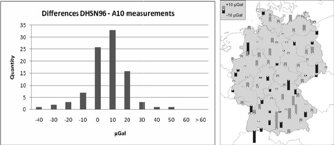
Fig. 2 Left: Histogram of differences between A-10 observations and DHSN96 1st order net-
work gravity values; Right: Spatial distribution of differences between A-10 absolute gravity
observations and corresponding values from DHSN96 1st order network in Germany
could not be placed directly above the intended measurement point. In these cases
eccentric observations were connected to the corresponding bench marks using rel-
ative measurements as well. The necessary height transfer from the absolute sites to
the DHSN96 bench marks was done by spirit levelling.
In order to evaluate the accuracy of the DHSN96 1st order gravity network, the
gravity values were compared with the observed A-10 absolute gravity values at 93
field stations, measured during the GOCE-GRAND II project (7 points were left
out due to instrumental problems or environmental issues). The differences between
the A-10 and DHSN96 gravity values (which are influenced by observation errors
of the A-10 absolute and CG-5 relative gravimeter as well as by the errors of the
DHSN96 values themselves) show a mean of ±0.2 μGal and a standard deviation
of ±18.7 μGal (see Fig. 2). About 90% of the measured points differ by not more
than 20 μGal from the DHSN96 values. With the results presented above, the accu-
racy estimates for the DHSN96 network were confirmed, and thus no systematic
impacts on geoid modelling have to be worried about. The quality of subordinate
networks or independent data sets is still questionable and requires further inves-
tigations. Regarding the source, measurement method, accuracy and homogeneity,
the existing data base includes a variety of different data sets. A proper weighting
strategy of these different data sets in the course of the quasigeoid modelling should
be derived from this evaluation in the future.
Furthermore, the existing gravity data base, e.g., used for the computation of the
national quasigeoid model GCG05 (German Combined QuasiGeoid 2005; Liebsch
et al., 2006), was validated by the new A-10 absolute gravity observations. For this
purpose, Bouguer anomalies were predicted from the GCG05 data base, which
were then compared with corresponding values for the A-10 stations. However,
since the accuracy of the predicted values is two orders of magnitude worse than
the accuracy of the absolute measurements, meaningful conclusion appear to be
impossible.

282 J. Ihde et al.
3 GPS and Levelling Data
GPS and levelling data are essential in two respects. First, they are important for the
direct validation of global gravity field models including the ones from the GOCE
mission, and secondly they can be used for cross-validating astrogeodetic and gravi-
metric geoid and quasigeoid models. Moreover, the GPS and levelling data can be
combined with the aforementioned data sets. In this context, the fitting of gravimet-
ric geoid and quasigeoid models to GPS and levelling control points has become
a standard procedure for GPS height determination with a targeted accuracy of
about 1 cm.
In Germany, a national GPS and levelling data was collected by BKG, consist-
ing of 907 stations with a spacing of 25–30 km. The GPS coordinates are based on
the re-adjusted SAPOS reference station coordinates, which were introduced at the
beginning of 2004 (Beckers et al., 2005). However, the Federal States of Germany
used individual procedures to implement the new SAPOS reference frame, rang-
ing from re-observation and re-adjustment to different transformation procedures,
which may have introduced some inhomogeneities in the GPS coordinates. The
gravity field related heights are normal heights referring to the official DHHN92
system (AdV, 1995). For further details cf. Liebsch et al. (2006). In this context,
future improvements will result from the renewal of the German 1st order level-
ling network until 2011 in connection with a parallel GNSS observation campaign
in 2008.
The German GPS/levelling data set was compared with the global geopotential
models EGM1996 (Lemoine et al., 1998), EGM2008 (Pavlis et al., 2008) and sev-
eral models developed at the Helmholtz Centre Potsdam, GFZ German Research
Centre for Geosciences (ICGEM, 2009). All geopotential models include terres-
trial gravity and satellite altimeter data in combination with satellite observations.
Apart from EGM1996, all other models are based on data from the GRACE mission.
Table 1 provides the statistics of the differences between the German GPS/levelling
data set and the above mentioned geopotential models. In all cases, a constant bias
was subtracted from the differences in order to account for different zero levels and
very long wavelength errors in all data sets involved (GPS, levelling, quasigeoid).
Table 1 Comparison of 907 GPS and levelling stations in Germany with different global
geopotential models. A constant bias is subtracted. Units are m
Geopotential model Maximum degree used RMS Min Max
EGM1996 360 0.251 –0.588 +1.187
EGM2008 360 0.135 –0.552 +0.663
EGM2008 2,190 0.030 –0.107 +0.144
EIGEN-CG01C 360 0.211 –0.734 +0.693
EIGEN-CG03C 360 0.189 –0.723 +0.704
EIGEN-GL04C 360 0.180 –0.736 +0.724
EIGEN-5C 360 0.153 –0.541 +0.756
Validation of Satellite Gravity Field Models 283
From the models to spherical harmonic degree 360, EGM2008 performs best with
a RMS difference of 0.135 m, while the latest EIGEN-5C models yields a RMS
difference of 0.153 m, compared to 0.251 m for EGM1996. This shows the signif-
icant improvements due to the inclusion of the GRACE data but also due to the
improved terrestrial data sets. Regarding the EIGEN models f rom GFZ, it can be
observed that the results improve with time and the inclusion of GRACE data over a
longer time period. Finally, with the EGM2008 model to degree 2,190, a RMS dif-
ference of only 0.030 m is obtained, which is close to the best regional quasigeoid
models.
4 Gravimetric Quasigeoid Models
The computation of regional high-resolution geoid and quasigeoid models is com-
monly based on the remove-restore technique, combining terrestrial gravity data
(with a spacing of a few km), a detailed digital terrain model (with a grid size
down to 30 m) and a global geopotential model. In this context, the global geopo-
tential model and the regional data sets complement each other in a favorable
manner, i.e., the global model provides the long wavelength gravity field structures
with high accuracy, while the regional data sets contribute the medium and short
wavelength gravity field components, which are not included in the global model.
Up-to-date global geopotential models are based on the GRACE satellite mission
(e.g., EGM2008; Pavlis et al., 2008) and provide the global geoid with an unprece-
dented accuracy of about 1 mm to spherical harmonic degree 40 and 1 cm to degree
80. On the other hand, high quality regional terrestrial gravity field data sets exist in
several parts of the world and can be combined with a global model. In the combi-
nation approach, e.g., least-squares collocation or spectral combination techniques,
the signal and error characteristics of all involved data sets have to be taken into
account. As a result, the long wavelength components of the regional geoid and
quasigeoid models and of the global geopotential model match to a great extent.
Therefore, comparisons of regional geoid and quasigeoid models with GPS/levelling
data can be regarded also as a validation tool for the underlying global geopotential
models.
In the following, the high resolution European quasigeoid models derived within
the framework of the European Gravity and Geoid Project (EGGP) are considered
as representative examples (cf. Denker et al., 2009). The latest model EGG2008
was computed on the basis of the 2008 European gravity and terrain data sets
and the EGM2008 global model, utilizing the spectral combination approach. In
order to show the improvement with time, the 2008 terrestrial data was also
combined with other recently published global models as well as the EGM1996
model (Lemoine et al., 1998). In addition, the previous European quasigeoid model
EGG1997 is considered as a reference. All results were evaluated by comparisons
with the German GPS/levelling data set. Table 2 shows the statistics of differ-
ences between the GPS/levelling data and different European quasigeoid models.
A constant bias was subtracted from the differences. First, the results based on
284 J. Ihde et al.
Table 2 Comparison of 907 GPS and levelling stations in Germany with different quasigeoid
models. A constant bias is subtracted. Units are m
Terrestrial data Underlying geopotential model RMS Min Max
1997 (EGG1997) EGM1996 0.094 –0.185 +0.327
2008 EGM1996 0.072 –0.132 +0.296
2008 EIGEN-CHAMP03S 0.049 –0.118 +0.258
2008 EIGEN-GRACE01S 0.038 –0.113 +0.148
2008 EIGEN-GRACE02S 0.037 –0.081 +0.119
2008 EIGEN-GL04S1 0.028 –0.096 +0.082
2008 EIGEN-5S 0.027 –0.097 +0.070
2008 EIGEN-5C 0.027 –0.098 +0.073
2008 (EGG2008) EGM2008 0.026 –0.090 +0.074
EGM1996 show that the updated terrestrial data sets improve the results; the RMS
difference reduces from 0.094 m for the 1997 terrestrial data to 0.072 m for the
2008 data. Then further significant improvements can be found when using a
CHAMP based model (EIGEN-CHAMP03S, 0.049 m RMS) and the GRACE based
EIGEN and EGM2008 models. It can be observed that the GRACE based models
improve with time with the recent EIGEN-5C/S and EGM2008 models resulting in
a RMS difference of 2.7 and 2.6 cm, respectively. In total, this is a very significant
improvement of more than 70%, as compared to the previously published EGG1997
quasigeoid model. Hence, the new satellite mission data have a significant impact on
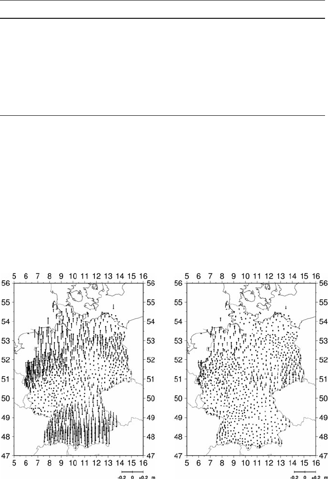
Fig. 3 Comparison of 907 GPS and levelling stations in Germany with the quasigeoid solutions
EGG1997 (left part) and EGG2008 (right part). A constant bias is subtracted. Stations (dots)and
differences (positive: up; negative: down) are depicted
Validation of Satellite Gravity Field Models 285
the performance of the r egional quasigeoid models and further improvements down
to the level of about 1 cm can be expected from the GOCE mission. However, on
the other hand, also the quality of the terrestrial data sets is of vital importance. In
the end, Fig. 3 depicts the differences between the German GPS/levelling data set
and the EGG1997 and EGG2008 gravimetric quasigeoid models.
Furthermore, the GPS/levelling data can be included as input data in the quasi-
geoid modelling. This was done in Germany and lead to the combined GCG2005
quasigeoid model (Liebsch et al., 2006). This model was developed as a joint effort
of BKG and IfE and serves as a standard in Germany for the conversion between
GPS ellipsoidal heights and normal heights. The evaluation of the model with inde-
pendent GPS and levelling points suggested an accuracy of about 1–2 cm (Liebsch
et al., 2006).
5 Astrogeodetic Vertical Deflections
In recent years, a new generation of zenith camera systems has become available
for the determination of astrogeodetic vertical deflections. The increased accuracy
of 0.1
or better (Hirt, 2004) and the automation of the vertical deflection processing
are the main improvements. Two very similar zenith camera systems exist in Europe,
namely the TZK2-D at IfE (Hirt, 2004) and DIADEM at ETH Zurich (Bürki et al.,
2004). After an extensive test phase, both systems were applied in high-resolution
gravity field modelling investigations. The TZK2-D was employed extensively in
the local validation of gravimetric geoid models along profiles in the German Alps
(Hirt and Flury, 2007) and in the Harz Mountains (Hirt et al., 2008). The results
showed the great accuracy potential of the astrogeodetic vertical deflections within
local test areas.
Within the framework of the GOCE-GRAND II project, the IfE zenith cam-
era system TZK2-D was employed in extensive campaigns to collect vertical
deflections on longer profiles of several hundred kilometres length (regional
scales), aiming at an independent regional validation of other gravity field data
sets such as GPS/levelling data, regional quasigeoid models or global geopo-
tential models. Between 2006 and 2008, astrogeodetic vertical deflections were
determined on 148 stations along a North-South profile and on 134 stations
along an East-West profile. The observations were collected during 54 nights in
total.
Both profiles have a spacing of about 2.5–5 km between adjacent stations, result-
ing in a total length of 540 km (North–South) and 533 km (East–West), respectively.
In addition, astrogeodetic vertical deflections observed within previous projects
(Hirt and Flury, 2007; Hirt et al., 2008) were embedded in the North-South profile,
resulting in a unique data set of in total 498 highly accurate astrogeodetic vertical
deflections (see Fig. 1, right). Due to the high degree of automation of the TZK2-
D system, up to 12 vertical deflection stations could be observed in a single night,
but it should also be pointed out that unfavourable nightly weather conditions may
significantly limit the efficiency of the astronomical observation technique.

286 J. Ihde et al.
In order to assess the quality of the astrogeodetic vertical deflections, repeated
observations were carried out at 48 identical stations in different nights. The stan-
dard deviation of the differences was found to be 0.16
for both ξ and η. However,
these values were affected by observations with a reduced accuracy due to worse
weather conditions, e.g. fog; after excluding corresponding observations from the
analysis, the repeatability agrees well with the stated accuracy of 0.1
for the
TZK-2D system (Hirt, 2004). Furthermore, vertical deflection determinations and
calibrations were carried out regularly at the IfE astronomic reference station in
Hannover (Hirt and Seeber, 2007) in order to verify the instrumental stability.
5.1 Astrogeodetic Validation of GPS/Levelling Data
and Gravimetric Quasigeoid Models
In order to allow a cross-validation with the national GPS/levelling data set, the
astrogeodetic profiles traverse through 46 nearby GPS/levelling control points in
total (see Fig. 1). The method of astronomic levelling was used to compute quasi-
geoid height differences (Torge, 2001). In this context, a digital terrain model with
agridsizeof1
× 1
was utilized in order to smooth the observed vertical deflec-
tion data (Voigt and Denker, 2007). The accuracy estimate for the quasigeoid height
difference over an entire profile length of more than 500 km is 2.2 cm, implying
random noise with a magnitude of 0.1
for the vertical deflection data and neglecting
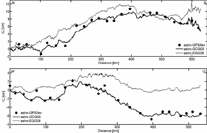
omission errors. The results of the comparisons between the astrogeodetic quasi-
geoid profiles and the GPS/levelling data as well as the gravimetric quasigeoid
models German Combined QuasiGeoid 2005 (GCG05; Liebsch et al., 2006) and
the European Gravimetric Quasigeoid 2008 (EGG2008; Denker et al., 2009) are
shown in Table 3 and Fig. 4. Since the astrogeodetic method only provides differ-
ences of height anomalies, the absolute l evel is taken from the GCG05 model at the
first station.
The cross-validation of the astrogeodetic results, based on the method of astro-
nomic levelling, with GPS/levelling and gravimetric quasigeoid data revealed partly
systematic differences in the order of a few cm over some 100 km length (Voigt
et al., 2009), which could not be fully explained so far, although repeat and densifi-
cation observations were carried out with the TZK2-D instrument. Possible reasons
for the discrepancies in the cross-validation may be inhomogeneities in the GPS
Table 3 Statistics (cm) of the differences ζ between the astrogeodetic quasigeoid heights and
GPS/levelling as well as gravimetric models along the North–South and the East–West profile
North–South profile East–West profile
Data set No Std Min Max No Std Min Max
GPS/lev 23 3.5 −1.3 10.7 23 2.7 –6.8 2.1
GCG05 364 3.4 −1.1 9.9 134 2.6 –6.3 2.0
EGG08 364 4.3 0.0 12.3 134 1.4 –0.6 4.0
Validation of Satellite Gravity Field Models 287
Fig. 4 Comparison of the astrogeodetic quasigeoid solution with GPS/levelling and quasigeoid
models GCG05 and EGG2008 along the North–South profile (top) and the East–West profile
(bottom)
results due to different processing strategies used in the individual Federal States of
Germany (ranging from re-observation and re-adjustment to different transforma-
tion procedures), systematic effects or insufficient spacing of the vertical deflection
observations, and to some extent also large-scale levelling errors. It is manda-
tory to further study and enlighten the reasons for the discrepancies by additional
observations, data re-processing and development of realistic error models.
5.2 Astrogeodetic Validation of Global Geopotential Models
The main difference between the astrogeodetic vertical deflections and correspond-
ing values derived from a global geopotential model (GGM) is the different spectral
content. Whereas the GGM deflections have only a limited spectral content due to
the limited degree of the spherical harmonic series, the astrogeodetic deflection data
contain the complete spectrum (all frequencies).
In order to filter out all high-frequency signals from the terrestrial data, which
are not included in the GGM (i.e. outside the measurement bandwidth with regard to
GOCE), the Gaussian filter technique was applied with a radius of 50 km. Due to the
delay of the GOCE mission, the analyses were carried out using the currently avail-
able models EGM96 (Lemoine et al., 1998), EIGEN-GL04C (Förste et al., 2008a)
and the ultra-high degree model EGM2008 (Pavlis et al., 2008). Figure 5 shows the
unfiltered and Gaussian filtered differences of the vertical deflection components ξ
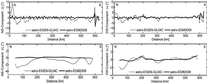
288 J. Ihde et al.
Fig. 5 Comparison between the unfiltered (top) and Gaussian filtered (bottom) astrogeodetic and
GGM vertical deflection components ξ and η along the North–South profile
and η along the North–South profile. The comparisons with the models EGM96 and
EIGEN-GL04C show RMS values from 1.7
to 2.8
for the unfiltered differences
and 0.8
–2.1
for the Gaussian filtered values, with mean values of 1.0
or below.
The validation of the ultra-high degree model EGM2008 shows RMS values from
0.6
to 1.2
for the unfiltered differences – slightly better than the RMS differences
of 1.1
to 1.3
in CONUS (Contiguous United States) and Australia (Pavlis et al.,
2008) – and 0.1
to 0.3
for the Gaussian filtered values, with mean differences of
0.2
or below. These results confirm the high accuracy level of the EGM2008 model
and show that the astrogeodetic vertical deflections are suitable for an external and
completely independent validation of the GGM data.
6 Global Model Validation by Wavelet Techniques
In general there are two kinds of gravity field validation. The first one is a global
approach: the gravity field covering the whole Earth is compared to another global
gravity field. Both fields are spectrally band limited. There are some well-known
techniques to filter and to estimate the errors introduced by the chosen filter.
The second approach is to compare a global gravity field with regional point
observations, covering only a small part of the Earth. These two data sets are not
compatible. The global gravity field is spectrally band limited, while the local obser-
vations are not. Thus, validation has to be performed on the observation points and
it has to be band-limited by low pass filtering the terrestrial validation data set.
Apart from the filtering, additional uncertainties in such a validation process might
result from the data combination technique and regularization method applied in the
global (GOCE) gravity field analysis and from possible datum off-sets, biases and
trends in the terrestrial validation data sets. Because available data sets cover only a
small part of the Earth, validation results might not be representative for the globe
and long wavelengths of the global model might not be well represented in the test
data sets.

Validation of Satellite Gravity Field Models 289
Table 4 Available GPS/levelling data sets
Country/continent Number of points References
Australia 197 Johnston and Manning (2003, personal communication)
Canada 430 Verroneau (2007, personal communication)
Europe 1,233 Kenyeres et al. (2006)
Germany 675 Ihde and Sacher (2002)
Japan 837 Nakagawa (2003, personal communication)
USA 5,167 NGS (1999)
For all approaches it is necessary to use data sets of sufficient consistency
and precision for the global model validation. Astrogeodetic vertical deflections
(see Sect. 5) and GPS/levelling observations (see Sect. 3) are natural candidates
for this. In the following study, GPS/levelling heights in different areas of the
world are applied for validating global models. In particular it is referred to the
German GPS/levelling observations described in Sect. 3. As already pointed out,
it is expected that GOCE gravity field models will have a precision of a few cen-
timeters in geoid height with a resolution of 100 km or better. Hence, the regional
data must have the same or even better precision. As a further requirement for a
satisfactory validation there should exist different data sets evenly spread over the
whole Earth. Table 4 specifies the GPS/levelling geoid height data sets applied for
GOCE gravity field validation. As one can see in Table 4, only very few data sets are
available for validation. Especially there are no test data in South America, Africa
and most parts of Asia.
The input data and the results of this work will be stored in a newly designed
validation database. This database is able to store all validation data as well as the
GOCE gravity field results. It is hosted on a server at IAPG. A second server is
used as a web interface to the database. With the web interface one can access all
data in the validation database. The interface assists the user by showing only those
data sets that match the selections already made. As a last step, the data can be
downloaded in various graphical and textual formats.
6.1 Filtering Terrestrial Data by Second Generation Wavelets
The calculation of global gravity fields is commonly done with spherical harmon-
ics. They have a lot of well-known advantages for computing global fields, but for
locally bounded problems this globality is a disadvantage, because spherical har-
monics cannot be restricted in frequency and space simultaneously without loss of
accuracy. As mentioned before, in order to make both data sets compatible, it is nec-
essary to filter regional data with respect to the frequency content, because the global
field is band limited in the frequency domain. There are several filter techniques to
achieve this: Least-Square-Collocation (LSC), Spherical-harmonic synthesis (SHS)
with ultra-high degree spherical harmonic models and second generation wavelets
(SGW). The latter approach is described in the following paragraphs.
290 J. Ihde et al.
Wavelets can filter a data set in the frequency and space domains simultane-
ously. This makes wavelets suitable for filtering regional data in order to compare
them with global models. Usually wavelets rely on regularly spaced data because
of an underlying Fourier transform, requiring a regular grid of data. To apply a
wavelet transform to GPS/levelling data, the data would have to be interpolated to
this regular grid. However, interpolating data can add aliasing to data and removes
(mainly high-frequency) information (Soltanpour et al., 2006). To avoid this inter-
polation, Sweldens (1998) developed wavelets usable f or irregular spaced data, the
so called second generation wavelets (SGW). Besides the ability to work on irreg-
ular data, there are some other differences to “normal” wavelets: First generation
wavelet functions are dyadic translations and dilations of one mother wavelet
ψ
j,m
(x) = ψ (2
j
x −m).
So each wavelet ψ
j,m
at a level j and location m can be retrieved from the mother
wavelet ψ. This is not possible with second generation wavelets. In terms of signal
processing this means that the new wavelets have different filter characteristics for
each level depending on the underlying data.
In a first step, the wavelet coefficients have to be determined. In general one needs
to know the neighbours of each calculation point. With one-dimensional calculation,
only the direct neighbours have to be taken into account. With two dimensional data,
the determination of the neighbourhood of each vertex is not a trivial task anymore.
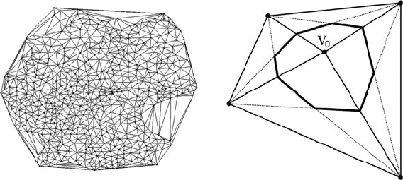
In this work, the Delaunay triangulation (Fig. 6 left) is used for this purpose as
proposed by Delouille et al. (2006).
To determine the area of support of the scaling functions, the Voronoi polygons
(Fig. 6 right) have to be built for each vertex. At the finest level, the integral of
the scaling functions is initialized with the area of the Voronoi polygon around the
vertex it was calculated for, i.e. v
0
. After that, the vertex with the smallest area is
removed, the surrounding vertices are updated to keep the support constant, and
the triangulation has to be partly rebuilt. On each level, only one new wavelet
coefficient is calculated for a vertex. These steps are repeated until only bound-
ary vertices remain. Figure 7 shows the calculated coefficients. In this case, the first
Fig. 6 Delaunay triangulation