Flechtner F.M., Gruber Th., G?ntner A., Mandea M., Rothacher M., Sch?ne T., Wickert J. (Eds.) System Earth via Geodetic-Geophysical Space Techniques
Подождите немного. Документ загружается.

Validation of Satellite Gravity Field Models 291
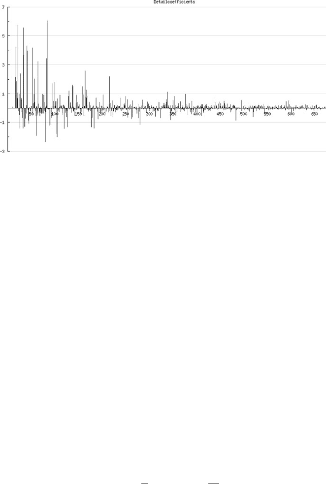
Fig. 7 Wavelet detail coefficients. x-axis shows the level of wavelet coefficient, y-axis shows the
difference in height between vertex and the plane through the surrounding vertices
16 coefficients are not shown because they are located on the border and so it was
not possible to determine surrounding vertices.
The coefficients are sorted by level. The coefficients of the finest level (i.e. the
observations) with the smallest area support are shown on the right, those of the
coarsest level on the left. The smaller these coefficients are, the smoother is the
underlying data. The coefficients are the differences of the observations to a least
squares plane through the surrounding vertices. This step is called prediction. There
are several ways to determine this plane. In this work, a least-squares prediction
of order one is used, as proposed in Jansen et al. (2001). Delouille et al. (2003,
2006) describe several other prediction operators. Besides the wavelet coefficients,
the prediction provides a weight matrix. The weight matrix shows the relationship
between the predicted vertex and its surrounding vertices. It is possible to display
this matrix in a banded structure. For that purpose the vertices have to be sorted by
their coordinates. This depicts the localizing effect of this wavelet transformation as
only correlated vertices have values not equal to zero.
For de-noising the data (i.e. low pass filtering in terms of wavelets), the small-
est coefficients are replaced by zeros. Therefore, the reconstructed signal will
only consist of the remaining coefficients. This step is called thresholding. It is
very important to find an optimal threshold value. A small threshold value will
leave noise in the data, while a large value could remove parts of the signal. To
find the optimal threshold value, Jansen et al. (1997) proposed the generalized
cross-validation (GCV) function:
GCV(λ) =
#
1
N
˜ω −˜ω
λ
2
$#
N
0
N
$
−2
In this equation ˜ω is the vector of normalized coefficients, ˜ω
λ
is the vector
of thresholded normalized coefficients and N
0
/N is the fraction of coefficients
292 J. Ihde et al.
replaced by zero for a particular threshold value λ. In most cases, this function has a
minimum. This minimum is the optimal threshold value. It also minimizes the mean
square error of the result as compared to the noise free coefficients.
To use this function, the wavelet coefficients have to be normalized as the noise
standard deviation is different for each coefficient, as shown in Jansen et al. (1997).
This is done by using the correlation matrix of the input. In case of GPS/leveling
data, this matrix is often not known but can be approximated by their covariance
function. This might fail if the GCV function does not have a minimum. In this case
one must choose another appropriate threshold value. All coefficients with a value
below the minimum of the GCV will be set to zero. In a last step, the vertices will be
reproduced.
6.2 First Results with Second Generation Wavelets
While LSC and SHS use a fixed order for filtering, with SGW the optimal filter limit
only depends on the data. In case of SGW, there are two possible ways to validate:
Filtering before or after building differences. In the first case, both data sets must
be filtered on their own. Each data set will have its own coefficients and threshold
value. In the second case, there will be only one set of coefficients and one threshold
value.
While filtering after building differences has the advantage of a faster calculation,
filtering before building differences has some advantages that make it preferable. In
case of filtering after building differences some signal might be filtered out which is
relevant for the validation.
Coefficient comparison can give a first overview about the quality of the data.
Both sets of coefficients must have a high correlation. Different threshold values
will give a hint about the signal-to-noise ratio of both data sets. Especially with the
already band limited global data, a threshold value indicates a high noise level for
that type of data.
The following results are calculated with the German GPS/levelling data set (Ihde
and Sacher 2002) and three different geopotential models. For each model, geoid
heights of each point were calculated. These heights were filtered and compared
point-wise to the filtered measured geoid heights.
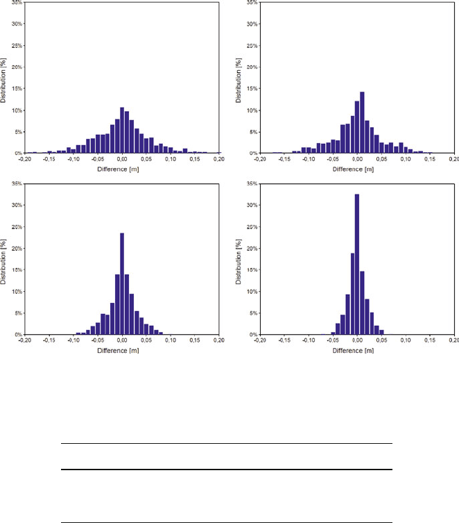
Figure 8 shows the distribution of differences between original and filtered data
for different geoid models. Depending on the maximum degree of the model, the
maximum differences vary between ±0.20 and ±0.07 m. On the one hand, this
shows the different quality of the input data. On the other hand, it demonstrates the
low-pass filtering by the wavelet filter. The less the maximum degree, the less points
were changed by the filter. With this in mind it should be possible to determine the
inherent maximum degree of a data set that depends on the geographical distribution
of the points.
Table 5 shows the resulting RMS, comparing the measured geoid heights
(GPS/levelling) to the three calculated geoid height data sets (geopotential
models).
Validation of Satellite Gravity Field Models 293
Fig. 8 Differences geoid heights original vs. filtered. Measured geoid heights (left top), EGM
2008 to degree 2,160 (right top), EIGEN 5C to degree 360 (left bottom) and EIGEN 5C to degree
200 (right bottom)
Table 5 RMS of centered differences
Model Max. degree RMS (m)
EGM 2008 (Pavlis et al., 2008) 2,160 0.039
EIGEN 5C (Förste et al., 2008b) 360 0.154
EIGEN 5C (Förste et al., 2008b) 200 0.295
Obviously these results are only a first attempt. Because the wavelet filter
depends on the data, some tuning will be necessary when validating real GOCE data.
There are also still several topics for further investigations: It s hould be possible to
determine the degree and order of the filtered data by means of spherical harmonics,
and also the quality of the validation has to be investigated. For this purpose it must
be analyzed which errors can be detected and how they will show up.
7 Conclusions
A regional validation and combination experiment was carried out within the frame-
work of the GOCE GRAND II project and lead to valuable regional terrestrial
gravity field data sets, including gravity data, GPS and levelling control points,
294 J. Ihde et al.
astrogeodetic vertical deflections and gravimetric quasigeoid models. Spot-checks
with the A-10 absolute gravimeter have proved the high quality of the existing
terrestrial gravity data base for Germany. The detected gravity differences are
insignificant with regard to geoid and quasigeoid computations with an envisaged
accuracy level of about 1 cm. The astrogeodetic observations and GPS/levelling
data are completely independent of all other gravity field data sets. Therefore they
are very valuable for manifold validation purposes.
The existing GPS/levelling quasigeoid heights are not yet at the 1 cm accuracy
level. Reasons for this are the inhomogeneities of the three-dimensional coordinates,
especially the ellipsoidal heights, resulting from different measurement epochs and
processing schemes within the Federal States of Germany, but also the levelling may
contribute to this. With regard to the renewal of the German 1st order levelling net-
work until 2011 and the parallel GNSS campaign 2008, considerable improvements
are expected.
Approximately 300 astrogeodetic vertical deflections with an accuracy of about
0.1
were collected. This data set is independent of the other terrestrial data sets and
can be considered as unique worldwide. However, the cross-validation with GPS
and levelling data and gravimetric quasigeoid models revealed partly systematic
differences in the order of several cm over a few 100 km length, which could not
be fully explained within this project. The validation of GGM vertical deflections,
however, showed the high accuracy potential of the astrogeodetic data. Hence, they
can be used as another independent external validation tool for GOCE data, taking
into account a reasonable low-pass filtering of the surface data.
With regard to the gravimetric quasigeoid models, the new satellite mission data
have a significant impact on the performance. Further improvements down to the
level of about 1 cm can be expected from the GOCE mission.
References
AdV (1995) Deutsches Haupthöhennetz 1992 (DHHN 92). Arbeitsgemeinschaft der
Vermessungsverwaltungen der Länder der Bundesrepublik Deutschland (AdV). Bayerisches
Landesvermessungsamt München.
Beckers H, Behnke K, Derenbach H, Faulhaber U, Ihde J, Irsen W, Lotze J, Strerath M (2005)
Diagnoseausgleichung SAPOS – Homogenisierung des Raumbezugs im System ETRS89 in
Deutschland. ZFV 130(4), 203–208.
Bouman J, Koop R (2003) Geodetic methods for calibration of GRACE and GOCE. Space Sci.
Rev. 108, 293–303.
Bürki B, Müller A, Kahle H-G (2004) DIADEM: the new digital astronomical deflection measuring
system for high-precision measurements of deflections of the vertical at ETH Zurich. IAG
GGSM 2004, Porto, Portugal, CD-ROM Proceedings.
Delouille V, Jansen M, von Sachs R (2003) Second Generation Wavelet Methods for Denoising of
Irregularly Spaced Data in Two Dimensions, Institut de Statistique, Université Catholique de
Louvain, Belgium.
Delouille V, Jansen M, von Sachs R (2006) Second generation wavelet methods for denoising of
irregularly spaced data in two dimensions. Signal Process. 86, 1435–1450.
Denker H, Voigt C, Müller J, Ihde J, Lux N, Wilmes H (2007) Terrestrial data sets for the validation
of GOCE products. In: Observation of the System Earth from Space. Geotechnologien Science
Report No. 11, pp. 85–92.
Validation of Satellite Gravity Field Models 295
Denker H, Barriot J-P, Barzaghi R, Fairhead D, Forsberg R, Ihde J, Kenyeres A, Marti U,
Sarrailh M, Tziavos IN (2009) The development of the European gravimetric Geoid Model
EGG07. In: Sideris M (ed.), Observing Our Changing Earth, Proceedings of the IAG General
Assembly, Perugia, July 2–13, 2007. IAG Symposia Series No. 133, Springer, New York,
pp. 177–186.
ESA (1999) Gravity field and steady-state ocean circulation mission. Reports for Mission
Selection, The Four Candidate Earth Explorer Core Missions, ESA SP-1233(1).
Förste C, Schmidt R, Stubenvoll R, Flechtner F, Meyer U, König R, Neumayer H,
Biancale R, Lemoine J-M, Bruinsma S, Loyer S, Barthelmes F, Esselborn S (2008a) The
GeoForschungsZentrum Potsdam/Groupe de Rechereche de Gèodésie Spatiale satellite-only
and combined gravity field models: EIGEN-GL04S1 and EIGEN-GL04C. J. Geod. 82(6),
331–346.
Förste C, Flechtner F, Schmidt R, Stubenvoll R, Rothacher M, Kusche J, Neumayer K-H, Biancale
R, Lemoine J-M, Barthelmes F, Bruinsma J, König R, Meyer U (2008b), EIGEN-GL05C –
A new global combined high-resolution GRACE-based gravity field model of the GFZ-
GRGS cooperation, General Assembly European Geosciences Union (Vienna, Austria 2008),
Geophysical Research Abstracts, Vol. 10, Abstract No. EGU2008-A-06944, 2008.
Hirt C (2004) Entwicklung und Erprobung eines digitalen Zenitkamerasystems für die
hochpräzise Lotabweichungsbestimmung. Wissenschaftliche Arbeiten der Fachrichtung
Vermessungswesen der Universität Hannover Nr. 253.
Hirt C, Flury J (2007) Astronomical-topographic levelling using high-precision astrogeodetic
vertical deflections and digital terrain model data. J. Geod. 82(4–5), 231–248.
Hirt C, Seeber G (2007) Accuracy analysis of vertical deflection data observed with the Hannover
Digital Zenith Camera System TZK2-D. J. Geod. 82(6), 347–356.
Hirt C, Feldmann-Westendorff U, Denker H, Flury J, Jahn C-H, Lindau A, Seeber G, Voigt C
(2008) Hochpräzise Bestimmung eines astrogeodätischen Quasigeoidprofils im Harz für die
Validierung des Quasigeoidmodells GCG05. ZFV 133, 108–119.
Ihde J, Sacher M (2002), EUREF Publication 11/I, Mittelungen des Bundesamtes für Kartographie
und Geodäsie, Band 25, Frankfurt/Main, ISBN 3-89888-869-X.
International Centre for Global Earth Models, URL: http://icgem.gfz-potsdam.de/ICGEM/
ICGEM.html, 2009
Jansen M, Malfait M, Bultheel A (1997) Generalized cross validation for wavelet thresholding.
Signal Process. 56, 33–44.
Jansen M, Nason G, Silverman B (2001) Scattered data smoothing by empirical Bayesian shrink-
age of second generation wavelet coefficients. In: Wavelet Applications of Signal and Image
Processing IX, Proceedings of SPIE (4478), pp. 87–97.
Jarecki F, Müller J (2007) GOCE gradiometer validation in satellite track cross-overs. Proceedings
of the 1st International Symposium of the International Gravity Field Service, “Gravity Field
of the Earth”, Harita Dergisi, Special Issue 18, Ankara, Turkey, pp. 223–228.
Kenyeres A, Sacher M, Ihde J, Denker H, Marti U (2006) EUVN_DA: Establishment of a
European continental GPS/levelling network. Presentation, 1st International Symposium of
the International Gravity Field Service (IGFS), “Gravity Field of the Earth”, Istanbul, Turkey,
August 28–September 1, 2006.
Lemoine FG, Kenyon SC, Factor JK, Trimmer RG, Pavlis NK, Chinn DS, Cox CM, Klosko
SM, Luthcke SB, Torrence MH, Wang YM, Williamson RG, Pavlis EC, Rapp RH, Olson TR
(1998) The Development of the Joint NASA GSFC and NIMA Geopotential Model EGM96.
NASA/TP-1998-206861, Technical Report, NASA, Greenbelt, MD.
Liebsch G, Schirmer U, Ihde J, Denker H, Müller J (2006) Quasigeoidbestimmung für
Deutschland. DVW-Schriftenreihe 49, 127–146.
Löcher A, Ilk K-H (2007) A validation procedure for satellite orbits and force function models
based on a new balance equation approach. International Association of Geodesy Symposium,
Vol. 130, Springer Verlag, New York, pp. 280–287.
NGS (1999) See http://www.ngs.noaa.gov/GEOID/GPSonBM99/gpsbm99.html
296 J. Ihde et al.
Pavlis NK, Holmes SA, Kenyon SC, Factor JK (2008) An Earth Gravitational Model to Degree
2160: EGM2008. EGU General Assembly, Vienna, Austria, April 13–18.
Soltanpour A, Nahavandchi H, Featherstone WE (2006) The use of second-generation wavelets to
combine a gravimetric quasigeoid model with GPS-levelling data. J. Geod. 80(2), 82–93.
Sweldens W (1998) The lifting scheme: a construction of second generation wavelets. SIAM J.
Math. Anal. 29(2), 511–546.
Torge W (2001) Geodesy, 3rd ed., W. de Gruyter, New York.
Torge W, Falk R, Franke A, Reinhart E, Richter B, Sommer M, Wilmes H (1999) Das Deutsche
Schweregrundnetz 1994 – Band 1 – DGK B309, München.
Voigt C, Denker H (2007) A Study of High Frequency Terrain Effects in Gravity Field Modelling.
Proceedings of the 1st International Symposium of the International Gravity Field Service,
“Gravity Field of the Earth”, Harita Dergisi, Special Issue 18, Ankara, Turkey, pp. 342–347.
Voigt C, Denker H, Hirt C (2009) Regional astrogeodetic validation of GPS and levelling data
and quasigeoid models. In: Sideris M (ed.), Observing Our Changing Earth, Proceedings of the
IAG General Assembly, Perugia, July 2–13, 2007. IAG Symposia Series No. 133, Springer,
New York, pp. 413–420.
Wolf KI (2007) Kombination globaler Potentialmodelle mit terrestrischen Schweredaten für die
Berechnung der zweiten Ableitungen des Gravitationspotentials in Satellitenbahnhöhe (Diss.).
Wiss. Arb. Fachr. Geodäsie u. Geoinformatik der Leibniz Universität Hannover, ISSN 0174-
1454, Nr. 264.

Comparison of GRACE and Model-Based
Estimates of Bottom Pressure Variations Against
In Situ Bottom Pressure Measurements
Detlef Stammer, Armin Köhl, Vanya Romanova, and Frank Siegismund
1 Introduction
Regional changes of the ocean to a large extent are caused by changes of the
barotropic circulation, i.e., the vertically averaged circulation. This component of
the general circulation is primarily controlled by the wind forcing at the surface, but
also by the interaction with the bottom topography. Uncertainties in our knowledge
of the wind stress or insufficient representation of topographic effects in circula-
tion models do lead to uncertainties in our knowledge of the barotropic flow field.
However, a detailed knowledge of the ocean’s barotropic circulation is required to
discriminate between mass-induced and sterically driven changes in sea level, to
better understand the uptake and transport of heat in the ocean, and to describe the
ocean’s response to mass loss of polar ice caps. Understanding variations in ocean
bottom pressure will also be of fundamental importance, e.g., for obtaining new
insight into the Earth’s angular momentum changes and the t orques imposed on the
solid Earth by the ocean.
Associated with the changes in the barotropic ocean circulation are changes in
the local bottom pressure p
b
which can be measured by bottom pressure gauges
located at the sea floor. However, we know from the current generation of ocean
models and ongoing comparisons of model simulations with time s eries of ocean p
b
gauges, that pressure fluctuations on the sea floor are broadband, i.e., they occur
over a broad range of temporal and spatial scales. Observing p
b
fields globally
to improve our understanding of the barotropic circulation therefore does pose a
serious observational challenge that requires measurements from space.
Changes in mass are associated with changes in gravity which in principle can be
observed by satellites. The U.S.-German joint gravity mission GRACE is designed
to measure time-varying gravity fields on spatial scales of more than 1,000 km
and temporal scales of a month and longer. Through these novel measurements,
the mission in principle is able to provide unprecedented information about the
D. Stammer (B)
Institut für Meereskunde, KlimaCampus, Universität Hamburg, Hamburg, Germany
e-mail: detlef.stammer@zmaw.de
297
F. Flechtner et al. (eds.), System Earth via Geodetic-Geophysical Space Techniques,
Advanced Technologies in Earth Sciences, DOI 10.1007/978-3-642-10228-8_23,
C
Springer-Verlag Berlin Heidelberg 2010
298 D. Stammer et al.
changing barotropic circulation and associated bottom pressure fields of the ocean.
The Nyquist frequency of these data is 1/2 cycle/month (2-months period), with
shorter periods being aliased. For studies of the ocean using GRACE data, we
are primarily concerned with the analysis of p
b
variability from GRACE data at
annual and shorter periods, including all resolvable signals at periods >2 months.
On the other hand, the shorter periods of p
b
variability are very energetic (about
50% of the energy resides on periods shorter than 10 days) and will be strongly
aliased by the GRACE sampling. The processing of GRACE data depends on the
assumption that ocean models are skillful in predicting mass variations on short-
time scale, but do have deficits on scales longer than the GRACE Nyquist frequency
of about 2 months. This is an assumption that needs to be tested against bottom
pressure data.
The extent to which the GRACE mission provides new information about the
barotropic circulation to a large degree depends (1) on our ability to discriminate in
the GRACE signal between terrestrial groundwater signal and ocean mass signal,
close to continental boundaries and over the open ocean, (2) on the extent to which
models actually deviate from observed changes in mass at high and low frequencies
(relative to the mission’s Nyquist frequency) and (3) on the degree to which we can
use GRACE time-varying gravity fields jointly with altimetric observations and data
from the ARGO array to constrain ocean models. Each of the above steps, directly
or indirectly, depends on our ability to test the results of circulation models against
observations of bottom pressure gauges and thereby to test the skill of model predic-
tions of p
b
variations as a function of time scale. At the same time, existing GRACE
retrievals also have to be tested against model simulations as well as bottom pres-
sure data to document the degree of difference between models and GRACE but
also to obtain an estimate of uncertainties present in the GRACE data and com-
pare it with the formal uncertainty provided by the project in form of an error
covariance.
Another way to test the accuracy of time-varying geoid field estimates (time
mean as well as its variability) is the procedure of ocean state estimation. This pro-
cedure is associated with the combination of gravity data in form of geoid fields
(time mean and variability) with all available information about the changing ocean
circulation and with the dynamics embedded in numerical ocean circulation mod-
els. This step is very much akin to assimilation in numerical weather predictions
and allows us to compare prior and posterior estimates of the ocean circulation with
prior statistics, e.g., provided about the accuracy of the time-varying geoid fields.
Any inconsistency of the model’s dynamics with those observations would result in
residual model-data misfits that have to be tested against prior assumptions of errors.
Examples of the use of ocean state estimation for detecting geoid uncertainties are
provided by Stammer et al. (2007).
As a prerequisite to the assimilation of GRACE data into ocean models, our
focus here is on the ocean’s bottom pressure (pb) signals, their representation in
ocean models (i.e., how variations in bottom pressure are being simulated by ocean
models as function of space and time scales), and their relation to gravity changes
as observed by GRACE.
Comparison of GRACE and Model-Based Estimates of Bottom Pressure Variations 299
2 Methodology
Our approach is to use several data sets available to investigate the variability of
p
b
, to infer its space and time scale, and to investigate to what extent respec-
tive information agrees or differs in the available data sets. In detail the analysis
involves:
(1) A comparison of results available from various models with simultaneous mea-
surements of ocean bottom pressure to understand the dependence of model
results on the model resolution and numerical details.
(2) A comparison of bottom pressure time series with GRACE data.
(3) A statistical analysis of GRACE and model results in terms of slow (annual and
longer) variations in bottom pressure and the respective spatial structure.
Data sets analyzed in this study include (a) time series of bottom pressure obser-
vations, (b) results from various models, specified below, (c) GRACE monthly
products available from 2003 through 2007. Bottom pressure time series, available
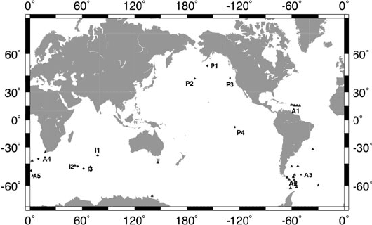
to us from various locations of the world ocean, are summarized in Fig. 1. Data
used in our analysis were obtained from the Proudman Oceanographic Laboratory,
the IFM-GEOMAR (MOVE – Meridional Overturning Variability Experiment) and
the Oregon State University. As can be seen from the figure, most of those time
series reside in the Southern Ocean or the Indian Ocean; only a few bottom pres-
sure data are available in the Pacific, and in the North Atlantic the only time s eries
available are located at about 15
◦
N in the western subtropical gyre.
For our analysis we use GRACE monthly solution from GeoForschungsZentrum
(GFZ), Potsdam and Center for Space Research (CSR), University of Texas. In
Fig. 1 Positions where bottom pressure measurements exist. Positions of bottom pressure
recorders, used for comparison with GRACE and GECCO monthly bottom pressure variability,
are marked by labels
300 D. Stammer et al.
general terms, GRACE measures the time-varying gravity field of the Earth once per
month (although higher temporal resolution seems possible). When using GRACE
level-2 data for investigations on ocean mass variability, two specific aspects
have to be considered, which are described in more detail by Siegismund et al.
(2010). First, ocean and atmospheric variability that was subtracted before pro-
cessing level-2 data to prevent aliasing into monthly variability, has to be restored.
Second, the maps have to be smoothed in a way that leakage of strong land sig-
nals is prevented as much as possible. Restoring of variability is done using the
GAD product that is provided together with the other GRACE products from
the GRACE processing centers. GAD contains non-tidal ocean and atmosphere
variability as provided by the ocean model OMCT and the ECMWF analysis
fields, respectively. Smoothing of the data is done using a sequence of filters.
As first step we use the Swenson and Wahr (2006) de-correlation filter. Still in
spectral domain a 200 km Gaussian filter is applied. After transformation to phys-
ical space, signals over land and over a 500 km wide stripe of ocean following
the coastline, is masked out. Finally a 600 km spatial Gaussian filter is applied.
With this approach we reduce land to ocean leakage substantially since smooth-
ing on large spatial scales is done on the physical maps rather than in the spectral
domain.
To test the consistency of model simulations with bottom pressure observations,
we use the output from different models and syntheses. They differ in the period
they simulate, in details of the numerics, but also in horizontal resolution. We used
four models here during the intercomparison:
(1) 1
o
GECCO first guess and synthesis (1952–2001, Köhl and Stammer, 2008a, b)
(2) 1
o
ECCO-GODAE synthesis (1992–2004, Wunsch and Heimbach, 2006)
(3) 1
o
GECCO-2 first guess and synthesis (2002–2007, Köhl et al., 2009)
(4) 2
o
OMCT (2001–2008, Thomas, 2002).
The ECCO-GODAE and GECCO synthesis products are nearly identical in their
methodology, numerical model, and the assimilated data, but cover different peri-
ods. In particular, GECCO does not overlap with GRACE. In contrast, GECCO-2
features a truly global extent, higher horizontal and vertical resolution, an ice model
and the inclusion of the Arctic Ocean. In all cases, the assimilation method builds
on the adjoint method, which was first implemented with the ECCO/MITgcm by
Stammer et al. (2002, 2003). The subsequent products were built on this ECCO
modeling and assimilation framework but assimilated additional data. The standard
types of data now include hydrographic data from TOGA/TAO, XBT/MBT, CTD,
and Argo profiles, satellite altimeter, and SST data. The assimilation procedure esti-
mates surface boundary conditions for heat, freshwater and momentum. The prior
for this forcing that was also used in first guess is based on the NCEP reanalysis.
OMCT (Ocean Model for Circulation and Tides) is the model being used during
the GRACE data processing and forced with ECMWF analysis data. This particular
version does not include lunisolar tidal dynamics but additional to the other products
atmospheric pressure forcing.