Gibilisco S. Meteorology Demystified
Подождите немного. Документ загружается.

longed rain. In this situation, foul weather can plague a region for days. This is
a stationary front.
All types of frontal systems—warm, cold, occluded, and stationary—can
cause severe weather. Cold fronts, however, are responsible for most heavy
thunderstorms and squall lines, and produce the most violent wind storms.
AIR MASSES AT WAR
In stable air, the temperature decreases at a fairly uniform rate as altitude
increases. This holds true for several kilometers upward. Frontal systems upset
the uniformity, and this is partly responsible for the formation of rain clouds.
In the vicinity of a frontal system, the temperature drops at first with increasing
altitude, but when the boundary between air masses is reached, the temperature
abruptly increases. As the altitude increases further, the normal pattern resumes.
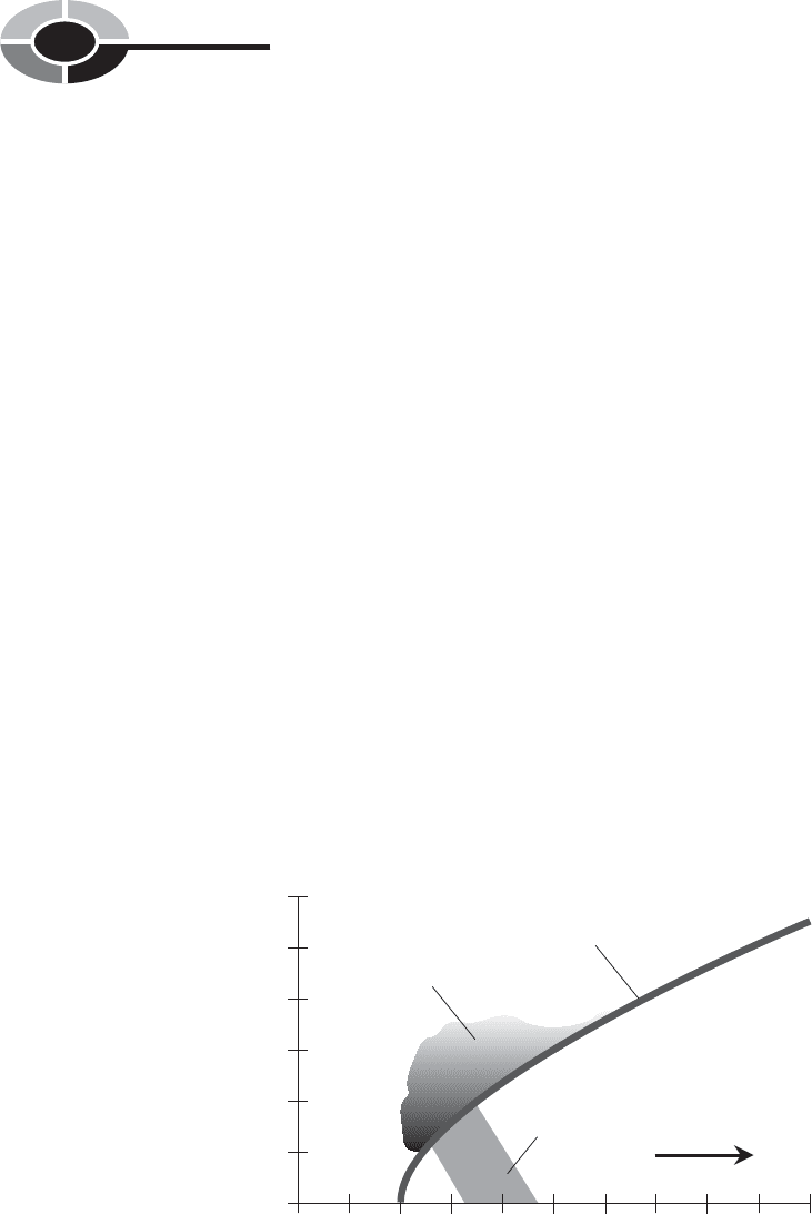
Fig. 4-2 is a vertical-slice diagram of a warm front. The thermal boundary is
shown by the heavy curve. The warm air, because it is lighter than the cold air,
tends to rise. As the front advances, the warm air flows over the top of the cold
air mass, resulting in a thermal inversion at an altitude that depends on the hor-
izontal distance from the front itself (the point at which the boundary between
the air masses meets the surface).
CHAPTER 4 Rain and Lightning
108
0
100
200 300
400 500
0
2
4
6
8
10
12
Horizontal distance, kilometers
Altitude, kilometers
Thermal
boundary
Clouds
Rainfall
Motion of front
Warm air mass
Cold
air
mass
Fig. 4-2. Vertical-slice diagram of a warm front associated with temperate-zone low-pressure
systems of spring and summer. The vertical scale is exaggerated.
The inversion in advance of a warm front can sometimes extend for hundreds
of kilometers. Because a warm front usually moves at a sluggish pace—a few
kilometers per hour—the cloudiness and rain can last for two or three days in
some places. Warm fronts in the spring and summer sometimes produce severe
weather, but usually they cause only moderate showers and thundershowers.
A cold front is more likely to give rise to severe thunderstorms. Figure 4-3 is
a vertical-slice diagram of a cold front. Because cold air is more dense than
warm air, the cold air mass pushes underneath the warm air mass. The leading
edge of the front is well defined, and it advances rapidly along the surface. The
temperature difference can be more than 10º C (18º F) at ground level at points
separated by only a few kilometers.
If a cold front encounters irregular terrain, or if the front is moving fast, the
leading edge of the cold air mass may “tumble over itself.” This is because the
air moves a little faster at an altitude of a few thousand meters than it does at the
surface. If this happens, warm air pockets are trapped under the leading part of
the cold air mass, creating powerful updrafts and turbulence as the warm air
rises. Such conditions can produce large hail.
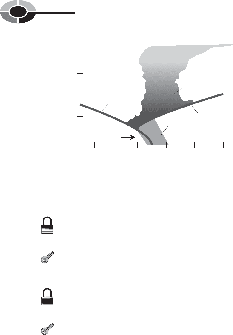
If an occluded front (Fig. 4-4) develops in a low-pressure system, severe
weather can occur in the vicinity of the occlusion. The advancing cold air mass
behind the front has a lower temperature than the air ahead of it, but the differ-
ence is not as large as it is when a cold front pushes rapidly into a mass of warm,
moist air.
CHAPTER 4 Rain and Lightning
109
0
100
200 300
400 500
0
2
4
6
8
10
12
Horizontal distance, kilometers
Altitude, kilometers
Thermal
boundary
Clouds
Rainfall
Motion of front
Cold
air
mass
Warm air
mass
Fig. 4-3. Vertical-slice diagram of a cold front associated with temperate-zone low-pressure
systems of spring and summer. The vertical scale is exaggerated.
PROBLEM 4-1
What happens to a low-pressure system after an occlusion has
occurred?
SOLUTION 4-1
A new warm front and cold front can form, as the winds around the
center continue to pull warm air from the tropics and cold air from
the poleward side of the system.
PROBLEM 4-2
What happens to the fronts in a low-pressure system as it moves away
from land and over the ocean?
SOLUTION 4-2
Warm, cold, and occluded fronts can still form, and can still exist, in
low-pressure systems over the ocean. The temperature difference
between the warm and cold air masses in an oceanic low-pressure sys-
tem is usually smaller than the temperature difference between the
warm and cold air masses in a low-pressure system over land.
CHAPTER 4 Rain and Lightning
110
0
100
200 300
400 500
0
2
4
6
8
10
12
Horizontal distance, kilometers
Altitude, kilometers
Thermal
boundary
Thermal
boundary
Clouds
Rainfall
Motion of front
Warm air mass
Warm air
mass
Cool air mass
Cold
air mass
Fig. 4-4. Vertical-slice diagram of an occluded front associated with temperate-zone
low-pressure systems of spring and summer. The vertical scale is exaggerated.

A Hypothetical Severe Thunderstorm
Tropical air, streaming up from the Gulf of Mexico and the southeastern states
in the spring and summer, presents the ideal scenario for severe thunderstorm
development, in conjunction with a fast-moving, intense cold front.
THE WATCH
When a severe thunderstorm watch is issued, it means that conditions are favor-
able for the development of such storms. Severe thunderstorm watches and tor-
nado watches are often given together, because severe thunderstorms are more
likely than less intense showers or thundershowers to spawn tornadoes.
Geographically, severe weather watch areas are nearly always shaped like
rectangles or parallelograms. Heavy thunderstorms tend to develop along the
most intense parts of a cold front. It is common for two or more widely sepa-
rated regions to receive severe thunderstorm watches at about the same time,
especially if there are two or more low-pressure systems over a continent, or if
a system contains an unusually long cold front.
Here is a hypothetical severe thunderstorm watch announcement: “Severe
thunderstorms, possibly containing large hail and damaging winds, are likely
until 9:00
P.M. Central Daylight Time (CDT). The greatest risk of severe
thunderstorms and tornadoes is along, and 80 km (50 mi) to either side of, a
line from 40 km (25 mi) north of Sioux Falls, South Dakota, to 80 km (50 mi)
southwest of Hayward, Wisconsin.” This defines the boundaries of the watch
parallelogram.
Most people living within the watch area will not experience a severe thun-
derstorm. Some will have a mostly sunny day and a pleasant evening. It’s even
possible that no severe storms will occur at all. The following day will be cooler
throughout the region, after the passage of the cold front.
THE WARNING
Suppose, in the above described scenario, that we live in Minneapolis. We there-
fore are within the watch area. The first reports of severe weather come from the
western and southern portions of the watch zone at 4:00
P.M. CDT. Worthington,
Minnesota, gets 5 cm (2 in) of rain in 30 minutes, along with marble-sized hail
and wind gusts to 55 kt (63 mi/h). The storm quickly passes.
CHAPTER 4 Rain and Lightning
111

In Minneapolis, there is no immediate cause for concern. The storm at
Worthington, although heavy, is far from life threatening for those who stay
indoors, away from windows (which can be broken by high winds or wind-
driven hail) and electrical appliances, bathtubs, shower stalls, swimming pools,
and antenna installations (which are hazardous because of lightning).
At 5:00
P.M., we hear the announcement that Minneapolis and its suburbs are
under a severe thunderstorm warning. “A line of heavy thunderstorms has been
sighted. Movement is toward the east–northeast at 26 kt (30 mi/h).” A group of
thunderstorms, called a multicell storm, is approaching. The warning is effective
until 6:30
P.M. for Hennepin County. A similar warning for Ramsey County will
soon follow. Severe thunderstorm warnings are typically issued for much
smaller areas than that of the associated watch. It is possible that severe thun-
derstorm warnings may have to be issued for localities not within the original
watch rectangle.
SEVERE OR NOT?
Thunderstorms frequently develop as isolated cells, in which case they are called
single-cell storms. Groups of two or three thunderstorms compose multicell
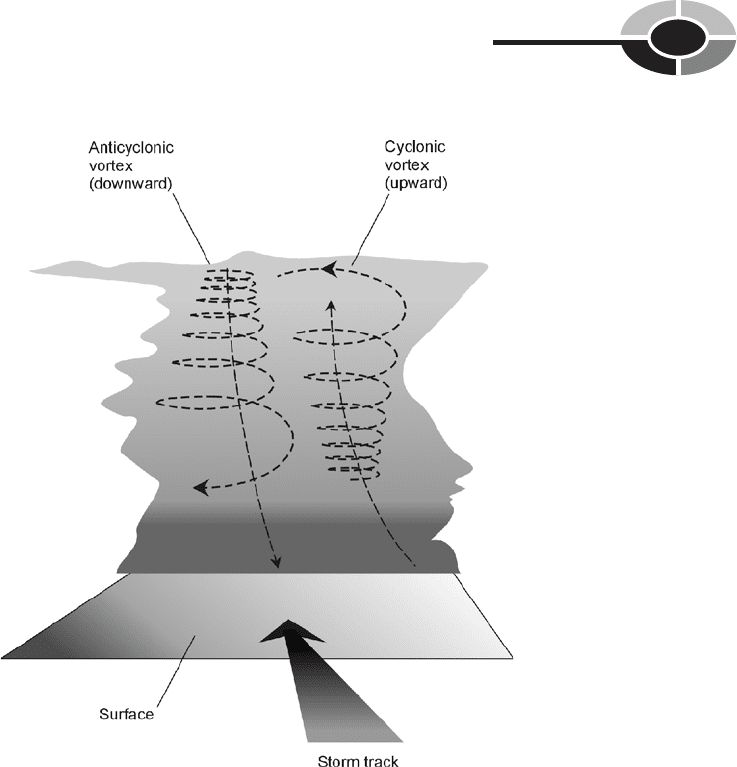
storms; this is the type of system now bearing down on us. The heaviest thun-
derstorms develop internal vortices. Deep within the main cloud, a clockwise, or
anticyclonic, vortex can form in the lefthand portion of the storm, and a coun-
terclockwise, or cyclonic, vortex can form in the righthand half (as the cell is
viewed from the rear). In the center of the thunderstorm, updrafts occur. These
updrafts can reach speeds of 150 kt (170 mi/h). The double-vortex structure
is illustrated in Fig. 4-5. This type of thunderstorm is called a supercell. The
cyclonic vortex is called a mesocyclone.
The internal circulation of a severe thunderstorm is revealed by means of
dual-Doppler radar. This instrument shows the locations of rain masses within
showers and thunderstorms, and also indicates the velocities (speeds and direc-
tions) of water droplets, thereby showing the internal wind circulation. With the
aid of computer graphics and animation programs, severe thunderstorms, moni-
tored by dual-Doppler radar, can be vividly portrayed in three dimensions. When
a thunderstorm has developed as a supercell structure, severe weather is likely,
and tornadoes are a particular danger.
Sometimes a supercell will split into two separate thunderstorms after it has
traveled some distance. The clockwise spinning vortex tends to turn toward the
left as the thunderstorm moves forward, and the counterclockwise vortex veers
toward the right. After the two vortices have separated sufficiently, the supercell
divides. If the process is repeated several times over a period of hours, a single
CHAPTER 4 Rain and Lightning
112
storm can become a multicell complex, and a group of thunderstorms can
become a squall line.
A typical thundershower lasts for a few hours. Supercells last longer, up to half
a day. The multicell and squall-line types of severe thunderstorms can persist for
even longer, and are more likely than the single-cell storm to become severe.
Showers and thunderstorms form more often during the afternoon and
evening hours than at other times of day. This can be explained by the fact that
the most thermal energy (heat) is present during the afternoon and evening. The
sun heats up the ground, and the warm earth imparts heat to the lower atmos-
phere, intensifying the contrast between the air temperatures on either side of a
moving cold front.
CHAPTER 4 Rain and Lightning
113
Fig. 4-5. The internal air flow of a typical supercell. Two vortices can form, one anticyclonic
and the other cyclonic. Updrafts sometimes blow at 150 kt (170 mi/hr).
In our hypothetical Minneapolis scenario, all of the factors for the formation
of a severe storm are present, including a hot, sunny afternoon with plenty of
ground heating. By 5:30
P.M., the sun is obscured by the tops of the cumulonim-
bus cloud bank, which has topped out at more than 14 km (46,000 ft). Reports of
hail and high winds begin to arrive at the office of the National Weather Service
from residents of the outlying southwestern and western suburbs.
PROBLEM 4-3
In which part of a severe thunderstorm is a tornado most likely
to form?
SOLUTION 4-3
Tornadoes are most likely to develop in the cyclonic portion of a super-
cell. This tends to be the right-rear part of the storm. This is why tor-
nadoes so often appear to follow along to one side of a supercell thun-
derstorm, and can strike when it is not raining and the weather seems
to have calmed.
Effects of a Thunderstorm
The specific events in an intense thunderstorm—heavy rain, hail, damaging
winds, and tornadoes—take place in different parts of a single cell. In multicell
storms or squall lines, the chance of any particular place getting hit by multiple
effects are greater than is the case with a single storm.
HEAVY RAIN
The heaviest rains tend to occur beneath the anticyclonic vortex in a heavy thun-
derstorm. The vortex develops a downdraft, which blows the rain down toward
the ground. The result can be a blinding torrent, reducing visibility to near zero
and producing spectacular amounts of rain in short periods of time.
HAIL
In a mesocyclone, powerful updrafts carry water droplets to great altitude. The
cold high-level air causes the raindrops to freeze. The ice pellets fall back as they
are scattered out of the updraft zone by high-altitude winds. Some of the ice
CHAPTER 4 Rain and Lightning
114

pellets melt in the warmer, low-level air and fall to the ground as rain. Others are
pulled back into the central updraft before they get a chance to melt. Water
droplets condense on these pellets, and then freeze to enlarge the pellets’ size as
they are tossed upward again to high altitudes. A single pellet can be carried up
and down repeatedly until it grows to such a size that, once it finally does defeat
the updrafts and get to the ground, it arrives still frozen, as a hail stone.
Most of the hail in a severe thunderstorm falls near the center of the cell. The
size of the hail stones depends on the strength of the updrafts in the storm;
the more powerful the air currents, the more times a hail stone can be carried
upward to acquire a new coating of ice. Hail stones are usually the size of peas
or small cherries. Occasionally, golf ball-sized hail forms. In rare instances, hail
stones become as large as baseballs or even grapefruit. Such large chunks of ice,
falling from an altitude of several kilometers, can ruin farm crops, injure or kill
livestock, and cause serious damage to property, particularly shingled roofs.
The amount of hail that falls, and the size of the stones, varies greatly within
a single storm. Baseball-sized hail might fall in one part of a town, while little
or no hail is reported in other places. Hail can sometimes accumulate to a depth
of several centimeters, and if high winds are present, drifting can occur.
Hail storms in the northern hemisphere are most frequently observed during
the months of April through September, with a peak around June and July. When
hail falls in the late fall or winter, the stones are usually so small that it is diffi-
cult to say whether the precipitation is hail or sleet.
WIND
Damaging straight-line (nontornadic) winds in a severe thunderstorm can
occur for various reasons. A powerful straight-line thunderstorm wind is called
a derecho (pronounced da-ray-cho).
The heavy rain in the lefthand part of a storm and the accompanying down-
draft from the anticyclone produce a rush of cool air ahead of the storm. Anyone
who lives in the Great Plains of the United States has observed this; it occurs
even in ordinary showers. This is known as a gust front, and the wind can rise
from near calm to 50 kt (58 mi/h) or more within seconds. As the rain begins,
the wind speed usually decreases.
Within a severe storm, high winds can result from the two vortices. These
winds have been known to gust to more than 100 kt (115 mi/h) at the surface in
massive supercells. Near the lefthand periphery of a supercell, the clockwise
twisting of the air acts in conjunction with the downdraft and the forward move-
ment of the cell to produce strong, straight-line surface winds.
CHAPTER 4 Rain and Lightning
115

Another cause of high straight-line winds, the least understood but potentially
the most destructive, is known as a microburst. It results from a small column of
air forced violently down toward the surface, and can produce straight-line winds
of such force that cars are flipped over, whole groves of trees blown down, and
roofs removed from buildings. In July 1977, a storm in and around Sawyer
county, Wisconsin, caused microbursts with localized gusts of well over 100 kt
(115 mi/h).
As we watch our hypothetical thunderstorm approach Minneapolis, the calm,
sultry air is suddenly disturbed by a cool, westerly breeze. The breeze rapidly
increases to a gale, and loose papers and other light objects are picked up and
carried along. Dust, blown aloft, gives the sky a menacing hue.
LIGHTNING
The most dangerous aspect of a thunderstorm, from the standpoint of risk to
human life, is lightning. It can occur anywhere within a thunderstorm, but is
most common around the periphery of the cloud base. The amount of lightning
in a thunderstorm is correlated with the severity. We will examine lightning in
detail later in this chapter.
TORNADOES
Tornadoes rank just behind lightning in terms of deadly effects. They almost
always occur in the cyclonic part of a supercell. Rarely, they form in the anti-
cyclonic portion. In Chapter 5, we will see how and why tornadoes form, what
they can do, and what we can do to protect ourselves and our property from them.
A SUPERCELL STRIKES
As we reach shelter, the rising wind slams the door back against the siding. It is
not easy to pull a door—even a light screen door—shut against this gale. But
finally it is latched, and we push the solid inner door closed behind it. It’s a good
thing we’re inside. A large tree limb comes tumbling down into the yard. Foliage
begins to litter the streets. The rain comes: a sprinkle at first, then sideways-
moving sheets. It pounds with fury against the north and west windows of the
house. As we hurry down the steps to the cellar, the electricity fails. For 30
minutes the winds rage. A portable radio tells us of widespread wind damage.
CHAPTER 4 Rain and Lightning
116

In the extreme southern suburbs, a tornado has been sighted, but it has not
touched down. Close to downtown, tennis-ball-sized hail has been reported by
unofficial observers.
The sounds of the wind and rain subside, and we return from the cellar to sur-
vey the damage. Many trees have been uprooted or snapped at the trunk. The tar
paper from our garage roof is lying in the middle of the street.
The meteorologist at the airport is on the radio. He says that they have
clocked winds of 75 kt (about 86 mi/h). The areas nearer downtown, including
our neighborhood, have received a more severe blow. In some neighborhoods,
hail stones have completely covered the grass, streets, and sidewalks. The tor-
nado stayed above the surface, and no damage is reported from it. Power out-
ages are widespread. Live wires dangle in puddles and hang, sparking, from
utility poles.
STAYING SAFE
When a severe thunderstorm watch is issued for your area, tune the radio to a
station that you like, and keep it playing in the background, continuously if pos-
sible. If you cannot listen continuously, then monitor the news broadcasts, usu-
ally given on the hour and sometimes also on the half hour. If time permits, get
your car or other motor vehicle to a sheltered place to protect it against damage
from hail or flying debris. Pick up loose yard tools, garbage cans, and other
objects that could be thrown by high winds. If you have a boat on a trailer, put
it in a sheltered place if possible. Otherwise tie it down with aircraft cable.
(This is a good routine practice, anyway.) Stay at home unless you absolutely
must travel.
The “little old ladies” who run around unplugging appliances before a storm
are not stupid! Lightning can ruin electrical appliances and electronic devices if
it strikes the power lines nearby. If you have any kind of radio or television appa-
ratus that is connected to an outdoor antenna, disconnect the antenna feed line at
the equipment before lightning starts to occur in your area. (If the storm has
already begun, it’s too late. In that case, stay away from the appliances!)
A severe thunderstorm can strike with amazing rapidity. The wind can rise
from calm to gale force within seconds. If you have a basement, go there (unless
it is prone to fill with water). Stay in the corner away from the wind, or in the
center, or in a room without windows. Glass can break from the force of the
wind or because of flying debris. Also stay away from electrical appliances, and
avoid any kind of radio, television, or hard-wired telephone equipment. Stay out
of elevators!
CHAPTER 4 Rain and Lightning
117