Gibilisco S. Meteorology Demystified
Подождите немного. Документ загружается.


If you hear this on the local weather forecast, they’ll read it as “eighty
hundredths of an inch.”
Advanced Observation Tools
Professional meteorologists use sophisticated systems to aid in their observation
of weather phenomena. The data and displays from these systems have become
available to lay people in recent years through Internet sites such as the Weather
Channel (www.weather.com).
RADAR
The term radar is an acronym derived from the words “radio detection and rang-
ing.” Electromagnetic (EM) waves, having frequencies in the ultra-high or
microwave range, reflect from certain types of objects and particles, including
aircraft, missiles, raindrops, ice pellets, and snowflakes. By ascertaining the
direction(s) from which radio signals are returned, and by measuring the time it
takes for an EM pulse to travel from the transmitter location to a target and back,
it is possible to locate flying objects and to evaluate some weather phenomena.
A complete radar set consists of a radio-frequency (RF) transmitter, a direc-
tional antenna, an RF receiver, and a display. The transmitter produces EM wave
pulses that are propagated in a narrow beam. The waves strike objects at various
distances. The greater the distance to the target, the longer the delay before the
reflected signal, or echo, is received. The transmitting antenna is rotated so that
the sky in all azimuth directions can be observed. Most radar sets are aimed at
the horizon, or a few degrees above it, so they can return echoes from the great-
est possible distances.
In original radar designs, there was a circular display consisting of a cathode-
ray tube (CRT). Nowadays, computers can take the signals from a radar receiver
and render them on a high-resolution liquid-crystal display (LCD) or plasma
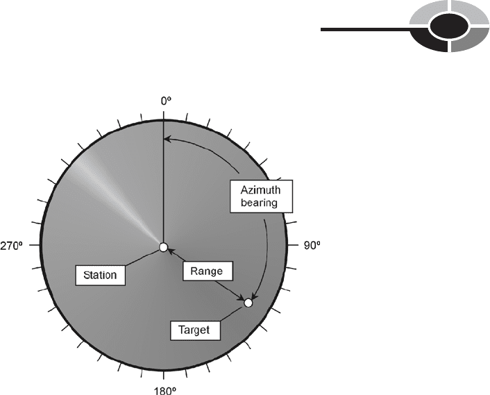
display. The basic display configuration is shown in Fig. 3-7. The observing sta-
tion is at the center of the display. Azimuth bearings are indicated in degrees
clockwise from true north, and are marked around the perimeter of the screen.
These show the compass direction of the echo relative to the station. The distance,
or range, of the echo is indicated by the radial displacement of the echo. The
radius on the display is directly proportional to the distance to the echo. Airborne
CHAPTER 3 Observation and Forecasting
88
long-range radar can detect echoes from several hundred kilometers away under
ideal conditions. A modest system with an antenna at low height can receive
echoes from up to about 80 km (50 mi) away.
Some radar sets can detect changes in the frequency of the returned pulses,
thereby allowing measurement of wind speeds in hurricanes and tornadoes. This
is called Doppler radar. This type of radar is also employed to measure the
speeds of approaching or receding targets. Doppler radar has proven invaluable
in detecting the presence of rotation within thunderstorms. This can provide
advance warning of tornado development.
LIGHTNING STROKE DETECTION AND LOCATION
All lightning strokes produce bursts, or pulses, of EM energy. You can hear these
as “static” on a portable radio tuned to the amplitude-modulation (AM) broad-
cast band. One method that can be used to locate a lightning stroke involves
measuring the time it takes for the EM pulse from a given stroke to arrive at two
or more receiving stations. This is a process familiar to navigators, and is known
as triangulation.
CHAPTER 3 Observation and Forecasting
89
Fig. 3-7. A radar display. The light radial band shows the azimuth direction in which the RF
beam is currently transmitted and received. (Not all radar displays show this band.)

Lightning strokes, when plotted on a regional map for a specific period of
time (such as within the last few hours), are usually concentrated in and near
areas of heavy precipitation. But this is not always the case. Some summer light-
ning in the United States desert Southwest occurs in the absence of precipitation.
The rain in this region often evaporates before it reaches the surface, even in
fairly strong thundershowers, because the air is dry and warm. Rain that does not
reach the surface is called virga.
Lightning stroke locators are useful for people planning outdoor activities.
They can also be useful to firefighting personnel in forested regions, because
lightning is often the culprit in destructive forest fires.
INSTRUMENTS SENT ALOFT
A radiosonde is a portable, battery-powered weather station that is carried aloft
by a helium balloon. It contains a thermometer, a hygrometer, a barometer, and
a radio transmitter. The transmitter sends encoded data to stations on the ground.
The position of the device in three-dimensional space at any given moment can
be pinpointed using triangulation from multiple surface-based stations. In this
way, the temperature, relative humidity, and barometric pressure are determined
as functions of altitude, and also as functions of the point on the surface directly
below the radiosonde (the exact geographical location). The wind direction and
speed at various altitudes can be determined by observing and recording the
direction and speed of the point on the surface directly below the device. The
radiosonde can operate in the troposphere and lower stratosphere—as high as a
balloon can take it.
A dropsonde is an instrument and radio transmitter similar to a radiosonde.
The difference is that the dropsonde is released from a high-flying aircraft rather
than sent up from the surface. It has a parachute instead of a balloon. A drop-
sonde is especially well suited to use in hurricanes and large thunderstorms. It
can monitor conditions, and record wind speeds and the intensity of updrafts and
downdrafts, at points within such storms that are too dangerous for aircraft.
Other vehicles for carrying instruments into the atmosphere include manned
aircraft, helicopters, and rockets. Rockets can attain higher altitudes than other
vehicles, so they can send back data at all levels of the atmosphere, not only
the troposphere and lower stratosphere. The hurricane hunter aircraft is flown
directly into the eyes of hurricanes, recording and observing conditions along
the way. This aircraft is piloted by people who not only obtain quantitative data,
but who directly observe (and vividly recall) qualitative conditions. In this
respect, the difference between a radiosonde or dropsonde and a hurricane
CHAPTER 3 Observation and Forecasting
90

hunter is like the difference between the Mars lander and a manned mission to
the planet.
WEATHER SATELLITES
The first weather satellite that provided pictures of the earth and cloud forma-
tions in the troposphere was called TIROS. It was launched in April, 1960. The
TIROS satellite was approximately 0.6 m (2 ft) high and 1.2 m (4 ft) wide, and
shaped like a can of tuna. Since this satellite was deployed, many others have
been put into various types of orbits so that meteorologists can keep constant
watch on the weather everywhere in the world.
The first weather satellites were in low orbits, at altitudes of only 200 km
(125 mi) or so, and took approximately 90 minutes to complete a single revolu-
tion around the earth. Today, most weather satellites orbit at much higher alti-
tudes, and they take longer to orbit the earth. When a satellite is put into orbit at
a distance of approximately 36,000 km (22,500 mi) above the surface, the orbital
period is 24 hours. This is called a geosynchronous orbit. Satellites in geosyn-
chronous orbits above the equator are known as geostationary satellites, because
they are always above the same point on the surface. In order to be geostation-
ary, a satellite must orbit directly above the equator, and must remain at exactly
the correct altitude all the time. It must also be revolving around the earth in the
same direction that the earth rotates (counterclockwise as viewed from high
above the north pole).
The first TIROS satellites orbited the earth at an angle of 48° relative to the
equator. To observe a certain part of the world, it was necessary to wait until the
satellite came within a few hundred kilometers of that location. Places at lati-
tudes north of 55°N, or south of 55°S, couldn’t be observed. Later, as rocket
technology improved, satellites were placed in orbits tilted at angles of nearly
90° relative to the equator. Such an orbit is called a polar orbit. As the earth
rotates beneath a polar-orbiting satellite, different parts of the world come into
view. Over the course of half a day, a composite picture of the whole planet can
be obtained. Such a combination of small photographs, put together to show a
large area, is called a mosaic.
Today’s fleet of weather satellites can view nearly an entire hemisphere of the
earth at once, or zoom in on a particular weather system or surface feature. There
are cameras sensitive to various wavelengths, including visible light, infrared
(IR), and water-vapor (WV) emission spectra. The cameras can be adjusted to
obtain more or less magnification. As the magnification increases and all other
factors are held constant, the image resolution (detail) increases.
CHAPTER 3 Observation and Forecasting
91

REMOTE MONITORS
Geostationary weather satellites are equipped with radio receivers and transmit-
ters. Weather information is collected from remote monitoring stations on the
surface. These include rain gauges, tide gauges, ships, manned weather stations,
and automatically controlled weather stations.
A single satellite can be used to compile all the data from thousands of dif-
ferent surface-based stations, both manned and unmanned, at frequent intervals.
The satellite can get the information from a particular station by sending a com-
mand to the station. Some stations send information to the satellite whenever
unusual or severe weather conditions or other natural events occur.
LINEAR INTERPOLATION
Weather data is collected at defined, usually fixed, locations on the surface. The
number of locations may be large, but it is not infinite. Therefore, conditions at
points not located at observing stations must be estimated. A common way to
estimate intermediate data is by linear interpolation.
Suppose it is a warm spring day in Minnesota, and the temperature at the
weather station in Minneapolis is 21°C. In Rochester, approximately 100 km to
the southeast, the temperature is 19°C. The temperature in Cannon Falls, located
50 km southeast of Minneapolis and 50 km northwest of Rochester, can be
estimated by interpolation as the average of the temperatures at Minneapolis
and Rochester, or 20°C. This is because Cannon Falls lies near the midpoint
of a straight line connecting the two weather stations from which data has
been obtained.
Interpolation does not always work. In regions where the terrain is irregular,
elevation affects the temperature. In some locations, small-scale weather phe-
nomena can be dramatic. Interpolation is not a reliable way to estimate data in
these kinds of situations. In the Black Hills of South Dakota, for example, par-
ticularly in the winter, a few hundred meters difference in elevation can produce
amazing differences in temperature. This is especially true when an inversion
occurs, and warm air overlies cold air. Two stations, at the same elevation and
separated by 10 km, might report temperatures of 5°C, while another station,
midway between them but 200 m lower in elevation, reports −10°C.
Suppose, on that warm Minnesota day, an intense cold front moves through the
state from the northwest towards the southeast. As the front passes Minneapolis,
the temperature drops to 12°C. In Rochester, the afternoon sun has warmed things
up to 21°C; the front has not yet arrived there. Interpolation is not a good way
to estimate the temperature in Cannon Falls in this scenario. If the front has not
CHAPTER 3 Observation and Forecasting
92
yet arrived in Cannon Falls, the temperature there might be 20°C. An hour later,
it might be 13°C, even if the temperatures in Minneapolis and Rochester have
not changed during that hour.
The use of linear interpolation is not confined to temperatures. It can be used
for any variable, including relative humidity, wind speed, wind direction, baro-
metric pressure, and percentage of cloud cover. When using linear interpolation,
it is important to keep in mind the limitations imposed by localized weather
anomalies, irregular terrain, proximity to water, and other variables. Also, it’s
worth noting that linear interpolation is useful only between points that are fairly
close together (a few tens of kilometers or less). Thus, you can’t interpolate the
conditions in St. Louis, Missouri, based on known conditions in Miami, Florida
and Seattle, Washington.
PROBLEM 3-4
Imagine a situation in which linear interpolation is reliable, such as an
open prairie without weather fronts in the vicinity. Suppose the tem-
perature in Happyton is 20.0°C and the temperature in Blissburg,
70 km away, is 22.0°C. Now consider Joyville, which does not lie on a
straight line connecting Happyton and Blissburg, but is 70 km away
from Happyton and 30 km away from Blissburg. Using linear interpo-
lation, give an estimate of the temperature in Joyville.
SOLUTION 3-4
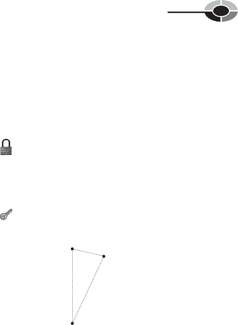
Refer to Fig. 3-8. Suppose you take a straight-line trip from Happyton
to Joyville. This is 70 km. Then imagine traveling in a straight line
CHAPTER 3 Observation and Forecasting
93
Happyton:
20.0°C
30 km
70 km
70 km
Joyville:
20.0 + (0.7 × 2.0)
= 21.4°C
Blissburg:
22°C
Fig. 3-8. Illustration for Problem 3-4.

from Joyville to Blissburg. This is 30 km. The total distance traveled is
70 km + 30 km, or 100 km. The temperature difference at the extreme
points, representing the beginning and end of your complete trip, is
2.0°C. In terms of your route, Joyville is 70/100, or 0.7, of the way
from Happyton to Blissburg. Thus, the temperature in Joyville can be
estimated as 20.0 + (0.7 × 2.0) = 21.4°C.
WHAT DOES “LINEAR” MEAN?
In the foregoing scenario, the estimation process for the temperature at Joyville
represents linear interpolation in the mathematical sense. But it is an imperfect
application of the process, because the three towns don’t lie on a geographical
straight line. Linear interpolation works best when the location for which condi-
tions are to be estimated lies on a geographical straight line between the two
observation stations. If the evaluated location is not on this straight line, linear
interpolation is less reliable. The greater the deviation from a straight line, the
greater the chance for error in the result obtained by linear interpolation.
Forecasting Methods
The science of weather prediction has improved over the past several decades,
largely as a result of the use of increasingly powerful computers and sophisti-
cated observing equipment. Nevertheless, some basic principles, along with his-
torical data, will always be useful.
HISTORY REPEATS—SOMETIMES
One of the simplest forecasting techniques involves examination of past weather
events that followed conditions similar to those observed. For example, if you
live in the American Midwest, you know that a warm, cloudy spring day with a
southerly breeze, high humidity, and a rapidly falling barometer reading is more
likely to produce a tornado than a cool, clear, dry day in early autumn with a
high, steady barometer reading. If records are kept over a period of decades and
then the data is carefully examined, correlations will be found. Certain condi-
tions are followed by specific types of weather events—usually. But not always!
CHAPTER 3 Observation and Forecasting
94

Forecasting based on history can be surprisingly accurate. It can also be
astonishingly inaccurate! Have you ever seen a table that provides weather fore-
casts based on easily observed factors such as the barometric pressure and the
wind direction? Table 3-1 is an example that can be used by amateur meteorol-
ogists to obtain forecasts in the American Midwest and Northeast. But this table
does not work all the time. It won’t work as well in Miami, San Francisco, or
Honolulu as it will in Boston. It certainly won’t be of much use to someone liv-
ing in Sydney, Australia or in Santiago, Chile.
CHAPTER 3 Observation and Forecasting
95
Table 3-1. Some common weather signs and forecasts for locations in the American
Midwest and Northeast.
Barometer Barometer Wind
reading (inHg) movement direction Forecast
30.00 to 30.20 Steady SW to NW Fair for the next day or two.
30.00 to 30.20 Rising SW to NW Fair for a day or two; then rain
or snow possible.
30.20 or above Falling slowly SW to NW Fair for a day or two, with
warming trend.
30.00 to 30.20 Falling S to E Becoming cloudy; rain or snow
likely in a day or two.
30.00 to 30.20 Falling S to NE Rain or snow likely within
24 hours.
30.00 to 30.20 Falling E to N Rain or snow likely within
24 hours; rising wind.
30.00 or below Falling slowly SE to N Rain or snow for a day or two.
30.00 or below Falling rapidly SE to NE Rain or snow likely within
hours; high wind possible.
29.80 or below Falling rapidly S to E Heavy rain or snow likely within
hours; high wind possible.
29.80 or below Falling rapidly E to N Storm likely within hours;
blizzard possible in winter.
29.80 or below Rising rapidly Veering to Cooler, with rain or snow ending.
W or NW

“Historical forecasting”—predicting the weather by assuming that what hap-
pened in the past will happen again this time—is one of the methods used to pre-
dict the tracks of hurricanes. Suppose you live in Charleston, South Carolina,
and it is mid-September. You know that hurricanes can be a factor at this loca-
tion during this time of the year. Suppose a category 3 hurricane (let’s call it
Ellen) is churning along just north of the island of Hispaniola. You go to one of
the weather Web sites on the Internet and find a hurricane tracking map that
shows the paths of all category 3 September hurricanes in the past several
decades that have tracked within 320 km (200 mi) of Ellen at this point. You see
that the tracks are concentrated in a generally west–northwesterly direction
(approximately azimuth 290°) for some distance, and then they begin to diverge.
By looking at these tracks, you can get some idea of the risk Ellen poses to you.
PERSISTENCE FORECASTING
One of the simplest methods of forecasting the weather is to assume that it will
not change for a little while. This technique, called persistence forecasting, is
often reliable over periods of minutes or hours. If a blizzard is blowing where
you are right now, you can be pretty sure it will still be going 10 minutes from
now, or 30 minutes from now. If the current barometric pressure is 29.65 inHg,
you can be reasonably certain that it will be close to this value for the next few
hours, unless a hurricane is bearing down on you.
In most locations, persistence forecasting doesn’t work well for periods
longer than a couple of hours, because the temperature and cloud cover often
vary greatly between morning and afternoon, afternoon and evening, and of
course, between day and night. There are some places, too, where it is risky even
to attempt a forecast for the next half hour. Have you heard people say, “If you
don’t like the weather, wait a few minutes”? That can be literally true in loca-
tions such as the northern Black Hills in the summer, where the sun can be shin-
ing at one moment and marble-sized hail falling five minutes later. It is also true
just before and during the passage of a “Texas norther,” a rainband in a hurri-
cane, or a fast-moving thunderstorm.
TREND FORECASTING
A more reliable and versatile method of short-term forecasting involves the
assumption that a current tendency or trend will continue, or that an observed cycle
will repeat. This is known as trend forecasting. It is a form of extrapolation—
extending a defined rate of change into the future.
CHAPTER 3 Observation and Forecasting
96

Suppose that it is 11:00 A.M. in your town, and you have been observing the
temperature for the past several hours. At 8:00
A.M. it was 20°C. Then it rose to
22°C at 9:00
A.M., 24°C at 10:00 A.M., and 26°C at 11:00 A.M. A trend forecast
would suggest that at 12:00 noon, the temperature will be 28°C.
There are limitations to this method. You can’t keep extrapolating and con-
clude that within a couple of days, the air will be hot enough to boil water! In
fact, if a cold front is approaching or you live in the tropics where rain showers
are an almost daily occurrence during the afternoon hours, the trend will soon be
reversed. By 5:00
P.M. it might be only 20°C again, after the front has passed or
the shower has cooled things down.
Trend forecasting has been applied to long-term climate prediction. The con-
troversy over global warming—Is it really happening, or not?—has been largely
resolved by observing average temperature trends since about the year 1900.
Based on this data, you’ll hear scientists warn that if current trends continue, the
entire planet will be several degrees Celsius warmer, on the average, a century
from now, as compared with conditions today. They will also report trends in
other factors such as the frequency and intensity of hurricanes, the ocean tem-
perature, the distribution of rainfall, and changes in sea level.
STEERING
Have you heard that storm systems are “blown along” by upper-atmospheric
currents, especially the jet streams? To some extent this is true, but it is an over-
simplification. The jet streams, which you learned about in the last chapter, blow
west–to–east in the upper troposphere along narrow, riverlike channels of air.
There are two or three jet streams in the northern hemisphere, and counterparts
in the southern hemisphere. The most significant of these are the mid-latitude jet
streams. One of these meanders through the temperate zones between latitudes
of approximately 30°N and 60°N. The other behaves in a similar manner
between approximately 30°S and 60°S.
Low-pressure systems in the temperate zones tend to track along the jet streams,
centered slightly poleward of them. (Hurricanes in the tropics follow atmospheric
currents, too, but do not interact with the jet streams unless or until they enter
the temperate zones.) Blizzard tracks can be predicted by watching the behavior
of the jet streams. Individual fronts, and thunderstorm cells or snow squalls
within these large cyclonic systems, however, tend to form, dissipate, and rede-
velop in a different way. Rather than following the jet stream, these smaller com-
plexes are guided by the circulation around the main cyclonic system, or “low.”
On the Eastern Seaboard and Gulf Coasts of the United States, residents hear
the term steering currents in conjunction with hurricanes. These are not jet
CHAPTER 3 Observation and Forecasting
97