Gibilisco S. Meteorology Demystified
Подождите немного. Документ загружается.


point, extent and type of cloud cover, type of precipitation (if any), wind direc-
tion, wind speed, and barometric pressure. All of this information is fed into a
computer, and the computer transforms it into a detailed graphical representation
of the weather over the whole country. The conditions at each weather station
are indicated on the weather map by a set of symbols known as a station model.
ISOBARS
Equal-pressure lines, called isobars, are drawn on weather maps to represent
various pressure levels in units called millibars (mb). Isobars are typically drawn
representing pressures at intervals of 4 mb, equivalent to about 3 mm (0.12 in)
of mercury. If P
mb
is the pressure in millibars, P
mm
is the pressure in millime-
ters of mercury, and P
in
is the pressure in inches of mercury, then you can use
the following formulas to convert among them:
P
mb
= 1.333 P
mm
= 33.86 P
in
P
mm
= 0.750 P
mb
= 25.40 P
in
P
in
= 0.02953 P
mb
= 0.03937 P
mm
The isobars on a weather map show the locations of the cyclones and anticy-
clones. In the vicinity of high- and low-pressure systems, the isobars are curved.
If the system is intense, several closed isobars exist around the center. The wind
blows nearly parallel to the isobars, especially when the isobars are close
together. When isobars are close together, it shows that the pressure gradient is
steep. High winds tend to occur in regions indicated by closely spaced isobars
on the weather map.
SYMBOLS IN GENERAL
The temperature data on a weather map gives an indication of the locations of
fronts, where air masses having different characteristics come together. Most
severe weather occurs near fronts. The isobars are “kinked” along the line of an
intense or fast-moving front. Stormy weather tends to occur near these zones.
Weather fronts are plotted as lines with bumps or barbs that indicate the type of
front and the direction of movement.
There are four major types of fronts. In a cold front, a cold air mass pushes
its way into warmer air. In a warm front, a warm air mass pushes its way into
CHAPTER 2 The Atmosphere
58
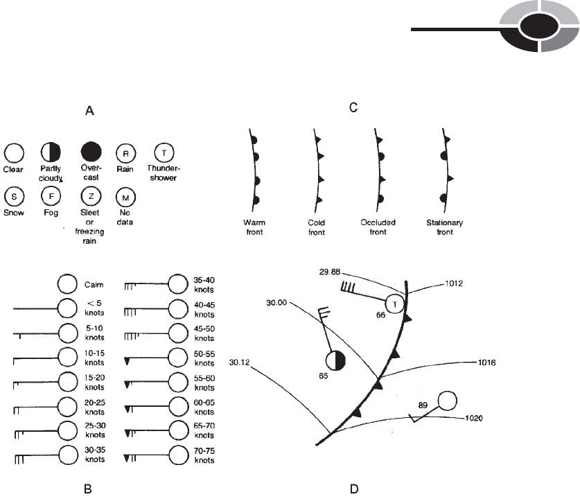
cooler air. In a stationary front, a warm air mass and a cold air mass meet in a
boundary that moves slowly or not at all. When a cold front catches up to a warm
front ahead of it, the result is called an occluded front.
The common weather map symbols are shown in Fig. 2-7, and a hypothetical
weather map, similar to the type you might see in a major daily newspaper, is
shown in Fig. 2-8. In the situation of Fig. 2-8, a strong midwinter low-pressure
system is sweeping across the central United States, and an intense cold front is
pushing eastward across Texas.
The weather maps used by meteorologists are more detailed than the one
shown in Fig. 2-8. Computer-generated maps show such things as lines of equal
temperature (isotherms) or weather conditions at various altitudes, but the simple
CHAPTER 2 The Atmosphere
59
Fig. 2-7. Sky condition symbols (A), wind speed symbols (B), frontal symbols (C), and a cold
front as it might appear on a local weather map (D).
map found in the daily newspaper is sufficient for you to get a good idea of what
is happening throughout the continent. You can tell with reasonable accuracy
where the major weather systems are. If you know the position of the jet stream,
you can forecast where the storms will pass.
PROBLEM 2-4
In the situation shown by Fig. 2-8, where would the strongest wide-
spread winds likely be found?
SOLUTION 2-4
The most intense winds are likely to occur where two things happen
simultaneously: (1) the isobars on the weather map are close together,
CHAPTER 2 The Atmosphere
60
Fig. 2-8. A simplified weather map, showing a hypothetical low-pressure system
over the central United States.
and (2) the wind direction is the same as the direction in which the
weather system giving rise to that wind is moving. In Fig. 2-8, this is
near, and to the south of, the center of the low-pressure system over the
middle part of the United States.
PROBLEM 2-5
In the situation shown by Fig. 2-8, where would the strongest localized
winds likely be found?
SOLUTION 2-5
This question is more difficult to answer than the previous one.
Localized winds are affected by mountains, canyons, the presence of
tall buildings, and storms associated with weather fronts. Cold fronts
are often associated with heavy thunderstorms, which can occur at any
time of year in the extreme southern United States. It is even possible
that there is a tornado somewhere near the cold front in the situation
shown by Fig. 2-8, in which case the highest localized winds would be
found there.
Wind Speed
Normally, the wind does not blow hard enough to have too much effect on
things. Occasionally, there is an exceptionally windy day or a brief rush of
strong wind as a thundershower approaches and passes. Once in a while, the
wind becomes strong enough to cause massive damage to natural and human-
made things.
UNITS OF SPEED
Wind speed can be specified in meters per second (m/s), kilometers per hour
(km/h), statute miles per hour (mi/h), or nautical miles per hour, also known as
knots (kt). The most common unit used by weather forecasters and other pro-
fessionals is the knot, which is equivalent to approximately 1.852 km/h or
1.151 mi/h. The most common unit used by news and weather broadcasters in
the United States is the statute mile per hour, which is equivalent to approxi-
mately 1.609 km/h or 0.8690 kt.
CHAPTER 2 The Atmosphere
61
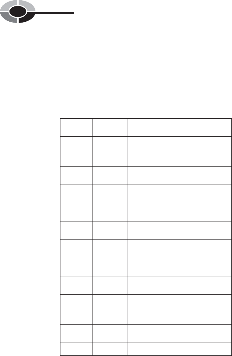
THE BEAUFORT SCALE
Early in the nineteenth century, an admiral in the British Navy, Sir Francis
Beaufort, noticed that winds of various speeds produced consistent and visible
effects on land and at sea. Not everyone has a wind-speed measurement instru-
CHAPTER 2 The Atmosphere
62
Beaufort Wind speed
number in knots General observed effects
0 0 Calm; smoke rises vertically.
1 1–3 Smoke shows direction of wind, but
weather vanes do not.
2 4–6 Wind can be felt on face. Leaves move
slightly.
3 7–10 Leaves are in continual motion. Small
flags unfurl.
4 11–16 Dust is raised. Papers blow around. Small
tree branches move.
5 17–21 Medium-sized tree branches move. Small
trees sway.
6 22–27 Large tree limbs are in constant motion.
Utility wires whistle.
7 28–33 Whole trees are in constant motion.
Umbrellas turn inside-out.
8 34–40 Gale. Twigs and leaves break off trees.
Walking into wind is difficult.
9 41–47 Strong gale. Branches break off trees.
10 48–55 Whole gale. Trees are heavily damaged.
Minor structural damage occurs.
11 56–63 Storm. Numerous trees blow down.
Considerable structural damage occurs.
12 64 or more Hurricane. Widespread destruction occurs.
Table 2-1. Beaufort scale for winds on land. Wind speeds are sustained (based
on a 1-minute average.)
ment (anemometer), but you can get a good idea of the wind speed by observ-
ing what it does to trees, dust, buildings, or the surface of a large body of water.
Table 2-1 shows the Beaufort scale for winds observed on land, and Table 2-2
shows the Beaufort scale for winds observed at sea or on large lakes. The num-
bers range from 0 (calm) to 12 (hurricane force).
CHAPTER 2 The Atmosphere
63
Table 2-2. Beaufort scale for winds over large bodies of water. Wind speeds
are sustained (based on a 1-minute average).
Beaufort Wind speed
number in knots General observed effects
0 0 Surface is glassy, but swells may exist.
1 1-3 Small ripples form.
2 4-6 Small waves form.
3 7-10 Moderate-sized waves form. Some waves
break.
4 11-16 Moderate-sized waves break consistently.
5 17-21 Moderate-sized and large waves occur,
and some airborne spray is observed.
6 22-27 Large waves occur with whitecaps and
airborne spray.
7 28-33 Large waves produce foam, and there is
considerable airborne spray.
8 34-40 Gale. Large waves occur with foam,
streaking on surface, and airborne spray.
9 41-47 Strong gale. High waves occur with dense
foam streaks. Air is dense with spray.
10 48-55 Whole gale. High waves occur with
dangerous crests. Visibility deteriorates.
11 56-63 Storm. Massive waves occur. Visibility is
reduced to near zero.
12 64 or more Hurricane. Air is filled with spray that
blows horizontally. Huge waves occur.
WIND FORCE
Perhaps you have wondered why a 40 kt wind does little or no damage, while an
80 kt wind, only twice as fast, can snap trees off at the trunk, shatter window
panes, and send large objects flying through the air. Moving air produces meas-
urable forces against objects that get in the way. This force increases much more
rapidly than the speed in knots. This is why incredible things happen in severe
hurricanes and in tornadoes. The power of the wind in a tornado can be thou-
sands of times the power of a late-autumn gale that rattles the windows and
strips the last of the leaves from the trees.
When a strong wind blows against a building, force is produced directly
against the wall or walls facing most nearly into the wind. This is positive
force. There are also other forces generated by winds blowing around an
object. As the air flows over the roof, the pressure above the surface goes
down, producing negative force as the air inside the building pushes upward.
If the wind gets strong enough, part or all of the roof can be ripped off
because of this force. Similar negative forces are produced on walls that face
sideways to the wind; windows are sometimes blown out by this pressure.
Some negative pressure also occurs on the wall or walls facing away from the
oncoming wind.
PROBLEM 2-6
Suppose you look at an Internet site for tropical weather and learn that
a hurricane has sustained winds of 120 kt. What is the equivalent wind
speed in miles per hour? In kilometers per hour?
SOLUTION 2-6
From the above discussion, we know that a wind speed of 1 kt is equal
to approximately 1.151 mi/h. Therefore, 120 kt = 138 mi/h. A speed of
1 kt is equal to approximately 1.852 km/h. Therefore, 120 kt = 222 km/h.
Clouds
Clouds normally form in parcels of air where the relative humidity is 100%, that
is, when the air is saturated with water vapor. The temperature at which clouds
form depends on how much water vapor is in the air. The more water vapor the
air contains, the higher the temperature at which clouds can form.
CHAPTER 2 The Atmosphere
64

CAUSES OF CLOUDS
The temperature of the air decreases steadily with increasing altitude, but the
amount of water vapor does not necessarily decrease with altitude. Thus, the
relative humidity typically rises with altitude. If it rises to 100% at a certain
level, clouds can form at and above that level, because condensation forms on
airborne dust particles. The development of clouds is accelerated by atmospheric
updrafts, when moist air ascends to great heights. The higher the relative humid-
ity, in general, the lower the altitude at which clouds begin to form. On a muggy
or rainy day, clouds are usually observed at low altitudes, and in the extreme
case, they form on the ground. Then they are called fog.
Meteorologists and aviators speak of the cloud ceiling (often simply called
the ceiling). This is the altitude of the bottom of the lowest layer of clouds, meas-
ured with respect to either sea level or the earth’s surface. Clouds form in a vari-
ety of shapes and patterns. Meteorologists have several different classifications
for tropospheric clouds. Clouds are named according to their relative altitude
and their general shape. Clouds associated with weather at the surface occur
at altitudes from sea level to the top of the troposphere. Nacreous clouds and
noctilucent clouds form above the troposphere, and are not directly associated
with weather at the surface.
HIGH-ALTITUDE CLOUDS
The highest tropospheric clouds range from altitudes of about 7 km (20,000 ft) to
18 km (60,000 ft) above sea level. They are named with words that begin with the
prefix cirr- from the Latin word cirrus, meaning “curly.” Wispy, web-like cirrus
clouds are commonly seen. High, smooth clouds are called cirrostratus. They give
the sky a milky appearance and frequently cause a ring around the sun or moon.
An old adage says that a ring around the sun or moon means rain or snow is
on the way. This is often true. Low-pressure systems are commonly preceded by
high, thin clouds such as cirrostratus. Some high clouds have a congealed or
puffy look. These are known as cirrocumulus. They can cause partial or com-
plete overcast.
MID-ALTITUDE CLOUDS
The mid-level clouds are between about 800 m (6000 ft) and 7 km (20,000 ft)
above sea level and are given the prefix alto-, which is Latin for “high.”
CHAPTER 2 The Atmosphere
65

Mid-level clouds sometimes have a flattened appearance, in which case they
are called altostratus. Altostratus clouds are lower and thicker than cirrostratus.
Mid-level clouds with a puffy look are known as altocumulus.
LOW-ALTITUDE CLOUDS
The lowest clouds have bases at altitudes less than 800 m (6,000 ft). These
clouds are sometimes given the prefix strat-. Low clouds sometimes extend all
the way to the surface, in which case fog occurs.
Low, flat clouds are called stratus clouds. If rain falls from them, they are
called nimbostratus. Low, rolling, gray stratocumulus are seen on an overcast
but dry day typical of much of the United States in late autumn. The cottonlike
puffs of fair-weather cumulus are easy to recognize.
CLOUDS AT MULTIPLE ALTITUDES
Several kinds of clouds can exist at the same time, at various altitudes. It is not
uncommon, especially in storm systems, to observe three different and distinct
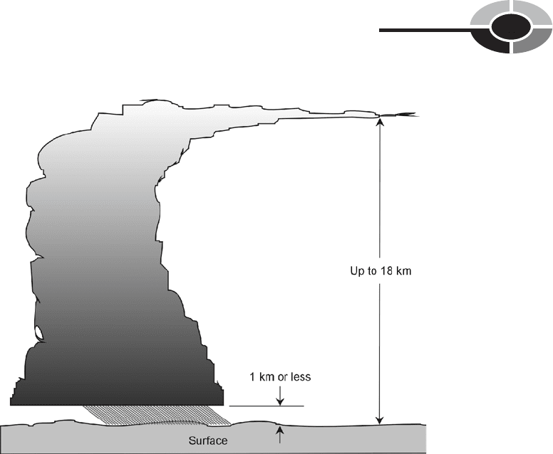
cloud layers. One well-known type of cloud complex, the cumulonimbus,
encompasses low, medium, and high levels, often extending from approximately
1 km (3300 ft) to the top of the troposphere (Fig. 2-9). These clouds sometimes
produce severe thunderstorms.
Cumulonimbus clouds sometimes stand alone in an otherwise clear sky. In
other storm systems, especially in front of strong cold fronts, multiple cumu-
lonimbus clouds merge into squall lines. Cumulonimbus clouds congregate in a
donut-shaped, revolving mass around the eye of a tropical storm or hurricane.
Imagine that it is a cloudy, dark day, and you board an airplane bound for a
distant place. You know the airplane will be flying at a high altitude. As you set-
tle in for the long ride, the pilot’s voice comes over the speakers. She tells you
that the cruising altitude will be 37,000 feet (approximately 11 km or 7 mi). The
plane climbs into a nimbostratus cloud bank. The clouds are so thick that you
can hardly see the wings. Then the aircraft bursts into the clear, only to reveal
another, higher cloud layer. You recognize it as altocumulus. Even at this alti-
tude, the sky is overcast. The plane climbs higher and enters the second deck of
clouds. You emerge from the second cloud deck into sunshine, but you can see
clouds in the distance at a still higher altitude. As you squint into the sun, you
discern a cumulonimbus “thunderhead” about 60 km (40 mi) away, and cirro-
stratus at about the same distance. The altocumulus clouds, through which you
CHAPTER 2 The Atmosphere
66
have just passed, recede underneath the aircraft, which is still gaining altitude.
This scenario is typical of midsummer over continents at temperate latitudes.
OTHER CLOUD TYPES
Clouds do not always fall neatly into common classifications. There might be
some doubt, for example, whether a certain cloud is cumulus or altocumulus.
Not all clouds of a given type look exactly the same. The wind speed at the cloud
level, the angle from which the sun or moon is shining, the extent of cloud cover
at higher or lower altitudes, and other factors affect the appearance of clouds.
Some clouds are unusual or interesting enough to have special names. For
example, when cumulus clouds build up in the heat of the summer, towering
higher and becoming wider at the base, they are called cumulus congestus. The
“thunderheads” nearly merge together. When rain begins to fall from such
clouds, they technically become cumulonimbus.
CHAPTER 2 The Atmosphere
67
Fig. 2-9. Cumulonimbus clouds affect the troposphere at all altitudes, and often
occur along with other cloud types.