Myron G. Best. Igneous and metamorphic 2003 Blackwell Science
Подождите немного. Документ загружается.

Magma Extrusion: Field Relations of Volcanic Rock Bodies
247
(a)
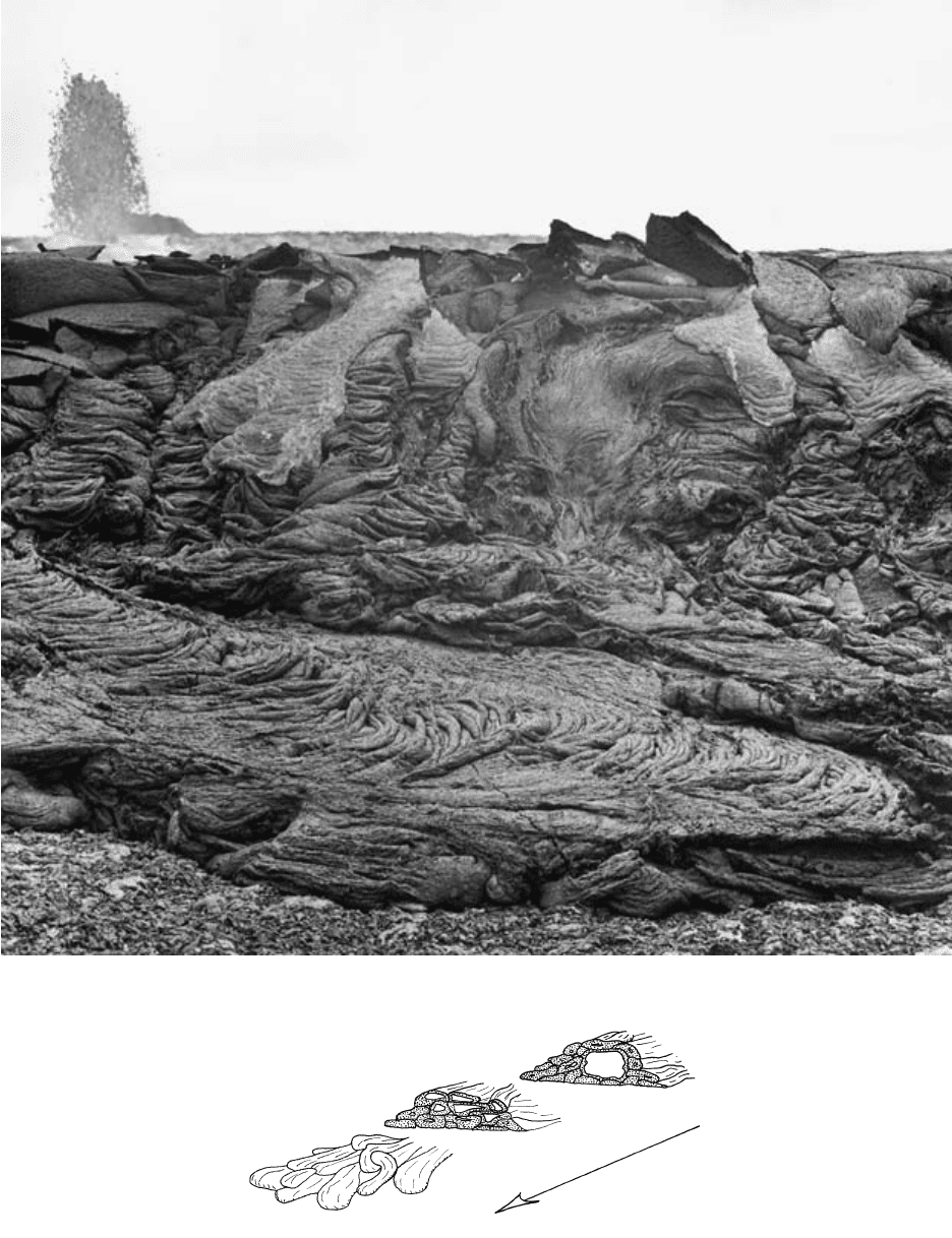
10.7 Pahoehoe lava flows. (a) Corded glassy pahoehoe tongues 1 m or so in width formed during the 1974 eruption of Mauna Ulu, Hawaii.
An active lava fountain playing in the left background over the vent feeds actively moving incandescent lava flow tongues that are some-
what lighter colored in this photograph. (U.S. Geological Survey photograph courtesy of Robin T. Halcomb.) (b) Schematic serial sec-
tions through a tube-fed pahoehoe flow showing major upstream lava tube and multiple smaller downstream distributary tubes. (Repro-
duced by permission from Rowland SK, Walker GPL. Pahoehoe and aa in Hawaii: Volumetric flow rate controls the lava structure. Bull.
Volcan. 52:615–628, 1990; copyright © 1990 by Springer-Verlag.)
Flow direction
(b)
flow can be several meters in diameter and many kilo-
meters long. If, as commonly happens, the lava drains
downslope from beneath the crusted skin, the tube
becomes an open cavity; these characterize exposed
subvertical sections through the interiors of solidified
pahoehoe flows (Figure 10.7b). On gentle slopes, elon-
gate pressure ridges and more equidimensional, dome-
like tumuli are elevated segments of pahoehoe flows in-
flated by more lava input or stranded highs between
drained segments. Crestal clefts or tension gashes are
commonplace.
Though commonly developed on land, pahoehoe
flows can also form subaqueously.
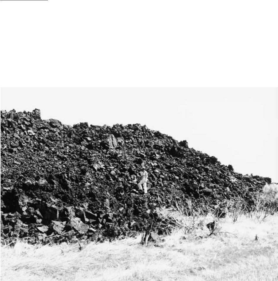
Aa and Block Flows. Aa flows are thicker than pahoe-
hoe and have exceedìngly rough, treacherous surfaces
of irregular, clinkerlike scoriaceous fragments (Figure
10.8). A complementary but thinner rubble layer lies at
the base. Flow advance is faster than pahoehoe so that
the tensile strength of the cool rigid crust is overcome
by the applied stress, causing autoclastic breakup. Heat
loss is also higher from the discontinuously exposed
incandescent core, causing increased downslope crys-
tallinity in the groundmass (Polacci et al., 1999), which
is another striking contrast from glassy pahoehoe. In-
creasing crystallinity produces more irregularly shaped
vesicles than the smooth-walled subspherical vesicles
of more glassy pahoehoe. Non-Newtonian rheology in
more crystalline lava may be manifested in plug flow
(Figure 8.13) and lava levées along channel margins
(Figure 10.2).
Block flows resemble aa but have a mantle of more
regularly shaped polyhedral chunks rather than jagged,
highly vesicular, scoriaceous clinker. Block flows range
from basaltic to highly silicic obsidian.
The contrasting morphological characteristics, as
well as observed transitions from pahoehoe to aa, never
the reverse, suggest that greater apparent viscosity pro-
motes development of aa (Wentworth and Macdonald,
1953). Any downslope loss of heat and gas (causing in-
creasing crystallization) allows near-vent pahoehoe to
become aa farther downstream. Degassing and increas-
ing nucleation and crystallization are promoted by
stirring; consequently lava flows plunging over steep
escarpments and lava produced by more vigorous
fountaining may change from pahoehoe to aa. More
viscous aa that is flowing faster with greater strain rate
(Peterson and Tilling, 1980) results in fragmentation of
the surface. Calm eruption and slow advance result in
pahoehoe.
248 Igneous and Metamorphic Petrology
10.8 Toe of aa lava flow in the Black Rock Desert monogenetic basalt field, west central Utah.
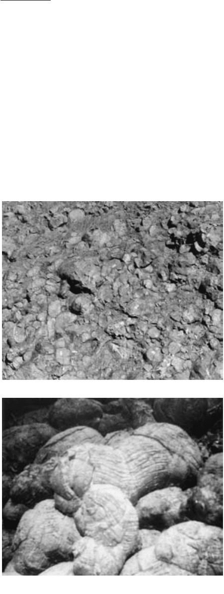
Pillow Lavas. Pillow lavas are usually of low-viscosity
basaltic magma formed where it comes into contact
with water or water-saturated sediment, even in shal-
low intrusive situations (Walker, 1992). Their most
widespread occurrence is on the seafloor where they
have developed by extrusion along spreading ridges
and on seamounts. Although having the appearance in
most exposures, such as roadcuts (Figure 10.9a), of a
pile of discrete, independent ellipsoids of pillow shape
and size, submarine pillow lavas in some outcrops and
especially those viewed on the seafloor in three dimen-
sions consist of a tangled mass of elongate, grooved, in-
terconnected flow lobes that are circular or elliptical in
cross section (Figure 10.9b). Flattening of the still hot,
not quite rigid pillows produces convex upward tops
and cusped bottoms that fill openings between under-
lying pillows. Such forms are useful indicators for the
field geologist of stratigraphic “right-side-up” direction
in deposits that have been tectonically tilted. Pillows
may resemble pahoehoe toes in cross section; they can
be distinguished by the lack of open ellipsoidal internal
tubes and the presence of fewer vesicles and radial con-
traction cracks. Pillows typically have a concentrically
zoned fabric (Figure 7.3) reflecting decreasing inward
rate of cooling. They may also be progressively en-
crusted with Mn-Fe oxides as the glassy envelope
“weathers” subaqueously to palagonite (Section 7.1.1).
Shattering of the hot glassy rinds of pillows in water
creates vitroclasts, discussed later.
Moore (1975) observed submarine pillows forming
off the 20°-sloping coast of Hawaii in tens of meters of
water. Toothpastelike protrusions of fresh lava squeeze
out of trapdoorlike openings in an upslope pillow; the
newly protruded pillow tongue may then detach and
roll away or, if it remains connected, may bud a new
protrusion. Pillow formation on flatter slopes has not
been observed.
Smooth-surfaced sheet lava flows and lava lakes
along oceanic rifts are apparently formed in deep water
by more rapid extrusion rates than those that create
pillow lavas.
10.2.2 Columnar Joints
All rocks are fractured, mostly because of tectonic
forces. However, most tabular bodies of magmatic
rock, especially aa lava flows and thin sheet intrusions
of basalt, have uniformly spaced columnar joints
formed by shrinkage during cooling (Figure 10.10).
Thermal contraction creates tensile stresses that ex-
ceed the brittle strength of the rigid magmatic body.
Resulting extensional cracks nucleate at more or less
equidistant points on the upper and lower margins of
a uniformly cooling tabular body. At each of these nu-
cleation points, a randomly oriented planar crack, or
perhaps a three-prong crack, forms and propagates
away from its point of origin along the essentially
isothermal surface of the flow until it intersects an ex-
tensional crack propagating from a neighboring nucle-
ation point. The network of cracks so formed consists
of rather regularly sized polygons with four, five, six, or
seven sides that resemble desiccation cracks in a thin
layer of drying, shrinking mud. As cooling and con-
traction advance into the tabular body, the polygonal
cracks likewise propagate inward, forming mostly
hexagonal joint columns; these represent the “least-
work” configuration of thermally induced tensile-stress
fractures in the magma body.
Joint columns have more than aesthetic appeal. Be-
cause they develop perpendicular to isothermal cooling
surfaces parallel to the margins of a cooling tabular
body, the configuration of the body, though its defining
margins are now possibly missing as a result of erosion,
Magma Extrusion: Field Relations of Volcanic Rock Bodies
249
10.9 Basaltic pillow lavas. (a) Roadcut at Nicasio Dam in the
Mesozoic Franciscan Complex north of San Francisco. (Pho-
tograph courtesy of Mary Hill.) (b) Submarine pillows at a wa-
ter depth of about 2 km along the Puna Ridge east of the is-
land of Hawaii. (Photograph courtesy of Hank Chezar and
D. J. Fornari.)
(a)
(b)
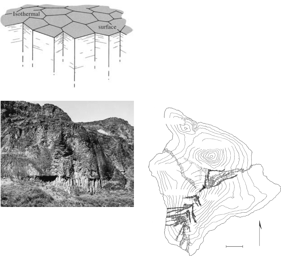
can be inferred (Figure 8.19c). The pattern of jointing
is useful in delineating individually emplaced cooling
units in a succession of volcanic deposits.
10.2.3 Subaerial Lava Accumulations
On land, the three most important types of basaltic
lava-built accumulations are, in terms of increasing vol-
ume, small basalt fields, shield volcanoes, and plateau-
forming floods.
Basalt fields form on flanks of larger composite and
shield volcanoes, within large calderas, and in other
continental areas. Vents may be localized along exten-
sional faults. Generally small (1 km
3
), monogenetic
extrusions produce simple tonguelike lava flows and
associated cinder cones (Figures 10.3 and 10.4). Where
rising basalt magma encounters water-saturated sedi-
ment or surface bodies of water (lakes), hydromag-
matic explosions produce tuff rings and maars (dis-
cussed later). In some places, a few lava flows may be
superposed but no thick pile is produced as in basalt
plateaus. The activity of a field may last a few millions
of years and create hundreds of volcanic edifices.
Shield volcanoes are built by innumerable extru-
sions of low-viscosity basaltic lava flows from a central
250 Igneous and Metamorphic Petrology
10.10 Columnar joints. (a) Schematic view of joint columns oriented
perpendicular to an isothermal surface in a cooling magma
body. See also Figure 8.19c. (b) Multitiered columnar joints in
a remnant of a 100-m-thick, ponded basalt lava flow now ex-
posed just above the Colorado River in the western Grand
Canyon, Arizona. Abruptly overlying a basal “colonnade” of
thick columns is the “entablature” of thinner columns.
Though seemingly haphazard, two radially oriented arrays can
be discerned on the left in the entablature. Many lava flows
find their way into drainage channels and are subsequently
overtopped by water, which penetrates down into the frac-
tured cooling lava flow. Margins of the radial arrays may de-
lineate where the water entered, locally depressing isothermal
surfaces. (Photograph courtesy of W.K. Hamblin.)
(b)
10.11 The island of Hawaii is built of seven coalescing shield volca-
noes. See also Figure 9.8. Four of these—Hualalai, Mauna
Loa, Kilauea, and Loihi—are active. Loihi seamount south of
Kilauea has not yet emerged above sea level. Extinct
Mahukona northwest of Hualalai has submerged isostatically
(Moore and Clague, 1992). Each shield grew over about 0.6
My. (a) Aa and pahoehoe lava flows, such as the historic flows
of Mauna Loa (patterned and labeled), build the subaerial
parts of the shields. These flows are extruded from flank fis-
sure (rift) systems and from a summit central vent complex.
Deeply eroded older shield volcanoes on older islands reveal
extensive feeder-dike swarms marking the fissure systems.
Topographic contours are thousands of feet above sea level.
(Redrawn from Stearns, 1966.) (b) Offshore bathymetry
(depth contours in km) and major submarine slumps (dark
shade), and debris avalanches (light shade). Double lines
through subaerial shields are rift zones through which most of
basaltic lava is extruded. AA line is line of cross section in (c).
(c) Enlarged cross section along AA in (b) of slump south of
east rift zone of Kilauea shield volcano showing subaerial lava
flows (subhorizontal lines), hydroclastic debris (dashed lines),
pillow lava (ellipses), sheeted feeder dikes (vertical lines), gab-
bro (dotted pattern), and magma (black). Dark shaded in
lower right is mantle. (Redrawn from Moore et al., 1994.)
KOHALA
MAUNA KEA
HUALALAI
MAUNA
LOA
KILAUEA
N
0mi10
0km16
1868
1877
1907
1916
1926
1919
1950
1832?
1950
1940
1926
1940
1851
1949
1942
1935
1855
1935
1942
1852
1880
1843
1750?
1859
(a)
(a)
vent complex and locally one or more fissure systems
radially disposed from it; the resulting edifice shape re-
sembles a warrior’s shield (Figures 9.8, 10.6, and
10.11). Small shields, as in Iceland and many continen-
tal areas, have diameters of a few kilometers. Shield
volcanoes find their greatest development in the
Hawaiian Islands. These gigantic edifices grew from
the seafloor by submarine extrusions (discussed later)
for tens to hundreds of thousands of years before even-
tually becoming subaerial. They are the largest volca-
noes on Earth, have diameters of over 100 km, and rise
as much as 10 km above their base on the seafloor.
(Mount Everest is only 8.85 km above sea level!) So
great is their weight that the oceanic lithosphere is
flexed downward, resulting in greater ocean depths im-
mediately around the isostatically subsiding island
mass. The largest island, Hawaii (Figure 10.11), has
grown over the past 0.6 My and is composed of seven
Magma Extrusion: Field Relations of Volcanic Rock Bodies
251
(b)
MAUI
156°
155°
0
0 km 100
mi 50
MAHUKONA
KOHALA
HUALALAI
MAUNA
KEA
MAUNA
LOA
KILAUEA
A
A
LOIHI
20°
19°
A
(c)
5
0
−5
−10
−15
Rift
zone
A
S.L.
806040
km
200
Oceanic crust
10.11 (Continued ).
coalesced shield volcanoes, the oldest of which is sub-
merged to the northwest; the youngest, to the south-
east, has not emerged above sea level. Gravitational in-
stability of the flanks of the compound shield edifice
causes recurrent landslides (Figure 10.11b, c). These
are more or less coherent slumps of a flank sector
whose slope is 3° as well as fast-moving chaotic de-
bris avalanches on gentler slopes, some of which have
gigantic volumes on the order of 5000 km
3
—the largest
avalanches known on Earth.
Plateau-forming, fissure-fed flood basalts are the
most voluminous subaerial lava extrusions of any com-
position known on Earth. Many continental plateaus
occur around the globe, including the Jurassic Karroo-
Ferrar in southern Africa and Antarctica, Paraná-
Etendeka in South America and southwestern Africa,
and the late Cretaceous-early Paleocene Deccan in
India (Figure 10.12). The Columbia River Plateau of
the northwestern United States (Figure 10.13) consists
of more than 100 flows emplaced in a remarkably brief
period of the Miocene—almost entirely 17–15 Ma
(Reidel and Hooper, 1989). Their aggregate volume is
about 180,000 km
3
, covering an area of 160,000 km
2
to
a depth as much as 3 km. By comparison, the large
Mauna Loa shield volcano on the island of Hawaii has
one-sixth this volume.
Individual large lava flows, literally floods, whose
stratigraphic correlation has been facilitated by “chem-
ical fingerprinting” using particular element concentra-
tions and ratios, range in volume from 90 km
3
to per-
haps as much as 3000 km
3
. Some flows traveled
hundreds of kilometers down gentle slopes of 1 m in
10 km (1/10,000). On the basis of a model of lava
transport in inflated pahoehoe flows, Self et al. (1997)
propose that the gigantic compound Roza flow field
(Figure 10.14) was emplaced over a period of 6–14 y
and individual flows in 5–50 months. Lava was able to
travel great distances because it did so under an insu-
lating pahoehoe crust and the only place where the
hottest mobile lava became exposed was at local break-
outs feeding new pahoehoe tongues. Calculated effu-
sion rates are about 4000 m
3
/s, which is comparable to
that of the 1783 Laki, Iceland, fissure eruption cited
previously. Though such discharge rates seem extraor-
dinary, the rate for the peak 2-My plateau-forming
episode is about 0.08 km
3
/y, comparable to discharge
rates of Hawaiian shield volcanoes and oceanic rifts.
In flood basalt plateaus, geologically rapid with-
drawal of 10
2
10
3
km
3
of magma did not result in
caldera collapse, as in silicic ash-flow eruptions of com-
parable volume (discussed later). Roofs over shallow
crustal silicic chambers tend to be thinner than their
spanning diameter and hence readily collapse. In con-
trast, roofs over magma reservoirs feeding basalt floods
that lie in the upper mantle, possibly the lower crust,
have sufficient thickness and strength to resist collapse
and merely subside over time. Discharge of huge vol-
umes of compositionally relatively uniform basalt
magma from the mantle raises questions regarding
magma generation and storage.
10.2.4 Submarine Basaltic Accumulations
Most submarine extrusions are of basaltic lava and ac-
count for most of global volcanism (Figure 1.1). Most
submarine activity involves fissure eruptions at oceanic
ridges, whereas more localized central eruptions have
built in excess of one million basaltic volcanoes dotting
the seafloor (Plate I). Most of these volcanoes are sub-
252 Igneous and Metamorphic Petrology
10.12 Plateau flood basalts exposed in the Western Ghat escarp-
ment of the Deccan Plateau, India. Photograph provided
courtesy of Peter R. Hooper. [Reproduced by permission from
Hooper PR. Flood basalt provinces. In Encyclopedia of Vol-
canoes, Sigurdsson H, Houghton B, McNutt SR, Rymer H,
Stix J, eds. 345–359:2000; copyright © 2000 by Academic
Press (a division of Harcourt Brace and Company).]
0 km 150
0 miles 100
Oregon
45°
Idaho
48°N
118°122°W
Washington
Pacific Ocean
10.13 Columbia River plateau flood basalts, northwestern United
States. Subparallel north-northwest-trending lines show the
approximate location and orientation of known groups of
feeder dikes that number in the thousands. Extent of Roza
flows (Figure 10.14) indicated by dashed line. (Redrawn from
Reidel and Hooper, 1989.)
merged seamounts 50100 m high; others have
grown from a submarine base (Figure 10.11c) into sub-
aerially exposed volcanic islands such as Hawaii.
The confining pressure exerted by seawater and es-
pecially the relatively low volatile concentrations in
basalt magmas preclude explosive eruptions in all but
the shallowest water depths. Because hydrostatic pres-
sure increases by about 1 bar ( 10
5
Pa) for every 10 m
of water depth and because oceanic ridge basalt mag-
mas typically have small water concentrations of
0.5 wt.%, exsolution is limited to water depths of
500 m (Figure 4.7). Ocean ridge basalt magmas may
contain concentrations of CO
2
comparable to that of
water but, because of its much lower solubility (Figure
4.10), may exsolve below the seafloor. Moreover, ex-
plosive fragmentation of magma due to bubble growth
cannot take place until some critical bubble volume
fraction develops, and this requires shallower depth for
bubble expansion. After a volcano has grown from the
deep seafloor to shallower depths of perhaps 200 m,
explosive fragmental deposits can be formed.
Magmatism along the 65,000-km-long system of
oceanic spreading ridges around the world (Fron-
tispiece and Plate I) is the most prolific on Earth (Fig-
ure 1.1). In concert with seafloor spreading, the en-
tire present-day oceanic crust has been produced in
200 My
.
Extrusions along oceanic ridges at water depths of a
few kilometers typically produce pillow lava and,
Magma Extrusion: Field Relations of Volcanic Rock Bodies
253
(a)
Washington
100
km
0
0
miles
50
Oregon
Idaho
(b)
(c)
(d)
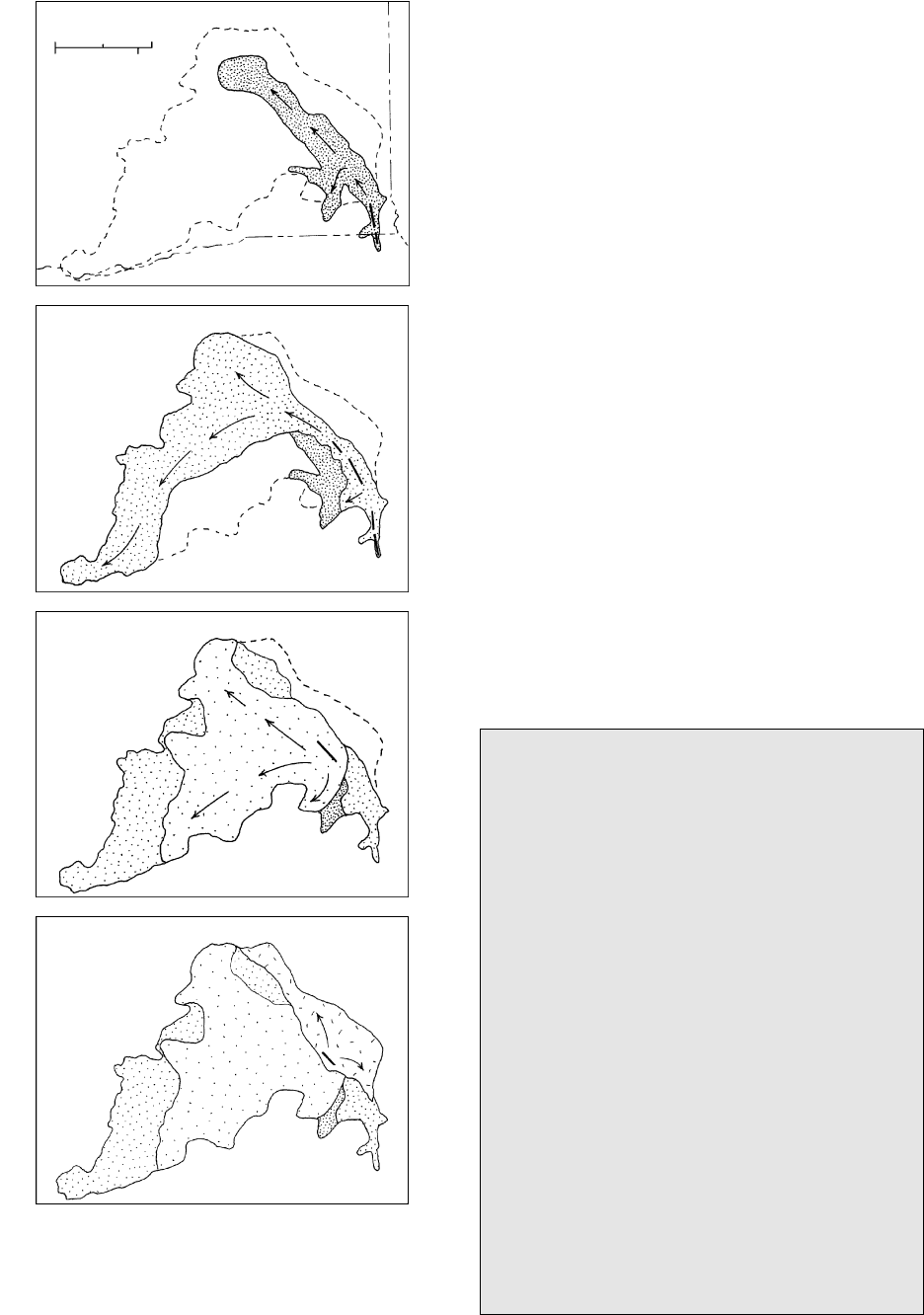
10.14 Schematic development of the Roza compound pahoehoe flow
field in the Columbia River plateau (Figure 10.13). Arrows in-
dicate direction of travel of basalt lava from fissure vent source
(heavy line) beneath the insulating pahoehoe crust. (Redrawn
from Self et al., 1997; Martin, 1989.)
Special Interest Box 10.1 Speculative trigger-
ing of El Niño by submarine basalt extrusions
In the last two decades of the 1900s, a major
anomaly in the weather pattern in some large conti-
nental areas surrounding the Pacific Ocean gained
considerable attention. This so-called El Niño is
caused by episodic perturbations at irregular recur-
rence intervals among sea surface temperatures, sea
level anomalies, and atmospheric wind stress. Shaw
and Moore (1988) have proposed a novel but con-
troversial hypothesis that El Niños might be trig-
gered by extrusion of large-volume submarine
basalt flows along the East Pacific Rise off the
northwest coast of South America. This is the fastest
oceanic spreading ridge in the world and is the area
where El Niños seem to be spawned. Shaw and
Moore speculate that some of these submarine flows
may have volumes and extrusion rates comparable
to those of the flood basalt lavas that formed conti-
nental plateaus. Every 1 km
3
of submarine basalt
that cools to ambient ocean temperatures within the
time of an El Niño cycle, they calculate, accounts
for about 1% of the anomaly.
where extrusion rates are greater, sheet lava flows, lo-
cally pahoehoe. Along the Mid-Atlantic Ridge, a
crestal rift valley, 20 to 30 km wide and 2 km deep, has
extensional fault-controlled terraces flanking a narrow
inner valley only a few kilometers wide and 100 to
400 m deep. Topographically controlled lava flows
on the inner valley floor are elongate (Figure 10.15).
Along the faster-spreading East Pacific Rise, lava lakes
have ponded on low-relief flanks. One youthful flow
discovered by side-looking sonar covers 220 km
2
and
has a volume estimated at 15 km
3
(Shaw and Moore,
1988).
Counterparts of the huge continental flood-basalt
plateaus were discovered during investigations of the
ocean floors in the late decades of the twentieth cen-
tury (Mahoney and Coffin, 1997). Oceanic plateaus are
broad topographic highs rising 1 km or so above the
surrounding seafloor and underlain by a crust as much
as 40 km thick, five to six times typical oceanic crust.
Little is known of these plateaus.
10.3 EFFUSIONS OF SILICIC LAVA
10.3.1 Morphological Characteristics and Growth
The most crystalline and, especially, the most silica-rich
lavas are the least mobile because of their high appar-
ent viscosities. Accordingly, silicic effusions have much
larger aspect ratios (thickness/length) than typically
sheet-like basaltic lava flows. A spectrum of shapes can
254 Igneous and Metamorphic Petrology
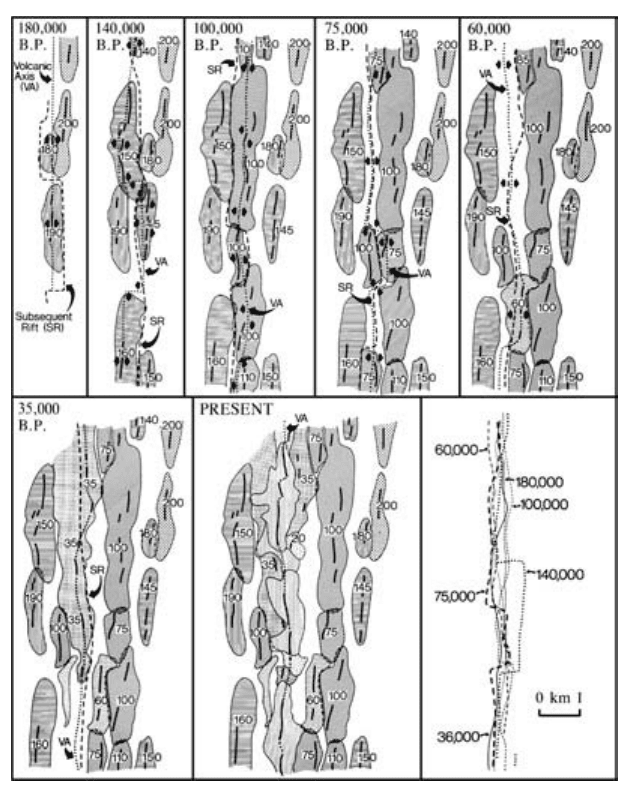
10.15 Evolution of the inner rift valley in the northern Mid-Atlantic Ridge at 36 50N latitude during the past 0.2 My. Shaded areas show
volcanic edifices built along the active volcanic axis (VA) that are later cut by a subsequent rift (SR). Lower right diagram combines
all of these rifts. Small numbers give ages of volcanic edifices in thousands of years. (From Ballard RD and van Andel TH, Morphology
and tectonics of the inner rift valley at lat 36 50N on the Mid-Atlantic Ridge. Geol. Soc. Am. Bull. 88:507–530, 1977; Reproduced
with permission of the publisher, The Geological Society of America, Boulder, Colorado USA. Copyright © 1977 Geological Society of
America.)
be recognized (Figure 10.16). The most mobile with
the smallest aspect ratio is the lava flow (Figure 10.17).
The more viscous mushroom-shaped lava dome (Fig-
ures 10.2, 10.5, 10.18) has a larger aspect ratio. The
still larger-aspect-ratio peléan dome resembles an arti-
choke and grows by expansion from within, pushing
slabs of rigid lava out of and away from the vent in fan
fashion or along sled-runner-shaped ramps. Although
most silicic effusions have blocky fractured tops and
surrounding aprons of blocky talus (Figure 7.33), these
are more pronounced in peléan domes. Slender spines
may be elevated above the remainder of the peléan
dome before being shattered by steam explosions or
thermal stresses or collapsing under their own weight.
Least mobile, rigid lava is extruded as an upheaved
plug, which is an elongate cylindrical mass roughly the
diameter of the vent conduit so that its aspect ratio is
1; a plug resembles a cork in a narrow-necked wine
bottle.
Many domes grow in craters (Figure 10.5) produced
by preceding explosive eruption of more volatile-
rich magma from the top of the supply chamber. Ex-
plosive activity may continue during the slow continu-
ous or episodic effusion of lava, which advances from
the vent at velocities of meters per hour to meters per
day. The duration of lava effusion can be many decades
in the case of large domes, such as the 1-km
3
growth
of Santiaguito, Guatemala, since 1922 (Rose, 1987).
In some effusions it is clear that new lava is slowly
added in an endogenous manner (Figure 10.19), inflat-
ing the interior beneath a more rigid carapace or cover
of closely packed blocks of lava. Other effusions are
exogenous and grow by addition of lava onto the
surface.
Dome growth may be modeled in two ways, as a
brittle shell enclosing pressurized magma or as vis-
coplastic lava. In the viscoplastic model (Blake, 1990;
see also Section 8.2.2), the chilled carapace of a low
lava dome has yield strengths of 10
5
10
6
Pa, whereas a
steeper-sided peléan dome, whose form is dictated as
much by its talus apron as by the rheology of the lava
core, has a yield strength 10
6
10
7
Pa.
Autoclastic fragments, generally of block size, man-
tle flows and domes and form talus aprons around
them (Figure 7.33). Fragments are created by move-
ment of the rigid carapace, thermal stresses, or internal
gas pressure, or by collapse under their own weight.
As the effusion advances laterally, the clastic apron may
be pushed aside or overridden and possibly engulfed
within the flow. Larger-volume crumbling of sectors of
the steep dome and plug margins on summits or on
slopes of larger volcanoes creates avalanches of consid-
erable runout, as in the Chaos Jumbles in Figure 10.18.
More explosive shattering generates devastating pyro-
Magma Extrusion: Field Relations of Volcanic Rock Bodies
255
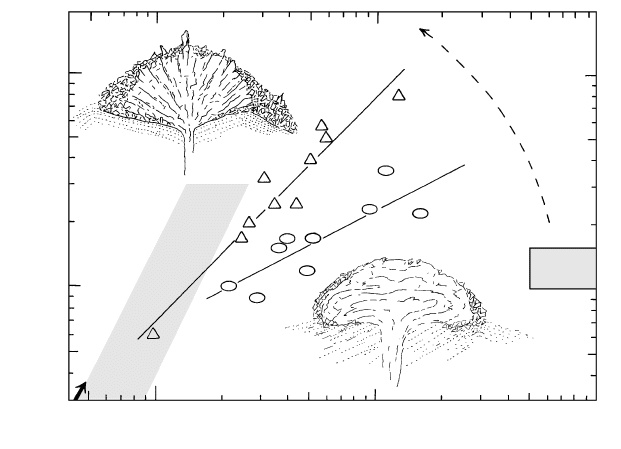
Upheaved plug
100
1000
10,000
Radius, R (m)
Low lava dome
SW
Idaho
lava flows
I
N
C
R
E
A
S
I
N
G
Y
I
E
L
D
S
T
R
E
N
G
T
H
100
1000
Height, H (m)
0.55
H/R = 1.06
Pelean
dome
'
10.16 Shapes of silicic effusions. Cross sections through typical low lava dome and peléan dome, both resting on precursory pyroclastic de-
posits, shown as dotted lines. (Redrawn from Williams, 1932.) Note aprons of mostly block-size talus. Measured dome height, H, versus
dome radius, R, of selected low lava domes (ellipses) and peléan domes (triangles) around the world are plotted with a best-fit line rep-
resenting the indicated aspect ratio, H/R. (Redrawn from Blake, 1990.) The aspect ratio of peléan domes is similar to the tangent of an-
gles of repose of the talus pile of unconsolidated fragments that typically surround them. Note that these talus accumulations are signif-
icantly less around low lava domes. Shaded rectangle on right represents large-volume (as much as 200 km
3
), high-T rhyolite lava flows
in southwestern Idaho. (From Bonnichsen and Kauffman, 1987.) Shaded band on left represents possible aspect ratios for high-yield-
strength upheaved plugs. As silicic lava emerges from a vent (arrow, lower left), with increasing height, H, it may grow into a lava flow,
low lava dome, peléan dome, or upheaved plug depending on increasing yield strength.
clastic avalanches that cascade with hurricane speed
downslope.
10.3.2 Internal Fabric
Planar and linear fabric elements are widespread in sili-
cic effusions and constitute markers of the pattern of
internal flow in the body during emplacement. More or
less planar flow layering (Figures 7.4 and 7.41) ex-
pressed by textural variations (crystal size, crystallinity,
vesicularity) in a wide range of lava viscosities reflects
laminar flow. Contorted and folded flow layers reflect
local changes in flow velocity or drag, particularly near
flow margins. Grooves and striations, which resemble
slickenlines on fault surfaces, and associated transverse
open tension gashes also develop on shear surfaces in
viscous lava.
Rhyolite flows and domes have a more or less con-
sistent vertical internal zonation of fabric developed by
variable vesiculation, fragmentation, and devitrification
superposed on rheologic flow. This zonation serves as a
useful field guide in the interpretation of poorly ex-
posed old flows. Thicknesses of zones vary consider-
ably, and a particular zone may not be everywhere
present. Tops and bottoms of the extrusion are of au-
tobreccia that is variably vesiculated, as are local inter-
nal seams representing brecciated flow margin material
engulfed during flow or zones of rigid magma that were
fragmented. Interiors are flow-layered. Young effusions
256 Igneous and Metamorphic Petrology
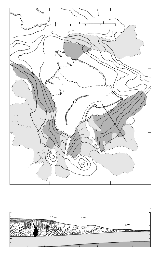
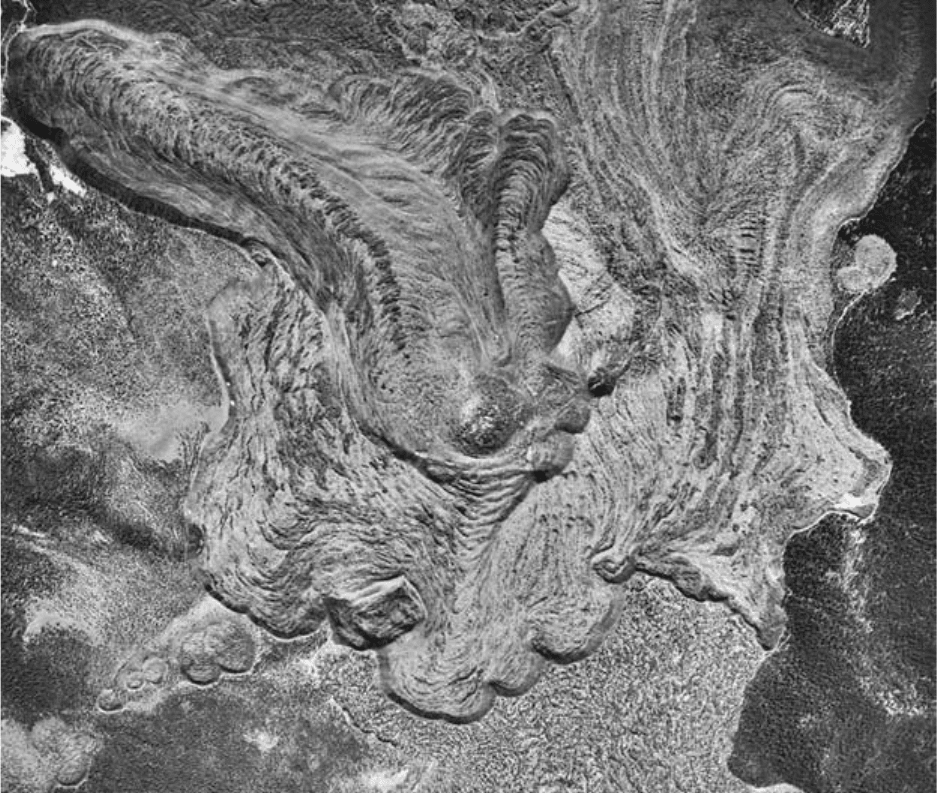
10.17 Vertical aerial photograph of Big Glass Mountain rhyolite obsidian flow east of Mount Shasta, California. Main tongue toward upper left
is nearly 3 km long, has a thickness of about 75 m, and flowed down an approximate 9 slope from the vent near photo center. Arcuate
pressure ridges in flow surface transverse to flow direction that are spaced about 60 m apart with amplitudes averaging 8 m possibly orig-
inated through compressional drag forces exerted in the more rigid flow surface by the underlying hotter, more mobile flowing interior.
Note east-northeast trending line of extrusive vents beginning at lower left corner and ending at upper right that were probably con-
trolled by a fissure. (Photograph by U.S. Forest Service.)