Odekon M. Encyclopedia of paleoclimatology and ancient environments
Подождите немного. Документ загружается.


Retallack, G.J., 2001. Soils of the Past: An Introduction to Paleopedology,
2nd edn. London, UK: Blackwell Science Ltd, 404pp.
Sheldon, N.D., Retallack, G.J., and Tanaka, S., 2002. Geochemical
climofunctions from North American soils and application to paleosols
across the Eocene-Oligocene boundary in Oregon. J. Geol., 110,
687–696.
Sheldon, N.D., 2005. Do red beds indicate paleoclimatic conditions?: A
Permian case study. Paleogeography, Palaeoclimatology, Palaeogeogra-
phy, 228, 305–319.
Walker, T.R., 1967. Formation of red beds in modern and ancient deserts.
Bull. Geol. Soc. Am., 78, 353–368.
Yapp, C.J., and Poths, H., 1992. Ancient atmospheric CO
2
pressures
inferred from natural goethites. Nature, 355, 342–344.
Cross-references
Arid Climates and Indicators
Atmospheric Evolution, Earth
Banded Iron Formations and the Early Atmosphere
Continental Sediments
Evaporites
Laterite
Mineral Indicators of Past Climates
Paleoclimate Proxies, an Introduction
Paleosols, Pre-Quaternary
Paleosols, Quaternary
Paleo-Precipitation Indicators
Sedimentary Indicators of Climate Change
ROCHES MOUTONNE
´
ES
Roches moutonnées are classic landforms of glacial erosion
(Bennett and Glasser, 1996). They are giant stoss and lee forms
carved from bedrock, with smoothly abraded up-ice or stoss
faces and roughly quarried/plucked down-ice lee faces. They
can occur as isolated forms, can be superimposed on larger
asymmetric landforms, or occur as part of erosional landscapes
subject to regional scour. Individual forms vary in size from
less than 1 m to several hundred meters or even kilometers in
diameter (Rastas and Seppälä, 1981). In Sweden, for example,
large asymmetric hills (Flyggbergs) exceed 1 kilometer in
length; however, most roches moutonnées are much smaller.
Roches moutonnées are the product of both glacial abrasion
and glacial quarrying and it is this combination of processes
that results in the asymmetric profile. Glacial abrasion occurs
on the up-ice or stoss face of the landform, while glacial
quarrying occurs on the lee. Glacial quarrying involves two
processes, firstly the exploitation and propagation of rock frac-
tures such as joints and discontinuities, and secondly, the
entrainment and removal of bedrock blocks by ice. The charac-
teristics of the rock mass, therefore, are critical to quarrying:
the more fractured the rock mass, the more easily it can be
plucked by ice. In turn, this means that the morphology of
roches moutonnées is closely linked to the depth, orientation
and spacing of joints or discontinuities within the rock mass
(Gordon, 1981; Rastas and Seppälä, 1981). The exploitation
and propagation of joints is assisted by fluctuations in subgla-
cial water pressure (Röthlisberger and Iken, 1981; Iverson,
1991). In addition, the formation of a lee-side cavity between
the ice sole and the bed increases the stress gradients imposed
on the bedrock hummock by the overriding ice, which again
favors fracture propagation. Block entrainment may occur by
a variety of processes, not least of which is the regular closure
of the lee-cavity, causing the debris within it to be swept clear.
Therefore, roches moutonnées are indicative of subglacial con-
ditions in which there is high effective normal pressure on the
stoss side of a bedrock bump, but where this pressure is suffi-
ciently low on the down-ice side to allow a cavity to form.
Consequently, the up-ice side experiences glacial abrasion,
while the down-ice side experiences glacial quarrying. Roches
moutonnées tend, therefore, to form in areas of thin, fast-
flowing ice and in situations with abundant meltwater. They
may also be used as crude indicators of the direction of ice flow.
Matthew R. Bennett
Bibliography
Bennett, M.R., and Glasser, N.F., 1996. Glacial Geology: Ice sheets and
Landforms. Chichester, UK:Wiley, 364pp.
Gordon, J.E., 1981. Ice-scoured topography and its relationship to bedrock
structure and ice movement in parts of northern Scotland and West
Greenland. Geografiska Annaler, 63A,55–65.
Iverson, N.R., 1991. Potential effects of subglacial water pressure fluctua-
tions on quarrying. J. Glaciol., 37,27–36.
Rastas, J., and Seppäla, M., 1981. Rock jointing and abrasion forms on
roches moutonnées, SW Finland. Ann. Glaciol., 2, 159–163.
Rothlisbeger, H., and Iken, A., 1981. Plucking as an effect of water-
pressure variations at the glacier bed. Ann. Glaciology, 2,57–62.
Cross-reference
Glacial Geomorphology
ROCHES MOUTONNE
´
ES 873

S
SAPROPELS
The term sapropel is used in a generic sense to describe fine-
grained and unconsolidated sediments rich in organic matter
that have been deposited under water; in coal petrology,
sapropelic coals are those that formed from algal material
deposited in aquatic environments. The term sapropel is also
often used as a generic term for distinct dark-colored, organic
carbon-enriched sediment layers that are found in organic-
carbon-poor host sediments. In the Holocene sediment record
of several silled basins (e.g., the Baltic Sea, the Black Sea,
the Marmara Sea) an organic carbon-enriched sediment layer –
often termed sapropel – marks the change in depositional
environment and in biological production coincident with the
post-glacial transgression.
In a stricter sense, the term stands for a sedimentary feature
of the Mediterranean (and Red) Sea with specific connotations
regarding the origin: sediment cores and land exposures from
the Mediterranean Sea contain rhythmic series of sapropel
layers (cm to m thick) sandwiched in carbonate-rich and
organic carbon-poor hemipelagic sediments. These sapropels
are rich in organic carbon (up to 30% by weight), devoid of
benthic organisms and often laminated, and were deposited
during periods when the deep waters of the marine basins
were anoxic (Comas et al., 1996; Kidd et al., 1978; Emeis
et al., 2000). The duration of the numerous anoxic events in
the Mediterranean Sea was from a few hundred up to 7,000
years, and the most recent sapropel was deposited between
10,000 and 7,000 years ago. The observed temporal pattern
of sapropel deposition is clearly paced by the orbital rhy-
thms of precession, tilt and eccentricity and implies a causal
link with orbitally-induced climate change that resulted in
changes of the Mediterranean water balance (Cita et al., 1977;
Rossignol-Strick, 1983). The link between insolation and sapro-
pel deposition in the eastern Mediterranean Sea is very robust
for the last 5.33 million years and the astronomically-tuned
stratigraphy established here has set a standard for Pliocene
and Quaternary chronostratigraphy world-wide (Hilgen, 1991).
The close link between climate and sapropel formation
is firmly established, and a hydrological trigger for sapropel
formation is widely agreed. Sapropel periods were preceded
by and coincided with changes in surface and deep water circu-
lation that restricted the oxygen supply to the seafloor in the
deep basins of the Mediterranean Sea. At present, the deep
basins of the Mediterranean Sea are flushed by cold, oxygen-
rich waters that are generated during winters in the northern
sub-basins – the Gulf of Lyons, the Aegean, and the Adriatic
Seas. One prerequisite for anoxic conditions during periods of
sapropel formation was a decrease in surface water density
(relative to that of deepwater masses) that prevented sinking
of oxygenated surface water into the deep basins. Both freshen-
ing (indicated by decreasing ratios of stable oxygen isotopes in
the tests of planktonic foraminifers and changes in microfossil
assemblages) and increasing sea surface temperature (based
on evaluation of faunal assemblages and biomarkers) of surface
water preceded and accompanied all sapropel events. Because
oxygen demand for the mineralization of organic matter that
sank from the surface ocean to the deepwater masses contin-
ued, the dissolved oxygen in the denser and aging deepwater
eventually was depleted. The origin of fresh waters is less clear.
The original hypothesis (Olausson, 1961) was that meltwater
from the northern catchment (via the Black Sea) prevented
deepwater formation. Alternatively, the northern catchment of
the eastern Mediterranean Sea may have received increased
precipitation during maximum insolation, leading to decreased
salinity in the deepwater formation areas of the Mediterranean
Sea (Rohling and Gieskes, 1989). However, since approxi-
mately 600,000 years ago, sapropels were deposited under fully
interglacial, fully glacial, and intermediate climatic conditions.
Because conditions during glacials or cold stadials were
as unfavorable for runoff from the northern catchment as
for water-column stratification due to warming of the surface
layer, sapropel formation even under glacial conditions is
a strong argument for a source of freshwater in the monsoon
system that influences mainly the southern catchment. Accord-
ing to this hypothesis, sapropel formation would be closely
linked to tropical and even Southern Hemisphere climate.
A systematic correlation has been observed between the

distribution of sapropels and maxima of the so-called orbital
insolation monsoon index (Rossignol-Strick, 1983). Maxima
in the monsoon index point to an intensified African summer
monsoon, which may have led to enhanced continental humid-
ity in tropical Africa and ultimately enhanced discharge rates of
the Nile River. Alternatively, enhanced northward migration of
the Intertropical Convergence Zone (the meteorological equator)
into Northern Africa has been proposed for sapropel periods; this
would have channeled equatorial rainfall into the Mediterranean
Sea through what is now the Sahara Desert. A further possible
source of freshwater is the Mediterranean Sea itself: virtually
all sapropels coincide with significant warming of surface waters
at the transition from cold to warm climatic periods. This warm-
ing would on the one hand enhance the stratification of water
masses and would on the other hand result in increased evapora-
tion and rainfall in the Mediterranean catchment, effectively
pooling fresh and warm waters at the sea surface and impeding
deepwater formation. It is very likely that all of these sources
contributed in succession and in concert to prevent deep convec-
tion over several thousands of years.
The immediate reason for the enrichment of organic matter
in sapropels is very much open to discussion. Oxygen condi-
tions at the seafloor, biological productivity at the sea surface,
and dilution by other sedimentary components are the primary
factors controlling concentration and accumulation of organic
carbon in marine sediments. Because the rates of sedimenta-
tion did not change significantly, the scientific discussion
focused on the roles of bottom-water anoxia and biological
productivity changes in the formation of organic carbon-rich
sediments (“productivity versus preservation”). Much of the
data gathered support the hypothesis of anoxic conditions
paired with (or possibly accelerated and in part caused by) an
increase in biological productivity during sapropel formation.
In line with this, many indicators suggest enhanced pro-
ductivity (assemblages of planktonic and – before and after the
sapropel events – benthic foraminifers, the accumulation rates
of barium). However, other authors see evidence that the eastern
Mediterranean Sea remained nutrient-limited (oligotrophic) and
that productivity patterns either shifted to a different type,
or were as low as today. A severe obstacle for environmental
reconstructions here as elsewhere is diagenesis that erases many
indicators after deposition and re-oxygenation of deepwaters.
Detailed investigation of diatom assemblages in one unusually
thick sapropel in which biogenic silica was preserved (in the
carbonate oozes and in almost all other sapropels, this opal is
lost to dissolution) showed that the original sapropel sequence
was rich in diatoms that formed a pronounced sequence of
laminations, including possible annual bloom layers. The flora
consisted of fragile mats of diatoms indicative of stratified,
oligotrophic conditions found in association with hydrographic
frontal systems. Collecting near the interface between upper
and lower water mass in the frontal system, the disintegration
of slowly grown mats with large biomass may sporadically
have resulted in large flux rates of opal and organic matter to
the seafloor (Kemp et al., 1999). Other authors (Sachs and
Repeta, 1999) proposed that the productivity level remained
similar to the present ultra-oligotrophic nutrient desert during
sapropel formation, because cyanobacterial nitrogen fixation
then as today apparently was a significant source of the essential
plant nutrient nitrate in the water column. In this scenario, anoxia
alone was responsible for greatly improved preservation of the
sparse rain of organic matter to the seafloor. More recently,
the role of phosphate liberated from anoxic sediments as a fuel
for enhanced fixation of atmospheric nitrogen by cyanobacteria
has been stressed (Struck et al., 2001; Slomp et al., 2002). In this
view, the eastern Mediterranean Sea was fertilized by phosphate
diffusing out of suboxic and anoxic sediments. This additional
phosphate may have been transported to the surface ocean by
ongoing shallow seasonal convection. It may thus have created
conditions conducive for massive nitrogen fixation from the
atmosphere that added nitrate, and initiated a positive feedback
between anoxia at the seafloor and biological productivity in
the euphotic zone. The anoxic and fertile sapropel periods ended
with the waning of freshwater inputs and warming, and renewed
flushing of the deep basins with oxygenated waters. In many
cases, the sapropel preceding this flushing was erased by oxygen
penetrating into the sediment, burning down the organic matter,
and leaving so-called ghost sapropels.
Conclusion
Formation of the Mediterranean sapropels is the result of
a combination of factors that include paleoclimate, paleocea-
nography, and the reactions of marine biogeochemical cycles
to changed boundary conditions. Whereas the mechanism of
sedimentation and carbon burial can be linked to changes
within the depositional environment, these very changes are
likely to be forced by processes outside the basin. External for-
cing is evident from the synchroneity of sapropel deposition i n
the entire (eastern) Mediterranean. Moreo ver, the rhythmi c
recurrence of environmental conditions that produce sapropels
on schedules of precessional cycles points to a climatically dri-
ven chain of events culminating in sapropel deposition. A ten-
tative chain of events postulates that carbon burial may have
been promoted by enhanced rates of marine productivity,
fuelled by an as ye t contested source of new nutrients, a corre-
sponding increase in oxygen utilization in deep water, and a
weakening of deepwater oxygen recharge which all occur at
the same time and are driven by the same external motor.
Kay-Christian Emeis
Bibliography
Cita, M.B., et al., 1977. Paleoclimatic record of a long deep-sea core from
the eastern Mediterranean. Quaternary Res., 8, 205–235.
Comas, M.C., Zahn, R., Klaus, A., et al., (eds), 1996. Proceedings ODP,
Initial Results, Vol. 161. College Station, TX: Ocean Drilling
Program, 1023 pp.
Emeis, K.-C., Sakamoto, T., Wehausen, R., and Brumsack, H.-J., 2000. The
sapropel record of the Eastern Mediterranean Sea – Results of Ocean
Drilling Program Leg 160. Palaeogeogr. Palaeoclimatol. Palaeoecol.,
158, 259–280.
Hilgen, F.J., 1991. Astronomical calibration of Gauss to Matuyama
sapropels in the Mediterranean and implication for the Geomagnetic
Polarity Time Scale. Earth Planet. Sci. Lett., 107, 226–244.
Kemp, A.E., Pearce, R.B., Koizumi, I., Pike, J., and Rance, J., 1999.
The role of mat-forming diatoms in the formation of Mediterranean
sapropels. Nature, 398,57–61.
Kidd, R.B., Cita, M.B., and Ryan, W.B.F., 1978. Stratigraphy of eastern
Mediterranean sapropel sequences recovered during Leg 42A and their
paleoenvironmental significance. In Hsü K., and Montadert, J.L. (eds.),
Initial Reports of DSDP. Washington, US: Govt. Printing Office,
pp. 421–443.
Olausson, E., 1961. Studies in deep-sea cores. Rep. Swed. Deep Sea
Exped., 8, 337–391.
Rohling, E.J., and Gieskes, W.W.C., 1989. Late Quaternary changes
in Mediterranean intermediate water density and formation rate.
Paleoceanography, 4(5), 531–545.
Rossignol-Strick, M., 1983. African monsoons, an immediate climate
response to orbital insolation. Nature, 304,46–49.
876 SAPROPELS
Sachs, J.P., and Repeta, D.J., 1999. Oligotrophy and nitrogen fixation dur-
ing Eastern Mediterranean sapropel events. Science, 286, 2485–2488.
Slomp, C.P., Thomson, J., and deLange, G.J., 2002. Enhanced regeneration
of phosphorus during formation of the most recent eastern Mediterra-
nean sapropel (S1). Geochim. Cosmochim. Acta, 66(7), 1171–1184.
Struck, U., Emeis, K.-C., Rau, G.H., Voss, M., and Krom, M., 2001.
Biological productivity during sapropel S5 formation in the eastern
Mediterranean Sea – Evidence from stable isotopes of nitrogen and
carbon. Geochim. Cosmochim. Acta, 65(19), 3241–3258.
Cross-references
Coal Beds, Origin and Climate
Diatoms
Eccentricity
Intertr opical Convergence Zone (ITCZ) (see Encyclopedia of World
Climatology)
Monsoons, Quaternary
Obliquity
Ocean Anoxic Events
Precession, Climatic
SCANDINAVIAN ICE SHEET
The Scandinavian and adjacent ice sheets
The Scandinavian Ice Sheet is the most commonly used name
for an ice sheet that developed over Scandinavia many times
during the Quaternary period. It is sometimes called the
Fennoscandian Ice Sheet (Fenno = Finland), but as it expanded
from the Scandinavian mountains and did not always reach
Finland, the Scandinavian Ice Sheet is the most proper name.
At its maximum extent, it covered northwestern Europe as
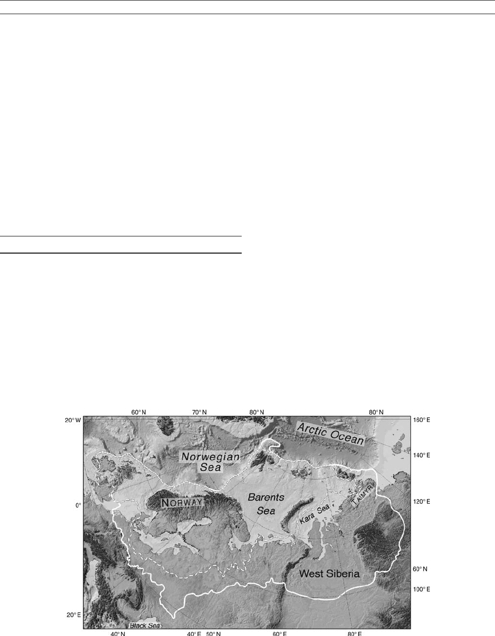
far south as the Netherlands (Figure S1). In Eastern Europe it
almost reached the Black Sea in southern Ukraine.
During some periods of maximum development, the
Scandinavian Ice Sheet coalesced with the Barents-Kara Ice
Sheet, which was centered over the Barents and Kara Seas,
and expanded southwards onto Northern Russia and Siberia
(Figure S1). At such times, there was a contiguous ice sheet
stretching from north of Spitsbergen to the Netherlands and
from the Norwegian Sea to the Taimyr Peninsula in Siberia.
The Scandinavian Ice Sheet also occasionally met the British
Ice Sheet in the North Sea, but these two ice sheets were
topographically and dynamically more clearly separated than
those discussed above.
The older Scandinavian Ice Sheets
The strong glacial erosion associated with the last ice sheets
has removed most of the deposits of the older glacials and
interglacials. Glacial erosion also transformed the landscape
so that deep U-shaped valleys and fjords now are common,
especially in western Norway where vertical erosion of 1,900
m is inferred for part of Sognefjorden (Andersen and Nesje,
1992). The main record of older glaciations is the ice-rafted
debris (IRD) found in cores collected from the floor of the deep
Norwegian Sea. IRD indicates that the first ice sheets formed
in Scandinavia as early as 11 million years ago, whereas the
largest ice sheets grew after about 2.7 million years ago (Jansen
and Sjøholm, 1991; Mangerud et al., 1996).
It is not known how many times the ice sheet expanded
south of Scandinavia. In Germany, there are tills from only
three glaciations, the Elsterian, Saalian and Weichselian (Ehlers,
1996). Thus, the classical view is that only at these times did the
ice sheet reach this far south. However, Scandinavian erratics
found in the Netherlands and glacial deposits in the North Sea
indicate that such expansion also happened before the Elsterian
(Mangerud et al., 1996).
The last ice age – the Weichselian
The last ice age in Northern Europe is named the Weichselian
from the German name of the Vistula River in Poland,
where glacial deposits from the Scandinavian Ice Sheet were
Figure S1 Map showing the extent of the Scandinavian, Barents-Kara and British Ice Sheets during two periods. Full line shows the Saalian
glaciation and stippled line the Late Weichselian glaciation. (Modified from Svendsen et al., 2004.)
SCANDINAVIAN ICE SHEET 877

described by German geologists shortly after 1900 (Ehlers,
1996). We now know that these deposits were formed late dur-
ing the last ice age, about 20,000 years ago. However, the name
Weichselian is accepted for the entire cold period following
the last interglacial in Europe, the Eemian. The subdivision
and time scale for the Weichselian is shown in Figure S2.
The growth and decay of the Scandinavian and adjacent
ice sheets is obviously much better known for the Weichselian
than for older glaciations (Ehlers and Gibbard, 2004). How-
ever, in most areas, the ice sheets were larger during the
Late Weichselian (about 20,000 years ago) than during earlier
phases of the Weichselian. Therefore, our knowledge of the
first 90,000 years of the Weichselian is limited.
Figure S2 shows a glaciation curve for western Norway
for the entire Weichselian (Mangerud, 2004). During the
last interglacial, the Eemian, the climate was warmer than at
present, and no glacier existed. The first ice advance (Gulstein)
almost reached the coast as early as 110,000 years ago.
Subsequently the ice front retreated during the Brørup intersta-
dial when open forests were established over much of Scandi-
navia (Lundqvist, 1992). As seen from the curve, the ice
margin subsequently advanced and retreated several times dur-
ing the Weichselian. There were probably several more fluctua-
tions than so far identified, although the record of ice rafted
detritus in cores from the Norwegian Sea supports the main
picture (Figure S2).
It is worth noting that the coast and probably much of the
interior of Scandinavia was ice free during and possibly even
after the Ålesund interstadial, which ended about 34,000 years
ago (Olsen et al., 2002; Mangerud et al., 2003). This means
that the ice sheet grew rapidly after this interstadial, until it
reached its maximum size about 24,000 years ago.
The extent of the Late Weichselian Ice Sheet is shown in
Figure S1. In Denmark, Germany and Poland, the limit of this
ice sheet has been known for more than a century (Ehlers,
1996). However, it is still debated whether the British and
Figure S2 The right hand curve shows fluctuations of the western margin of the Scandinavian Ice Sheet. The lower part of the curve, when the
ice front ended at the margin of the continental shelf corresponds with the Saalian ice limit in Figure S1. During the Eemian, the ice sheet
disappeared. During the Weichselian, the extent of the ice sheet fluctuated strongly, but about 24,000 years ago it again reached the margin of the
continental shelf, as shown in Figure S1. To the left are curves showing the number of ice rafted sand grains and their accumulation rates in
cores from the Norwegian Sea (Mangerud, 2004).
878 SCANDINAVIAN ICE SHEET

Scandinavian Ice Sheets met in the North Sea, although that is
assumed on the map. Furthermore, the limit of the ice sheet in
Northern Russia has been much debated. A serious problem
there is that permafrost with buried glacial ice melted at the
end of the Weichselian and created fresh glacial landscapes,
even though it had been deglaciated for tens of thousands of
years (Svendsen et al., 2004).
The Barents-Kara Ice Sheet
The Barents Sea is located immediately north of Scandinavia,
but the Scandinavian and Barents-Kara Ice Sheets did not
always react in concert. The Barents-Kara Ice Sheet was much
larger during the Early (about 90,000 years ago) and Middle
Weichselian (60,000– 50,000 years ago) than during the Late
Weichselian, in contrast to the Scandinavian and the North
American Ice Sheets (Svendsen et al., 2004). During both these
periods, the Barents-Kara Ice Sheet moved onto land in
Northern Russia, whereas during the Late Weichselian it termi-
nated in the sea ( Figure S1). During the Early Weichselian,
the northbound rivers in Northern Russia were blocked by the
ice sheet and large ice-dammed lakes formed between the
ice-sheet and the continental watershed to the south.
Jan Mangerud
Bibliography
Andersen, B.G., and Nesje, A., 1992. Quantification of Late Cenozoic gla-
cial erosion in a fjord landscape. Sveriges Geologiska Undersökning Sr.
81,15–20.
Ehlers, J., 1996. “Quaternary and glacial geology.” Chichester, UK:
Wiley.
Ehlers, J., and Gibbard, P. (eds.), 2004. “Quaternary Glaciations – Extent
and Chronology. Part 1: Europe.” Amsterdam: Elsevier.
Jansen, E., and Sjøholm, J., 1991. Reconstruction of glaciation over
the past 6 million years from ice-borne deposits in the Norwegian
Sea. Nature, 349, 600–604.
Lundqvist, J., 1992. Glacial Stratigraphy in Sweden. Geological Survey of
Finland Special paper 15, pp. 43–59.
Mangerud, J., 2004. Ice sheet limits on Norway and the Norwegian continen-
talshelf.InEhlers,J.,andGibbard,P.(eds.),“Quaternary Glaciations –
Extent and Chronology. Part 1: Europe.” Amsterdam: Elsevier .
Mangerud, J., Jansen, E., and Landvik, J., 1996. Late Cenozoic history of
the Scandinavian and Barents Sea ice sheets. Glob. Planet. Change,
12,11–26.
Mangerud, J., Løvlie, R., Gulliksen, S., Hufthammer, A.-K., Larsen, E.,
and Valen, V., 2003. Paleomagnetic correlations between Scandinavian
Ice-Sheet fluctuations and Greenland Dansgaard-Oeschger Events,
45,000–25,000 y
BP. Quaternary Res., 59,211–220.
Olsen, L., Sveian, H., van der Borg, K., Bergstrøm, B., and Broekmans, M.,
2002. Rapid and rhythmic ice sheet fluctuations in western Scandinavia
15–40 Kya – areview.Polar Res., 21,235–242.
Svendsen, J., Alexanderson, H., Astakhov, V., Demidov, I., Dowdeswell, J.,
Funder, S., Gataullin, V., Henriksen, M., Hjort, C., Houmark-Nielsen, M.,
Hubberten, H., Ingólfson, O., Jakobsson, M., Kjær, K., Larsen, E.,
Lokrantz, H., Lunkka, J., Lyså, A., Mangerud, J., Matiouchkov, A.,
Murray, A., Möller, P., Niessen, F., Nikolskaya, O., Polyak, P.,
Saarnisto, M., Siegert, C., Siegert, M., Spielhagen, R., and Stein, R.,
2004. Late Quaternary ice sheet history of Northern Eurasia. Quaternary
Sci. Rev., 23,1229–1271.
Cross-references
Eemian (Sangamonian) Interglacial
Glaciations, Quaternary
Ice-Rafted Debris (IRD)
Interstadials
Last Glacial Maximum
Wisconsinan (Weichselian, Würm) Glaciation
SEA LEVEL CHANGE, LAST 250 MILLION YEARS
Introduction
One of the most fundamental geological observations has been
that the seas once inundated large areas of the Earth’s surface
that are now exposed on land. Early observers attributed these
marine incursions to one or multiple “Noachian” floods, but
empirical science prevailed as uniformitarian concepts were
applied to the stratigraphic record. Charles Lyell (1830) recog-
nized that changes in sea level due to volcanic activity were
responsible for the submergence and subsequent emergence
of the temple at Serapis near Naples, Italy (see discussion by
Gould, 1999). Observing cycles of shallow-water sedimenta-
tion across Europe, Lyell reasoned that apparent rises in sea
level could explain the flooding of the continents (geologists
call these “transgressions”) and the subsequent retreat of the
seas (called “regressions”). For over a century after Lyell’s
work, geologists mapped these advances and retreats of the
sea, noting that during intervals such as the middle Cretaceous
(ca. 80 My
BP), much of the continents were inundated, whereas
at other times, such as today, sea level was much lower. Geol-
ogists have equated these transgressions and regressions with
global sea level (or “eustatic”) changes.
Transgressions and regressions may be related to eustatic
sea level changes, but they also are caused by processes of sub-
sidence or uplift, and changes in sediment supply. These pro-
cesses are revealed by 20th century tide gauge data that
indicate a global sea-level rise of 1.5–2mmyr
1
(Church
et al., 2001), due to the effects of ocean warming and melting
of glaciers. However, tide gauge data for the mid-Atlantic Uni-
ted States uniformly show a rise of greater than 3 mm yr
1
,in
part due to regional subsidence (Psuty and Collins, 1986).
Although sea level is rising globally, relative sea level (in this
region a term encompassing both the effects of subsidence/
uplift and eustatic change) is rising much faster. High sediment
supply can cause regression even during a relative sea level
rise. For example, relative sea level is rising rapidly in the Mis-
sissippi Delta region due to the effects of global sea-level rise
and rapid regional subsidence. Consequently, this region is gen-
erally experiencing a rapid transgression. However, near the
mouth of the Mississippi, the high supply of sediments results
in regression as the delta builds upward and into the Gulf. These
modern examples illustrate the differences between a eustatic
rise, a relative rise in sea level, and a marine transgression.
Global sea level has risen and fallen many times in response
to growth and decay of the Northern Hemisphere Ice Sheets
that have dominated the last 2.5 Myr (“the Ice Ages”). Drilling
of submerged reef terrace records off Barbados (Figure S3)
and Tahiti provided Rosetta Stone, which showed a 120 m
lower sea level than present during the Last Glacial Maximum
(Fairbanks, 1989; Bard et al., 1996). Uplifted reef terrace
records (corrected for long-term uplift) have extended global
sea-level estimates back to 130,000 years ago (Fairbanks and
Matthews, 1978; Chappell et al., 1996); however, it has proven
difficult to firmly extend reef terrace records further back in
time due to dating problems.
Pre-Quaternary sea level change
Oxygen isotope ratios (d
18
O) provide a potential means for
reconstructing sea-level change over the past 100 Myr. d
18
O
SEA LEVEL CHANGE, LAST 250 MILLION YEARS 879
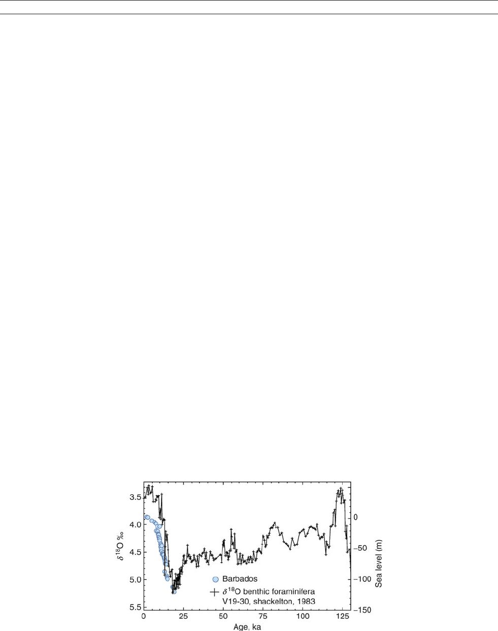
values reflect the effects of temperature and ice-volume (hence
sea level) changes in the shells of single-celled organisms
called foraminifera. By calibrating foraminiferal d
18
O varia-
tions to the reef terrace record, geologists can make an estimate
of global sea-level changes ( Figure S3). However, it is difficult
to extend oxygen isotopic sea-level estimates beyond the past
million years because the temperature history of the planet
prior to this is less well known. In addition, diagenetic altera-
tion potentially overprints Late Cretaceous to early Tertiary
d
18
O values (ca. 100–25 My BP), whereas records older than
100 Myr are typically altered.
Our primary information on sea-level change prior to the
Quaternary ( >2My
BP) is derived from stratigraphic records
of continental inundation. Transgressions have flooded the con-
tinents on roughly 100-Myr timescales (e.g., Sloss, 1963),
reflecting changes in the rates of ocean crust production.
Finer-scale cycles (1–10 Myr) have been attributed either to
sea-level change (Suess, 1885) or to tectonic controls (Sloss,
1963; Stille, 1924; Grabau, 1936). These cycles are observed
in the sediment and rock record with deeper water environ-
ments r e p r e s en ti n g t r an s g r e s s i o n s a n d s h a l l o w e r w a te r
environm en ts representin g regressions.
Studies at Exxon Production Research Company (EPR)
revolutionized our view of the stratigraphic record of sea-level
change. Sea level falls and tectonic changes both produce ero-
sion surfaces termed “unconformities” ; packages of sediments
on continental margins bracketed by unconformities are called
“sequences. ” Researchers at EPR made a revolutionary break-
through in using seismic reflection profiles to identify
sequences and then using these sequences to estimate the ages
and magnitudes of past sea level changes ( Figure S4; Haq et al.,
1987; Vail et al., 1977). These estimates proved highly contro-
versial, in part because of the proprietary nature of the data
used to construct them and in part because of flaws in the
method used to estimate the amplitudes of sea-level change.
Nevertheless, more than a decade of studies, described below,
have been carried out, validating the general number and tim-
ing of eustatic events published by EPR – a landmark achieve-
ment. However, estimation of eustatic amplitudes remains one
of the thorniest problems in geology.
A large mid-Oligocene (ca. 30–32 My
BP) sea level lowering
illustrates problems with estimating amplitudes. Vail et al.
( 1977) initially concluded that this event comprised over
400 m of global sea level lowering, a remarkably large drop.
Geophysical studies showed that the methodology employed
in these estimates did not properly account for the effects of
basin subsidence and water depth and thus grossly overesti-
mated the amplitudes (see summary in Christie-Blick et al.,
1990). A further decade of study by EPR scientists provided
an estimate of 160 m of lowering for this mid-Oligocene
event (Figure S5), an amplitude that still strained credulity.
Stable isotopic studies have long suggested amplitudes closer
to 30–60 m for this event (e.g., Miller et al., 1985, 1998). Rig-
orous studies of borehole transects on the New Jersey margin
yield an estimate for this event of 50 m (Kominz and Pekar,
2001) using a method called backstripping (see below for defi-
nition), and this estimate is probably correct within 10 m.
Despite these recent studies, the amplitude of sea-level change
remains one of the poorest constrained boundary conditions of
the Earth.
Recognizing that it had the unique ability to provide a glo-
bal dataset, the international Ocean Drilling Program (ODP),
operator of the drillship JOIDES Resolution, entered into sea-
level research in the 1990s. ODP identified four major goals
in sea-level research: (a) test the synchrony of sea-level events
in widely separated locations; (b) estimate the amplitude of sea-
level changes; (c) evaluate various models that seek to explain
the stratigraphic response to sea-level oscillations; and (d)
determine the mechanisms that control sea level. To accomplish
these goals, a strategy of drilling transects of boreholes on pas-
sive margins was adopted.
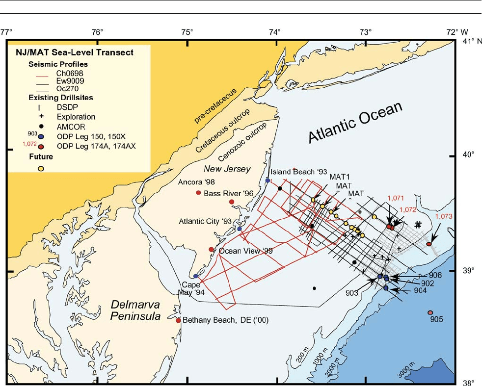
The New Jersey sea level transect
The New Jersey margin was selected by ODP as an ideal
location to begin the investigation of the Late Cretaceous to
Cenozoic history of sea-level change because of its rapid
sedimentation, tectonic stability, good chronostratigraphic
control, and abundant seismic well log and borehole data
(Miller and Mountain, 1994). To evaluate sequences and sea-
level changes, the “New Jersey Sea-Level Transect” was
designed as a series of boreholes from the onshore New Jersey
Coastal Plain across the continental shelf to the slope and
rise (Figure S5). The transect initially focused on the past
34 Myr (Oligocene-Recent; Miller and Mountain, 1996), a
time when large ice sheets waxed and waned, potentially
changing sea level by up to 100 m. More recent studies
Figure S3 Comparison of the global estimate for sea-level derived from Barbados terraces (Fairbanks, 1989) with deep-sea benthic foraminiferal
d
18
O values from Pacific core V19-30 scaled to sea-level assuming 0.11% /10 m of sea-level change (Fairbanks and Matthews, 1978) (Wright, Miller,
Sheridan, unpublished).
880 SEA LEVEL CHANGE, LAST 250 MILLION YEARS
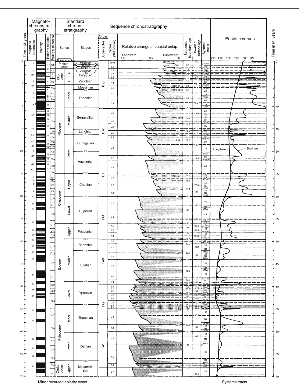
Figure S4 Cenozoic portion of the Haq et al. (1987) sea-level record.
SEA LEVEL CHANGE, LAST 250 MILLION YEARS 881
have extended back to 100 MyBP (Late Cretaceous; Miller
et al., 2003).
Seismic profiles provide a means of imaging strata like a
sonogram images structures within the human body. Seismic
profiles exhibit stratigraphic geometries resulting from erosion,
potentially due to sea-level lowerings (“sequence boundaries”).
The seismic surfaces reveal themselves in borehole sediments
as erosion surfaces. The New Jersey Transect dated these
sequence boundaries by drilling in relatively deep water
(400–1,400 m) on the continental slope and rise and using
various tools for age control (fossils, magnetostratigraphy,
Sr-isotopic stratigraphy). Drilling onshore in New Jersey also
dated these sequences in a more proximal nearshore to
paleo-shelf setting, where time gaps or hiatuses were longer.
Nevertheless, the onshore hiatuses (white gaps between blue
boxes; Figure S6) correlate remarkably well with offshore
sequence boundaries (m1, m2, etc. on Figure S6). This estab-
lishes a regional correlation between these hiatuses and
associated sequence boundaries, and a relation to at least
regional-scale sea-level lowerings.
Comparison of the New Jersey sequence stratigraphic
record with oxygen isotopes provides a link between regional
sea-level lowerings and global changes in ice volume (hence
sea level) for the past 34 Ma (Figure S6). Oxygen isotopic
(d
18
O) increases in deep-sea Atlantic cores correlate with the
sea-level lowerings in New Jersey (Figure S6). This demon-
strates that a significant portion of oxygen isotopic changes
must be attributed to changes in ice volume. Still, we cannot
precisely determine the extent of the role of ice growth versus
cooling of bottom waters on any individual d
18
O increase. For
example, a large d
18
O increase occurred across the Oligocene/
Miocene boundary (ca. 23 Ma), correlating with the m6
continental slope and the O6/Kw0 onshore sequence boundaries
(Figure S6). If this were attributed entirely to ice volume (pre-
sumably from Antarctic ice, because Northern Hemisphere Ice
Sheets did not begin to grow until late Miocene to Pliocene), this
change would be equivalent to a 90 m eustatic sea level drop. It
is likely however, that bottom waters cooled at the same time as
the glaciation; during the Quaternary, about two-third of the d
18
O
signal is controlled by ice volume and one-third by temperature
(Fairbanks, 1989). Applying this rule of thumb to the older
record indicates about 60 m, not 90 m, of eustatic lowering;
however, it is still possible that the temperature effects were lar-
ger and sea level change would have been correspondingly less.
Figure S5 Map showing seismic profiles and boreholes, New Jersey sea-level transect.
882 SEA LEVEL CHANGE, LAST 250 MILLION YEARS
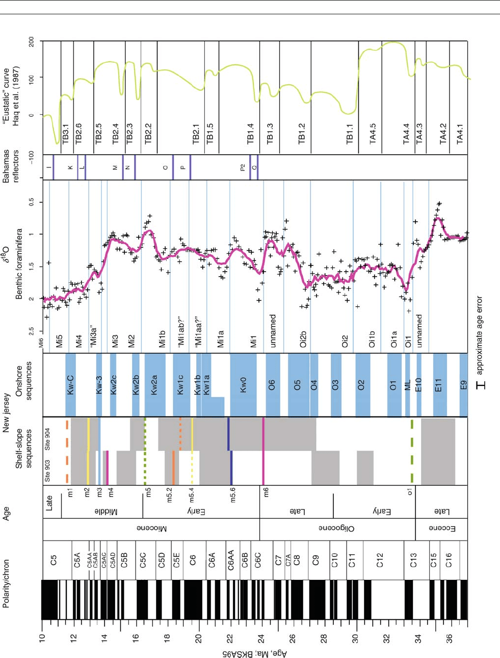
Figure S6 Comparison of offshore New Jersey, onshore New Jersey, global oxygen isotopes, ages of Bahamas reflections, and Haq et al. (1987) sea-level record (Miller et al., 1998).
SEA LEVEL CHANGE, LAST 250 MILLION YEARS 883