Пеллинен Л.П. Высшая геодезия (Теоретическая геодезия)
Подождите немного. Документ загружается.

плановых координат
и
высот квазигеоида
в
астрономо-гёодезической сети.
—
Труды ЦНИИГАиК,
1969, вып. 176, с. 60—67.
24.
Еремеев
В. Ф.,
Юркина
М. Я.
Теория высот
в
гравитационном
поле Земли.
М.,
«Недра»,
1971. 144 с.
25.
Жонголович
И. Д.
Внешнее гравитационное поле Земли
и
фундамен-
тальные постоянные, связанные
с ним. —
Труды Ин-та теоретич. астроно-
мии.
М. — Л.,
Изд-во
АН
СССР,
1952, вып.
III.
126 с.
26.
Жонголович
Я. Д. Об
определении размеров общего земного эллип-
соида.
—
Труды Ин-та теоретич. астрономии.
М. — Л.»
Изд-во
АН
СССР,
1956,
вып.
IV, с. 4—66.
27.
Жонголович
Я. Д.
Потенциал земного притяжения.
— Бюл.
Инст.
теоретич. астрономии,
1957, т.
VI,
№ 8 (81), с. 505—523.
28.
Закатов
Я. С.
Курс высшей геодезии. Сфероидическая геодезия,
теоретическая геодезия
и
основы гравиметрии.
Изд. 3, доп. и
испр.
М.,
«Недра»,
1964. 504 с.
29.
Закатов
Я. С.
Курс высшей геодезии.
Изд. 4,
перераб.
и доп. М.,
«Недра»,
1976. 511 с.
30.
Изотов
А. А,
Новые исходные геодезические даты СССР.
— В кн.:
Сб.
статей ГУГК,
вып.
XVII.
М.,
Геодезиздат,
1948, с. 22—36.
31.
Изотов
А. А,
Форма
и
размеры Земли
по
современным данным.
—
Труды ЦНИИГАиК,
вып. 73, 1960. 204 с.
32.
Изотов
А. А. К
теории определения фигуры
и
размеров Земли
по
наблюдениям искусственных спутников Земли.
— Изв.
вузов. «Геодезия
и аэрофотосъемка»,
1965, вып. 3, с. 3—11.
33.
Изотов
А. А.
Проблемы построения фундаментальной астрономо-
гёодезической сети СССР.
—
«Геодезия
и
картография»,
1976, № 7, с. 17—30.
34.
Изотов
А. А.,
Пеллинен
Л, П.
Исследования земной рефракции
и методов геодезического нивелирования.
—
Труды ЦНИИГАиК,
1955,
вып.
102. 176 с.
35.
Инструкция
по
вычислению нивелировок.
М.,
«Недра»,
1971. 108 с.
36.
Интегральные
уравнения Молоденского
для
теории фигуры Земли.
Уравнения градусных измерений.
—
Труды ЦНИИГАиК,
1972, вып. 198.
232 с.
37.
Использование
искусственных спутников
для
геодезии.
Под ред.
Хенриксен
С,
Манчини
А.,
Човиц
Б. Пер. с
англ.
М.,
«Мир»,
1975.
432 с.
38.
Использование
радиоинтерферометра
со
сверхдлинной базой
при ре-
шении ряда основных проблем астрономии, геодезии
и
геодинамики.
—
Труды
Ин-та теоретич. астрономич.
Л.,
«Наука»,
1977, в. XVI, с. 19—58. Авт.:
И.
Д.
Жонголович,
В. И.
Валяев,
А. А.
Малков,
Т. Б.
Сабанина.
39.
Каула
У. М.
Спутниковая геодезия. Теоретические основы.
Пер.
с англ.
М.,
«Мир»,
1970. 172 с.
40.
Кашин
Л. А.
Основные пути технического прогресса
в
топографо-
геодезическом производстве.
—
«Геодезия
и
картография»,
1969, № 3,
с.
63—72.
41.
Кашин
Л. А. О
постановке изучения современных движений земной
коры геодезическими методами.
— В кн.:
Современные движения земной
коры. Тарту,
1973, № 5, с. 341—346.
42.
Краснорылов
И. И.,
Плахов
Ю. В.
Основы космической геодезии.
М., «Недра»,
1976. 216 с.
43.
Красовский
Ф. Я.
Методы уравнивания государственной первокласс-
ной триангуляции.
—
Труды ГИГК,
Л., 1931, вып. 2. 87 с.
44.
Красовский
Ф. Я.
Методы уравнивания триангуляции
1
класса
в СССР.
—
Труды ГИГК,
1932, вып. 3. М. — Л., с. 17.
45.
Красовский
Ф. Н.
Новые предложения
по
уравниванию астрономо-
гёодезической сети.
—
«Геодезист»,
М., 1937, № 3, с. 1—10.
46.
Красовский
Ф. Я.
Руководство
по
высшей геодезии.
Ч. 2. М.,
Гео-
дезиздат,
1942. 500 с.
47.
Красовский
Ф. Я.
Схема
и
программа государственной триангуля-
ции.
—
«Избранные соч.»,
т. II. М.,
Изд-во геодез.
лит., 1956, с. 39—69.
48.
Куликов
К. А.
Изменяемость широт
и
долгот.
М.,
Физматгиз,
1932.
400 с.
49.
Кутузов
Я. А.
Научные проблемы геодезии
и
картографии.
—
Вестник
АН
СССР,
1972, № 9, с. 37—43.
-50.
Ларин
Д. А.
Вычисление свободного члена условия дирекционных
углов.
—
«Геодезист»,
1936, № 12, с. 34—36.
51.
Ларин
Д. А. К
вопросу
об
уравнивании астрономо-геодезической
сети.
—
«Геодезия
и
картография»,
1964, № 8, с. 3—12.
52. Ле
Пишон
ТТ.,
Франшто
Ж.,
Боннин
Ж. Тектоника плит. Пер.
с англ.
М.,
«Мир»,
1977. 288 с.
53.
Линник
Ю. В.
Метод наименьших квадратов
и
основы теории обра-
ботки наблюдений.
Изд. 2, доп. и
испр.
Л.,
Физматгиз,
1962. 352 с.
54.
Макаренко
Я. Л.,
Зубинский
В. Я.
Исследование точности построе-
ния геодезических сетей геометрическим спутниковым методом.
—
«Геодезия
и картография»,
1976, № 4, с. 61—66.
55.
Манк
У.,
Макдональд
Г.
Вращение Земли.
Пер. с
англ.
М.,
«Мир»,
1964. 384 с.
56.
Матвеенко
Л. Я.,
Кардашев
Я. С,
Шоломницкий
Г. Б. О радиоин-
терферометре
с
большой базой.
— Изв.
вузов. «Радиофизика»,
1965, № 4,
с.
651-654.
57.
Машимов
М. М.
Курс геодезии. Раздел
V.
Уравнивание геодезиче-
ских сетей.
М., 1973, 436 с.
58.
Машимов
М. М.
Геодезические уравнения
в
пространственной топо-
центрической системе координат.
—
Изв. вузов. «Геодезия
и
аэрофотосъемка»,
1976, вып 1, с. 41—49.
59.
Мельхиор
Я.
Физика
и
динамика планет.
Ч. I. Пер. с
франц.
М.,
«Мир»,
1975. 575 с.
60.
Миеаль
Я. К.
Теория совместного определения фигуры
и
размеров
Земли.
—
Науч. записки Львовского политехи, ин-та,
сер.
геодезич. Львов,
1949, № 1, с. 3-66.
61.
Михайлов
А. А.
Курс гравиметрии
и
теории фигуры Земли.
Изд. 2,
перераб.
и доп. М.,
Редбюро ГУГК
при СНК
СССР,
1939. 432 с.
62.
Молоденский
М. С.
Определение фигуры геоида
при
совместном
использовании астрономо-геодезических уклонений отвеса
и
карты аномалий
силы тяжести.
—
Труды ЦНИИГАиК,
1937, вып. 17, с. 9—30.
63.
Молоденский
М. С.
Основные вопросы, связанные
с
выполнением
астрономо-гравиметрического нивелирования
на
большой территории.
—
В
кн.: Сб.
статей ГУГК,
1944, вып. IV, с. 3—11.
64.
Молоденский
М. С.
Основные вопросы геодезической гравиметрии.
—
Труды ЦНИИГАиК,
1945, вып. 42. 106 с.
65.
Молоденский
М. С.
Изучение фигуры Земли геометрическим (астро-
номо-геодезическим) методом.
— В кн.: Сб.
науч.-техн.
и
произв. статей
по геодезии, картографии, топографии, аэросъемке
и
гравиметрии. ГУГК,
1949, вып.
XXVII,
с. 3-11.
66.
Молоденский
М. С. К
постановке астрономо-гравиметрического
нивелирования
в
СССР.
—
Труды ЦНИИГАиК,
1950, вып. 75, с. 3—10.
67.
Молоденский
М. С.
Метод совместной обработки гравиметрических
и геодезических материалов
для
изучения гравитационного поля Земли
и
ее
фигуры.
—
Труды ЦНИИГАиК,
1951, вып. 86, с. 3—10.
68.
Молоденский
М. С.
Современные задачи изучения фигуры Земли.
—
«Геодезия
и
картография»,
1958, № 7, с. 3—5.
69.
Молоденский
М. С,
Еремеев
В. Ф.,
Юркина
М. Я. Методы изучения
внешнего гравитационного поля
и
фигуры Земли.
—
Труды ЦНИИГАиК,
1960,
вып.
131. 251 с.
70.
Молоденский
М. С,
Еремеев
В. Ф.,
Юркина
М. Я. Оценка точности
ряда Стокса
и
некоторые попытки уточнения
его
теории.
—
Труды
ЦНИИГАиК,
1962, вып. 145, с. 3-21.
71.
Молоденский
М. С,
Лозинская
Л. М. Астрономо-гравиметрическое
нивелирование
по 51-й и 55-й
параллели
от
30-го
до
56
:
го меридиана.
—
В
кн.: Сб.
ЦНИИГАиК,
1939, вып. 3, с. 10-26.

72.
МолоЬендкий
Af. С,
МолоденсКий
С. М.,
Парийский
Й. Й. О вой*
можной связи изменений силы тяжести
и
скорости вращения Земли.
— Изв.
АН СССР. «Физика Земли»,
1975, № 6, с. 3—11.
73.
Морозов
В. Я.
Курс сфероидической геодезии.
М.,
«Недра»,
1969.
304 с. <•
74.
Муралев
Я. Г.
Определение координат пунктов астрономо-гёодези-
ческой сети
с
помощью интегральных формул
М. С.
Молоденского.
—
Изв.
вузов. «Геодезия
и
аэрофотосъемка»,
1965, вып. 4, or 85—96.
75.
Муралев
Я. Г.
Уравнивание астрономо-гёодезической сети
с
приме-
нением формул
М. С.
Молоденского.
— Изв.
вузов. «Геодезия
и
аэрофото-
съемка»,
1966, вып. 1, с. 65—78.
76.
Наставление
по
вычислению гравиметрических уклонений отвеса
и высот квазигеоида (второе издание).
М.,
ОНТИ ЦНИИГАиК,
1974.
42 с.
77.
Нейман
Ю. М. К
методике расчета точности вывода аномалий высот
и уклонений отвеса
по
результатам гравиметрических измерений.
—
«Геоде-
зия
и
картография»,
1974, №2, с. 22—29.
78.
О
возможности
уточнения некоторых астрономических параметров
системы Земля
—
Луна методом оптической локации.
—
«Космические иссле-
дования»,
1966. № 3, с. 414—426. Авт.: Ю. Л.
Кокурин,
В. В.
Курбасов,
В.
Ф.
Лобанов
и др.
79.
О
перспективах
использования светолокационных. (лазерных)
на-
блюдений Луны.
—
«Астроном, журнал»,
т. 52, 1975, вып. 2, с. 387—397.
Авт.:
В. К.
Абалакин,
В. Н.
Бойко,
Ю. Л.
Кокурин
и др.
80.
Основы
спутниковой геодезии.
Под ред. А. А.
Изотова.
М.,
«Недра»,
1975. 320 с. '
81.
Остач
О. М. К
методике астрономо-гравиметрического нивелирова-
ния.
—
Реферативный сборник. ЦНИИГАиК,
1970, № 6, с. 28—33.
82.
Остач
О. М. О
влиянии сжатия Земли
на ее
стоксовы постоянные.
—
Труды ЦНИИГАиК,
М., 1971, вып/ 188, с. 3-19.
83.
Остач
О. М.,
Пеллинен
Л. Я.
Влияние эллиптичности Земли
на ее
стоксовы постоянные.
—
Труды ЦНИИГАиК,
1966, вып. 171, с. 63—68.
84.
Пеллинен
Л, Я.
Требования
к
гравиметрической съемке, связанные
с обработкой астрономо-геодезических
и
нивелирных сетей.
—
Труды
ЦНИИГАиК,
1960, вып. 139, с. 3-44.
85.
Пеллинен
Л. Я.
Методика разложения гравитациошгого потенциала
Земли
по
сферическим функциям.
—
Труды ЦНИИГАиК,
1966, вып. 171,
с.
36-81.
86.
Пеллинен
Л. Я. О
вычислении уклонений отвеса
и
высот квази-
геоида
в
горах.
—
Труды ЦНИИГАиК,
1969, вып. 176, с. 99—112.
87.
Пеллинен
Л. Я. О
целесообразных путях совместной обработки
наземной
и
космической триангуляции.
— Бюл.
станций оптич. наблюд.
ИСЗ,
1969, № 55, с. 23—30.
88.
Пеллинен
Л. Я.
Обработка астрономо-геодезических сетей
в
про-
странственных прямоугольных координатах.
—
«Геодезия
и
картография»,
1970, № 10, с. 7-15.
89.
Пеллинен
Л. Я.
Статистический анализ силы тяжести.
— Изв.
вузов. «Геодезия
и
аэрофотосъемка»,
1970, вып. 5, с. 43—50.
90.
Пеллинен
Л. Я.
Вопросы передачи координат
по
рядам триангуля-
ции большого протяжения.
— Изв.
вузов. «Геодезия
и
аэрофотосъемка»,
1972, вып. 4, с. 21—30.
91.
Пеллинен
Л. Я.
Исследование гравитационных полей
и
формы
Земли, других планет
и
Луны
по
наблюдениям космических аппаратов.
—
Итоги науки. Серия «Космические исследования»,. ВИНИТИ
АН
СССР,
М.,
1972. 180 с.
92.
Пеллинен
Л. Я.,
Говорова
Л. А.
Оценка точности астрономо-грави-
метрического нивелирования
в
СССР.
—
Труды ЦНИИГАиК,
1962, вып. 145,
с.
43-59.
93.
Пеллинен
Л. Я.,
Остач
О. М.
Вопросы совместного использования
спутниковых, гравиметрических
и
астрономо-геодезических данных
для
определения фигуры
й
гравитационного поля Землп.
— Ёюл.
набл. искусств,
небесн.
тел, № 15, т. I, М., 1976, с. 26—62.
94.
Пеллинен
Л. Я.,
Остач
О. М.,
Орлова
Е. М.
Некоторые результаты
астрономо-гравиметрического нивелирования
в
СССР.
—
«Геодезия
и
карто-
графия»,
1972, № 6, с. 4—8.
95.
Пранис-Праневич
Я. Ю.
Руководство
по
уравнительным вычисле-
ниям заполняющей триангуляции
II, III и IV
классов.
М.,
Геодезиздат,
1941.' 416 с.
96.
Проворов
К. Л. О
точности сплошных сетей триангуляции.
М.,
Геодезиздат,
1956. 164 с.
97.
Рабинович
Я. Я.
Порядок использования азимутов Лапласа
при
уравнивании астрономо-геодезической сети.
—
Труды ЦНИИГАиК,
1952,
вып.
87, с. 41—61.
98.
Сазонов
А. 3.
Точность элементов астрономо-геодезической сети
СССР.
—
«Геодезия
и
картография»,
1969, № '5, с. 3—5.
99.
Слудский
Ф. Л.
Общая теория фигуры Земли.
М., 1888. 74 с.
100.
Струве
В. Я.
Дуга меридиана (избранные главы).
Щ., Йзд.
геодез.
лит.,
1957. 256 с.
101.
Судаков
С. Г.
Основные геодезические сети.
М.,
«Недра»,
1975.
368 с.
102.
Татевян
А.'Ш. К
вопросу
об
оценке точности астрономо-геодезиче-
ской сети.
—
«Геодезия
и
картография»,
М., 1966, № 12, с. 10—21.
103.
Татевян
А. Ш.
Исследования
о
построении опорной геодезической
сети.
—
Труды ЦНИИГАиК,
М., 1967, вып. 181. 140 с.
104.
Троицкий
В. С,
Алексеев
Я. Л.,
Никонов
В. Я.
Новые возможности
ешения задач астрометрии, геодинамики
и
геодезии методами радиоинтер-
ерометрии
со
сверхдлинной базой.
—
«Успехи
физ.
наук»,
1975, 117, № 2,
с
363-^368.
105.
Уралов
С. С.
Общая теория методов геодезической астрономии.
М., «Недра»,
1973. 271 с.
106.
Файтельсон
А. С,
Юркина
М. Я. О
вековых изменениях силы
тя-
жести
и
современных вертикальных движениях земной коры.
—
«Геодезия
и картография»,
1974, № 7, с. 13—19.
107.
Фундаментальные
постоянные астрономии.
Пер. с
англ.
и
франц.
М., «Мир»,
1967. 382 с.
108.
Шимбирев
Б. Я.
Теория фигуры Земли.
М.,
«Недра»,
1975. 432 с.
109.
Шокин
Я. Ф.
Гравиметрия (приборы
и
методы измерения силы
тяжести).
М.,
Изд-во геодез.
лит., 1960. 316 с.
110.
Юркина
М. Я. О
координатной системе астрономо-геодезической
сети.
—
«Геодезия
и
картография»,
1975, № 6, с. 6—10.
111.
Balmino
G.,
Reigber
С,
Moynot
Я. The
GRIM
2
Earth
gravity field
model. Veroff. Deutsche Geod. Kommis. Bayer.
Akad.
Wiss, 1976, A, N 86,
34 p. .
v
112.
Bursa
M. Satellite altimetry scaling of the
geopotential
model. —
«Bull.
Astron. Inst.
Czechoslovaque»,
1976, 27, N 1, p. 57—60.
113.
Dufour
Я. M. The whole
geodesy
without ellipsoid. —
«Bull.
geo-
desique»,
1968, N 88, p.
125—Д43.
114.
Elmiger
A. Studien uber Berechnung von Lotabweichungen aus
Massen. Interpolation von XiOtabweichungen und Geoidbestimmung in der
Schweiz. Eidgenosse Techn. Hochschule,
Zurich,
1969, 169 S.
115.
Estposito
P. В.,
Wong
S. K. Geodetic gravitational constant deter-
mined from Mariner 9 radio tracking data. Intern. Symp. on
Earth Gravity
Model and Related Problems. Saint-Louis, USA, Aug. 1972. 16 p.
116.
Fischer
/.,
Shirley
Я., Wyatt P. A
geoid
profile in North America
from a combination of
astrogeodetic
and gravimetric data. —
Journ. «Geop-
hys. Research*, Washington, 71, 1966, N 20, p.
4917—4920.
117.
Gaposchkin
E. M. Gravity-field determination using laser observa-
tions. Center for Astrophysics. SAO Prepr. Ser. 1976, No 548. 33 p.
118.
Geodetic
reference system 1967. Publication speciale du Bulletin
geodesique.
— Bureau
Central
de Г
AIG,
1970. 116 p.
119.
Hay
ford
/. The figure of the earth and isostasy from measurements
in
the United States. Washington,
USGGS,
1909. 177 p.
120.
Hayford
J. Supplementary investigation in 1909 of the figure of the
Earth
and isostasy. Washington,
USGGS,
1910. 80 p.
121.
Heiskanen
W. A.,
Moritz
H. Physical
geodesy.
W. H. Freeman.
San.
Francisco,
Calif,
1967. 364 p.
122.
Hotine
M. Mathematical
geodesy.
ESSA
Monograph 2. U. S. Depart-
ment of Commerce. Washington, 1969, p. 416 + XIV.
123.
Hradilek
L. Bestimmung der relativen Lotabweichungen und des
Refraktionkoeffizienten beim Ausgleich trigonometrisch gemessener Hohen-
netze. —
«Studia
geophysica et
geogaetica»,
1958, N 2, 101—121, 1959, N 4,
334-359, 1960, N 3,
217-232
p.
124.
Hradilek
L. Theoretische Begnindung der Methode fur die
Refrak-
tions und Lotabweichungsbestimmung auf jeden Punkte
eines
trigonometris-
chen Hohennetzes. —
«Studia
geophysica et
geodaetica»,
1960, N 1, p. 1—5.
125.
Improvement
in the geopotential derived from satellite and surface
data
(Gem 7 and 8). —
«Journ.
Geophys. Research*, 82, N 5, 1977, pv 901—914.
Abm.:
Wagner C. A.,
Lerch
F. J., Brownd J. E., Richardson J. A.
126.
Jeffreys
H. The determination of the
Earth's
gravitational field.
Mon.
Not. Roy.
Astr.
Soc, Geoph. Suppl., 1941, p. 1—22.
127. Jeffreys H. On the hydrostatic theory of the figure of the
Earth
«Geophys.
J. Roy. Astron.
Soc.»,
1963, 8, № 2, p. 196—202.
128.
Kaula
W. M. Statistical and harmonic analysis of gravity.
Army
Map
Service
Techn.
Rep. N 24, 1959, 101 p. —
«Journ.
Geophys. Research.*,
1959, N 12, p. 2401-2421.
129.
Kaula
W. M. A
geoid
and world
geodetic
system based on a combi-
nation of gravimetric, astrogeodetic and satellite data. —
«Journ.
Geophys.
Research*,
1961, v. 66, N 6, p. 1799-1811.
130.
Khan
M. A. Some geophysical and
geodetic
contributions of satel-
lite-determined gravity results. —
«Geophys.
surv.»,
1976, v. 2, N 4,
p. 469-496.
131.
Marsh
/. G.,
Chang
E. S. Detailed gravimetric
geoid
confirmation
of sea surface topography
detected
by the Skylab S-l93 altimeter in the Atlantic
ocean. —
«Bulletin
geodesique»,
50, N 3, 1976, p. 291—299.
132.
Moritz
H. Least-squares collocation. —
«Ver6ff.
Deutsch.
geod.
Kommis.
Bayer.
Akad.
Wiss.»,
1973, A, N 75, 91 p.
133.
Moritz
H. Special Study Group 5.39. Fundamental
geodetic
con-
stants.
Trav.
de
l'AIG,
t. 25, Rapports generaux et rapports techniques.
XVI
Ass. Gener. Grenoble, Sept. 1975,
Paris,
1976, p. 411—418.
134. New pieces in the picture puzzle of an astrogeodetic
geoid
map of
the world. ^-
«Bulletin
geodesique»,
N 88, 1968,
199—221
c. Abm.:
Fischer
I.,
Slutsky
M., Shirley E. R., Wyatt P. Y.
135.
Niethammer
T. Das astronomische Nivellement in Meridian des
St.
Gotthard. Astronomisch-geodatische Arbeiten in der Schweiz. Schweiz.
Geod.
Kommis, 1939, Band 20,
Bern,
S. 48.
136. On
Reference
Coordinate systems for
Earth
Dynamics. Colloquium
No 26,
26—31
August 1974.
Torun.
Poland. Warszawa, 1975, 478 p.
137.
Proceedings
of Symposium on
Earth's
Gravitational
Field
and Secu-
lar
Variations in Position. Sydney,
Australia,
1974, 727 p.
138.
Proceedings
of the International Symposium on Problems related
to the Redefinition of North American Geodetic Networks
(Canada,
1974). —
«Canadian
Surveyor*, vol. 28, 1974, N 5, p. 435—749.
139.
Rapp
R. H. Analytical and numerical differences
between
two met-
hods for the combination of gravimetric and satellite data. —
«Bollet,
geofis.
teor. ed
appl.»,
1969, N 41—42, p. 108—118.
140.
Rapp
R. Numerical results from the combination of gravimetric
and
satellite data using the principles of least squares collocation. Rp. Depart.
Geod.
Sc. Ohio St. Univ., № 200 1973. 58 p.
141.
Rapp
R. H. Potential coefficient determinations from 5
9
— terre-
strial
gravity data. Rp. Depart. Geod. Sc. Ohio St. Univ No 251, 1977. 77 p.

142.
Simmons
L. G. How accurate is first — order triangulation? —
«Surveying
and mapping*, 11, 1951, No. 4, p. 392—395.
143.
Smith
D. E. et al. Contributions to the National Geodetic Satellite
Program
by Goddard Space Flight Center. —
«Journ.
Geophys. Research*,
81, N 5, 1976, p.
1006—1026.
144.
Vening-Meinesz
F. A. Changes of
deflections
of the plumb-line
brought by a change of the reference ellipsoid. —
«Bulletin geodesique»,
N 15,
1950, p. 43-51.
145.
Wagner
C. A. Zonal gravity harmonics from long satellite arcs by
a
seminumeric method. —
«Journ.
Geophys. Research*, 78, N 17, 1973,
p.
3271—3280.
146.
Yumi
S. Report of the International Polar Motion Service (1973.0—
1975.4). XVI Gener. Assembly
IAG—IUGG,
Grenoble, 1975. 10 p.
147. 1973
Smithsonian
Standard
Earth
v
(III),
SAO Spec. Report N 353,
1974, p. 388.
148. — 2nd
International
Symposium
«Geodesy
and Physics of the
Earth*,
Potsdam, May 7th—11th, 1973, Proceedings. Potsdam, Veroffentlichungen
Zentralinst.
Physik der
Erde,
1974, Nr 30,
Teil
1, 233 S,
Teil
2, 556 s.
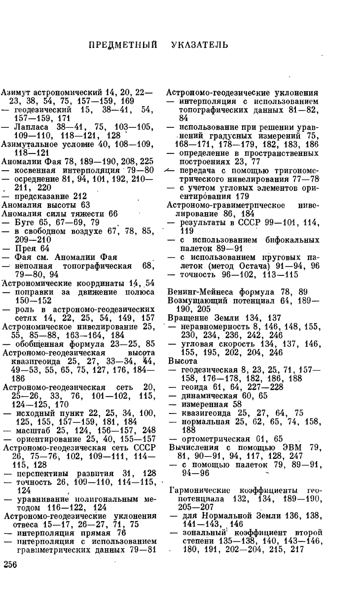
ПРЕДМЕТНЫЙ УКАЗАТЕЛЬ
Азимут астрономический
14, 20, 22—
23,
38, 54, 75, 157-159, 169
— геодезический
15, 38—41, 54,
— Лапласа'38—41,
75, 103—105,
109—110, 118—121, 128 *
Азимутальное условие
40, 108—109,
118-121
Аномалии
Фая 78, 189—190, 208, 225
— косвенная интерполяция
79—80
— осреднение
81, 94, 101, 192, 210—
.
211, 220
— предсказание
212
Аномалия высоты
63
Аномалия силы тяжести
66
— Буге
65, 67-69, 79
—
в
свободном воздухе
67, 78, 85,
209-210
— Прея
64
—
Фая см.
Аномалии
Фая
— неполная топографическая
68,
79-80, 94
Астрономические координаты
14, 54
— поправки
за
движение полюса
150-152
— роль
в
астрономо-геодезических
сетях
14, 22, 25, 54, 149, 157
Астрономическое нивелирование
25,
55,
85-88, 163-164, 184
— обобщенная формула
23—25, 85
Астрономо-геодезическая высота
квазигеоида
25, 27, 33—34, 44,
49-53,
55, 65, 75, 127, 176, 184-
186
Астрономо-геодезическая сеть
20,
25—26, 33, 76, 101—102, 115,
124-125, 170
— исходный пункт
22, 25, 34, 100,
125,
155, 157-159, 181, 184
— масштаб
25, 124, 156-157, 248
— ориентирование
25, 40, 155—157
Астрономо-геодезическая сеть СССР
26,
75-76, 102, 109-111, 114-
115,
128
— перспективы развития
31, 128
— точность
26, 109—110, 114—115,
124
— уравнивание полигональным
ме-
тодом
116—122, 124
Астр ономо-ге о дезические у к л онения
отвеса
15—17, 26—27, 71, 75
— интерполяция прямая
76
— интерполяция
с
использованием
гравиметрических данных
79—81
Астрономо-геодезические уклонения
— интерполяция
с
использованием
топографических данных
81—82,
84
— использование
при
решении урав-
нений градусных измерений
75,
168-171, 178-179, 182, 183, 186
— определение
в
пространственных
построениях
23, 77
^— передача
с
помощью тригономе-
трического нивелирования
77—78
—
с
учетом угловых элементов ори-
ентирования
179
Астрономо-гр авиметрическое ниве-
лирование
86, 184
— результаты
в
СССР
99—101, 114,
119
—
с
использованием бифокальных
палеток
89—91
—
с
использованием круговых
па-
леток (метод Остача)
91—94, 96
— точность
96—102, 113—115
Венинг-Мейнеса формула
78, 89
Возмущающий потенциал
64, 189—
190, 205
Вращение Земли
134, 137
'
—
неравномерность
8, 146, 148, 155,
230, 234, 236, 242, 246
— угловая скорость
134, 137, 146,
155,
195, 202, 204, 246
Высота
— геодезическая
8, 23,
25L,
71, 157—
158,
176-178, 182, 186, 188
— геоида
61, 64, 227—228
— динамическая
60, 65
— измеренная
58
— квазигеоида
25, 27, 64, 75
— нормальная
25, 62, 65, 74, 158,
188
— ортометрическая
61, 65
Вычисления
с
помощью
ЭВМ 79,
81,
90-91, 94, 117, 128, 247
—
с
помощью палеток
79, 89—91,
94-96
Гармонические коэффициенты гео-
потенциала
132, 134, 189—190,
205-207
—
для
Нормальной Земли
136, 138,
141-143, ,146
— зональный
5
коэффициент второй
степени
135—138, 140, 143—146,
*
180, 191, 202-204, 215, 217
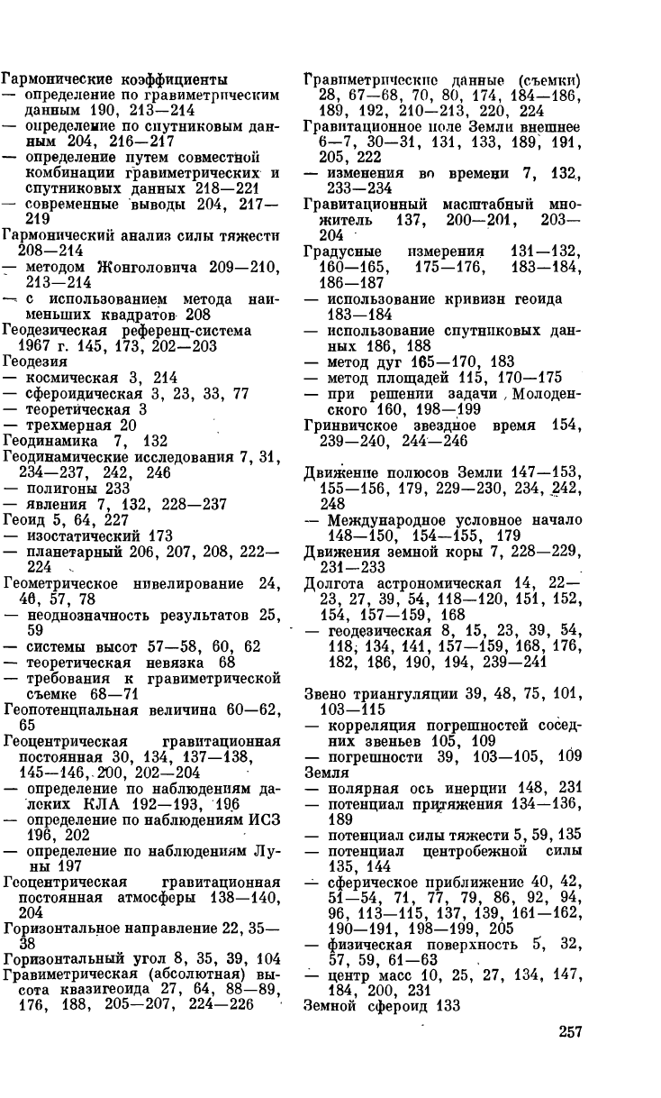
Гармонические коэффициенты
— определение
по
гравиметрическим
данным
190, 213—214
— определение
по
спутниковым дан-
ным
204, 216-217
— определение путем совместной
комбинации гравиметрических
и
спутниковых данных
218—221
— современные выводы
204, 217—
219
Гармонический анализ силы тяжести
208-214
— методом Жонголовича
209—210,
213-214
—-
с
использованием метода наи-
меньших квадратов
208
Геодезическая референц-система
1967 г. 145, 173, 202-203
Геодезия
— космическая
3, 214
— сфероидическая
3, 23, 33, 77
— теоретическая
3
— трехмерная
20
Геодинамика
7, 132
Геодинамические исследования
7, 31,
234—237, 242, 246
— полигоны
233
— явления
7, 132, 228—237
Геоид
5, 64, 227
— изостатический
173
— планетарный
206, 207, 208, 222—
224 .
Геометрическое нивелирование
24,
46,
57, 78
— неоднозначность результатов
25,
59
— системы высот
57—58, 60, 62
— теоретическая невязка
68
— требования
к
гравиметрической
съемке
68—71
Геопотенциальная величина
60—62,
65
Геоцентрическая гравитационная
постоянная
30, 134, 137—138,
145-146,-200, 202-204
— определение
по
наблюдениям
да-
леких
КЛА 192—193, 196
— определение
по
наблюдениям
ИСЗ
196, 202
— определение
по
наблюдениям
Лу-
ны
197
Геоцентрическая гравитационная
постоянная атмосферы
138—140,
204
Горизонтальное направление
22, 35—
38
Горизонтальный угол
8, 35, 39, 104
Гравиметрическая (абсолютная)
вы-
сота квазигеоида
27, 64, 88—89,
176, 188, 205-207, 224—226
Гравиметрические данные (съемки)
28,
67-68, 70, 80, 174, 184-186,
189,
192, 210-213, 220, 224
Гравитационное ноле Земли внешнее
6-7, 30-31, 131, 133, 189, 191,
205,
222
— изменения
во
времени
7, 132,
233-234
Гравитационный масштабный мно-
житель
137, 200—201, 203—
204
Градусные измерения
131—132,
160-165, 175-176, 183-184,
186-187
— использование кривизн геоида
183—184
— использование спутниковых дан-
ных
186, 188
— метод
дуг 165—170, 183
— метод площадей
115, 170—175
—
при
решении задачи
,
Молоден-
ского
160, 198—199
Гринвичское звездное время
154,
239-240, 244-246
Движение полюсов Земли
147—153,
155-156, 179, 229-230, 234, 242,
248
— Международное условное начало
148-150, 154-155, 179
Движения земной коры
7, 228—229,
231-233
Долгота астрономическая
14, 22—
23,
27, 39, 54, 118-120, 151, 152,
154, 157-159, 168
— геодезическая
8, 15, 23, 39, 54,
118,
134, 141, 157-159, 168, 176,
182,
186, 190, 194, 239-241
Звено триангуляции
39, 48, 75, 101,
103-115
— корреляция погрешностей сосед-
них звеньев
105, 109
— погрешности
39, 103—105, 109
Земля
— полярная
ось
инерции
148, 231
— потенциал притяжения
134—136,
189
— потенциал силы тяжести
5, 59,135
— потенциал центробежной силы
135,
144
— сферическое приближение
40, 42,
51-54, 71, 77, 79, 86, 92, 94,
96,
113-115, 137, 139, 161-162,
190-191, 198-199, 205
— физическая поверхность
5, 32,
57,
59, 61-63
— центр масс
10, 25, 27, 134, 147,
184, 200, 231
Земной сфероид
133

Земной эллипсоид
6/162—165, 172—
173
Земные приливы
8, 229—230, 235—
236
Зенит астрономический
13, 15, 35
— геодезический
13, 15, 35
Зенитные расстояния
13, 36, 39,
41,
44-45
— астрономические
13, 41, 71—73,
77
— геодезические
17, 71—73, 77
Изостазия
82, 173, 224
Искусственные спутники Земли
28—
29 215 230
— возмущения
215—216, 228, 230
— геодинамические
235
— наблюдения допплеровские
152,
186
— наблюдения лазерные
28, 235
— наблюдения фотографические
28,
186
— навигационные
29, 152
— определение гравитационного
по-
ля Земли
29, 31, 199—201, 216—
220
— определение координат
28—31,
153,
186-189, 199, 202
— определение фигуры геоида
185,
222-223,
227
Исходные геодезические даты
25,
46,
118, 157—160
—
в
местных геодезических сетях
54
—
в
СССР
159, 175
Квазигеоид
6, 25, 34, 48, 64, 132, 205
— высоты
см.
астрономо-гёодезиче-
ские высоты квазигеоида, гра-
виметрические (абсолютные)
вы-
соты квазигеоида
— детальные исследования
101,
224-228
— общие особенности
222—223
— отличие
от
геоида
64—65
Ковариация
104—106,108,127,
211
—
212
— погрешностей звеньев триангуля-
ции
104—106, 108
ч
Коллокации метод
211—212, 221
Координаты астрономические
14,
22-23,
27, 54, 151, 168
— геодезические
8, 15, 23, 157—159,
176-177, 182, 186
— геоцентрические
10, 134—136,
194-195,
240
— горизонтальные
13—15, 21—23,
50-52,
126-127, 181-182
— прямоугольные
см.
прямоуголь-
ные координаты
— селеноцентрические
238
Кординаты
— сферические
10, 134—136, 189—
190,
195„ 240, 244
— топоцентрические
13—14, 21—23
— цилиндрические
195, 240
— экваториальные
9, 13, 22, 125,
147,
180-182, 186, 244
— эллипсоидальные
8, 10, 141
Корреляции коэффициент
105, 109,
123
Корреляционная матрица погрешно-
стей
123
Литосферные (тектонические) плиты
7, 222, 231-233, 248
Луна, использование
в
геодезии
197,
237-242
Матрица поворота
11, 12, 14, 15,
112,
126, 156, 180-182
Международное бюро времени
152—
155,
156
Метод наименьших квадратов
102,
151,
201, 208
— обобщенный
122—124
Метод проектирования
23, 32/-33,
44-47,
111-114, 119-120, 124—
125,
175-176
Метод развертывания
33, 46—53,
56,
115, 118, 165-166
Методы изучения фигуры
и
внешнего
гравитационного поля Земли
— астрономо-геодезический
8, 26,
30,
75, 160-165, 171-175, 183-
186
— гравиметрический
27, 30, 171—
175,
191-192, 208-214, 219—
221,
224-226
— спутниковый геометрический
28,
30,
186-188, 227-228
— спутниковый динамический
29,
30,
186-188, 201, 214-219
— сравнительная характеристика
30-31
Молоденского теория изучения
фи-
гуры Земли
20, 62, 78, 140, 160,
189,
198-199
Наблюдения далеких космических
летательных аппаратов
30, 192
— уравнения наблюдений
194—195
— определение геоцентрической гра-
витационной постоянной
193,
196
— определение координат
195—196
Направляющие косинусы
10, И, 13,
22,
72, 177, 244
Начало счета долгот
149, 153—156,
179,
237
Начальный меридиан
15, 148

Нормаль
к
эллипсоиду
9, 10, 13,
24,
32, 36-37, 47, 51, 56, 111,
158,
J65-166, 176
Нормальная атмосфера
138—140, 204
Нормальная Земля
17, 131, 132—
134, 145-147, 191, 201, 205
—
в
геофизике
и
геодинамике
133,
134, 203-204
— параметры нулевого порядка
137,
144, 146-147
— параметры порядка сжатия
137,
145,
147
— принципы выбора параметров
134-136, 140
— параметры высших порядков
138,
146
— современные модели
202—204
Нормальная сила тяжести
17, 137,
144-146, 191
Нормальное поле силы тяжести
18,
58,
62
— потенциал
17, 62, 144
— силовые липии
18—20, 62—65
— уровенные поверхности
18—19,
58-59, 62-66
Нормальный потенциал притяжения
136, 141, 189
— представление притяжением двух
неподвижных центров
133
Нуль-пункт нивелирования
6, 54,
58-59
Общеземная система координат
10,
27,
147-149, 156, 176, 187, 237
Общеземной эллипсоид
6, 131—132,
135,
147, 160, 183, 186, 188, 204
Ось вращения Земли
134, 147—150,
184, 239, 240, 244
Ось (полюс) Мира
15, 38—39,, 244
Отвесная линия
13, 15, 24, 33, 35—
36,
47, 49, 56
— вариации направления
во
вре-
мени
7, 234—236 .
Палетка бифокальная
89—91
— круговая Еремеева
79, 94—96
— эллиптическая Молоденского
90
Полигональный метод уравнивания
астрономо-геодезических сетей
102,
115—116
— Боуи
116
—
в
пространственных координатах
124-127
—
в
СССР
116-122, 124
— Гельмерта
115—116, 120
— использование азимутов Лапласа
118-121, 127
— Красовского
117—120
—
с
учетом корреляции ошибок сосед-
них звеньев
121—122,124,126—127
Поправка
за
кривизну силовой
ли-
нии нормального поля силы
тя-
жести
19
—
за
рельеф
68, 78
Поправки Молоденского
за
развер-
тывание
46—53
Потенциал силы тяжести
5, 59, 135
—
на
геоиде
59, 136, 198—201, 203—
204
Пространственные геодезические
по-
строения
20, 21, 45, 56, 71, 75,
101-102, 111-112, 125, 130, 158
Прямоугольные кобрдинаты
—
на
плоскости
55, 90, 107, 120,
122
— пространственные
9—10, 13, 21,
56,
125-126, 156, 176, 186, 245
— преобразования пространствен-
ных
11-12, 14-15, 22, 112,
126, 156, 180-182
Радиоинтерферометры
со
сверхдлин-
ной базой (РСДБ)
30, 242—248
— геодезическое использование
30,
31,
246, 248
— принципы
242—246
— технические средства
243, 245,
247
Редукции горизонтальных направле-
ний
—
за
высоту наблюдаемого пункта
36
—
за
уклонение отвеса
35
Редукции линейных измерений
— базисных
43
— свето-
и
радиодальномерных
41
Редукционная задача геодезии
32
—
при
обработке местных геодези-
ческих сетей
54
— требования
к
точности определе-
ния высот квазигеоида
и
уклоне-
ний отвеса
44
Редукция Буге
64, 67, 81, 138
Референцные системы координат
10,
26,
131, 155-160, 178, 181, 186,
187
Референц-эллипсоид
8, 25, 32—36,
42,
45-48, 53-55, 75, 77, 101,
115,
119-120, 157-159, 164, 165,
170, 173-175, 183
Ряд геодезический (триангуляции)
101,
106-107
— оценка точности
по
невязкам сети
110, 115
— поперечный сдвиг
106, 108, 110,
115
— продольный сдвиг
106—108, 110,
115
— радиальный сдвиг
107, НО, 115
— точность
с
учетом косвенных влия-
ний
53, 102, 111—115
