Source: Eest Rhys, Ed., A Literary and Historical Atlas of Asia
(New York, NY: E.P. Dutton & CO., 1912).
Источник: Эрнест Рис, Эд., Литературно-исторический Атлас Азии (Нью-Йорк, Нью-Йорк: Е. П. Даттон и ко., 1912).
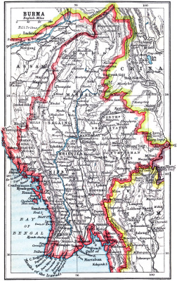
Description: A map from 1912 of Burma (Myanmar), showing the political boundaries of the time, including the frontiers with Siam (Thailand), China, and the British Indian province of Assam. The map shows major cities, railroads, terrain, rivers, the mouths and delta of the Irawadi (Irrawaddy) River, and coastal features of the country as far south as the city of Yey (Yeu).
Описание: Карта Бирмы (Мьянмы) на 1912 год, показаны политические границы, включая границы с Сиамом (Таиланд), Китаем и британской индийской провинцией Ассам. На карте показаны основные города, дороги, рельеф, реки, устья и дельты реки Иравади, и прибрежные особенности страны.
Map Credit: Courtesy the private collection of Roy Winkelman.
Источник: Эрнест Рис, Эд., Литературно-исторический Атлас Азии (Нью-Йорк, Нью-Йорк: Е. П. Даттон и ко., 1912).
Description: A map from 1912 of Burma (Myanmar), showing the political boundaries of the time, including the frontiers with Siam (Thailand), China, and the British Indian province of Assam. The map shows major cities, railroads, terrain, rivers, the mouths and delta of the Irawadi (Irrawaddy) River, and coastal features of the country as far south as the city of Yey (Yeu).
Описание: Карта Бирмы (Мьянмы) на 1912 год, показаны политические границы, включая границы с Сиамом (Таиланд), Китаем и британской индийской провинцией Ассам. На карте показаны основные города, дороги, рельеф, реки, устья и дельты реки Иравади, и прибрежные особенности страны.
Map Credit: Courtesy the private collection of Roy Winkelman.