Абрамова Р.Н., Болсуновская Л.М., Мазуров А.К. Геология рудных месторождений и разведка полезных ископаемых. Часть 2. Геология рудных месторождений. Профессиональный английский язык
Подождите немного. Документ загружается.


WHAT? (content)
¾ Introduction (an expansion \ explanation of the title);
¾ Discussing the characteristic features of the problem ( purpose of the
research);
¾ Methods and materials ( describing method, equipment and conditions
of experiments- how it was conducted);
¾ Results (main findings);
¾ Advantages \ disadvantages (recommendations);
¾ Conclusion (limitations)
******NOT
Any information that is not in the paper;
Abbreviations;
Tables and diagrams;
Citations from other people’s works
HOW?
(structuring)
x Most significant ideas
x Know the main point in a short period of time
HOW?
(effectiveness)
x Descriptive- present tenses ; generalized vocabulary and phrases
x Informative – pas tense; precise specific language, including numbers
What are KEYWORDS
?
x Most important words that are specifically related to the topic (in the
paper)
x Printed at the end of the abstract (in a line)

WORDS FOR WRITING AN ABSTRACT
Means of connection- the sentences within the paragraph can also be linked
with the help of transitional words and phrases (conjunctions \ conjunction
phrases).
ADDITION CONTRAST CONSEQUENCE
and then (thus, now) but hence
furthermore however therefore
in addition nevertheless thus
besides on the one (other) hand as a result
in a similar way on the contrary because
again in contrast with
also ENUMERATION
SUMMARY
firstly \secondly….
CAUSE
in conclusion in the first place
this is the reason for … to conclude lastly
for this reason in brief
EXPLANATION
GENERALIZATION ILLUSTRATION
in respect of (to)
in general for example concerning
as a rule for instance with regard to
on the whole to illustrate that
EXAMPLE:
Linking sentences with the verbs of «acquiring and passing on» knowledge
also serve as boundary –signals between different paragraphs and at the same
time bring them together.
show demonstrate point out introduce
illustrate discuss explain characterize
mention describe concentrate assume

ɗɅȿɆȿɇɌɕ ɉȿɊȿȼɈȾȺ ɋ ȺɇȽɅɂɃɋɄɈȽɈ əɁɕɄȺ
ɇȺ ɊɍɋɋɄɂɃ
1. ɉɊȺȼɂɅɈ ɊəȾȺ
ȿɫɥɢ ɩɨɫɥɟ ɚɪɬɢɤɥɹ (ɢɥɢ ɞɪɭɝɨɝɨ ɨɩɪɟɞɟɥɢɬɟɥɹ ɫɭɳɟɫɬɜɢɬɟɥɶɧɨɝɨ) ɫɬɨɢɬ
ɪɹɞ ɫɥɨɜ (ɱɚɳɟ ɜɫɟɝɨ ɫɭɳɟɫɬɜɢɬɟɥɶɧɵɯ ɜ ɟɞɢɧɨɦ ɱɢɫɥɟ ɢ ɛɟɡ ɩɪɟɞɥɨɝɚ
(ɩɪɟɞɥɨɝɢ ɨɛɵɱɧɨ ɩɪɟɪɵɜɚɸɬ ɪɹɞ), ɬɨ ɬɨɥɶɤɨ ɩɨɫɥɟɞɧɟɟ ɢɡ ɧɢɯ ɛɭɞɟɬ
ɬɟɦ ɫɥɨɜɨɦ, ɤ ɤɨɬɨɪɨɦɭ ɨɬɧɨɫɢɬɶɫɹ ɚɪɬɢɤɥɶ ɢ ɫ ɤɨɬɨɪɨɝɨ ɧɚɞɨ
ɧɚɱɢɧɚɬɶ ɩɟɪɟɜɨɞ ɪɹɞɚ, ɦɵɫɥɟɧɧɨ ɫɬɚɜɹ ɩɨɫɥɟ ɧɟɝɨ ɜɨɩɪɨɫ ɄȺɄɈɃ?
ȼɫɟ ɨɫɬɚɥɶɧɵɟ
ɫɥɨɜɚ ɹɜɥɹɸɬɫɹ ɟɝɨ ɨɩɪɟɞɟɥɟɧɢɹɦɢ.
ɉɪɢ ɩɟɪɟɜɨɞɚ ɪɹɞɚ ɫɜɹɡɶ ɦɟɠɞɭ ɫɥɨɜɚɦɢ ɨɩɪɟɞɟɥɹɟɬɫɹ ɢɡ ɢɯ
ɥɟɤɫɢɱɟɫɤɨɝɨ ɡɧɚɱɟɧɢɹ ɩɪɢ ɷɬɨɦ ɦɨɠɧɨ ɜɜɨɞɢɬɶ ɦɧɨɠ-ɧɨɟ ɱɢɫɥɨ,
ɢɫɩɨɥɶɡɨɜɚɬɶ ɪɚɡɧɵɟ ɩɚɞɟɠɢ \ ɩɪɟɞɥɨɝɢ, ɧɨ ɜ ɜɫɟɯ ɫɥɭɱɚɹɯ ɨɩɪɟɞɟɥɢɦɵɦ
ɫɥɨɜɨɦ ɛɭɞɟɬ ɩɨɫɥɟɞɧɟɟ.
Ɋɹɞ, ɫɨɫɬɨɹɳɢɣ ɬɨɥɶɤɨ ɢɡ 2ɯ ɫɥɨɜ: ɫɭɳɟɫɬɜɢɬɟɥɶɧɨɟ ɢɝɪɚɸɳɟɟ ɪɨɥɶ
ɨɩɪɟɞɟɥɟɧɢɹ, ɥɢɛɨ ɩɟɪɟɜɨɞɢɬɶɫɹ ɩɪɢɥɚɝɚɬɟɥɶɧɵɦ \ ɥɢɛɨ ɩɟɪɟɜɨɞ
ɧɚɱɢɧɚɟɬɫɹ
ɫ ɩɟɪɜɨɝɨ ɫɥɨɜɚ.
Ɋɹɞ ɫɨɫɬɨɢɬ ɢɡ 3ɯ ɫɥɨɜ: ( ɫɪɟɞɧɟɟ ɦɨɠɟɬ ɛɵɬɶ ɩɪɢɥɚɝɚɬɟɥɶɧɵɦ, Participle
I \ II, ɢɥɢ gerund) ɩɟɪɟɜɨɞ ɫɥɟɞɭɟɬ ɧɚɱɢɧɚɬɶ ɫ ɩɨɫɥɟɞɧɟɝɨ ɫɥɨɜɚ ɢ
ɩɪɨɞɨɥɠɚɬɶ ɜ ɫɬɪɨɝɨ ɨɛɪɚɬɧɨɦ ɩɨɪɹɞɤɟ, ɩɪɢɱɟɦ ɩɪɢ ɩɟɪɟɜɨɞɟ ɞɨɥɠɧɚ
ɛɵɬɶ ɫɨɛɥɸɞɟɧɚ ɝɪɚɦɦɚɬɢɱɟɫɤɚɹ ɮɨɪɦɚ ɫɪɟɞɧɟɝɨ ɫɥɨɜɚ.
EXAMPLE: rock-feeding system - ɫɢɫɬɟɦɚ ɩɨɞɚɸɳɚɹ ɝɨɪɧɭɸ ɩɨɪɨɞɭ
ȿɫɥɢ ɜ ɪɹɞɭ ɩɟɪɜɵɦ ɫɬɨɢɬ ɩɪɢɥɚɝɚɬɟɥɶɧɨɟ, ɬɨ ɨɧɨ ɨɛɵɱɧɨ ɨɬɧɨɫɢɬɫɹ
ɤ
ɩɨɫɥɟɞɧɟɦɭ cɥɨɜɭ.
EXAMPLE: the important measurement parameters are presented in
Table 1. – ɗɬɢ ɜɚɠɧɵɟ ɩɚɪɚɦɟɬɪɵ ɢɡɦɟɪɟɧɢɹ ɩɪɟɞɫɬɚɜɥɟɧɵ ɜ ɬɚɛɥɢɰɟ 1.
ɋɨɸɡɵ (and \ or) ɨɛɵɱɧɨ ɧɟ ɩɪɟɪɵɜɚɸɬ ɪɹɞɚ
EXAMPLE: sand and mud carrying waters – ɜɨɞɵ, ɧɟɫɭɳɢɟ ɩɟɫɨɤ ɢ ɢɥ.
ȿɫɥɢ ɦɟɠɞɭ ɞɜɭɦɹ ɫɭɳɟɫɬɜɢɬɟɥɶɧɵɦɢ ɧɟɬ ɩɪɟɞɥɨɝɚ OF
ɬɨ ɜɬɨɪɨɟ ɢɡ ɧɢɯ
ɨɫɧɨɜɧɨɟ,ɨɩɪɟɞɟɥɹɟɦɨɟ ( ɢ ɫ ɧɟɝɨ ɧɚɞɨ ɧɚɱɢɧɚɬɶ ɩɟɪɟɜɨɞ), ɚ ɩɟɪɜɨɟ
ɹɜɥɹɟɬɫɹ ɨɩɪɟɞɟɥɟɧɢɟɦ ɤ ɧɟɦɭ.
2. ɋɌɊȺȾȺɌȿɅɖɇɕɃ ɁȺɅɈȽ
1. ɉɪɢ ɩɟɪɟɜɨɞɟ ɩɪɟɞɥɨɠɟɧɢɣ ɫɨ ɫɤɚɡɭɟɦɵɦ ɜ ɫɬɪɚɞɚɬɟɥɶɧɨɦ ɡɚɥɨɝɟ
ɨɛɵɱɧɨ ɪɟɤɨɦɟɧɞɭɟɬɫɹ ɫɨɯɪɚɧɹɬɶ ɩɨɪɹɞɨɤ ɫɥɨɜ ɚɧɝɥɢɣɫɤɨɝɨ
ɩɪɟɞɥɨɠɟɧɢɹ.
EXAMPLE: These data are presented in Fig. 2 (ɗɬɢ ɞɚɧɧɵɟ ɩɪɟɞɫɬɚɜɥɟɧɵ
\ ɞɚɸɬɫɹ ɧɚ ɪɢɫɸ 2)
2. ɉɪɢ ɩɟɪɟɜɨɞɟ ɚɧɝɥɢɣɫɤɨɝɨ ɫɤɚɡɭɟɦɨɝɨ ɜ ɫɬɪɚɞɚɬɟɥɶɧɨɦ ɡɚɥɨɝɟ ɦɨɠɧɨ
ɢɫɩɨɥɶɡɨɜɚɬɶ ɚɤɬɢɜɧɭɸ ɮɨɪɦɭ ɝɥɚɝɨɥɚ ɜ ɪɭɫɫɤɨɦ ɩɪɟɞɥɨɠɟɧɢɹ. ɉɪɢ
ɷɬɨɦ ɬɚɤɠɟ ɫɨɯɪɚɧɹɟɬɫɹ ɩɨɪɹɞɨɤ ɫɥɨɜ ɚɧɝɥɢɣɫɤɨɝɨ ɩɪɟɞɥɨɠɟɧɢɹ, ɨɞɧɚɤɨ
ɟɝɨ
ɩɨɞɥɟɠɚɳɟɟ ɭɠɟ ɧɟ ɛɭɞɟɬ ɩɨɞɥɟɠɚɳɢɦ ɜ ɪɭɫɫɤɨɦ ɩɟɪɟɜɨɞɟ.
EXAMPLE: The pore spaces must be interconnected ……(ɉɨɪɵ ɞɨɥɠɧɵ
ɛɵɬɶ ɫɨɟɞɢɧɟɧɵ……)
3. ɇɟ ɫɥɟɞɭɟɬ ɡɚɛɵɜɚɬɶ ɨ ɜɨɡɦɨɠɧɨɫɬɢ ɩɟɪɟɜɨɞɚ ɫɤɚɡɭɟɦɨɝɨ ɚɧɝɥɢɣɫɤɨɝɨ
ɩɪɟɞɥɨɠɟɧɢɹ.,ɫɬɨɹɳɟɝɨ ɜ ɩɚɫɫɢɜɧɨɣ ɮɨɪɦɟ, ɪɭɫɫɤɢɦ ɝɥɚɝɨɥɨɦ ɜ
ɫɬɪɚɞɚɬɟɥɶɧɨɦ ɡɚɥɨɝɟ ɫ ɨɤɨɧɱɚɧɢɟɦ – ɫɹ ɢɥɢ – ɫɶ.
EXAMPLE: The advantage of this technique over others was recognized by
mmant scientists. ( ɉɪɟɢɦɭɳɟɫɬɜɨ ɷɬɨɝɨ ɦɟɬɨɞɚ ɩɟɪɟɞ ɞɪɭɝɢɦɢ
ɩɪɢɡɧɚɜɚɥɨɫɶ ɦɧɨɝɢɦɢ ɭɱɟɧɵɦɢ.)
3. ɉɊɂɑȺɋɌɂȿ I \ II
Forms of
participle
Active Passive
Present
participle
(Part I)
Ɏɭɧɤɰɢɹ ɨɩɪɟɞɟɥɟɧɢɹ
ɉɟɪɟɜɨɞ: (ɚ) ɩɪɢɱ. ɧɚɫɬ. ɜɪɟɦɟɧɢ, ɞɟɣɫɬɜ.
Ɂɚɥɨɝ
-ɭɲ, - ɸɳ, -ɚɳ, -ɹɳ
(ɫɩɪɚɲɢɜɚɸɳɢɣ)
(ɛ) ɩɪɢɞɚɬ. ɨɩɪɟɞ. ɩɪɟɞɥɨɠ.
Ɏɭɧɤɰɢɹ ɨɛɫɬɨɹɬɟɥɶɫɬɜɚ
ɉɟɪɟɜɨɞ:
(ɚ) ɞɟɟɩɪ. ɧɚɫɬ. ɜɪɟɦɟɧɢ, ɚ-, ɹ – (ɫɩɪɚɲɢɜɚɹ)
(ɛ) when, while
i. ɫɩɪɚɲɢɜɚɹ
ii. «ɩɪɢ» + ɫɭɳ. (ɩɪɢ ɨɩɪɨɫɟ)
iii. ɩɪɢɞ. ɨɛɫɬɨɹɬ. ɩɪɟɞ.
Ɏɭɧɤɰɢɹ
ɨɩɪɟɞɟɥɟɧɢɹ
ɉɟɪɟɜɨɞ: (ɚ)
ɩɪɢɞɚɬɨɱɧɨɟ ɨɩɪɟɞ.
ɩɪɟɞɥɨɠ.
(ɛ) ɩɪɢɞɚɬ.ɧɚɫɬ. ɢ
ɩɪɨɲ. ɜɪɟɦɟɧɢ
-ɟɦɵɣ, - ɢɦɵɣ
Ɏɭɧɤɰɢɹ
ɨɛɫɬɨɹɬɟɥɶɫɬɜɚ
ɉɟɪɟɜɨɞ:
1.ɞɟɟɩɪɢɱɚɫɬ. ɧɚɫɬ.
ɢɥɢ ɩɪɨɲ. ɜɪɟɦ.
(ɛɭɞɭɱɢ
ɫɩɪɨɲɟɧɧɵɦ)
2. ɩɪɢɞɚɬɨɱ. ɨɛɫɬɨɹɬ.
ɩɪɟɞɥɨɠ.
(ɤɨɝɞɚ ɟɝɨ ɫɩɪɨɫɢɥɢ)
Past
Participle
(Part. II)
Ɏɭɧɤɰɢɹ
ɨɩɪɟɞɟɥɟɧɢɹ
ɉɟɪɟɜɨɞ:
ɉɪɢɱɚɫɬɢɟɦ ɩɪɨɲ.
ɜɪ.
ɫɬɪɚɞɚɬ. ɡɚɥɨɝɚ
ɫɭɮɮɢɤɫɵ –
ɇ-; -Ɇ-
«ɫɩɪɨɲɟɧɧɵɣ»
«ɫɩɪɚɲɢɜɚɟɦɵɣ»
Ɏɭɧɤɰɢɹ
ɨɛɫɬɨɹɬɟɥɶɫɬɜɚ
when, as, if
ɉɟɪɟɜɨɞ:
(ɚ) ɩɪɢɞɚɬ.
ɨɛɫɬɨɹɬ.ɩɪɟɞɥɨɠ.
(ɛ) «ɩɪɢ» + ɫɭɳ.
Perfect
Participle
Ɍɨɥɶɤɨ ɮɭɧɤɰɢɹ ɨɛɫɬɨɹɬɟɥɶɫɬɜɚ
Having asked
ɉɟɪɟɜɨɞ:
(1) ɞɟɟɩɪɢɱ. ɩɪɨɲɟɞ.
ɜɪɟɦɟɧɢ «ɫɩɪɨɫɢ»
(2)
̛̪̬̔. ̨̭̯̍. ̨̛̪̬̖̣̙̖̦̖̥̔
Ɍɨɥɶɤɨ ɮɭɧɤɰɢɹ
ɨɛɫɬɨɹɬɟɥɶɫɬɜɚ
Having been asked
ɩɨɫɥɟ ɬɨɝɨ ɤɚɤ ɟɝɨ
ɫɩɪɨɫɢɥɢ
Having been heated
ɧɚɝɪɟɜɲɢɫɶ
Asking
Being asked
Asked
x Organic residue carried by waters eventually settled to the bottom of
the ancient seas ( Ɉɪɝɚɧɢɱɟɫɤɢɟ ɨɫɚɞɤɢ,ɭɧɨɫɢɦɵɟ ɜɨɞɚɦɢ, ɜ
ɤɨɧɟɱɧɨɦ ɫɱɟɬɟ, ɨɫɟɞɚɥɢ ɧɚ ɞɧɟ ɞɪɟɜɧɢɯ ɦɨɪɟɣ.)
x Most water associated with hydrocarbon reservoirs is salt water.
(Ȼɨɥɶɲɚɹ ɱɚɫɬɶ ɜɨɞɵ ɜ ɤɨɥɥɟɤɬɨɪɚɯ ɭɝɥɟɜɨɞɨɪɨɞɨɜ ɹɜɥɹɟɬɫɹ
ɫɨɥɟɧɨɣ ɜɨɞɨɣ.)
x Where the formation containing an oil reservoir is fairly uniformly
porous and continuous….. (ȼ ɫɥɭɱɚɟ, ɤɨɝɞɚ ɩɥɚɫɬ, ɫɨɞɟɪɠɚɳɢɣ
ɧɟɮɬɟɧɨɫɧɵɣ ɤɨɥɥɟɤɬɨɪ, ɞɨɫɬɚɬɨɱɧɨ ɨɞɧɨɪɨɞɧɨ-ɩɨɪɢɫɬɵɣ.)
4. ɇȿɈɉɊȿȾȿɅȿɇɇȺə ɎɈɊɆȺ ȽɅȺȽɈɅȺ (ɂɇɎɂɇɂɌɂȼ)
1. ȼ ɪɨɥɢ ɩɨɞɥɟɠɚɳɟɝɨ ɢɧɮɢɧɢɬɢɜ ɫɬɨɢɬ ɜ ɧɚɱɚɥɟ
ɩɪɟɞɥɨɠɟɧɢɹ,
ɩɟɪɟɞ
ɫɤɚɡɭɟɦɵɦ, ɢ ɦɨɠɟɬ ɩɟɪɟɜɨɞɢɬɶɫɹ ɢɥɢ ɧɟɨɩɪɟɞɟɥɟɧɧɨɣ ɮɨɪɦɨɣ ɝɥɚɝɨɥɚ,
ɢɥɢ ɫɭɳɟɫɬɜɢɬɟɥɶɧɵɦ.
EXAMPLE: To account for these variations is in principle straightforward.
(Ɉɛɴɹɫɧɟɧɢɟ ɷɬɢɯ ɢɡɦɟɧɟɧɢɣ ɜ ɩɪɢɧɰɢɩɟ ɹɜɥɹɟɬɫɹ ɩɪɨɫɬɵɦ.)
2. ȼ ɪɨɥɢ ɞɨɩɨɥɧɟɧɢɹ ɢɧɮɢɧɢɬɢɜ ɫɬɨɢɬ ɩɨɫɥɟ ɫɤɚɡɭɟɦɨɝɨ ɢ
ɩɟɪɟɜɨɞɢɬɶɫɹ ɧɚ ɪɭɫɫɤɢɣ ɹɡɵɤ ɧɟɨɩɪɟɞɟɥɟɧɧɨɣ ɮɨɪɦɨɣ ɝɥɚɝɨɥɚ.
EXAMPLE: We try to minimize the old disadvantages. (Ɇɵ ɫɬɚɪɚɟɦɫɹ
ɫɜɟɫɬɢ ɤ ɦɢɧɢɦɭɦɭ ɪɚɧɟɟ ɢɦɟɜɲɢɟ ɦɟɫɬɨ ɧɟɞɨɫɬɚɬɤɢ.)
3. ȼ ɪɨɥɢ ɨɛɫɬɨɹɬɟɥɶɫɬɜɚ
ɢɧɮɢɧɢɬɢɜ ɦɨɠɟɬ
ɫɬɨɹɬɶ ɜ ɧɚɱɚɥɟ ɢ ɜ ɤɨɧɰɟ
ɩɪɟɞɥɨɠɟɧɢɹ, ɢ ɜ ɨɛɨɢɯ ɫɥɭɱɚɹɯ ɟɝɨ ɫɥɟɞɭɟɬ ɩɟɪɟɜɨɞɢɬɶ
ɧɟɨɩɪɟɞɟɥɟɧɧɨɣ ɮɨɪɦɨɣ ɝɥɚɝɨɥɚ ɫ ɫɨɸɡɚɦɢ ɞɥɹ ɬɨɝɨ ɱɬɨɛɵ ɢɥɢ ɱɬɨɛɵ.
EXAMPLE: The postulates should be simple enough to seem almost
obvious. (ɉɨɫɬɭɥɚɬɵ ɞɨɥɠɧɵ ɛɵɬɶ ɞɨɫɬɚɬɨɱɧɨ ɩɪɨɫɬɵɦɢ, ɱɬɨɛɵ ɤɚɡɚɬɶɫɹ
ɩɨɱɬɢ ɨɱɟɜɢɞɢɦɵɦ.)
4. ȼ ɪɨɥɢ ɨɩɪɟɞɟɥɟɧɢɹ ɢɧɮɢɧɢɬɢɜɨɛɵɱɧɨ ɫɬɨɢɬ ɩɨɫɥɟ ɨɩɪɟɞɟɥɹɟɦɨɝɨ
ɫɥɨɜɚ ɢ ɨɛɹɡɚɬɟɥɶɧɨ ɩɟɪɟɜɨɞɢɬɶɫɹ ɩɪɢɞɚɬɨɱɧɵɦ ɩɪɟɞɥɨɠɟɧɢɟɦ,
ɜɜɨɞɢɦɵɦ
ɫɨɸɡɨɦ ɤɨɬɨɪɵɣ
.
EXAMPLE: The curves to be presented in Part V were obtained on single-
crystal samples. (Ʉɪɢɜɵɟ, ɤɨɬɨɪɵɟ ɛɭɞɭɬ ɩɪɟɞɫɬɚɜɥɟɧɵ ɜ ɱɚɫɬɢ V, ɛɵɥɢ
ɩɨɥɭɱɟɧɵ ɧɚ ɨɛɪɚɡɰɚɯ ɦɨɧɨɤɪɢɫɚɥɥɨɜ.)
5. ȼ ɪɨɥɢ ɜɜɨɞɧɨɝɨ ɫɥɨɜɚ ɢɧɮɢɧɢɬɢɜɨɛɵɱɧɨ ɫɬɨɢɬ ɜ ɧɚɱɚɥɟ
ɩɪɟɞɥɨɠɟɧɢɹ, ɜɫɟɝɞɚ ɜɵɞɟɥɹɟɬɫɹ ɡɚɩɹɬɵɦɢ ɢ ɦɨɠɟɬ ɩɟɪɟɜɨɞɢɬɶɫɹ ɢɥɢ
ɞɟɟɩɪɢɱɚɫɬɢɟɦ, ɢɥɢ ɧɟɨɩɪɟɞɟɥɟɧɧɨɣ ɮɨɪɦɨɣ ɝɥɚɝɨɥɚ.
EXAMPLE: To be sure, all solutions to problems are conditional.
(Ɉɱɟɜɢɞɧɨ/ ɛɟɡɭɫɥɨɜɧɨ, ɜɫɟ ɪɟɲɟɧɢɹ ɩɪɨɛɥɟɦ ɹɜɥɹɸɬɫɹ ɭɫɥɨɜɧɵɦɢ.)
5. ȽȿɊɍɇȾɂɃ
1.ȼ ɪɨɥɢ ɩɨɞɥɟɠɚɳɟɝɨ ɝɟɪɭɧɞɢɣ ɫɬɨɢɬ ɩɟɪɟɞ ɫɤɚɡɭɟɦɵɦ ɢ ɦɨɠɟɬ
ɩɟɪɟɜɨɞɢɬɶɫɹ ɤɚɤɚ ɫɭɳɟɫɬɜɢɬɟɥɶɧɵɦ, ɬɚɤ ɢ ɢɧɮɢɧɢɬɢɜɨɦ.
EXAMPLE: Defining problems precisely requires patience. (Ɍɨɱɧɨɟ
ɨɩɪɟɞɟɥɟɧɢɟ ɡɚɞɚɱ ɬɪɟɛɭɟɬ ɬɟɪɩɟɧɢɹ.)
2. ȼ ɪɨɥɢ ɨɩɪɟɞɟɥɟɧɢɹ ɝɟɪɭɧɞɢɣ ɫɬɨɹɬɶ ɩɟɪɟɞ ɨɩɪɟɞɟɥɹɟɦɵɦ ɫɥɨɜɨɦ ɛɟɡ
ɩɪɟɞɥɨɝɚ ɢ ɩɨɫɥɟ ɨɩɪɟɞɟɥɹɟɦɨɝɨ ɫɥɨɜɚ ɫ ɩɪɟɞɥɨɝɨɦ of ɢɥɢ
for ɢ
ɩɟɪɟɜɨɞɢɬɫɹ ɫɭɳɟɫɬɜɢɬɟɥɶɧɵɦ \ ɩɪɢɥɚɝɚɬɟɥɶɧɵɦ.
EXAMPLE: the melting point (the point of melting) – ɬɨɱɤɚ ɩɥɚɜɥɟɧɢɹ
3. ȼ ɪɨɥɢ ɨɛɫɬɨɹɬɟɥɶɫɬɜɚ ɝɟɪɭɧɞɢɣ ɜɫɟɝɞɚ ɢɦɟɟɬ ɩɪɟɞɥɨɝ ɢ ɢɧɨɝɞɚ
ɦɨɠɟɬ ɩɟɪɟɜɨɞɢɬɶɫɹ ɞɟɟɩɪɢɱɚɫɬɢɟɦ.
4. ȼ ɪɨɥɢ ɞɨɩɨɥɧɟɧɢɹ ɝɟɪɭɧɞɢɣ ɫɬɨɢɬ ɩɨɫɥɟ ɫɤɚɡɭɟɦɨɝɨ ɢ ɦɨɠɟɬ
ɩɟɪɟɜɨɞɢɬɶɫɹ ɤɚɤɚ ɫɭɳɟɫɬɜɢɬɟɥɶɧɵɦ, ɬɚɤ ɢ ɢɧɮɢɧɢɬɢɜɨɦ, ɢɥɢ
ɫɤɚɡɭɟɦɵɦ ɜ ɩɪɢɞɚɬɨɱɧɨɦ ɩɪɟɞɥɨɠɟɧɢɢ.
EXAMPLE: The turbulent flow of gases produces coolong. (Ɍɭɪɛɭɞɟɧɬɧɨɟ
ɬɟɱɟɧɢɟ ɝɚɡɨɜ ɜɵɡɵɜɚɟɬ ɨɯɥɚɠɞɟɧɢɟ.)
SUPPLEMENTARY READING
(1) Geological maps
Maps Types of maps
Maps are one of the most important
media used to communicate
information in exploration geology.
Maps are a two dimensional
representation of the surface of the
earth and its features. Maps have two
main purposes: 1) to convey detailed
information about a specific area, and
2) to indicate the position of the
specific area relative to other parts of
the earth. The first is accomplished
by recording information in graphic
form. The second is accomplished by
showing reference marks (or a
coordinate system), or by showing a
small scale location map with well
known landmarks. A coordinate
system is nothing more than a
graphical means of locating any point
on the map, with two coordinates for
each point giving positions with
respect to the X axis and Y axis.
Most maps have more than just a map
area, they often have lots of other
information that is given in the space
around the main map area. A
complete map generally has several
main components. In addition to the
main map area, a complete map will
usually include the following
information in various positions
adjacent to the main map area: 1)
title, 2) author (s), 3) date, 4) scale, 5)
indication of true and magnetic north,
and 5) coordinates or reference
points, 5) explanation (code for
Many types of maps are used in
exploration geology. Topographic
maps are the most widely used maps.
These depict the surface morphology
by showing lines of equal elevation
(or contour lines). The most basic
and essential type of map used by
geologists is the geologic map. A
geologic map shows rock types (or
lithologies) and their geometry.
Geologic maps are very often
constructed on a topographic base
map.
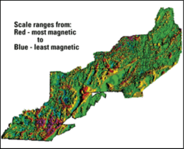
Fig. 2. Geophysical Map
Other types of maps which are used
in conjunction with geologic maps:
(1) geophysical maps show readings
of magnetism, gravity, electrical
conductivity, radioactivity, or other
physical properties of rocks in an
area;
(2) geochemical maps show
geochemical values of samples
reading the map - the colors, symbols
and all other abbreviations used on
the map).
collected in an area. These may be
samples of soil, rock, stream
sediments or water;
(3) derivative maps summarize the
information (numerous values or
readings from an area) or depict the
data that it can be more quickly
evaluated. Typically this is done by
designing a map which delineates or
emphasizes the anomalous (outside
normal) readings or values:
x topographic map - highlights
anomalous values
x thematic map - uses colors or
symbols to code the values on
the map.
(adapted from
http://www.nature.nps.gov\GEOLOGY )
1. Try to explain the following words. Then scan the text «Maps» and see
whether your explanations are correct. State the words or phrases that help
you to understand the words below.
dimensional representation component
feature(s) scale
graphic form explanation
reference mark true north
landmark abbreviation
2. Read the first section and answer these questions.
1. What are maps?
2. What do maps represent?
3. What are the two basic objectives of a map?
4. How is the first objective achieved?
5. How is the second objective achieved?
6. What is the synonym for «reference mark»?
7. What is a coordinate system?
8. What are the two coordinates?
9. What are the major components of a map?
10. What is an explanation?
3. Read the second section of the text «Types of maps» and complete the
sentences.
1. The most widely used maps are a. geochemical values of samples
collected in an area.
2. Topographic maps depict b. readings of magnetism, gravity,
electrical conductivity, radioactivity,
or other physical properties of rocks
in an area.
3. A geologic map shows c. the information.
4. Geologic maps are constructed
d. topographic map and thematic
map.
5. Geophysical maps show
e. the surface morphology by contour
lines.
6. Geochemical maps show f. topographic maps.
7. Derivative maps summarize g. rock types and their geometry.
8. Two types of derivative maps are h. anomalous values.
9. Topographic maps highlight i. the values on the map by using
colors and symbols.
10. Thematic maps code j. on a topographic base map.