Ekundayo E.O. Environmental monitoring
Подождите немного. Документ загружается.

Monitoring Lake Ecosystems Using Integrated Remote
Sensing / Gis Techniques: An Assessment in the Region of West Macedonia, Greece
191
Various ratios of the Landsat bands have been calculated as these are related to SDT
measurements. The TM3/TM1 ratio has been tested because previous investigators found it
to be a strong predictor of SDT (Cox et al., 1998; Lathrop, 1992), but this was not confirmed
by our analysis. All results have been stored to the raster database. Conversion of raster to
vector of the lake water surfaces gave the opportunity to identify and store in the database
the spatial variability of quantity / quality data of the lakes. GIS techniques have been used
to overlay the results obtained from the multi temporal analysis, Figure 14.
Fig. 6. Extracted surfaces of Macro Prespa lake, using the available map coastline.
High resolution of about 0.5 m ortho-photos available through the WMS service of Greek
Cadastral Agency of Greece have been also used to acquire information and verify the
results obtained from the analysis of Landsat data. The GIS system gives the opportunity of
using the ortho-photos as a background while overlaying any type of GIS data and updating
the information. All processing techniques have been applied using the TNTmips Image
Processing / GIS S/W system (www.microimages.com ). Our case study is intended to give
a recent example of the practical applications of RS and GIS to lake monitoring. The RS
study is placed first, followed by the GIS study, and finally an integrated interpretation is
attempted.
5. Information gathering from remote sensing
Lake physics plays a fundamental role in limnology as temperature structures, circulation
patterns and turbulent mixing, all set the environment in which the biology and chemistry
within a lake operate. It is also through physics that the initial impact of any changes in
climate will be felt within a lake.
5.1 Lakes
5.1.1 Lake inventory
Delineation of water bodies is essential for the estimation of the water balance of the area.
Water authorities need to know date, location, extent and variations of these water bodies.
The test area covers a broad region while the transnational Prespa lakes basin is included.
The problems that are faced are related to:
The fact that maps are not readily available
There is lack of updated information
Digital data are in different scales or coordinate systems
Accurate measurements of surface areas of Macro – Micro Prespa lakes are lacking.
The 17
th
of January 2011 Landsat image has been used to make an inventory of all the lakes of
the region at a scale of ~ 1:50000, Figure 3. The lake water surfaces have been extracted using
classification of infrared bands & conversion of raster to vector techniques. There is up to
date information which is readily available in a digital format for the whole of the translational
Environmental Monitoring
192
region. Extraction of surface areas / perimeter and spatial context of the location of the
lakes is easily obtained. Relationships of the different lake water bodies are also
obtained, Figure 7. Accurate mapping of surfaces of the Greek lakes in scales up to ~5000
(Figure 8) is obtained using the WMS - Web service of the Hellenic Cadastre,
http://gis.ktimanet.gr/wms/ktbasemap/default.aspx . The acquisition dates of the aerial
photography are in the time period of 2007 to 2009.
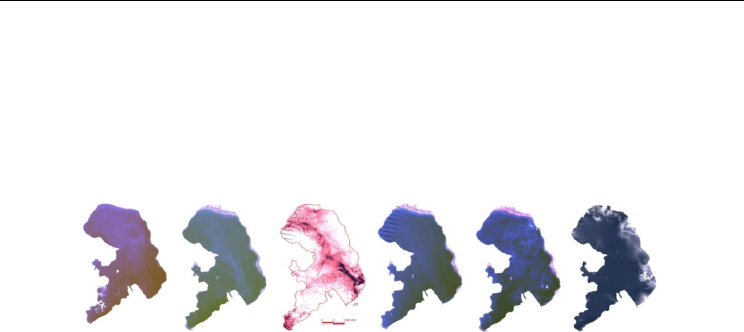
Fig. 7. Lake inventory from the 17
th
January 2011 image scene. Polygons of the water surface
of the lakes have been extracted using classification techniques: A. Ohrid lake B. Macro /
Micro Prespa lakes C. Vegoritis / Petron Lake D. kastoria Lake E. Chimaditis / Zazari lakes
A B
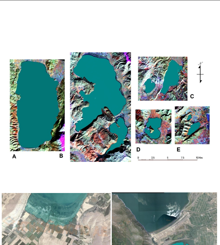
Fig. 8. Overlay of the coastlines extracted from the 17
th
January 2011 image to the
orthophoto of 0.5 m resolution A. south part of Vegoritis lake B. South part of Macro Prespa
lake.
5.1.2 Multitemporal analysis of change in surface area / size / shape of lakes
Lakes are sensitive to both climate change and to anthropogenic influence. Drop of water
level has been observed in both Macro Prespa and Vegoritis lakes, Figure 2. Time series
water level data are available for both lakes even though these measurements are not
comparable for Macro Prespa lake as different reference levels are used between the three
Monitoring Lake Ecosystems Using Integrated Remote
Sensing / Gis Techniques: An Assessment in the Region of West Macedonia, Greece
193
countries. Water level also does not show the spatial variability of the water surfaces, as
changes depend on the bathymetry, the amount of sediment input due to erosion or other
factors like geomorphology / geology. Satellite and especially Landsat data can be used to
perform multi-temporal studies of lake surfaces.
Data collection included the acquisition of lake coastlines as these are available by the
national / local authorities or on the Web. The only readily available data for Vegoritis lake
are those of maps provided by the Greek Geographic Service of the Army of 1970s while the
boundary of Macro Prespa lake has been made available for a time period on the Web
(Traborema EU project). The stored in the GIS database map coastlines have been used to
assess changes in water surfaces. These coastlines have the same areal extend as these
extracted from the Landsat MSS images of the 1974 and therefore are used as a reference.
These lake surfaces / coastlines dated since the 70’s have been compared to the ones
extracted from the multi-temporal Landsat images and stored as GIS vector layers.
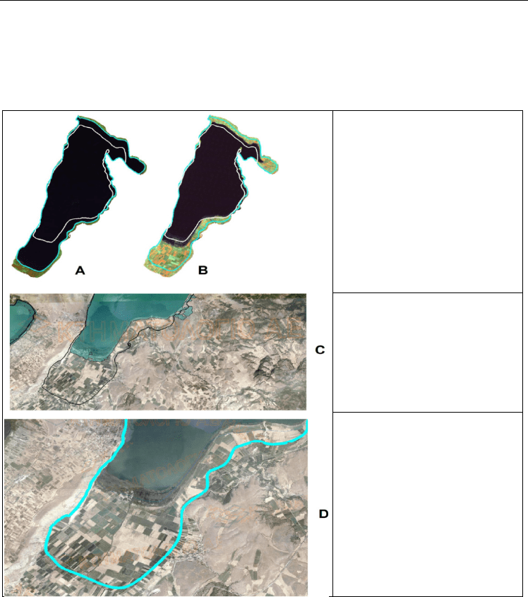
Fig. 9. Incremental changes of Macro Prespa lake for the last ~ 30 years: Changes in the
North (A), South East ( B)and South West (C)
Both Vegoritis and Macro Prespa lakes have lost their water surface area. A reduction of the
surface area of Macro Prespa lake is evident, as estimates of its surface are as following:
20 November 1974 - ~276.5 km², August 1988 ~ 273.7 km², August 2000~265.2 km²,
21 August 2008 ~257.2 km² and 17 January 2011~ 256.7 km². Macro Prespa lake has lost
nearly 19.8 km² of its surface in the period 1973 to 2011.
Sharp drop of water level of Macro Prespa lake occured in 1975/1977 (1.2 m), 1987 /1990
(3.7m) and 2000/2002 (2.2m.) Figure 9. It is further evident that Macro Prespa lake is still
losing its surface, even though the entire Prespa basin has been declared as a trans-
boundary protected area, with the establishment of the “Prespa Park” by the Prime
Ministers of Albania, Greece and the FYR of Macedonia on 2 February 2000.
Vegoritis lake has lost 30% of its surface (1970: 59.7 km² – 2011: 43.8 km²) in the last ~ 30
years. Changes on its coastline are observed in its southern part, Figure 10. This can be
partly explained by its bathymetry as the waters are shallow in the southern part, while its
deepest area is in its western part, Figure 5. Comparison with the multitemporal analysis of
the other lakes of the area shows that Ohrid, Micro Prespa and Petron lakes have lost only a
Environmental Monitoring
194
small part of their surface area. Analysis of the space imagery of the years 1975 and 2011
respectively clearly revealed areas of shore line changes. It is now possible to draw accurate
maps which look at the future incremental changes of Vegoritis / Prespa lakes. The
modeling of this process is efficiently performed in the GIS.
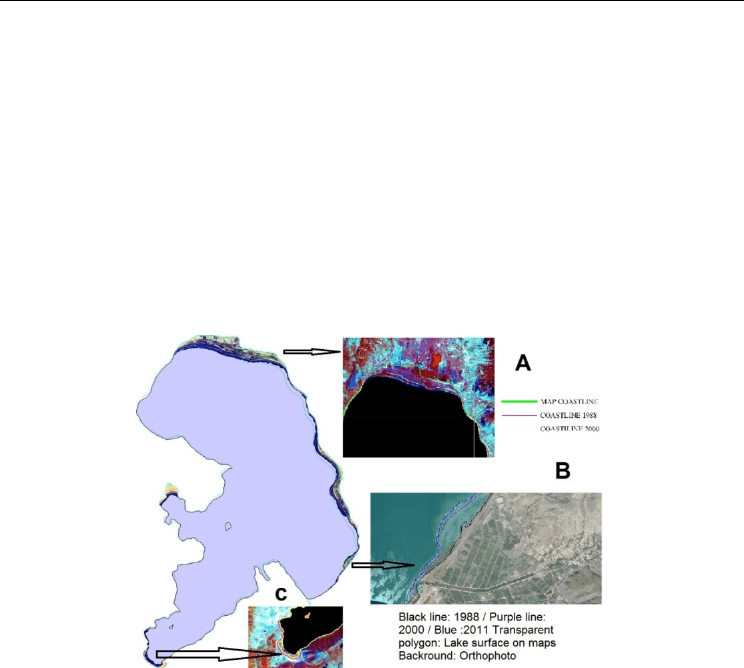
A. & B.
The coastlines of 1988 (blue line)
as well as that of 2011 (white
line) have been plotted on the
Landsat 1984 image scene.
C.
South part of Vegoritis lake: The
black line shows the coastline of
the map. The transparent
polygon of the lake surface has
been outlined from the17th
January 2011 Landsat image.
D.
The 1988 coastline plotted on the
orthophoto: Estimates of the
land use change of the lake to
a
g
ricultural land can be obtained
and used by authorities.
Fig. 10. Changes of the Vegoritis lake surface area.
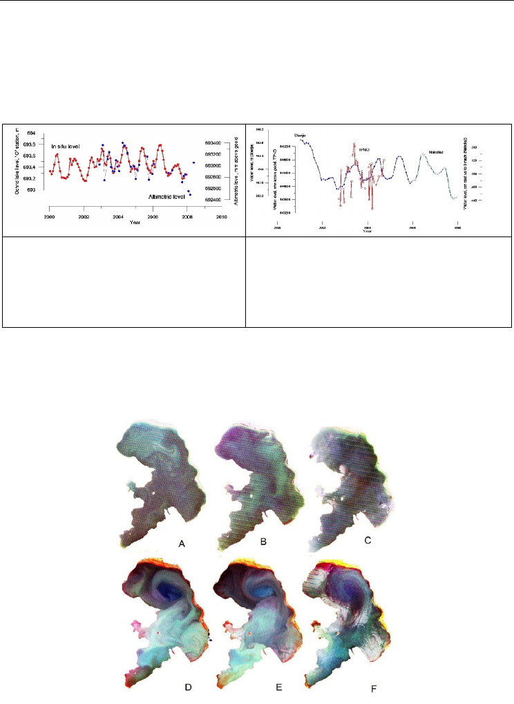
In the framework of the assessment of remote sensing techniques a small scale experiment
has been carried out using radar altimetry techniques by Alexei Kouraev (Stefouli et al
2008). Results show that there are annual variations of Ohrid lake water level and these
can be measured using radar altimetry. As Macro Prespa lake is hydraulically connected
to Ohrid lake and located in higher altitude these could explain its drop of the water level.
For some ENVISAT cycles estimates of water level have not been made due to quality
control. The difference between the two time series can be up to 15-20 cm, apparently due
Monitoring Lake Ecosystems Using Integrated Remote
Sensing / Gis Techniques: An Assessment in the Region of West Macedonia, Greece
195
to land influence in altimetric signal, but in general both in situ and altimetric observation
are in good agreement, Figure 11. Time series water level measurements can be obtained
through the process of radar altimetry and if it is combined with the estimated surface
areas, lake bathymetry can give an indication of the quantitative characteristics of the
lakes.
(A) In situ (red line and dots) and altimetric
(blue line and dots) water level time series of
Ohrid lake. Though absolute values differ for Y
axis, vertical scales are identical for both.
(B) In situ (blue line and small dots for Stenje station
and dark blue line and open circles for Nakolez
station) and altimetric TPNO (red line with open
circles) water level time series for Macro Prespa lake.
Though absolute values differ for Y axis, vertical
scales are identical.
Fig. 11. Results of applying test for estimating water level of lakes from radar altimetry
data.
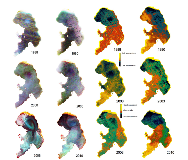
Fig. 12. Seasonal changes of Macro Prespa lake shown on the Landsat images of the year 2010:
A. 14 / November B. 4 / April C.7 / June & D./ E./F. 2 / 18 / 26 of August respectively.
Environmental Monitoring
196
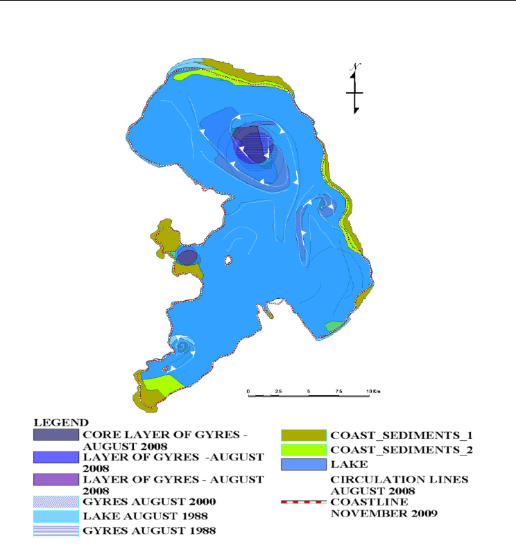
Fig. 13. Surface currents as mapped on using visible part of the spectrum (left image) and
the thermal bands (right image) of the summer Landsat images for the period 1988 – 2010.
The images have shown that wind-driven partial upwelling events occur at least throughout
the summer stratified period, transporting water from intermediate depths to the surface.
These are important events that contribute to the patchiness and heterogeneity that
characterize natural aquatic systems. The circulation in Lake Prespa is typically dominated
by the northern two-gyre pattern, especially in the summer. The north wind leads to a
cyclone (a counterclockwise rotation gyre) in the southwest and an anticyclone (a clockwise
rotation gyre) in the northeast.
Analysis shows that a well formed system of gyres is formed during summer D,E,F of the
year 2010 while this is not apparent in other seasons of the year i.e. winter / spring or
autumn. These results have also been confirmed from the lake surfaces extracted from the ~
30 years time span. Inter annual changes of the surface currents have been also evaluated.
Circular features have been mapped in summer season of every year while some results are
shown in Figure 13. These prominent features have been identified in most of the Landsat
images. Self organization techniques classification techniques of the visible part of the
spectrum proved to be quite effective in mapping lake circulation patterns. Multitemporal
data are stored in the GIS database, while synthetic maps can be produced, Figure 14.
Monitoring Lake Ecosystems Using Integrated Remote
Sensing / Gis Techniques: An Assessment in the Region of West Macedonia, Greece
197
Fig. 14. Synthetic map concerning coastal sediment concentrations surface currents in the
form of gyres.
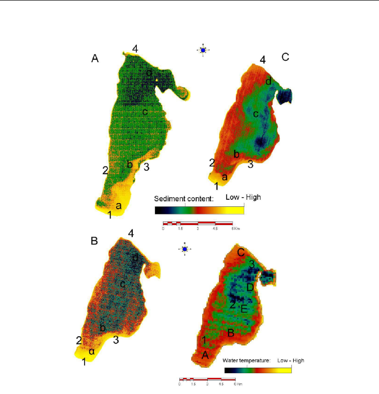
The Landsat and ASTER data have been analyzed for estimating differences of suspended
sediment content in Vegoritis lake. The data of band 2 of Landsat images (A, B in Figure 15)
and band 1 of the ASTER image (C in Figure 15) have been used in the analysis as they
correspond to the same spectral region of 0.52-0.60 μm. The same color palette has been
used for displaying the multi-temporal images. Blue-green colors show relatively low
sediment content while red - yellow colours high content. The Vegoritis lake thermal regime
is also displayed in Figure 15. Inflow patterns of sediments can be interpreted on the
satellite imagery in the different acquisition dates. Numbers 1 to 4 show the location of the
streams / canals that discharge into the lake.
Environmental Monitoring
198
Fig. 15. Circulation patterns of Vegoritis lake a to d: field sampling points.
The high-spatial-resolution TIR images provide a detailed view of fine-scale processes, such
as surface jets, that cannot be clearly resolved in moderate-resolution images, and they
enable the accurate measurement of surface transport and circulation patterns.
The high spatial resolution of ASTER and ETM+ images allow the surface currents and
general circulation in lakes and coastal environments to be accurately delineated. The vector
field delineates three gyres as shown in Figure 14, Convergence and divergence zones and
inflows can also be clearly resolved in the thermal patterns of the high-resolution TIR
satellite images. The analysis enabled the characterization of wind-driven upwelling and the
measurement of surface currents and circulation at lakes of West Macedonia. Trends during
the last ~25 years of lake hydraulics, concerning surface currents, turbulence charactiristics
and transport phenomena are identified.

Monitoring Lake Ecosystems Using Integrated Remote
Sensing / Gis Techniques: An Assessment in the Region of West Macedonia, Greece
199
Dates
(a)
Depth
0,5m
(b)
Depth
0,5m
(b)
Depth
5m
(c )
Depth
0,5m
(c)
Depth
5m
(d)
Depth
0,5m
(d)
Depth
5m
Mean
value
21-03-2000 1,0 2,1 2,6 2,6 2,1
4-04.2000 2,20 2,80 2,60 2,5
16-04-2000 2,40 2,60 2,60 2,5
7-05-2000 0,50 1,00 2,20 2,40 1,5
22-05 2000 0,7 1,60 1,70 1,50 1,4
5-06-2000 0,5 1,80 2,80 2,40 1,9
21-06-2000 0,8 2,20 2,60 2,40 2,0
10-07-2000 0,5 2,10 2,30 2,20 1,8
16-07-2000 0,6 1,6 1,8 2 1,5
Table 1. Sechi measurements in locations a,b,c,d of Figure 15 with variable depth and in
various dates of the year 2000
5.1.3 Suspended sediments – chlorophyll
Optical remote sensing of inland waters has become a task of increasing importance, since the
availability of clean fresh water is one of the great environmental challenges. In particular
natural lakes and artificial reservoirs have to be monitored on a regular basis to ensure the
quality of the water. With its 300 m spatial resolution and 15 spectral bands the imaging
spectrometer MERIS on ENVISAT can be used for monitoring of at least larger inland waters.
However, the standard algorithms as used for open ocean or even coastal waters are not
appropriate because different water constituents occur in particular different phytoplankton
blooms with partly extreme high concentrations. To this end the CASE 2 REGIONAL (C2R)
processor of the BEAM 4.9 (Envisat/Brockman Consult) has been developed.
A time series of MERIS full-resolution (300 m spatial resolution at nadir) imagery was obtained
from ESA's rolling archive at ESRIN https://oa-es.eo.esa.int/ra/mer_frs_l1/index.php and
processed using BEAM 4.9. Images were subset to a geographic region bounded by the lat/lon
limits of the study area. The BEAM 4.9 C2R processor was applied to data to extract
atmospherically corrected radiance and the algal product C2R Chl_conc, according to the
methods of Doerffer and Schiller (Doerffer and Schiller, 2008a, b). Default settings were
accepted for all processing parameters. The algorithm used for the retrieval of water
constituents is based on the Case-2-Water Bio-Optical Model. The input to the algorithm are the
water leaving radiance reflectances (i.e. the output of the atmospheric correction ) of 8 MERIS
bands. The algorithm derives data of the inherent optical properties total scattering of particles
(total suspended matter, tsm) b_tsm, the absorption coefficient of phytoplangton pigments
a_pig and the absorption of dissolved organic matter a_gelb (gelbbstof) all at 443nm (MERIS
band 2). Hence the concentrations of phytoplankton chlorophyll and of total suspended dry
weight are determined. The algorithm is based on a neural network which relates the
bidirectional water leaving radiance reflectances with these concentration variables. We
estimated the concentrations of two parameters: chlorophyll and total suspended matter.
As was already pointed the test area is a cross border area between 3 different countries so it
is not easy to establish a classification scheme and find the suitable variables and
classification limits for a common water quality classification system. However, a relative
classification scheme can be created using MERIS images. According to results shown in
Environmental Monitoring
200
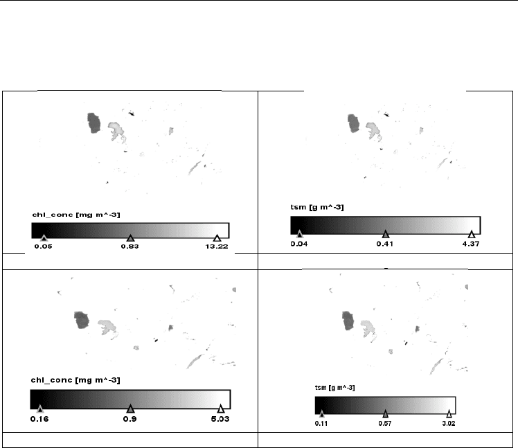
Fig. 16, the quality of water in the lake Ohrid is the highest among all lakes. Then follows
Macro Prespa, Micro Prespa and Vegoritis while Petron shows the worst water quality. This
MERIS based relative classification of lakes coincides with the classification based on the
available in situ data observations.
CHL Concentration Au
g
ust 2007 TSM Au
g
ust 2007
CHL concentration Au
g
ust 2009 TSM Au
g
ust 2009
Fig. 16. Chl concentration and tsm
5.2 Catchment areas of lakes
Water authorities need tools to monitor and assess the status and the changes of basins so as
to optimize and regulate their usage and to avoid depletion of the water resources. Up to
date information about land cover, land use, vegetation status and their changes over time
(e.g. seasonally) is important for the understanding and modelling of hydrological processes
such as infiltration, runoff rates, evapotranspiration and water needs. Additional EO-
derived information such as land cover, DEMs (digital elevation models) or surface water
variations can be used to infer properties of surface waters and aquifers, or used in water
cycle models (e.g. to calculate evapotranspiration). In order to interpret these discrepancies
the water basin status and the changes that are taking place need to be analyzed.
The collected information is reviewed and analyzed and the result of the compilation is
shown in the form of various maps. Multi-temporal analysis of Landsat- 5 / 7, Enhanced
Thematic Mapper Plus (ETM+) scenes, Envisat MERIS and one ASTER scene have been
used in the analysis of the catchment areas. Special emphasis is given on the catchment
delineation using DEMs available for the lake basins. The analysis included various types of
DEMs like the SRTM (100 m resolution) and ASTER (30 m resolution) DEMs. Catchments of
river networks are fundamental to the automation of flow-routing management in