Ekundayo E.O. Environmental monitoring
Подождите немного. Документ загружается.

Landscape Environmental Monitoring:
Sample Based Versus Complete Mapping Approaches in Aerial Photographs
211
within landscape. Both
ˆ
i
j
E
and
ˆ
t
E
can unbiasedly be estimated by Eq. 6. In contrast to Eq. 7,
a value of 1 from Eq. 8 indicates a fragmented landscape with many small patches.
2.2.4 Monte-Carlo sampling simulation
In this study, Monte-Carlo sampling simulation was used to assess statistical performance
(bias and RMSE) of estimators of the selected metric. Bias (or systematic error) is the
difference between the expected value of the estimator and the true value. RMSE is the
square root of the expected squared deviation between the estimator and the true value.
In point sampling, simulation was conducted for four sample sizes (49, 100, 225, and 400) for
both Shannon’s diversity and total edge length and five buffer widths (5, 10, 20, 40, and
80 m) for total edge length. In line intersect sampling, simulation was conducted for four
sample sizes (16, 25, 49, and 100), three line transect length (37.5, 75, and 150 m), and five
transect configurations (Straight line, L, Y, Triangle, and Square shapes). In point pairs
sampling (i.e., using Eq.7) simulation was conducted for nine point distances (2, 5, 10, 20, 30,
60, 100, 150, and 250 m) and five sample sizes (25, 49, 100, 225, and 400). Systematic and
simple random sampling designs were employed for all cases above.
3. Results
In this study, the statistical properties (RMSE and bias) of the estimators of the selected
metrics were investigated for different sampling combinations. But some major results are
presented here. In general, a systematic sampling design resulted in smaller RMSE and bias
compared to simple random design, for all combinations.
3.1 Shannon’s diversity index
In point sampling, both RMSE and bias of Shannon’s diversity estimator tended to decrease
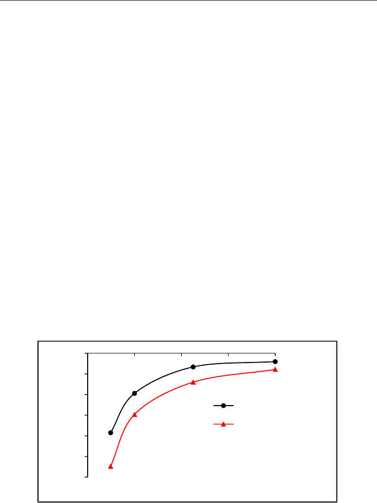
with increasing sample size in both sampling designs. In Fig. 4 is shown the relationship
between bias and sample size of Shannon’s diversity estimator in systematic and random
sampling designs.
Fig. 4. The relationship between bias and sample size of Shannon’s diversity estimator using
point sampling method in systematic and random sampling designs (from Ramezani et al.,
2010).
-6
-5
-4
-3
-2
-1
0
0 100 200 300 400
Bias (%)
Sample size
Systematic design
Random design
Environmental Monitoring
212
In line intersect sampling, similar to point sampling, both RMSE and bias of Shannon’s
estimator tended to decrease with increasing sample size and line length. The longer line
transect (here 150 m) resulted in lower RMSE and bias than shorter one (here 37.5 m), for a
given sample size. We found a small and negative bias for the estimator in both point and
the LIS methods. The magnitude of bias tended to decrease both with increasing sample size
and line transects length. Straight line configuration resulted in lower RMSE and bias than
other configurations.
3.2 Total edge length
In point sampling, the magnitude of RMSE of estimator is highly related to buffer width, for
a given sample size and a wide buffer resulted in lower RMSE than narrow one. The edge
length estimator had bias since parts of buffer close to the map border were outside the
map. Bias of estimator tended to increase with increasing buffer width whereas it was
independent on sample size. To eliminate or reduce the bias of estimator three corrected
methods were suggested which have been discussed in detilas in Ramezani et al. (2010).
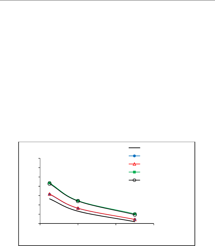
In LIS, the magnitude of RMSE of estimator is dependent on the length of the line transect,
for a given sample size and the longer transect resulted in lower RMSE than short one.
Furthermore, straight line configuration resulted in lower RMSE compared to other
configurations (e.g., L and square shape). In Fig. 5 is shown the relationship between
relative RMSE and sampling line lengths of total edge length estimator.
Fig. 5. Relative RMSE of total edge length estimator for different sampling line lengths and
configurations of line intersect sampling, for a given sample size (from Ramezani and Holm,
2011c).
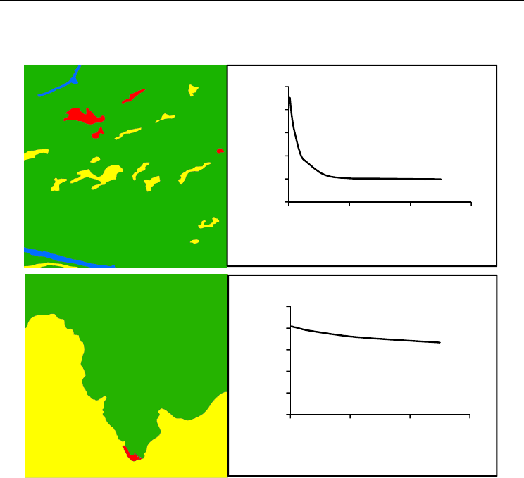
3.3 Contagion
Point based contagion (i.e., Eq. 7) is a distance–dependent function that delivers a contagion
value that decreased with increasing point distance. The rate of decrease of the contagion
value was faster in a fragmented landscape compared to a more homogenous landscape.
Examples of such landscapes are shown in Fig. 6. The contagion estimator was biased even
20
30
40
50
60
70
80
90
25 75 125 175
RMSE (%)
Sampling line length per configuration (m)
straight line
L - shape
Y - shape
Triangle shape
Square shape
Landscape Environmental Monitoring:
Sample Based Versus Complete Mapping Approaches in Aerial Photographs
213
if its component (i.e., ( )
ij
p
d ) was estimated without bias. The sources of bias discussed in
details in Ramezani and Holm (2011b).
Fig. 6. Example of two landscapes with different degree of fragmentation and their
corresponding contagion function (Eq. 7). Top: a high fragmented landscape (four land
cover class and nineteen patches) with large rate of decrease of the contagion function.
Bottom: a homogenous landscape (three land cover class and three patches) with a small
rate of decrease in the contagion function.
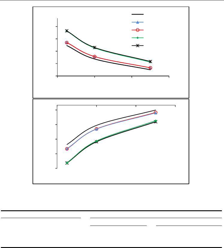
In line intersect sampling, both RMSE and bias of the contagion estimator (Eq.8) tended to
decrease with increasing sample size and line transects length. Straight line configuration
resulted in lower RMSE and bias than other configurations. We found a small and negative
bias for the contagion estimator despite its components (i.e.,
ˆ
i
j
E
and
ˆ
t
E
) can be estimated
without bias. The relative RMSE and bias of the contagion estimator through line intersect
sampling (LIS) method (Eq.8) is shown in Fig. 7. Note that the two contagion estimators
differ as they are based on different equations (i.e., Eqs.7 and 8).
A comparison was also made for variability in terms of range and mean in sample based
estimates of Shannon’s diversity, edge length and contagion metrics for sample sizes 16 and
100. In Table 1 is provided an example for line intersects sampling method, systematic
sampling design, straight line configuration and line length 37.5 m.
0.8
0.8
0.9
0.9
0.9
0.9
0 100 200 300
Contagion
Point distance (m)
0
0.2
0.4
0.6
0.8
1
0 100 200 300
Contagion
Point distance (m)
Environmental Monitoring
214
Fig. 7. Relative RMSE (top) and bias (bottom) of contagion estimator (Eq. 8) for different
sampling line lengths and configurations, a sample 49 and systematic sampling design
Landsca
p
e metrics
Sam
p
le size
16
100
Shannon’ diversit
y
0.398
(
0.019-0.747
)
0.423
(
0.026-0.784
)
Conta
g
ion
a
0.188
(
0.006-0.478
)
0.407
(
0.226-0.758
)
Total ed
g
e len
g
th
(
m ha
-1
)
92.2
(
12.2-197.6
)
92.1
(
10.5-194.6
)
a
according to Eq.8
Table 1. Variability (mean) in sample based estimates of Shannon’s diversity, edge length and
contagion in fifty random landscapes (NILS plots) in Sweden for sample sizes 16 and 100. Data
collected using line intersects sampling method, systematic sampling design, straight line
configuration and 37.5 m length of sampling lines. Ranges are given in parentheses.
3.4 Time study (cost needed for data collection)
A time study was conducted on non-delineated aerial photos from NILS employing an
experienced photo interpreter. The results of the time study for Shannon’s diversity and
total edge length are summarized in Tables 2 and 3.
15
30
45
60
75
25 75 125 175
RMSE (%)
Sampling line length per configuration (m)
Straight line
L shape
Y shape
Triangle shape
square shape
-80
-65
-50
-35
-20
25 75 125 175
Bias (%)
Sampling line length per configuration (m)
45
35
25
15
5
Square shape
0
-10
-20
-30
-40

Landscape Environmental Monitoring:
Sample Based Versus Complete Mapping Approaches in Aerial Photographs
215
Method Time needed (h)
Complete mapping 3.5
Point sampling (number of points)
9 0.4
100 0.8
225 1.9
400 3.3
Table 2. Average time consumption of data collection on five NILS plots for point sampling
and complete mapping for deriving the Shannon’s index (from Ramezani et al. (2010))
Sampling method Time needed (min)
Edge length estimator Shannon’ s diversity estimator
Point sampling 25
a
28.3
LIS 18.3
b
60
b
a
(buffer 40 (m))
b
(line 150 (m))
Table 3. Average time needed for point and line intersect sampling (LIS) methods for
deriving Shannon’s diversity and total edge length. For sample size 100 (number of point
and lines)
The time needed to collect data was highly related to landscape complexity and the
classification system applied. We also found that in a coarse classification system the time
needed was less than in a more detailed system. This issue becomes more serious in
complete mapping approaches where all potential polygons should be delineated.
Furthermore, time was also dependent on sampling method the chosen. With a point
sampling method less time was needed for estimating Shannon’s diversity compared with
other metrics. With line intersect sampling; it was more time efficient to use edge-related
metrics. For a given sample size, the time depended on the length of line transect (in LIS)
and the buffer width (in point sampling). With the former method it is indicated that the
time is independent on line configuration in the aerial photo.
4. Discussion
This study addresses the potential of sampling data for estimating some landscape metrics
in remote sensing data (aerial photo). Sample based approach appears to be a very
promising alternative to complete mapping approach both in terms of time needed (cost)
and data quality (Kleinn and Traub, 2003; Corona et al., 2004; Esseen et al., 2006). However,
some metrics may not be estimated from sample data regardless of chosen sampling method
since currently used landscape metrics are defined based on mapped data. To describe
landscape patterns accurately, a set of landscape metrics is needed since all aspect of
landscape composition and configuration cannot be captured through a single metric. On
the other hand, all metrics cannot be extracted using a single sampling method. Thus, in a
sample based approach a combination of different sampling methods is needed, for
instance, a combination of point and line intersect sampling. In such combined design, the

Environmental Monitoring
216
start, mid and end points of line transects can be treated as grid of points which is preferred
for estimating area proportions of different land cover classes within a landscape and thus
Shannon’s diversity. It would also be effective in terms of cost if several metrics could
simultaneously be derived from a single sampling method.
From a statistical point of view unbiasedness is a desirable property of an estimator. In
sample based assessment of landscape metrics, attributes (metrics components) such as
the number, size, and edge length of patches must unbiasedly be estimated (Traub and
Kleinn, 1999) if an unbiased estimate is needed. However, this is a necessary but not
sufficient conditions (Ramezani, 2010). For instance, in the case of Shannon’ diversity,
there is still bias despite its component i.e., area proportions of land cover classes can be
estimated without bias through both point and line intersect sampling methods
(Ramezani et al., 2010; Ramezani and Holm, 2011c). The bias is due to non–linear
transformation, which also generally is the case for other metrics with non–linear
expression such as contagion. Bias of selected metric estimators is very small if the sample
size is large and the magnitude of bias depends jointly on type of selected metric, the
sampling method, and the complexity of the landscape structure. To achieve an acceptable
precision in a complex landscape there is a need for a larger sample size compared to the
homogenous landscape.
The landscape metrics used in this study are based on a patch-mosaic model where sharp
borders are assumed between patches. In such procedure, as noted by Gustafson (1998) the
patch definition is subjective and depends on criterion such as the smallest unit that will be
mapped (minimum mapping units, MMU). This becomes more challenging in a highly
fragmented landscape where smaller patches than predefined MMU are neglected. Even
though these patches constitute a small proportion (area) of the landscape, they contribute
significantly to the overall diversity of that landscape; including biodiversity where other
type organisms may occupy these patches habitats. However, in sample based approach
which can be conducted in non–delineated aerial photos, there is no need to predefine
minimum patch size and even very small patches can be included in the monitoring system.
Furthermore, point sampling appears to be in consistent with gradient based model of
landscape (McGarigal and Cushman, 2005) where landscape properties change gradually
and continuously in space and where no subjective sharp border need to be assumed
between patches.
Polygon delineation errors are common in manual mapping process. It can be assumed that
this error can be eliminated when sampling methods are used for estimating some
landscape metrics. As a result, obtained information and subsequent analysis is more
reliable than for traditional manual polygon delineation. As an example, for estimating the
metrics Shannon’s diversity and contagion using point sampling, no mapped data are
needed and assessment is only concentrated on sampling locations. This is also true for the
LIS, for instance, the total length estimation of linear features within a landscape is to be
based on simply counting the interactions between lines transect and a potential patch
border. Consequently, assessment is conducted along line transect which, thus, considerable
reduce the polygon delineation error.
It is clear, however, that a sample based approach cannot compete with a complete mapping
approach, in particular when high quality mapped data is available. With the mapping
approach a suite of metrics can be calculated for patch, class, and landscape levels whereas
in sample based approach a limited number of metrics on landscape level can often be
estimated.

Landscape Environmental Monitoring:
Sample Based Versus Complete Mapping Approaches in Aerial Photographs
217
5. Conclusion
A sample based approach can be used complementary to complete mapping approach, and
adds a number of advantages, including 1) the possibility to extract metrics at low cost 2)
applicable in case of lacking categorical map of entire landscape 3) the possibility in some
case to obtain more reliable information and 4) the possibility of estimating some metrics
from ongoing field-based inventory such as national forest inventories (NFI). In some cases,
there is a need to slightly redefine currently used landscape metrics or develop new metrics
to meet sample data. There is obviously plenty of room for further studies into this topic
since sample based assessment of landscape metrics is a new approach in landscape
ecological surveys.
6. References
Blaschke, T., (2004). Object-based contextual image classification built on image
segmentation: IEEE Transactions on Geoscience and Remote Sensing, p. 113-119.
Bunce, R.G.H., Metzger, M.J., Jongman, R.H.G., Brandt, J., de Blust, G., and Elena-Rossello,
R., et al., (2008). A standardized procedure for surveillance and monitoring
European habitats and provision of spatial data: landscape Ecology, v. 23, p. 11-25.
Cochran, G., (1977). Sampling techniques: New York, Wiley, xvi, 428 p.
Corona, P., Chirici, G., and Travaglini, D., (2004). Forest ecotone survey by line intersect
sampling: Canadian Journal of Forest Research-Revue Canadienne De Recherche
Forestiere, v. 34, p. 1776-1783.
Esseen, P.A., Jansson, K.U., and Nilsson, M., (2006). Forest edge quantification by line
intersect sampling in aerial photographs: Forest Ecology and Management, v. 230,
p. 32-42.
Fischer, J., and Lindenmayer, D.B., (2007). Landscape modification and habitat
fragmentation: a synthesis: Global Ecology and Biogeography, v. 16, p. 265-280.
Gregoire, T.G., and Valentine, H.T., (2008). Sampling Strategies for Natural Resources and the
Environment Boca Raton, Fla. London, Chapman & Hall/CRC.
Gustafson, J.E., (1998). Quantifying landscape spatial pattern: What is the state of the art?:
Ecosystems, v. 1, p. 143-156.
Hanski, I., (2005). Landscape fragmentation, biodiversity loss and the societal response - The
longterm consequences of our use of natural resources may be surprising and
unpleasant: Embo Reports, v. 6, p. 388-392.
Jansson, K.U., Nilsson, M., and Esseen, P.-A., (2011). Length and classification of natural and
created forest edges in boreal landscapes throughout northern Sweden: Forest
Ecology and Management.v.262,P.461-469
Kleinn, C., and Traub, B., (2003). Describing landscape pattern by sampling methods, in
Corona, P., Köhl, M., and Marchetti, M., eds., Advances in forest inventory for
sustainable forest management and biodiversity monitoring., Volume 76, p. 175-189.
Li, H., and Reynolds, J., (1993). A new contagion index to quantify spatial patterns of
landscapes: Landscape Ecology, v. 8, p. 155-162.
Matérn, B., (1964). A method of estimating the total length of roads by means of line survey:
Studia forestalia Suecica, v. 18, p. 68-70.
McGarigal, K., and Cushman, S.A., (2005). The gradient concept of landscape structure, in
Wiens, J., and Moss, M., eds., Issues and perspectives in landscape ecology: Cambrideg,
Cambrideg University press.

Environmental Monitoring
218
McGarigal, K., and Marks, E.J., (1995). FRAGSTATS: Spatial pattern analysis program for
quantifying landscape pattern. General Technical Report 351. U.S. Department of
Agriculture, Forest Service, Pacific Northwest Research Station.
Morgan, J., Gergel, S., and Coops, N., (2010). Aerial Photography: A Rapidly Evolving Tool
for Ecological Management: BioScience, v. 60, p. 47-59.
NIJOS, (2001). Norwegian 3Q Monitoring Program: Norwegian institute of land inventory.
O’Neill, R.V., Krumme, J.R., Gardner, H.R., Sugihara, G., Jackson, B., DeAngelist, D.L.,
Milne, B.T., Turner, M., Zygmunt, B., Christensen, S.W., Dale, V.H., and Graham,
L.R., (1988). Indices of landscape pattern: Landscape Ecology v. 1, p. 153-162.
Raj, D., (1968). Sampling theory: New York, McGraw-Hill, 302pp. p.
Ramezani, H., (2010). Deriving landscape metrics from sample data (PhD thesis): Umeå,
Swedish University of Agricultural Sciences (SLU).
Ramezani, H., and Holm, S., (2011a). A distance dependent contagion functions for vector-
based data: Environmental and Ecological Statistics (accepted).
—, (2011b). Estimating a distance dependent contagion function using point sample data (in
review).
—, (2011c). Sample based estimation of landscape metrics: accuracy of line intersect
sampling for estimating edge density and Shannon’s diversity . Environmental and
Ecological Statistics, v. 18, p. 109-130.
Ramezani, H., Holm, S., Allard, A., and Ståhl, G., (2010). Monitoring landscape metrics by
point sampling: accuracy in estimating Shannon’s diversity and edge density:
Environmental Monitoring and Assessment v. 164, p. 403-421.
Ries, L., Fletcher, R.J., Battin, J., and Sisk, T.D., (2004). Ecological responses to habitat edges:
Mechanisms, models, and variability explained: Annual Review of Ecology
Evolution and Systematics, v. 35, p. 491-522.
Riitters, K.H., O'Neill, R.V., Hunsaker, C.T., Wickham, J.D., Yankee, D.H., Timmins, S.P.,
Jones, K.B., and Jackson, B.L., (1995). A factor-analysis of landscape pattern and
structure metrics: Landscape Ecology, v. 10, p. 23-39.
Saura, S., and Martinez-Millan, J., (2001). Sensitivity of landscape pattern metrics to map
spatial extent: Photogrammetric Engineering and Remote Sensing, v. 67, p. 1027-
1036.
Ståhl, G., Allard, A., Esseen, P.-A., Glimskär, A., Ringvall, A., Svensson, J., Sture Sundquist,
S., Christensen, P., Gallegos Torell , Å., Högström, M., Lagerqvist, K., Marklund, L.,
Nilsson, B., and Inghe, O., (2011). National Inventory of Landscapes in Sweden
(NILS) - Scope, design, and experiences from establishing a multi-scale biodiversity
monitoring system: Environmental Monitoring and Assessment v. 173, p. 579-595.
Takács, G., and Molnár, Z., (2009) National biodiversity monitoring system XI. Habitat
mapping (2nd modified ed., p. 54). Ministry of Environment and Water, Budapest.
Traub, B., and Kleinn, C., (1999). Measuring fragmentation and structural diversity:
Forstwissenschaftliches Centralblatt, v. 118, p. 39-50.
Wickham, J.D., Riitters, K.H., ONeill, R.V., Jones, K.B., and Wade, T.G., (1996). Landscape
'contagion' in raster and vector environments: International Journal of
Geographical Information Systems, v. 10, p. 891-899.
Wulder, M.A., White, J.C., Hay, G.J., and Castilla, G., (2008). Towards automated
segmentation of forest inventory polygons on high spatial resolution satellite
imagery: Forestry Chronicle, v. 84, p. 221-230.
14
Real-Time Monitoring of Volatile
Organic Compounds in Hazardous Sites
Gianfranco Manes
1
, Giovanni Collodi
1
, Rosanna Fusco
2
,
Leonardo Gelpi
2
, Antonio Manes
3
and Davide Di Palma
3
1
Centre for Technology for Environment Quality & Safety, University of Florence,
2
eni SpA,
3
Netsens Srl,
Italy
1. Introduction
Volatile Organic Compounds (VOCs) are largely used in many industries as solvents or
chemical intermediates. Unfortunately, they include some components, present in the
atmosphere, that can represent a risk factor for human health. They are also present as a
contaminant or a by-product in many processes, i.e. in combustion gas stacks and
groundwater clean-up systems.
Benzene, in particular, shows a high toxicity resulting in a Time-Weighted Average
(TWA) limit of 0.5 ppm, as compared, for instance, with TWA for gasoline, in the range of
300 ppm.
Detection of VOCs at sub-ppm levels is, thus, of paramount importance for human safety
and industrial hygiene in hazardous environments.
The commonly used field-portable instruments for VOC detection are the hand-held
Photo-Ionisation Detectors (PIDs), sometime using pre-filter tubes for specific gas detection.
PIDs are accurate to sub-ppm, measurements are fast, in the range of one or two minutes
and, thus, compatible with on-field operation. However, they require skilled personnel and
cannot provide continuous monitoring.
Wireless connected hand-held PID Detectors start being available on the market, thus
overcoming some of the previously described limitations, but suffering for the limited
battery life and relatively high cost.
The paper describes the implementation and on-field results of an end-to-end distributed
monitoring system integrating VOC detectors, capable of performing real-time analysis of
gas concentration in hazardous sites at unprecedented time/space scale.
The system consists of a Wireless Sensor Network (WSN) infrastructure, whose nodes are
equipped with distributed meteo-climatic sensors and gas detectors, of TCP/IP over GPRS
Gateways forwarding data via Internet to a remote server and of a user interface which
provides data rendering in various formats and access to data.
The paper provides a survey of the VOC detector technologies of interest, of the state-of-the-
art of the fixed and area wireless technologies available for Gas detection in hazardous areas
and a detailed description of the WSN based monitoring system.

Environmental Monitoring
220
2. Regulatory requirements for oil&gas industry
The oil&gas sector is characterised by a high complexity in terms of processes, materials and
final products. Consequently, activities related to the oil&gas industry need to be effectively
controlled to minimize their impact on the environmental matrices (air, water and soil) and
to avoid any potential risks for human health.
Environmental issues related to the oil&gas sector are also strictly dependent on the specific
activities performed. In particular, petrochemical and refining sectors are involved in the
production of waste materials, such as water and toxic sludge, and atmospheric pollutant
emissions, including many VOCs potentially harmful both to the environment and to
human health. All these environmental issues are considered areas of high human and
environmental risk and therefore subject to stringent international and local environmental
regulations.
During the last decade the EU has fixed several Thematic Strategies to improve the
management and control on Air Pollution, Soil Protection, Prevention and Recycling of
Waste as a follow-up to the Sixth Community Environment Action Programme (Council of
22
nd
July 2002). In particular, the EU set objectives and regulations on the industrial sector to
protect human health and the environment, objectives can be met only with further
reductions in emissions arising from industrial activities. The final act of this process was
the publication, on 24
th
November 2010, of the new Directive 75/2010 (IED) on industrial
emissions (integrated pollution prevention and control) which recasts together six directives
on industrial emissions (IPPC, LCP, VOC, TiOxide).
Based on the principle of the polluter pays and also on the pollution prevention one, industrial
owners should manage their activities in order to protect the environment as a whole, in
compliance to the IPPC integrated approach. Furthermore, in accordance with the Århus
Convention on access to information and public participation, operators should both
improve and promote tools and procedures, such as adopting environmental management
system (ISO 14001), increasing the accountability and transparency of the monitoring and
reporting data process and contributing to public awareness of environmental issues, and
support for the decisions taken.
In order to ensure the prevention and control of pollution, each installation should operate
only if it holds a permit, which should include all the measures necessary to achieve a high
level of protection of the environment as a whole, and to ensure that the installation is
operated in accordance with the general principles governing the basic obligations of the
operator. The permit should also include emission limit values for polluting substances or
technical measures and monitoring requirements; all conditions should be set on the basis of
Best Available Techniques (BAT)
1
applied on each specific installation.
On the other hand, the European Union has issued, in 2008, Directive No 2008/50/EC
concerning ambient air quality and cleaner air for Europe.
In order to protect human health and mostly urban environment, the directive addresses the
following key points:
1
In the IPPC Directive, BAT are defined as “the most effective technologies available for achieving a
high level of environmental protection concerned in an economically feasible and technical view of the
costs and benefits”. Currently BAT is identified on the basis of an exchange of information organized by
the European Commission that occurs between the Member States, industry and non-governmental
organisations