Ekundayo E.O. Environmental monitoring
Подождите немного. Документ загружается.

Monitoring Lake Ecosystems Using Integrated Remote
Sensing / Gis Techniques: An Assessment in the Region of West Macedonia, Greece
201
distributed hydrologic models and for the morphometric evaluation of river network
structure. The analysis of the DEM resulted to the delineation of the hydrographic network
of the area of the transnational Prespa basin. The ASTER DEM has been used to delineate
the changes of the relief of the Vegoritis lake basin.
Geology plays a role in the region as it allows the interconnections of adjacent river basins,
which is the case of Prespa and Ohrid lakes. Ground waters cannot be observed directly by
existing EO satellites, however, location, orientation and length of lineaments can be derived
from EO and can be used as input for studies of fractured aquifers (e.g. location of sites for
water harvesting). Available geologic maps have been scanned, geo referenced, digitized for
the whole region within the context of the GIS system, Figure 3. The original maps have
been of different scales and information content. A great variety of rocks with varying age
and lithology constitute the catchment areas. Available information on location of springs
has been also integrated in the GIS database.
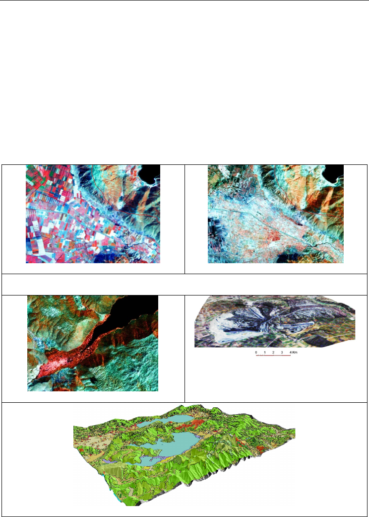
Α1. 1988
Α2. 2000
A1 & A2. Impact of the implementation of Government policies after the 1990’s as it shown
on the multi tem
p
oral ima
g
es of 1988 to 2000.
B. Emergent vegetation due to siltation
C. Mining activites. 3D representation of
relief changes due to surface mining as it is
mapped by the ASTER DEM & Landsat
ima
g
e of 2011.
D. Red areas show burned b
y
forest fires of 2007 overla
y
ed on the Corine land cover ma
p
.
Fig. 17. Impact of anthropogenic factors to the lakes of the study area.

Environmental Monitoring
202
Natural and anthropogenic processes take place in the basins of Prespa and Vegoritis lakes
and these have an impact on the water resources of the basins. The catchments of the three
lakes have been described by the GIS based analysis of “Corine Land Cover Classification”
Figure 17-D. MERIS data has been used for Corine land cover map updating because of their
improved temporal resolution. Burnt areas due to the 2007 forest fires are detected and
mapped on the MERIS data.
Surface mining takes place in Vegoritis lake basin with negative impacts of mining on the
water resources, both surface and groundwater, which occur at various stages of the life cycle
of the mines and even after their closure: 1.From the mining process itself, 2. From dewatering
activities which are undertaken to make mining possible. 3. During the flooding of workings
after extraction has ceased 4. By discharge of untreated waters after flooding is complete.
Anthropogenic factors seem to play a key role on the deterioration of the water resources of
the region. Integrated Earth Observation / GIS techniques help to monitor changes in lake
basins and can cover specific water management requirements, Table 2, Figure 17.
Anthropogenic Impact Comments
Transnational
treaties
First aggrement 1959- 2nd 2000 Prespa
Park 2/2/2010, Petersberg Process (1998),
Athens Declaration Process Water
Convention 1992, Karipsiadis2008
Implementation is suffering from
problems like lack of information,
insufficient data.
Infra-
structures
Diverson of Aghios Germanos (1936)
Diversion of Devolli river (mid-70's) It has
deposited about 1.2 million m3 of alluvium
in the shores of Micro Prespa Lake. Sluice
gates controlling flow of waters from
Micro to Macro Prespa lake (2004).
Figure 17_B shows the effect of Devolli
river diversion to Micro Prespa lake.
Mining
The environmental effects of the extraction
stage: Surface disturbance, and the
increased amount of sediments
transported to the lake.
Figure 17 C shows the effect of surface
mining in the Vegoritis lake basin.
Land cover
changes
Multitemporal changes of the surface of
lakes 1972-2009 period.
Land cover changes due to forest fires,
Figure 17 D
Social changes
After the fall of the Eastern Block regimes
the land was redistributed in Albania.
The total 550 agricultural cooperatives were
converted to 467,000 small holder farms.
These land management practices could
have driven or intensified different water
usage across Albania that would have
influenced hydrologic lake water
balances..Figure 17, A1 & A2
Agriculture
Irrigation schemes / pumping stations
were created during the period 1950-1980,
and occur on mainly flat, or gently sloping
and river terrace
Agriculture influence both the quantitative
/ qualitative characteristics of the lakes
Table 2. Selected natural / anthropogenic impacts on the water resources of lakes

Monitoring Lake Ecosystems Using Integrated Remote
Sensing / Gis Techniques: An Assessment in the Region of West Macedonia, Greece
203
An advantage of using remote sensing is that data for large areas within a single image can
be collected quickly and relatively inexpensively, while this can be repeated through
selected time intervals. It is clear that in order to make regional assessments, one must
develop a means to extrapolate from well-studied areas, as the site of our inter-comparison,
to other lakes. Since the strength of satellite imagery for lake monitoring is the regional scale
dimension, more than one location has to be taken for reference in order to learn how to
separate crucial environmental parameters from all kinds of important interfering
phenomena. Deterioration of water quantity and quality parameters is interpreted for Macro
Prespa & Vegoritis lakes, while Ohrid lake remains stable.
6. Discussion
Monitoring of the lake ecosystems is of paramount importance for the overall development
of a region. Remote sensing provides valuable information concerning different
hydrological parameters of interest to a lake assessment project. Monitoring is supported
due to the multi-temporal character of the data. Temporal changes for the last 30 years can
be analyzed with the use of satellite imagery. Processing techniques that have been applied
include integrated image processing / GIS vector data techniques. Satellite data generate
GIS database information required for hydrological studies and the application of models.
Neural network algorithms are quite effective for the satellite data classification. Generated
database can be used to assess changes that are taking place in the lakes and its surrounding
environment. The areal extent of the lakes has been mapped accurately in all cases. Using
the adopted methodology various parameters concerning the lakes and their basins can be
extracted related to the description of catchments, surface area, water-level, hydrogeology
and water quality characteristics of the lakes.
Water quality parameters of the lakes can be retrieved from remote sensing. Peristrophic
movements (gyres) can be clearly identified in the time series images, both in the optical and
thermal bands of the Landsat satellite system for the Macro Prespa lake. Understanding the
naturally occurring mixing processes in the lake aids in determining the ultimate fate of
pollutants, and supports the application of good management strategies and practice.
The high spatial resolution of the satellite images allow the surface currents and general
circulation in lakes to be accurately identified using the multi-temporal imagery. This
can assist in monitoring the clarity and general water quality of lakes. ENVISAT MERIS
satellite data have been used for the assessment of spatio-temporal variability of selected
water quality parameters like dispersion of suspended solids and chlorophyll concentration.
Deterioration of water quantity and quality parameters is interpreted for both Macro Prespa
and Vegoritis lakes. It is indicated that satellite monitoring is a viable alternative for spatio-
temporal monitoring purposes of lake ecosystems. However, technology alone is insufficient
to resolve conflicts among competing water uses. A more useful approach is to have specialists
to support decision makers by making available to them the use of data and techniques.
7. References
Bukata, R. P., Jerome J. H., & Burton J. E. (1988). Relationships among Secchi disk depth,
beam attenuation coefficient, and irradiance attenuation coefficient for Great Lakes
waters. Journal of Great Lakes Research, 14(3), 347-355.
Chacon-Torres, A., Ross, L., Beveridge, M. & Watson, A., 1992. The application of SPOT
multispectral imagery for the assessment of water quality in Lake Patzcuaro,
Mexico. International Journal of Remote Sensing, 13(4): 587-603.

Environmental Monitoring
204
Charou E., Katsimpra E., Stefouli M. & Chioni A., Monitoring lake hydraulics in West
Macedonia using remote sensing techniques and hydrodynamic simulation (2010)
Proceedings of the 6th International symposium on environmental Hydraulics, 22-
25 June 2010, pages 887-893.
Cox, R. M., Forsythe, R. D., Vaughan, G. E., & Olmsted, L. L. (1998). Assessing water quality
in the Catawba River reservoirs using Landsat Thematic Mapper satellite data.
Lake and Reservoir Management, 14, 405– 416.
Doerffer, R. & Schiller, H. (2008a). MERIS lake water algorithm for BEAM ATBD, GKSS
Research Center, Geesthacht, Germany. Version 1.0, 10 June 2008.
Doerffer, R. & Schiller, H. (2008b). MERIS regional, coastal and lake case 2 water project —
Atmospheric Correction ATBD. GKSS Research Center, Geesthacht, Germany.
Version 1.0, 18 May 2008.
Hartmann, H. C. (2005) Use of climate information in water resources management. In:
Encyclopedia of Hydrological Sciences, M.G. Anderson (Ed.), John Wiley and Sons
Ltd., West Sussex, UK, Chapter 202.
Liu, Y., Islam, M. and Gao, J., 2003. Quantification of shallow water quality parameters by
means of remote sensing. Progress in Physical Geography, 27(1): 24-43.
Nellis, M., Harrington, J. and Wu, J., 1998. Remote sensing of temporal and spatial variations
in pool size, suspended sediment, turbidity, and Secchi depth in Tuttle Creek
Reservoir, Kansas. Geomorphology, 21(3-4): 281-293.
Ritchie, J., Schiebe, F. and McHenry, J., 1976. Remote sensing of suspended sediment in
surface water. Photogrammetric Engineering and Remote Sensing, 42: 1539-1545.
Schiebe, F., Harrington, J. and Ritchie, J., 1992. Remote sensing of suspended sediments: the Lake
Chicot, Arkansas project. International Journal of Remote Sensing, 13(8): 1487 - 1509.
Schmugge, T., Kustas, W., Ritchie, J., Jackson, T. and Rango, A., 2002. Remote sensing in
hydrology. Advances in Water Resources, 25: 1367-1385.
Steissberg, T. E.; Hook, S. J.; Schladow, G. American Geophysical Union, Fall Meeting 2006,
abstract #H32D-01.
Stefouli M., Charou E., Kouraev A., Stamos A (2011) Integrated remote sensing and GIS
techniques for improving trans-boundary water management: The case of Prespa
region. In: Selection of papers from IV International Symposium on Transboundary
Waters Management, Thessaloniki, Greece, 15th – 18th October 2008 for
publication in Groundwater Series of UNESCO's Technical Documents , 174-179 pp.
Tyler, A., Svab, E., Preston, T., Présing, M. and Kovács, W., 2006. Remote sensing of the
water quality of shallow lakes: a mixture modelling approach to quantifying
phytoplankton in water characterized by high-suspended sediment. International
Journal of Remote Sensing, 27(8): 1521-1537.
Vrieling, A., 2006. Satellite remote sensing for water erosion assessment: a review. Catena, 65: 2-18.
Wallin, M. L., & Hakanson, L. (1992). Morphometry and sedimentation as regulating factors
for nutrient recycling and trophic level in coastal waters. Hydrobiologia, 235, 33-45.
Zhen-Gang Ji and Kang-Ren Jin 2006. Gyres and Seiches in a Large and Shallow Lake, in
(Volume 32, No. 4, pp. 764-775) of the Journal of Great Lakes Research, published
by the International Association for Great Lakes Research, 2006.
13
Landscape Environmental Monitoring:
Sample Based Versus Complete Mapping
Approaches in Aerial Photographs
Habib Ramezani
1
, Johan Svensson
1
and Per-Anders Esseen
2
1
Department of Forest Resource Management,
Swedish University of Agriculture Science, Umeå,
2
Department of Ecology and Environmental Science, Umeå University, Umeå,
Sweden
1. Introduction
Unknown land use premises are to be expected due to changing conditions, e.g. shifting
land use priorities, climate change, globalizing natural resource markets or new products in
the natural resource sector. As a result the need is obvious for accurate, relevant and
applicable landscape data to be used in cause–and–effect analysis concerning changes in
environmental conditions (Ståhl et al., 2011).
The current land use strongly influence landscape structure (composition and configuration)
and contribute to biodiversity loss (Hanski, 2005; Fischer and Lindenmayer, 2007). In order
to consider current status and also to monitor trends within a landscape there is a need for
reliable and continuous information as a basis for policy– and strategic – as well as
operational decision making (Bunce et al., 2008). For this purpose, many countries have now
established or are in the process of establishing monitoring programs that provide
information on large spatial scale (e.g., regional and national levels), for instance, the
National Inventory of Landscapes in Sweden (NILS) (Ståhl et al., 2011), the Norwegian 3Q
(NIJOS, 2001), and similar programs in other countries, e.g., in Hungary (Takács and
Molnár, 2009). A major concern in landscape monitoring at national scale is the large
complexity and amount of data, and the consequently the labor need in data acquisition,
database management as well as data analysis and interpretation.
Description and assessment of landscape conditions and changes require relevant, accurate
and applicable landscape metrics, which are defined based on measurable attributes of
landscape elements such as patches or boundaries. The suite of metrics must cover both the
composition and configuration of the landscape to have potential to detect changes within a
given landscape or when comparing different landscapes.
Calculation of landscape metrics is commonly conducted on completely mapped areas
based on remotely sensed data. FRAGSTATS (McGarigal and Marks, 1995) is a frequently
used software for this purpose. In mapping, homogenous areas are first delineated as
polygons. Aerial photo interpretation is usually performed using a manual approach while
some automated and computer–assisted approaches have recently become available (e.g.,
Blaschke, 2004). Important attributes in manual interpretation include tone, pattern, size and
Environmental Monitoring
206
shape (Morgan et al., 2010). The experience of the interpreters is critical and the results from
manual interpretation are thus often more accurate than those from automated approaches.
However, the manual approach may be time-consuming (Corona et al., 2004), subjective
(interpreter-dependent) and considerable variation may occur between photo interpreters.
The automated approach is sometimes unreliable, for instance, when land cover classes that
are similar in terms of spectral reflectance should be separated (Wulder et al., 2008). In
addition, overall time, including delineation and corrections may be large if an
inappropriate automated approach is chosen.
Sample based approach is an interesting alternative to extract landscape data compared to
complete mapping (Kleinn and Traub, 2003). The argument is that a sample survey takes
less time; that it is possible to achieve more accurate result in a well-designed and well-
executed sample survey; and that data can be acquired and analyzed more efficiently (Raj,
1968; Cochran, 1977). The efficiency and speed in delivering results is of particular interest
in landscape–scale monitoring programs where stakeholders commonly are closely involved
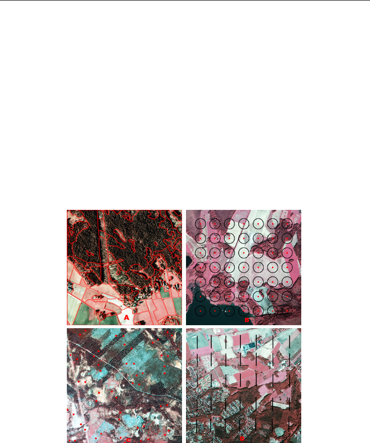
and expect outputs within reasonable time. Figure 1 shows examples of complete mapping
and sample based approaches (point and line intersect sampling methods) over 1 km × 1 km
aerial photo from NILS.
Fig. 1. Examples of complete mapping and sample based approaches to extract landscape
metrics in 1 km × 1 km aerial photo. A) Complete mapping, B) systematic point sampling
with fixed buffer (40 m), C) point pairs sampling, and D) systematic line intersect sampling.
Since aerial photos are important source of data for many ongoing environmental
monitoring programs such as NILS (Ståhl et al., 2011), there is an urgent need to investigate
the possibilities and limitations of both mapping and sample based approaches for
estimating landscape metrics. The overall objective of this chapter is to compare the
Landscape Environmental Monitoring:
Sample Based Versus Complete Mapping Approaches in Aerial Photographs
207
advantages and limitations of complete mapping versus sample based approaches for
estimating landscape metrics Shannon’s diversity, total edge length and contagion from
aerial photos. The specific objectives are: (1) to compare point and line intersect sampling for
selected metrics in terms of the level of detail and accuracy of data extracted, and the time
needed (cost) to extract the data, (2) to compare sample based and complete mapping
approaches in terms of time needed, and (3) to investigate statistical properties (bias and
RMSE) of estimators of selected metrics using Monte-Carlo sampling simulation.
2. Material and methods
2.1 Study area
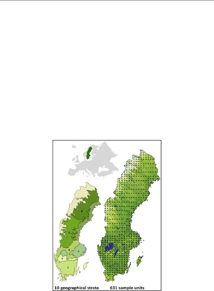
The data was collected from aerial photographs and land cover maps from the NILS
program (Ståhl et al., 2011), which covers the whole of Sweden. NILS was developed to
monitor conditions and trends in land cover classes, land use and biodiversity at multiple
spatial scales (point, patch, landscape) as basic input to national and international
environmental frameworks and reporting schemes. NILS was launched in 2003 and has
developed a monitoring infrastructure that is applicable for many different purposes. The
basic outline is to combine 3-D interpretation of CIR (Color Infra Red) aerial photos with
field inventory on in total of 631 permanent sample plots (5 km × 5 km) across all terrestrial
habitats and the land base of Sweden (see Fig. 2).
Fig. 2. Illustration of systematic distribution of 631 NILS 1 km × 1 km sample plot across
Sweden with ten strata. The density of plots varies among the strata (Ståhl et al., 2011).

Environmental Monitoring
208
The present study is based on a detailed aerial photo interpretation of a central 1 km × 1 km
square in the sample plot. Landscape data was extracted from 50 randomly selected NILS
1 km × 1 km sample plots distributed throughout Sweden. The aerial photo interpretation is
carried out on aerial photos with a scale of 1:30 000. The aerial photographs in which
interpretations were made had a ground resolution of 0.4 m. Polygon delineation is made
using the interpretation program Summit Evolution from DAT/EM and ArcGIS from ESRI.
According to the NILS’ protocol, homogenous area delineated into polygons which are
described with regard to land use, land cover class, as well as features related to trees,
bushes, ground vegetation, and soils (Jansson et al., 2011; Ståhl et al., 2011).
2.2 Landscape metrics
Landscape metrics are defined based on measurable patch (landscape element) attributes
where these attributes first should be estimated. In this study, point (dot grid) and line
intersect sampling (LIS) methods were separately applied in (vector-based) land cover map
from aerial photos for estimating three landscape metrics: Shannon’s diversity, total edge
length and contagion. Riitters et al. (1995) demonstrated that these metrics are among the
most relevant metrics in landscape pattern analysis. Definition and estimators of the
selected metrics are briefly described below.
2.2.1 Shannon’s diversity index (H)
This metric refers to both the number of land cover classes and their proportions in a
landscape. The index value ranges between 0 and 1. A high value shows that land cover
classes present have roughly equal proportion whereas a low value indicates that the
landscape is dominated by one land cover class. The index,
H
, is defined as
1
ln( )
ln( )
s
jj
j
pp
H
s
(1)
where
j
p
is the area proportion of the
j
th land cover class and s is the total number of land
cover classes considered (assumed to be known). For
0, ln( )
jjj
ppp
is set to zero. The
estimator
ˆ
H
of H is obtained by letting the estimator
ˆ
j
p
for land cover class
j
in Eq. 2 (for
point sampling) and in Eq. 3 (for line intersect sampling) take the place of
j
p
in formula (1).
With point sampling,
j
p
is estimated without bias by
1
1
ˆ
n
j
i
i
py
n
(2)
where
i
y
takes the value 1 if the
i
th sampling point falls in certain class and 0 otherwise
and
n is the sample size (total number of points).
With the line intersect sampling (LIS) method (Gregoire and Valentine, 2008),
j
p
can
unbiasedly be estimated by
1
ˆ
n
j
ij
i
A
p
l
L
(3)

Landscape Environmental Monitoring:
Sample Based Versus Complete Mapping Approaches in Aerial Photographs
209
where
ij
l is the intersection length of the
j
th land cover class with sampling line
i
, L is the
total length of all line transects, and
A
is the total area.
2.2.2 Total edge length (E)
This metric refers to the amount of edge within landscape. An edge is defined as the border
between two different land cover classes. Edge length is a robust metric and can be used as a
measure of landscape fragmenattion (Saura and Martinez-Millan, 2001). In a highly
fragmented landscape there are more edges and response to those depends on the species
under consideration (Ries et al., 2004). The length is relevant for both biodiversity
monitoring and sustainable forest magament.
Ramezani et al. (2010) demonstrated that total edge length in the landscape can be estimated
using point sampling in aerial photographs without direct length measurement. In such
procedure, estimation of the length is based on area proportion of a buffer around patch
borders. In Fig. 3 is shown a rectangular buffer around patch border for simulation
application. The proportion of sampling points within the buffer can be employed for
estimating the buffer area and, hence, the edge length. In practice, however, if a photo
interpreter observed a point within distance d from a potential edge, this would be recorded.
Figure 2 shows a circular buffer (with fixed radius 40 m) around sampling points on non-
delineated aerial photograph for estimating edge length in practice.
According to Ramezani et al. (2010), the buffer area
j
B inside the landscape with area A, can
be estimated without bias, for a given land cover class by
ˆ
ˆ
jj
BpA
(4)
where
ˆ
j
p
is the estimator (1) of the buffer area proportion. The length
j
E of the edge of the
land cover class
j
is then estimated by
ˆ
ˆ
ˆ
22
j
jj
B
A
Ep
dd
(5)
where d is buffer width (m) in one side.
Fig. 3. Illustration of rectangular buffer with fixed width created in both sides of patch
border for estimating edge length for simulation application (from Ramezani et al., 2010)

Environmental Monitoring
210
In the LIS method, the estimation of total edge length is based on the method of Matérn
(1964). The edge length can unbiasedly be estimated by simply counting the number of
intersections between patch border and the line transects. According to Matérn (1964), the
total edge length estimator
ˆ
E
(m ha
-1
), using multiple sampling lines of equals length, is
given by
10000
ˆ
2
m
E
nl
(6)
where
m is the total number of intersections, n is the sample size (number of lines) and
l
is the length of the sampling line (m).
2.2.3 Contagion (C)
Contagion metric was first proposed by O’Neill et al. (1988) as a measure of clumping of
patches. Values for contagion range from 0 to 1. A high contagion value indicates a landscape
with few large patches whereas a low value indicates a fragmented landscape with many
small patches. Contagion metric is highly related to metrics of diversity and dominance and
can also provide information on landscape fragmentation. This metric is originally defined and
calculated on raster based map (O’Neill et al., 1988; Li and Reynolds, 1993).
Recently, however, a new (vector-based) contagion metric has been developed by Ramezani
and Holm (2011a), which is adapted for point sampling. The new version is distance–
dependent and allows estimating contagion metric using point sampling (point pairs).
According to Ramezani and Holm (2011a), for a given distance
d the (unconditional)
contagion estimator is defined as
11
ˆˆ
()ln( ())
ˆ
() 1
2ln( )
ss
ij ij
ij
p
d
p
d
Cd
s
(7)
where the
()
ij
p
d
(unconditional probability) is estimated by the relative frequency of points
in land cover classes
i
and
j
. The estimator
ˆ
()
ij
p
d
is then inserted into the Eq. 7 to obtain
estimator of
ˆ
()Cd
the unconditional contagion function and s is the number of observed
land cover classes in sampling.
A vector based contagion metric has been developed by Wickham et al (1996), which is
defined based on the proportion of edge length between land cover classes
i
and
j
to total
edge length within landscape. This definition (i.e., Eq. 8) is more adapted to the LIS method.
According to Wickham et al (1996), contagion estimator can be written
2
ˆˆ
ln( )
ˆ
ln(0.5( ))
i
j
i
j
ss
pp
ii j
C
ss
(8)
Similar to point based contagion (Eq. 7), component
ˆ
ij
p
should be estimated and then
inserted into Eq. 8. The estimator
ˆ
ij
p
(
ˆˆ
i
j
t
EE
) is the proportion of the estimator of edge
length between land cover classes
i
and
j
(
ˆ
i
j
E
) to the estimator of total edge length (
ˆ
t
E
)