Ekundayo E.O. Environmental monitoring
Подождите немного. Документ загружается.

Land Degradation of the Mau Forest Complex: A Review for Management and Restoration
251
water quality and quantity in the entire forest complex. Considering the weak
infrastructural capacities, and hence the poor data quality, the application of remotely
sensed datasets provides a great potential in monitoring and management of the area.
Conventional Radio Detecting and Ranging (RADAR) based techniques for rainfall and
moisture content estimation can be explored in this respect. A reliable and integrated
database built in a GIS, can also be used to address various issues related to data
management, especially for dependable land and water resource planning. Today, global
datasets about surface elevation and land cover characteristics can be freely acquired to
enhance simulation studies. Typical synthetic drainage network can equally be derived from
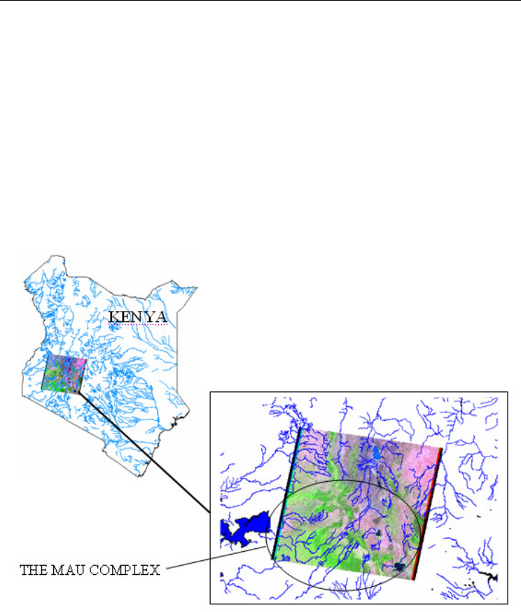
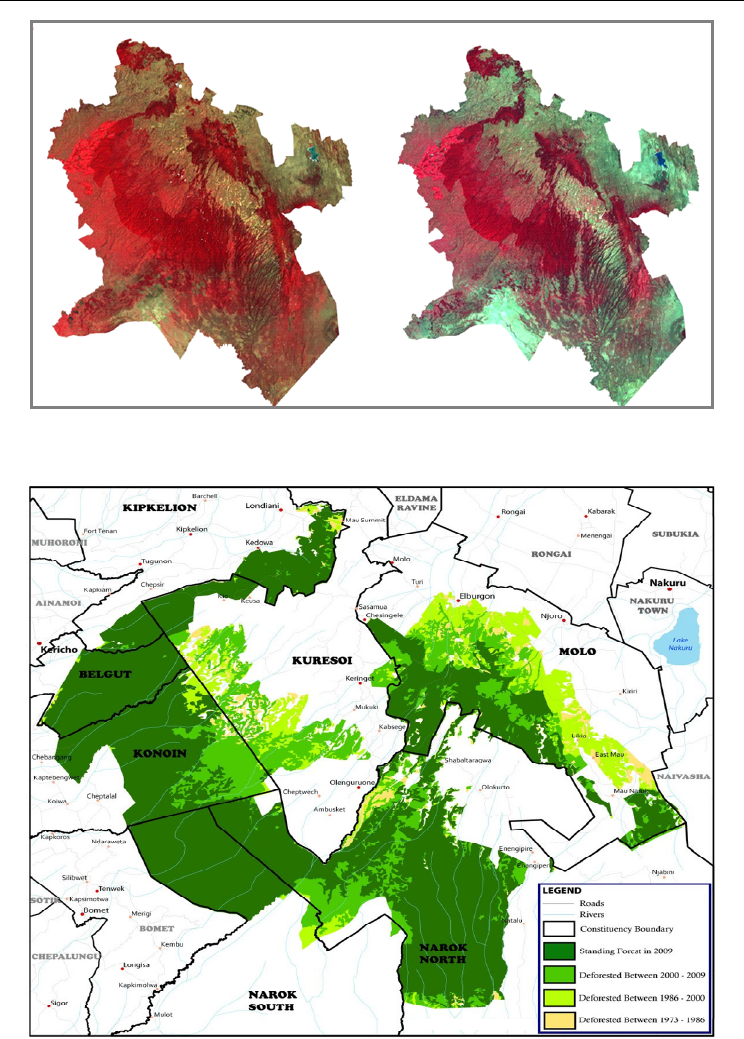
Digital Elevation Models (DEM) of the area. Figure 4 illustrates the integration of RS and
GIS that could be used for managing the MFC by using freely acquired images. The results
generally compared well to the reality despite the medium resolution of the images. With
further processing, supported by secondary datasets from high resolution satellite images, it
is possible to improve the quality of the derived stream-networks.
Fig. 4. Drainage network within the Mau Forest Complex.
3.3.2 Velocity and discharge
Normally, to elucidate the mechanisms driving discharge variability, a study period of not
less than 30 years is usually recommended. This period is considered long enough to discern
effects consequent of either land use changes or climate change and variability. Land use
change effects are commonly investigated by understanding the discharge regimes during
rainy seasons especially. Depending on the magnitude of the spatial changes however,
Environmental Monitoring
252
utmost care must be taken since studies in Kenya have also shown that the effects of land
cover change on runoff events tend to diminish with increased magnitude of storm events
(Olang & Fürst, 2011). Chemelil (1995) and Kundu et al. (2008) assessed the mean rainfall
and discharge characteristics of the Njoro River located in Eastern Mau to understand the
influence of environmental changes in the area. The authors used a similar procedure
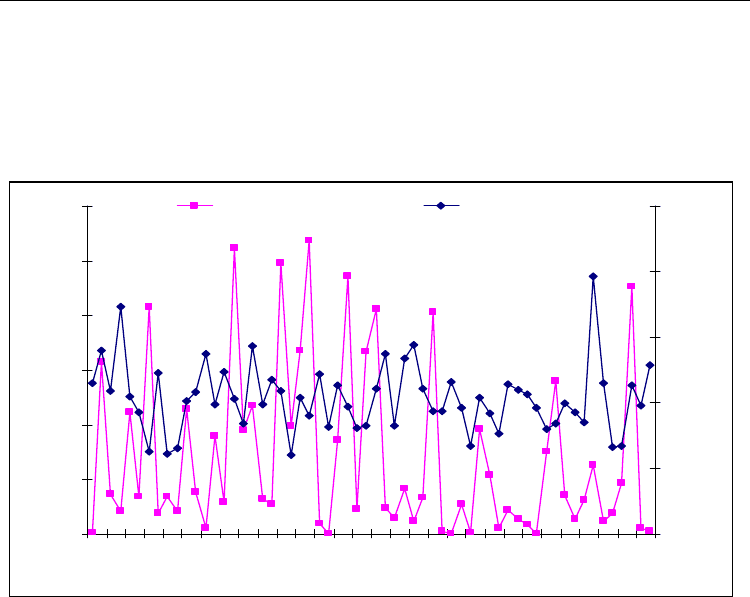
provided by Marcos et al. (2003). The results obtained are illustrated in Figure 5.
0
10
20
30
40
50
60
1944 1954 1964 1974 1984 1994
Time (years)
Discharge (m3/s)
0
500
1000
1500
2000
2500
Rainfall (mm)
Discharge (m3/s) Rainfall (mm)
Fig. 5. Long-term annual rainfall and discharge relationship between 1944 and 2001.
From the figure, discharges in the area showed a decreasing trend against a rather consistent
rainfall pattern. The frequency of low flow was noted to have increased, especially in the
interval between 1980 and 2000. This trend was largely attributed to the changing land use
patterns, considering that this period witnessed the highest human encroachment within the
MFC. It was hence more likely that the unplanned conversion of forest and woodlands into
agriculture and built up area within the headwaters could have influenced the discharge
generation processes and hydrological regimes of the area. Other reasons associated with
this were increased water abstraction for irrigation and domestic purposes consequent of the
rising population.
3.4 Land cover and land use
The Mau complex has the largest indigenous montane forest covering an area of about 2700
km
2
at present. Vegetation in the area varies largely from grasslands with scattered trees in
the plains, to shrubland and forests in the hilly uplands. In the higher mountain ranges,
bamboo forests are largely predominant. The vegetation around the rivers and lakes mainly
comprises of acacia trees and dense bush and shrubs. The escarpments are mainly wooded
and bushy with a wide ecological diversity. The higher areas comprise of forests with acacia
xanthophloea, Olea hochstetteri, Croton dichogamus, euphorbia candelabrum forest and bush land.
Previously, the area was largely covered by rich evergreen forests, extending from the
Land Degradation of the Mau Forest Complex: A Review for Management and Restoration
253
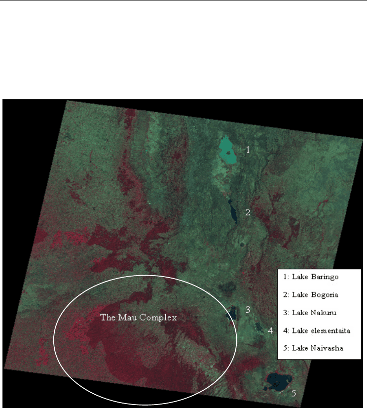
highlands of Mau hills, and woodland dominated by acacia trees in the plains. A Landsat
image (P169R60) in bands 4-3-2 for February 2000 showing the predominant vegetation and
land cover of the Mau complex are provided in Figure 6. The continuous deep red
represents highland vegetation on the escarpments and hill ranges. The green-blue patches
largely represent open pasture and grassland, bare soil, roads, built-up areas and farms after
harvesting.
Fig. 6. Landsat image for February 2000 showing Land cover and Rift Valley lakes.
Within the blocks of the MFC, the eastern Mau has witnessed most of the land use changes
consequent of the up-surging human population and their associated activities. The former
large scale farms have been subdivided and allocated to small scale farmers. For instance,
the former Sebiens (Ngondu) and Wright (Njokerio) large scale farms, which produced
flowers, wheat and dairy products on commercial basis, have been converted into small
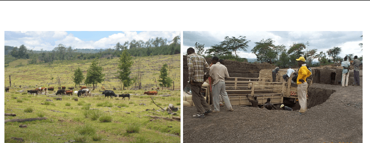
arable and grazing plots through the land fragmentation process. In Baruti area near Lake
Nakuru, a lunar landscape with the potential for landslide disasters during storm events has
been created by the haphazard and unplanned sand mining and quarrying activities carried
out in the area (Figures 7 (a) and (b)).
Environmental Monitoring
254
(a) (b)
Fig. 7. (a): Cleared forested presently used for grazing in Nessueit area (Photo taken in
2005 by Kundu) (b): Sand Harvesting at Baruti area near Lake Nakuru (Photo taken in
2009 by Kundu).
In eastern Mau, more than one-half of the cropland is set aside for subsistence farming.
Measures such as contour ploughing and conservation tillage that proved effective in soil
and water management have been receiving less and less attention. Consequently, a
majority of the land has become susceptible to soil erosion processes with the continued
degradation. Coupled with this is deteriorating water quality epitomized by the rising level
of dissolved nutrients (NO
3
and PO
4
), and eutrophication based processes, especially within
Lake Nakuru (Karanja et al., 1986; WWF, 1991; Chemelil, 1995; Shivoga, 2001; Owino et al.,
2005).
4. Land cover conversion patterns
Previous studies at the Regional Centre for Mapping of Resources for Development
(RCMRD) involving time series analysis of satellite based remote sensing data have
revealed significant land cover changes in the MFC (www.rcmrd.org) as shown in Figures
8 and 9. Before 1986, the dominant pre-change land cover types were about 75% of forests,
12% of woodlands and 13% of farms. By 1989, the landscape had changed tremendously
giving rise to about 60 % of forest and woodland, and 40 % of agriculture and built-up
area. Figure 8 illustrates deforestation patterns between 1986 and 2000. It should be noted
that the change statistics were obtained from classification of medium resolution spatial
datasets. Depending on the degree of spatial aggregation used during processing
therefore, it is likely that the dominant land cover types could have been overestimated at
the expense of non-dominant types. However, a ground survey carried out in retrospect
revealed that the classification trends generally compared well with the reality on the
ground. The dominant land cover types during the period were largely agriculture and
built-up area as per the classifications. The indigenous knowledge furthermore divulged
that the loss of forests were largely through clear-cut and progressive thinning by the
local residents.
Land Degradation of the Mau Forest Complex: A Review for Management and Restoration
255
Approx. area of
Forest cover: 435,072 Ha.
1986 2000
Approx. area of
Forest cover: 352,604 Ha.
Approx. area of
Forest cover: 435,072 Ha.
1986 2000
Approx. area of
Forest cover: 352,604 Ha.
Fig. 8. Deforestation patterns in the Mau complex between 1986 and 2000.
Fig. 9. Deforestation patterns of the MFC located south of Londiani (E. Khamala: 2009)

Environmental Monitoring
256
Further analysis using Landsat satellite images for the period between 1973 and 2009 have
revealed that the section of the forest falling south of Kipkelion and Londiani (Figure 9)
stood at about 254,100 hectares in 1973, 249,400 hectares in 1986, 226,100 hectares in 2000
and 179,000 hectares in 2009 (http://kenyafromspace.blogspot.com). Relative to 1973, these
figures represent percentage deforestation rates of about 2% between 1973and 1986, 11%
between 1973 and 2000, and 30% between 1973 and 2009. From the statistics, it could also be
deduced that deforestation rates were highest between 2000 and 2009, when about 47,100
hectares of forest were lost. These results generally conform to ground reality since this
period witnessed the highest excisions of the forest owing to the human encroachments and
settlements followed by irregular and ill planned forest resource exploitation.
5. The environmental impact of land use/cover change
The conversion of forest into agriculture and built-up land in the MFC has led to
noteworthy environmental impacts. Generally, increased impervious and hardened surface
areas such as roads, parking lots, sidewalks and rooftops diminishes infiltration based
processes and, consequently, recharge to the groundwater systems. These processes not only
impair the ability of the system to cleanse runoff and protect wetlands, but also amplify the
potential for soil erosion and floods, thereby contributing to the degradation of streams and
other water bodies. The replacement of forest and woodland by depletive subsistence
agriculture has also caused massive inflow of sediments into the nearby Lakes (Ramesh,
1998). The rising nutrient levels from the sediment have affected the growth of blue-green
algae (spirulina platensis), which forms the main food for flamingo birds, known to be a
major touristic attraction for Lake Nakuru. Apart from reduced revenues associated with
ecotourism in the area, the ecological effect of this has been the loss of biodiversity through
migration of the birds to other water bodies within the rift valley where complimentary
food is available. Conversion from forest to agriculture and grazing land has also disrupted
the hydrological cycle of the river drainage basins through increased evaporation and runoff
process, especially during rainy seasons.
Generally, low-productivity grass types from natural grassland pastures have lesser leaf
area and produce a smaller amount of biomass compared to the forested vegetation. With
reduced leaf area and biomass consequent of the land degradation, rainfall interception and
surface detention capacity are bound to significantly decrease. This reduces the soil
moisture retention capacities, further contributing to the decline in the general
evapotranspiration rates (ET
o
) of the area. Changes in land use may also affect the
groundwater recharge of a system. This however, depends on the groundwater recharge
area, which may be different from the surface water catchments. However, studies have also
shown that logging or conversion of forest to grassland for grazing can result into rising
water table as a result of decreased evapotranspiration. In some cases, the water table may
fall as a result of decreased soil infiltration from soil compaction and non-conservation
farming techniques. If the infiltration capacity is substantially reduced, the long term effect
can be severe cases of drought and desertification (Maidment, 1993; Chemelil, 1995).
Removal of forest from a catchment can also cause significant hydrologic consequences such
as decreased rainfall interception leading to variations in the stream water quality and
quantity (Mutua and Klik, 2007; Olang et al., 2011). Research has shown that tree canopies
can intercept 10-40% of incoming precipitation depending on the age, location and density
of stand, tree species, rainfall intensity and evaporation rates. Land degradation due to
Land Degradation of the Mau Forest Complex: A Review for Management and Restoration
257
forest logging, forest fires and wind damage can therefore have major and long lasting
effects upon the canopy characteristics and consequently, overall hydrological response of
an area. Clearing of forests can also cause habitat fragmentation, loss of biodiversity and
water related pollution problems.
From a macro-scale perspective however, deforestation as a problem to society is still
complex in nature. However, there is no question as to whether deforestation affects the
climate system dynamics, atmospheric composition and other ecosystem processes. In the
tropical regions, observational studies on the effects of land cover conversions on the
climate and hydrology of very large basins greater than 100,000 km
2
are still scarce. The few
large-scale catchment-based studies available have found no consistent relation between
land cover degradation and climate changes. The studies further suggests that if appropriate
land cover, precipitation, and discharge data were available in time and space, then perhaps
it would be possible to determine whether the impact of land cover change across very large
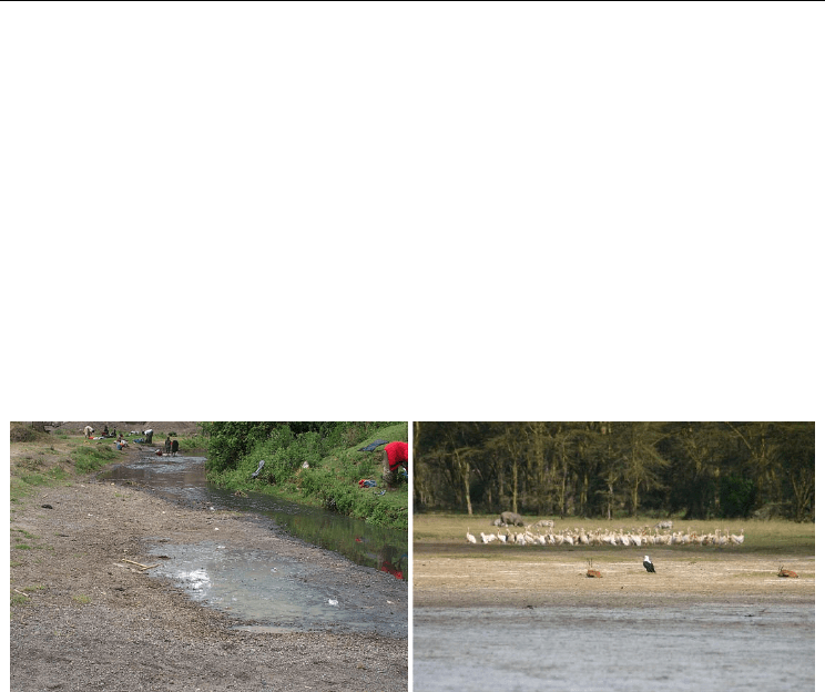
catchments is similar to that observed in smaller catchments. Figure 10 illustrates the impact
of land cover changes of the Mau on the ecology of river Njoro (a) and Lake Nakuru (b).
(a) (b)
Fig. 10 (a): Drying river bed at Baruti area (b): Retreating water levels in Lake Nakuru
(photos taken by Kundu in 2009).
6. Environmental conservation strategies
More recently, the Mau Forest Complex has received considerable attention from local and
international organizations due to its ecological significance, which is posing a threat to the
whole region. In Kenya, most forest areas are now under the management of the Kenya
Forest Service (KFS), which has made substantial steps towards addressing the degradation
and deforestation threat to all the major water towers. Among the steps is the new forest
policy and law, which were promulgated in 2005. The new law lays emphasis on a
participative approach to management of forest resources by all stake holders including
local communities and the private sector. A further step is the creation of the Task Force for
the Mau Forest Complex (TF-MFC) under the office of the Prime Minister of Kenya, with the
mandate to recommend strategies for restoring the forest complex in line with Vision 2030.
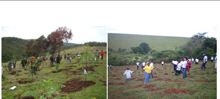
A very important and urgent scheme is the reforestation and restoration through tree
planting as shown in Figure 11. Such activities are organized by the concerned
Environmental Monitoring
258
governmental chief officers, in collaboration with environmental non-governmental
organizations and international organizations.
(a) (b)
Fig. 11. (a): Restoration of the Enderit Block of the Eastern Mau Forest Reserve
(b): Tree planting to restore the forest covers (Photo taken by Kundu in 2010).
A number of international and sub-regional organizations are involved in the conservation
and rehabilitation planning. The major international programme is under the
UNEP/DEWA, which is also involved in the assessment of the threats to critical montane
forests in East Africa including Mt. Kenya, Aberdare range and Mt. Kilimanjaro. Other
organizations which have shown interest, directly or indirectly, include the Africa
Convention for the Conservation of Nature and Natural Resources (2003), East Africa
Community Treaty (1999), Convention on Wetlands of International Importance Especially
as Waterfowl Habitat (Ramsar Convention, 1971), Convention on Biological Diversity (1992),
International Tropical Timber Agreement (1983, revised 1994) United Nations Forum on
Forests, Intergovernmental Authority on Development (IGAD), Johannesburg Plan of
Implementation of the World Summit on Sustainable Development (WSSD), Lake Victoria
Protocol (2003), Protocol for Environment and Natural Resources, The United Nations
Framework Convention on Climate Change (1992), the World Heritage Convention (1972),
the United Nations Convention to Combat Desertification (UNCCD) (1994); the Convention
on International Trade in Endangered Species (CITES, 1973), The United Nations
Convention to Combat Desertification (UNCCD) (1994), The Nile Basin Initiative (NBI)
amongst others. So far under the TF-MFC mandated with co-coordinating the rehabilitation
planning of the Mau ecosystem, a number of strategic options have been proposed and
realized, in part. The major key interventions were categorized into three phases. Phase 1
involves short term options achievable within the first three years. Phases 2 and 3 involve
medium and long term interventions aimed at consolidating the management efforts for
sustainability reasons. Among the key interventions, the first and second phases include:
Development of effective institutional framework and strategic Management Plan
Under this framework, a Mau Forests Complex Authority (MFCA) was to be established to
coordinate and oversee the management of the complex. The authority was to be guided by
board of directors comprising representatives of the main stakeholders, including the
economic sectors directly dependent on the goods and services of the Mau Forests Complex
such as water, energy, tourism and wildlife, agriculture and forestry. Ecological

Land Degradation of the Mau Forest Complex: A Review for Management and Restoration
259
requirements, in conformity with the needs of existing strategic plans, including for Vision
2030 were to be integrated in the development plan. The current status of the Mau
ecosystem, including the existing data status for management purposes were to be
considered in achieving this. Additionally is the need for assessment studies on the critical
catchment areas and biodiversity hotspots, which require immediate and appropriate
conservation strategies.
Boundary surveys, issuance of title deeds and monitoring and enforcement
This was to involve the demarcation of the legal boundaries and assessment of the critical
water catchment areas, assessment of vegetation cover status and biological diversity
hotspots in the MFC. Furthermore was the need for routine monitoring to prevent new
encroachment, charcoal burning and tree felling that could further attenuate degradation
process. Demarcation and fencing of hydrological and biological hotspots or where
significant human-wildlife conflicts could occur was hence imperative in this context.
Relocation, resettlement and livelihood support and development
This activity involved the relocation of all people living in the demarcated protected forests.
In the event of resettlement thus, the government was to provide alternative land and funds
for the development of the new lands, and livelihoods, while taking into consideration
vulnerability of the people within the locations. Immediate livelihood support including
water, food, shelter and energy were hence required for the families relocated from the
complex to lessen the resentment felt by those aggrieved by their relocation.
Public awareness and community sensitization
The activity was mainly to address the needs of the local communities living around the
forest. The restoration process was to be done in consultation with local communities, who
were to benefit both through directly employment opportunities and/or indirectly through
ecosystem services including water provision through a restored ecosystem. Sustainable
livelihood options in the forest, with particular emphasis on employment opportunities and
natural resource based income generating activities were to be explored. This was to
include, but not limited to, raising most of the required seedlings for rehabilitation, with the
balance being produced through institutional nurseries through technical support by private
and international organizations.
7. Conclusions
The negative environmental impacts on the MFC, have reached crisis level. Presently, the
riparian communities and the Kenya government through key economic sectors that directly
depend on goods and services of the region are paying the price of over three decades of
negligence and improper land use management. The ongoing restoration efforts, including
educating the general public about the need for sustainable environmental conservation in
such areas is highly essential and should be sustained. It is imperative that the restoration
and rehabilitation efforts are fortified through integration with potential socio-economic
activities that can support the survival of the riparian rural communities. Exploring the role
of eco-tourism, in relation to natural forested ecosystem, followed by putting in place
appropriate and sustainable management framework are hence important in this respect. In
order to further support the rural communities it is crucial to initiate long-term agro-forestry
based practices such as production of sustainable wood products, and non-timber products
such as medicinal plants and honey for commercialization purposes.

Environmental Monitoring
260
Also, worth mentioning as a fundamental aspect of the conservation would be the
unavoidable role of continued research in the region. Further studies that go hand in hand
with the restoration and rehabilitation process would be a key support tool that enables
necessary and appropriate adjustment as need arises. Evaluating the interactions of the
rehabilitated forest ecology in relation with the biological and hydrological systems will be
important at every stage. With the increasing advancement in RS techniques, future research
activities aimed at exploring new and innovative methods for environmental monitoring
and management are also imperative in this respect. Other studies related to carbon
sequestration to defer the effects of global warming through Reduced Emissions associated
with Deforestation and Degradation (REDD) are also necessary. Considering that land
degradation due to anthropogenic causes still remains a major threat to ecosystems and
natural resource sustainability in Kenya, successful rehabilitation of the Mau Forest
Complex will offer a good prototype that can be studied and possibly emulated across other
regions experiencing similar environmental challenges.
8. Acknowledgements
The authors would like to acknowledge the support of the relevant authorities at the World
Agro-forestry Centre, Regional Centre for Mapping of Resources for Development, Regional
Disaster Management Center of Excellence and IGAD – Climate Prediction and Application
Centre. Our Sincere gratitude also goes to the editorial team at InTech Publishers for
streamlining this work to publication standards.
9. References
Baldyga, T. J., Miller, N. S., Driesse, L. K., & Gichaba, N. C. (2007). Assessing land cover
change in Kenya’s Mau Forest region using remotely sensed data. African Journal of
Ecology, 46, 46–54, doi:10.1111/j.1365-2028.2007.00806.x
Batjes, N. H. & Gicheru, P. (2004) Soils data derived from SOTER for studies of carbon stocks
and change in Kenya (Version 1). World Soil Information (ISRIC) GEF-SOC/VROM
project report no. 2004/01 (February 2004).
Borga, M. (2002). Accuracy of radar rainfall estimates for streamflow simulation. Journal of
Hydrology, 267, 26-39.
Calder I.R. (1998). Water-resource and land use issues. SWIM Paper 3. Colombo: IIMI
Chemelil, M.C. (1995). The effect of human induced watershed changes on stream flows.
PhD Thesis, Loughborough University of Technology, UK.
China, S.S. (1993). Land Use Planning using GIS. Unpublished PhD thesis, University of
Southampton
Coppin P., Jonckheere, I., Nackaerts, K., & Muys, B. (2004). Digital change detection
methods in ecosystem monitoring: a review. International Journal of Remote Sensing,
25, 1565-1596.
Corey, J. A. B., Navjot, S. S., Kelvin, S-HP. & Barry, W. B. (2007). Global evidence that
deforestation amplifies flood risk and severity in the developing world. Global
Change Biology, 13, 2379–2395, doi:10.1111/j.1365-2486.2007.01446.x
FAO. (1998). Food and Agriculture Organization of the United Nations. Crop
evapotranspiration: Guidelines for computing crop water requirements - FAO
Irrigation and drainage paper 56, Rome, Italy.