Ekundayo E.O. Environmental monitoring
Подождите немного. Документ загружается.


Land Degradation of the Mau Forest Complex: A Review for Management and Restoration
261
FAO. (2009). Food and Agriculture Organization of the United Nations. Crop
evapotranspiration: Guidelines for computing crop water requirements - FAO
Irrigation and drainage paper 56, Rome, Italy.
FAO-UNESCO. (1988) Soil Map of the World, Revised Legend. FAO World Soil Resources
report no. 60. Food and Agricultural Organization of the United Nations, UNESCO,
Rome, Italy.
Foody, G. M. (2001). Monitoring the magnitude of land cover change on the southern limits
of the Sahara. Photogrammetric Engineering and Remote Sensing, 67(7), 841-847.
http://www.isric.org/isric/webdocs.Docs/ISRIC_Report_2004_01.pdf.
ISRIC/FAO-UN. (1995). Procedures for Soil Analysis. Technical Paper 9. (5th edition).
Jensen, J. R. (2000). Remote Sensing of the Environment: an earth resource perspective.
Prentice Hall series in geographic information science. Upper Saddle River, NJ,
USA
Jensen, J. R., 2005. Introductory Digital Image Processing: A Remote Sensing Perspective (3
rd
edition). Prentice Hall series in geographic information science. Upper Saddle
River, NJ, USA.
Karanja, A., China, S. S. & Kundu, P. M.(1986). The influence of land use on the Njoro River
Catchment between 1975 and 1985. In: Soil and Water Conservation in Kenya -
University of Nairobi, Nairobi, Kenya.
KFWG. (2001). Kenya Forests Working Group. Excision and settlement in the Mau Forest.
Report of Kenya Forest Working Group, Nairobi, Kenya, pp.15.
King, L.A. & Hood, V. L. (1999) Ecosystems health and sustainable communities: north and
south. Ecosystem Health, 5, 49–57.
Krajewski, W. F. & Smith, J. A. (2002). Radar hydrology: rainfall estimation. Advances in
Water Resources, 25(8), 1387-1394.
Krhoda, G. O. (1988). The impact of resource utilization on the hydrology of the Mau Hills
forest in Kenya. Mt. Resources Development, 8, 193–200.
Kundu P. M., China S. S. & Chemelil, M. C. (2008). Automated extraction of morphologic
and hydrologic properties for River Njoro catchment in Eastern Mau, Kenya.
Journal of Science, Technology, Education and Management, 1 (2), 14-27
Kundu, P. M.(2007). Application of remote sensing and GIS techniques to evaluate the
impact of land use and land cover change on stream flows: The case for River Njoro
catchment in eastern Mau-Kenya. PhD Thesis. Egerton University, Kenya.
Liu, D., Mausel, P. Brondizio, E. & Moran, E. (2004). Change detection techniques.
International Journal of Remote Sensing, 25, 2365-2401.
Maidment, D. R. (1993). Handbook of hydrology. McGraw Hill, New York, San Francisco,
USA.
Marcos, H. C., Aurelie, B. & Jeffrey, A.C. (2003). Effects of large-scale changes in land cover
on the discharge of the Tocantins River, Southeastern Amazonia. Journal of
Hydrology, 283, 206-217.
Mutua B. M. & Klik, A. (2007). Predicting daily streamflow in ungauged rural catchments:
the case of Masinga catchment, Kenya. Hydrological Sciences, 52(2), 292-304.
Olang L.O., Kundu P. M, Bauer T. & Fürst, J. (2011). Analysis of spatio-temporal land cover
change for hydrological impact analysis within the Nyando River basin of Kenya.
Environmental Monitoring and Assessment (Springer), 179, 389–401,
doi::10.1007/s10661-010-1743-6.

Environmental Monitoring
262
Olang, L. O. & Fürst, J. (2011). Effects of land cover change on flood peak discharges and
runoff volumes: model estimates for the Nyando River Basin, Kenya. Hydrological
Processes, 25, 80–89, doi:10.1002/hyp.7821.
Olang, L. O. (2009) Analysis of land cover change impact on flood events using remote
sensing, GIS and hydrological models. A case study of the Nyando River Basin in
Kenya. Dissertation, University of Natural Resources and Applied Life Sciences
(BOKU) of Viena, Vienna, Austria.
Owido, S. F. O, Chemelil, C. M., Nyawade, F. O. & Obadha, W. O. (2003). Effects of Induced
Soil compaction on Bean (Phaseolus Vagaries) Seedling Emergence from a Haplic
phaeozen soil. Agricultura Tropica. ET subtropica, 36, 65-69.
Owino, J., Owido, S. F. O. & Chemelil, C. M. (2005). Nutrients in runoff from a clay loam soil
protected by narrow grass strips. Journal of Soil and Tillage Research (Elsevier), 88,
116-122.
Pellikka, P., Clark, B., Hurskainen, P., Keskinen, A., Lanne, M., Masalin, K., Nyman-
Ghezelbash P. & Sirviö, T. (2004). Land Use change monitoring applying
Geographic Information Systems in the Taita Hills, SE-Kenya. In: Proceeding of the
5th African Association of Remote Sensing of Environment Conference, Nairobi,
Kenya.
Rambaldi, G., Muchemi, J., Crawhall, N. & Monaci, L. (2007). Through the Eyes of Hunter-
Gatherer: Participatory 3D modelling among Ogiek indigenous peoples in Kenya.
Information Development, 23(2-3), 113-128, doi:10.1177/0266666907078592.
Ramesh, T.(1998). Lake Nakuru Ramsar Project. World Wide Fund for Nature (WWF)
(www.aaas.org/international/ehn/biod/thampy.htm)
Refsgaard, J. C. & Henriksen, H. J. (2004). Modelling guidelines––terminology and guiding
principles. Advances in Water Resources, 27, 71–82, doi:10.1016/j.advwatres.2003.08.006
Shivoga, W. A. (2001). The influence of hydrology on the structure of invertebrate
communities in two streams flowing into Lake Nakuru, Kenya. Hydrobiologia, 458,
121-130.
Sombroek, W. G.,. Braun, H. M. H. & van der Pouw, B. J. A. (1980). The explanatory soil map
and agro-climatic zone map of Kenya. Report No. E.1, Kenya Soil Survey, Nairobi,
Kenya.
World Resources Institute. (2007). Nature’s Benefits in Kenya: An Atlas of Ecosystems and
Human Well-Being. Washington, DC, USA.
WWF (World Wide Fund for Nature). (1991). Conserving Africa’s elephants: current issues
and priorities for action. (eds. H.T. Dublin, T.O. McShane and J. Newby) , WWF
International, 1196 Gland, Switzerland.
16
Concepts for Environmental
Radioactive Air Sampling and Monitoring
J. Matthew Barnett
Pacific Northwest National Laboratory,
United States of America
1. Introduction
Environmental radioactive air sampling and monitoring is becoming increasingly important
as regulatory agencies promulgate requirements for the measurement and quantification of
radioactive contaminants. While researchers add to the growing body of knowledge in this
area (Byrnes, 2001; Till & Grogan, 2008), events such as earthquakes and tsunamis
demonstrate how nuclear systems can be compromised. The result is the need for adequate
environmental monitoring to assure the public of their safety and to assist emergency
workers in their response. Two forms of radioactive air monitoring include direct effluent
measurements and environmental surveillance.
Direct effluent radioactive air sampling is typically conducted at the exhaust point. The
considerations for analysis should include particulates and gases in use; one cannot neglect
short-lived radioisotopes or hard-to-detect (HTD) radionuclides. An emission point may be
in the form of an actively exhausted stack or vent. Emissions may come from several
industries, such as medical isotope production, hospital use, research institutes, and
industrial processes.
Environmental surveillance is conducted when emissions emanate from a fugitive pathway
such as a waste pile, abandoned building, or contaminated land mass or breather tank.
Monitoring stations are often located at near the facility boundary or nearby public areas in
the affected directions. Often, a combination of direct effluent (point source) sampling and
post release environmental monitoring is employed to assure the public, demonstrate low
emissions of radioactive material, and comply with regulations.
This chapter presents basic concepts for direct effluent sampling and environmental
surveillance of radioactive air emissions, including information on establishing the basis for
sampling and/or monitoring, criteria for sampling media and sample analysis, reporting
and compliance, and continual improvement.
2. Basis for sampling and/or monitoring
Releases of airborne radionuclides into the environment are typically managed so that they
are minimized, utilizing the As Low As Reasonably Achievable (ALARA) concept. These
releases encourage the need to demonstrate that the environment is protected, which is
usually accomplished through direct effluent sampling at the point of exhaust and/or
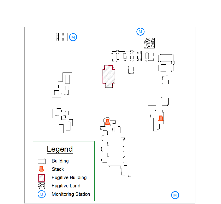
through environmental surveillance at locations both on and off the site (Fig. 1). A
Environmental Monitoring
264
combination of both methods may be employed depending on the facility needs and
regulatory requirements.
Fig. 1. Example facility showing stacks, fugitive emissions, and on-site monitoring station
locations
Exposure to humans from the release of radioactive materials into the atmosphere would
generally occur through the inhalation or ingestion pathway; an open wound would be
another possible way for internal deposition. Additional exposure comes from immersion,
material deposited on the soil and vegetation, and through the resuspension of material
when disturbed. Hence, the categories for consideration in establishing radioactive air
sampling systems include particulate radionuclides, gases (e.g., tritium and carbon-14), and
special categories such as radioiodines and other HTD radionuclides (e.g., those with a short
half-life or very weak radiation emission). In-depth implementation methods are available
in established standards such as Sampling Airborne Radioactive Materials From the Stacks and
Ducts of Nuclear Facilities (International Organization for Standardization [ISO], 2010) and
Sampling and Monitoring Releases of Airborne Radioactive Substances From the Stacks and Ducts of
Nuclear Facilities (American National Standards Institute [ANSI], 2011) as well as in
Radioactive Air Sampling Methods (Maiello & Hoover, 2010). When sampling/monitoring is
not conducted, releases may be estimated.

Concepts for Environmental Radioactive Air Sampling and Monitoring
265
2.1 Sampling point source releases of radioactive substances
Over 40 years ago, proscriptive sampling methods were normative, with an emphasis on
the isokinetic sampling of airborne radioactive material from exhaust points (ANSI, 1970).
Since then, advances in sampling techniques and improved technology have yielded a
new approach to representative sampling (ANSI, 2011; ISO, 2010). Because of these
advances, the goal of achieving an unbiased, representative sample now results in a
standards-based approach with definitive criteria to establish the sampling at a well-
mixed location.
Point sources are discrete, well-defined locations (such as a stack, vent, or other functionally
equivalent structure) from which radioactive air emissions originate (Washington
Administrative Code [WAC], 2005; U.S. Environmental Protection Agency [EPA], 2002a).
Point sources are actively ventilated or exhausted. Emissions from a point source may be
captured, treated, monitored, sampled, and/or controlled. At some threshold, direct effluent
sampling must be conducted to verify low emissions, and a graded approach based on
potential emissions is recommended. Table 1 shows the ANSI N13.1-2011 approach to direct
effluent sampling and monitoring requirements based on the U.S. limit of 0.1 mSv/yr
(10 mrem/yr) (EPA, 2002a).
Potential
Impact
Category
Monitoring and Sample Analysis Procedures
Potential Fraction of
Allowable Limit
1
Continuous sampling for a record of emissions and
in-line, real-time monitoring with alarm capability;
consideration of separate accident monitoring
system
>0.5
2
Continuous sampling for record of emissions, with
retrospective, off-line periodic analysis
>0.01 and ≤0.5
3
Periodic confirmatory sampling and off-line
analysis
>0.0001 and ≤0.01
4
Annual administrative review of facility uses to
confirm absence of radioactive materials in forms
and quantities not conforming to prescribed
specifications and limits
≤0.0001
Table 1. Graded approach to sampling and monitoring (ANSI N13.1-2011)
Using a graded approach to determine direct effluent sampling and monitoring needs
(Table 1) and to design a robust sampling system (whereby the sample is extracted at a
homogeneous location within the point source) requires an evaluation of the sample
environment, transport mechanisms, and collection materials. The criteria for the
homogeneous sampling location includes a determination of the angular or cyclonic flow,
uniformity of the air velocity profile, gas concentration profile, and particle concentration
profile (ISO, 2010; Table 2). Scaled tests may be utilized to demonstrate compliance with
these criteria; however, as technology improves, modeling techniques such as
computational fluid dynamics may be used to validate a well-mixed location without the
necessity of field tests conducted in the stack or vent (Recknagle et al., 2009).

Environmental Monitoring
266
Characteristic Methodology Recommendations
Measurement to
determine if flow in
a stack or duct is
cyclonic
ISO 10780:1994.
The average resultant flow angle
should be less than 20 degrees.
Velocity profile
Selection of points across a section
based on the guidance in ISO
10780 for the center 2/3 of the
area may be added to adequately
cover the region.
The coefficient of variance (COV)
should not exceed 20% over the
center region of the stack that
encompasses at least 2/3 of the
stack cross-sectional area.
Tracer gas
concentration
profiles
Selection of points across a section
based on the guidance in ISO
10780 for the center 2/3 of the
area of the stack or duct.
Additional points or area may be
added to cover the region
adequately.
The COV should not exceed 20%
over the center region of the stack
that encompasses at least 2/3 of
the stack cross-sectional area.
Maximum tracer
g
as
concentration
deviations
Selection of points across a section
based on the guidance in ISO
10780 for the entire cross-sectional
area.
At no point on the measurement
grid should the tracer gas
concentration differ from the mean
value by more than 30%.
Aerosol particle
concentration
profile
Selection of points across a section
based on the guidance in ISO
10780. Additional points or area
may be added to cover the region
adequately.
The COV should not exceed 20%
over the center region of the stack
that encompasses at least 2/3 of
the stack cross-sectional area.
Table 2. Summary of recommendations for a stack sampling location (ISO 2889:2010)
2.1.1 Direct effluent sampling
Once the sampling location has been identified and qualified, attention to the sample system
design is necessary. A typical stack effluent sampling system includes an in-line sample
probe within the stack/vent, a sample transport line to the sample media (e.g., filter paper
or cartridge), a rotameter, and vacuum gauge with feedback controls. The sample collection
and transport are affected by the nozzle design, performance, and specific sampling use
(e.g., particulates, gases/vapors). For reporting purposes, the bulk stream flow through the
emission point is also required.
During the sampling process, losses – particle losses in particular – should be minimized.
The most effective way to accomplish this is to limit the number of bends and horizontal
sections of the sample line and to minimize the total sample line length. For harsh sampling
environments such as those containing corrosive gases and vapors, construction material
should be resistant to degradation. Because some loss is inevitable, required maintenance
activities such as inspection, cleaning, and testing can help maintain effective operations.
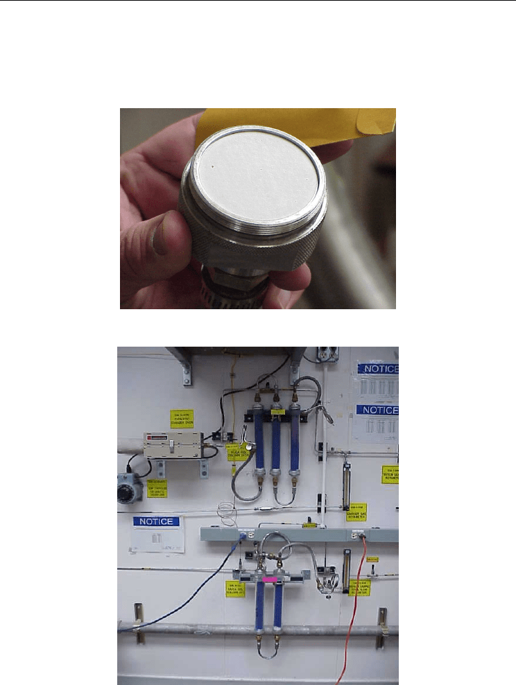
The collection media is equally important to obtaining a valid sample. Sampler filters are
usually adequate for collecting particulate radioactive air media (Fig. 2). Commercial
particulate filters are made of glass fiber, acrylic copolymer, or other robust material and
vary in size from 25 mm to 20 cm in diameter. Other potentially necessary specialized
Concepts for Environmental Radioactive Air Sampling and Monitoring
267
collection media include silica gel (Fig. 3) or molecular sieves for tritium collection, activated
charcoal or silver zeolite cartridges for radioiodines, and bubblers for other gases. For
collection media selection, detection criteria for the measurement of alpha, beta, and gamma
radiation must also be established to meet lower limits of detection. The sample volume
affects the criteria for detection limits, sample size, sampling frequency, and materials used.
Fig. 2. Fixed head radioactive air stack sampler with 47-mm diameter filter in place
Fig. 3. Silica gel columns in use for tritium sampling system; three columns are used for
collecting water vapors, and then the dry gas goes through a catalyst to form the water
vapor collected using the two columns (Barnett et al., 2004)
Environmental Monitoring
268
Optimization of the sampling system is the final component of the program development.
Balancing the effects and requirements along with a graded approach will generally result
in an adequate sample. These considerations are also germane to environmental surveillance
sample collection stations and equipment.
2.1.2 Direct effluent monitoring
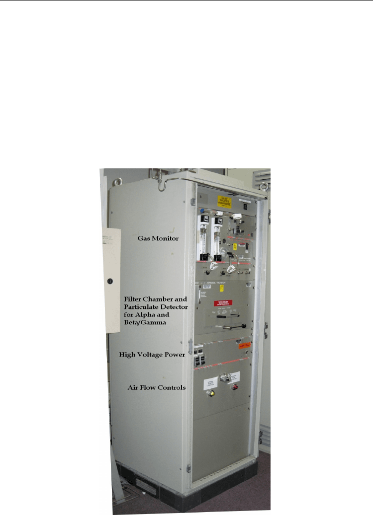
As identified in the graded approach of Table 1, continuous air monitoring may be required
at a point source for real-time analysis and feedback. A continuous air monitor (CAM)
provides timeliness in assessing the release of radionuclides to the environment. Fig. 4
shows a combination particulate and gas CAM. While the system specifications require the
user to balance the sensitivity, energy response, response time, and accuracy, the CAM
should also have alarm capabilities with established thresholds to alert the user to
significant releases (DOE, 1991).
Fig. 4. Combination continuous air monitor for particulates and gases

Concepts for Environmental Radioactive Air Sampling and Monitoring
269
The requirements of sampling at a well-mixed location apply equally to a stack CAM.
However, additional maintenance, repair, and calibration are required for a CAM.
Maintenance activities can include periodic checks of the system responses to inputs that
generate alarms that verify normal operations. Repairs can include replacement of
electronics, detectors, or other system components that wear out or become damaged.
Finally, an annual calibration is required that covers all aspects of the CAM operations.
Calibration activities would include background checks and measurements, source
responses to reference standards of given radioisotopes, leak tests, electronics validations,
and alarm responses.
A CAM is particularly useful in laboratory work where releases are expected and can be
observed and managed, either in normal or upset/accident conditions. For routine work,
staff may observe a release to limit the overall activity or bound daily releases. In an upset
condition, staff have a near real-time assessment of releases and potentially a second filter
for future analysis to confirm releases and potential exposures.
2.2 Airborne radioactive material environmental surveillance
The primary benefits of environmental surveillance for airborne radioactive material are
that it identifies emissions from fugitive (and point) sources and provides detailed impacts
to the public and the environment. When establishing a site monitoring program, utilization
of a data quality objective (DQO) process is recommended, this determines the
environmental monitoring needs for routine radiological air emissions to the atmosphere
from the emissions/sources of the site in response to regulatory requirements. Assistance
with preparing a DQO is available from Guidance on Systematic Planning Using the Data
Quality Objective Process (EPA, 2006); additionally, the Pacific Northwest National
Laboratory (PNNL) used the DQO process to establish three site monitoring locations
(Barnett et al., 2010). The development of the DQO includes the following aspects:
1. Stating the problem
2. Establishing goals
3. Assessing inputs
4. Setting boundaries
5. Establishing decision rules
6. Evaluating decision errors
7. Optimizing the results
Besides a DQO, processes such as an implementation plan, sampling and analysis plan, a
site environmental monitoring plan, and a data management plan complete a well-managed
monitoring program.
Identifying and clearly stating the problem is the first step in the DQO process. This section
discusses the background and scope, states the requirements, establishes the problem
statement, and identifies the participants and schedule. Once the problem statement is
firmly established, the goals of the DQO can be identified, usually a series of supportive
questions and actions that specifically address the problem statement.
Assessing inputs and setting boundaries are the next steps in the DQO process. The inputs
are used to answer the questions formulated from the goals; include information necessary
to meet performance and acceptance criteria; and provide direction for the monitoring,
sampling, and analysis methods. Additionally, the boundaries discuss the logistics of
implementing the goals and objectives. To provide a viable monitoring program, all seven
aspects of a DQO must be considered.
Environmental Monitoring
270
In establishing and evaluating the decision rules and errors, goals and inputs are vital. The
decision rules are the answers to questions posed during the goal-setting process, and they
utilize the data inputs for the decisions that follow. Decision errors evaluate and discuss
potentially incorrect decisions and determine the possible consequences.
The final step in setting up the monitoring program for a facility or site is optimization,
which may include requirement compliance, using commercial off-the-shelf equipment, and
implementing standard analytical methods. However, when optimized, the goal is to make
the operations and systems work efficiently.
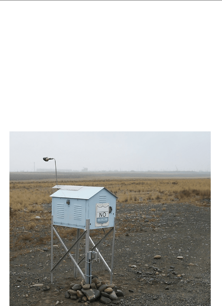
Commercial monitoring stations are readily available (Fig. 5), the weather-protected
equipment is housed in a small metal portable or stationary cabinet consisting of a pump,
flow totalizer, adjustable vacuum gauge, and other equipment and/or electronics as
necessary (Fig. 6). The unit’s power may be a hard-wired electrical outlet, batteries, or a
renewal energy source such as an array of solar panels.
Depending on system and design needs, the filter/sample media may be either inside the
monitoring cabinet or external to it. Basic filter papers (Fig. 2) can be fixed to a sample head
on the exterior of the cabinet; cartridges (e.g., silver impregnated zeolite and/or activated
carbon) can also be fixed to an exterior sample head. Other sample media such as the larger
silica gel cartridges may need to be housed inside the cabinet.
Fig. 5. Environmental air monitoring station