Myron G. Best. Igneous and metamorphic 2003 Blackwell Science
Подождите немного. Документ загружается.

2. Thoroughly hydrated and extensively carbonated
mafic and ultramafic rocks were apparently created
by metasomatism in a subaqueous environment;
this does not necessarily imply reconstitution at
spreading ridges as in modern settings.
3. Metamorphism is commonly polyphase and some
of the multiple episodes are in contact aureoles
around granitoid intrusions.
4. Thermobarometers in mineral assemblages of well
studied belts indicate significant regional contrasts
in P and T of mineral equilibration resulting from
variations in tectonic and/or magmatic thickening
and depth of burial, followed by erosional and tec-
tonic uplift.
5. Archean granitoid–greenstone terranes have low to
intermediate P/T metamorphic field gradients.
The absence in early Precambrian rocks of high P/T
field gradients and associated distinctive minerals, such
as lawsonite, aragonite, jadeite, and so on, has been
recognized for several decades. Possible reasons for
their absence include a lack of preservation resulting
from preferential erosion, subsequent overprinting by
higher-T metamorphism, or unfavorable thermotec-
tonic conditions in the hotter infant Earth (Windley,
1995, p. 324). The oldest known high P/T rocks appear
to be multiply deformed metasedimentary rocks that
are of transitional blueschist–greenschist facies uncon-
formably underlying 800 Ma unmetamorphosed sedi-
mentary rocks in northwestern China (Liou et al.,
1989). For some time, the oldest known subduction-
related high-P eclogites were those that formed at
1000–1100 Ma in a subduction setting near Glen Elg,
Scotland. But Möller et al. (1995) described eclogites
and associated metapelites equilibrated at 18 kbar
and about 750°C in a 2000 Ma paleosubduction zone
bordering an Archean craton in Tanzania.
Mineralization is widespread in greenstone belts
and has provided much of the impetus and funding
for the investigation of their overall geology. Economic
resources include stratified Fe formations, Au–quartz
lodes, massive and disseminated Cu–Zn–Pb sulfides,
and, especially in ultramafic host rocks, valuable con-
centrations of Ni, Cu, Pt, Pd, Cr, V, and asbestos.
19.2.2 Itsaq Gneiss Complex, West Greenland:
Earliest Record of Crustal Process at 3900–3600 Ma
West Greenland (Figure 19.2) harbors the largest
(3000 km
2
) and best exposed remnant of oldest crustal
rocks on Earth—the Itsaq Gneiss Complex (Nutman
et al., 1996). In this complex, the Isua supracrustal se-
quence is the earliest record of lithosphere–hydrosphere
interaction on the planet and includes 3850 Ma
carbon-bearing rocks that are claimed by some invest-
igators to represent the earliest record of biological
activity (Myers and Crowley, 2000).
All of the Isua sequence has been metamorphosed
to the granulite and amphibolite facies, which is an
unusually high grade for TTG–greenstone terranes.
Additionally, the sequence is complexly deformed and
variably metasomatized. Appraisal of protoliths has,
accordingly, been equivocal. Calc–silicate rocks that
were formerly believed to be metamorphosed impure
limestones have been reinterpreted by Rosing et al.
(1996) to be the result of carbonation and desilication
of other protoliths. Felsic rocks formerly thought to be
volcaniclastic may instead be metasomatized mafic
gneiss. Most workers in West Greenland, however,
concur that about one-half of the protoliths of the Isua
supracrustal sequence were mafic and ultramafic
(dunite and peridotite) protoliths. Some of the latter
Precambrian Rock Associations
617
116°
24°S
122°E
300km0
200
Pilbara
Yilgarn
26°
32°
122°E
Ocean
120°
116°
34°
32°
30°
28°
26°
Meekatharra
Wiluna
Mount
Magnet
Southern
Cross
Kalgoorlie
Perth
Indian
miles0
Granitoids, variably
metamorphosed,
2800–2600 Ma
Gneiss 3000 Ma,
granulite facies
Fault
Terrane boundary
Greenstone belts
2750–2600 Ma
Greenstone belts
3000 and 2800–2750 Ma
19.6 Collage of fault-bounded granite–greenstone terranes in the
Archean Yilgarn Craton (shaded) of southern Western Aus-
tralia. Redrawn from Myers and Swagers (1997). Inset in
upper right shows location of the Archean Pilbara and Yilgarn
Cratons in Western Australia. Larger scale map of rectangular
area enclosed by dashed line around Kalgoorlie is Figure 19.7.
have compositional affinities with komatiite (discussed
later) while the mafic rocks, which in the least
deformed areas have relict pillow and pillow-breccia
fabric, are geochemically not MORB-like, but have
possible arc affinities. A metamorphosed banded iron
formation that consists of quartz magnetite Fe-
rich silicates is an important part of the Isua sequence
and is locally intercalated with layers of metamor-
phosed magmatic rocks. The formation is believed to
have been a chemical precipitate in oceanic basins,
perhaps near seafloor hot springs where Fe was leached
from extruded mafic volcanic rocks. Significantly,
there appears to be no felsic rock nor any derivative
erosional product from felsic rock in the supracrustal
sequence.
The oldest rocks of the Isua supracrustal sequence,
which formed at about 3900 Ma near the termination
of intense meteorite bombardment on Earth, reveal the
existence of a hydrosphere overlying mafic rocks.
Voluminous tonalite, trondhjemite, and granodior-
ite (TTG) magmas were intruded as early as 3870 Ma
into the Isua supracrustal sequence. However, no
coherent greenstone belt as in other Archean terranes is
preserved and the Isua rocks only occur as inclusions,
but some as much as 25 km in length, in TTG ortho-
gneisses. By 3570 Ma, parts of the Itsaq Gneiss
618 Igneous and Metamorphic Petrology
122°E121°30′121°
30°30′
31°S
Kalgoorlie
Lower to middle
greenschist
Middle to upper
amphibolite
Upper greenschist
to lower amphibolite
122°
31°30′
31°S
Kalgoorlie
Granitoids
Conglomerate,
sandstone
Felsic
volcanic
rocks
Basalt,
komatiite
0
0
km
miles
30
20
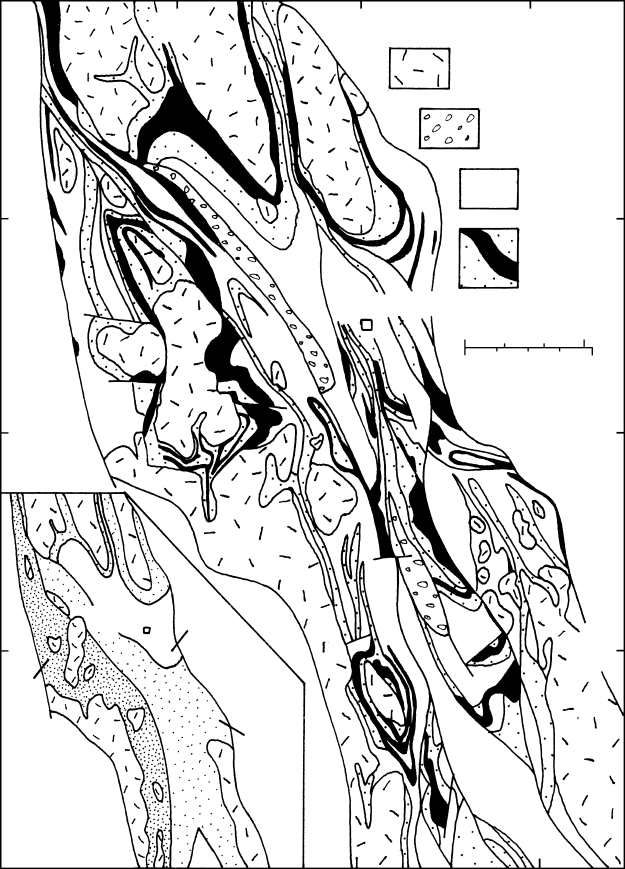
19.7 Archean (2750–2600 Ma) granite–greenstone terrane near Kalgoorlie in the eastern Yilgarn Craton, southern Western Australia. See
Figure 19.6 for location. Note complexly (polyphase) folded and faulted greenstone sequence between less metamorphosed granitoid
plutons. Smaller scale map of same area in lower left depicts character of metamorphic facies in the greenstone sequence. Redrawn from
Myers and Swagers (1997).
Precambrian Rock Associations
619
Kapuskasing uplift
Metasedimentary rocks (accretionary prism)
Granitic plutons (continental arc)
TTG plutons (island arc)
Greenstone belts (island arc)
55°N
50°
100°W90° 80°
0 500km
0 300miles
50°
55°
60°N
80°90°W
P
P
Hudson
Bay
2725 Ma
Wabigoon
Ph
2695 Ma
2705 Ma
P
Minnesota
River Valley
gneiss
complex
Lake
Superior
Wawa
Lake
Huron
P
Lake Michigan
Abitibi
Uchi
Sachigo
Ph
Ph
Ph
James
Bay
P
P
SOUTH
2725 Ma MRV
2629 Ma
MRV WA W US
2725 Ma MRV
WA W U S
WA W U S
Minnesota
River Valley
Wabigoon Uchi-
Sachigo
NORTH
Wawa Abitibi
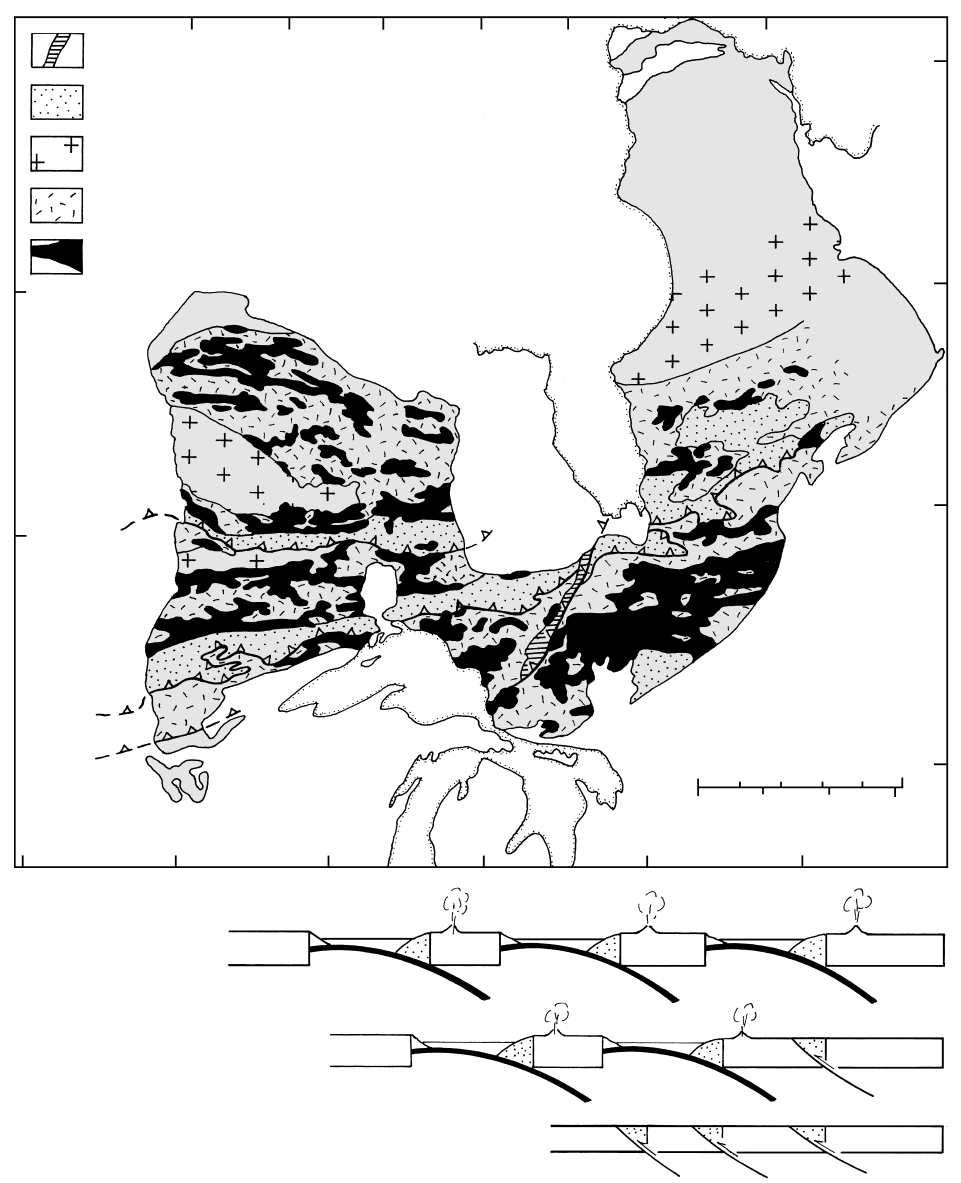
19.8 Archean Superior Province (shaded) of the south central Canadian shield. Redrawn from Hoffman (1989). P, Proterozoic rocks;
Ph, Phanerozoic rocks. Greenstone belts include Uchi-Sachigo, Wabigoon, Wawa, and Abitibi. Lines ornamented with open tri-
angles are major ductile shear zones or thrusts where terranes were sutured together at indicated times (2725, 2705, and 2695 Ma);
triangles are on upper, hanging-wall plate. Lower right is a series of highly schematic N–S cross-sections across western part of province
showing progressive southward closure of ocean basins and suturing of inferred Archean island arcs and continental segments along shear
zones. Shear zone striking southerly from James Bay bounds the upthrusted Kapuskasing section of the Wawa-Abitibi greenstone
sequence.
Complex had experienced granulite facies metamor-
phism at pressures near 10 kbar, indicating the exist-
ence of a crust at least 25 km thick (Nutman et al.,
1996). Also by that time, a variety of granitoids had
been intruded, including 3650 Ma granites geochemic-
ally resembling those in Phanerozoic collision and arc
settings and 3625 Ma granites and ferrodiorites resem-
bling those in anorogenic settings (Section 13.9).
Adding to this lithologic diversity was sediment de-
rived from the granitoids. Swarms of mafic dikes, in
part noritic, were intruded beginning about 3500 Ma.
These Ameralik dikes (Figure 14.38) may have accom-
panied rifting of the continental block composed of the
gneiss complex. Parts of it were metamorphosed again
at 3470 and 3140 Ma, the last events recorded in the
rocks.
It is important to put these Precambrian events in a
chronologic perspective. The geologic history recorded
in the Itsaq Gneiss Complex from 3900 to 3140 Ma is
about 200 Ma longer than the entire Phanerozoic
(about 570 Ma)!
19.2.3 Kaapvaal Craton
This and the neighboring Zimbabwe Craton to the north
are important Archean crustal segments in southern
Africa (Figure 19.3). The enormous mineral deposits
of the Kaapvaal have been responsible for extensive
geological investigations.
The oldest rocks are 3540 Ma TTG preserved as
remnants in the oldest greenstone sequences but
metasedimentary rocks contain detrital zircons as old
as 3700 Ma, implying the existence of still older felsic
620 Igneous and Metamorphic Petrology
Unmetamorphosed to weakly
metamorphosed intrusions
Greenschist and lower
amphibolite facies
Amphibolite facies
Upper amphibolite and granulite
facies, locally retrograded
Hudson
Bay
James
Bay
Lake
Superior
La
k
e
M
ic
h
i
g
a
n
Lake
Huron
55°N
50°
100°W 80°W90°
0
0
500
300
km
miles
50°
55°
60°N
80°W
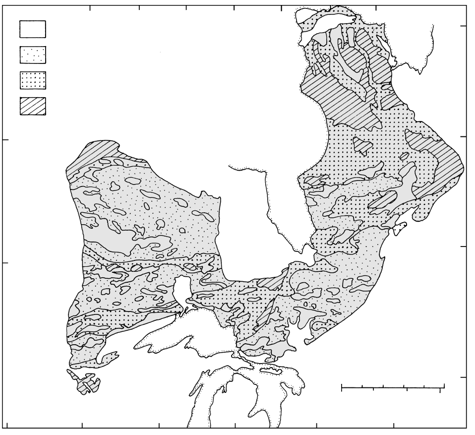
19.9 Metamorphic facies in the Archean Superior Province (shaded) of the south central Canadian shield. Compare with Figure 19.8.
Redrawn from Card (1990).
rocks (Kröner et al., 1996). In the Barberton fold and
thrust greenstone belt (Figure 19.4), the stratigraphic
sequence begins at the base with mostly komatiitic
and tholeiitic basaltic rocks overlain by lesser felsic
volcaniclastic rocks and chert and clastic sedimentary
rocks (Figure 19.5). TTG magmas locally intruded this
sequence. This predominantly oceanic sequence is
interpreted to have formed in relatively shallow water
where it was extensively hydrated and metasomatized
by advecting seawater (de Wit et al., 1992). Boundaries
between adjacent lithotectonic terranes that have dis-
tinctive rock units and deformational histories and
styles are all tectonic and display thrust, strike-slip, and
oblique movement. This tectonic overprint is believed
to have resulted from imbricate stacking of slices of
hydrated, hot oceanic crust, perhaps plateaus, that were
too buoyant to subduct. This convergent tectonism is
envisaged to have been not unlike that in the western
Pacific and Caribbean during the Mesozoic and Ceno-
zoic (Section 13.3.1 and Figure 13.17), except that a
thick buttressing continental margin was nowhere
present. Thickening of these stacks of mafic oceanic
rocks, including possible local island arcs (Figure
19.10), permitted dehydration partial melting in deeper
parts of the stack, generating TTG magmas (Figure
11.23). Intrusion of these granitoid magmas into the
overlying greenstone sequence was instrumental in
creating continental nuclei that had coalesced by about
3100 Ma into the proto-Kaapvaal Craton. Himalayan-
type collision of this cratonic assemblage with the Zim-
babwe Craton along the Limpopo Orogen, or “mobile
belt,” at 2680 Ma, resulted in significant crustal thick-
ening and final craton stabilization at about 2600 Ma.
Mantle-derived xenoliths in numerous kimberlite
and orangeite pipes (Figure 13.42) provide tantalizing
additional insights into the evolution of the Kaapvaal
Craton (Carlson et al., 2000). The oxygen isotope
composition of many Archean eclogite xenoliths is con-
sistent with derivation from basalt that was oxidized
under seafloor conditions before subduction into the
mantle. Archean harzburgitic and dunitic xenoliths
derived from depths of 200–250 km in the abnormally
cool, 350-km-thick lithospheric root beneath the cra-
ton are highly depleted in major compatible elements
(Ca, Al, Fe) and indicate extraction of appreciable
melt, possibly of komatiitic composition. The low Fe
and low modal garnet (resulting from low Al) makes
this residual mantle less dense than fertile mantle under
the same P–T conditions so that it more buoyant,
adding to the long-term stability of the craton. Re–Os
isotopes in the xenoliths indicate the growth of the
lithospheric root coincided with the main period of
crustal growth and thickening. A mantle plume is pos-
tulated to have played an important role in providing
mafic and ultramafic magmas.
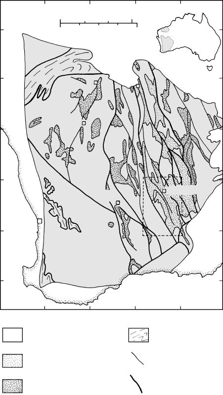
19.2.4 Yilgarn Craton
Archean TTG–greenstone cratons in Western Australia
(Figure 19.6) include the 3600–2800 Ma Pilbara in the
north and the younger Yilgarn in the south. Although
the Pilbara is well exposed (Figure 9.14) and has a
relatively complete rock record it is not as well docu-
mented as the Yilgarn (Myers and Swagers, 1997).
The Yilgarn Craton consists mostly of 3000–2600 Ma
granitoid plutons and greenstone sequences meta-
morphosed at low- to intermediate-grade; local high-
grade terranes occur along the western margin (Figure
19.6). In the northwestern Narryer terrane, the oldest
rocks are heterogeneous gneisses derived from 3680–
3600 Ma granite and 3730 Ma tonalite and layered
anorthosite, gabbro, and ultramafic rocks. After defor-
mation and metamorphism, more granite magma was
intruded at 3400–3300 Ma followed by migmatization
at 3300 Ma. Sedimentary rocks—quartzite, shale, and
banded iron formation—were deposited on the older
rocks between 3100 and 2700; some of these contain
detrital zircons as old as 4270 Ma—the oldest known
fragments of terrestrial rocks. Between 2780 and 2630 Ma
still more granite magma was intruded, all rocks
were subjected to granulite facies metamorphism and
intense deformation accompanied stacking of thrust
sheets.
Precambrian Rock Associations
621
Submarine
basaltic volcanism
Depleted
mantle
TTG
magma
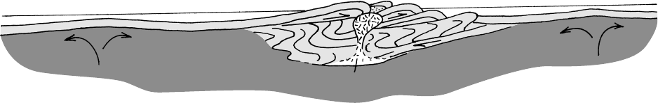
Intra-oceanic obduction
“flake” tectonics
19.10 “Flake” tectonics and granite–greenstone belts. Cartoon speculating that mafic–ultramafic oceanic crust produced by submarine
magmatism above a mantle plume or at a spreading ridge becomes hydrated and buoyant, moves laterally, and overthrusts onto a
thickening stack of oceanic rock, forming a volcanic greenstone sequence. The stack becomes thick enough so that dehydration melting
occurs at the base, generating TTG partial melts that diapirically intrude the overlying pile. Compare de Wit et al. (1992), Hoffman and
Ranelli (1988), and Davies (1992).

The stratigraphic sequence in the greenstone belt
around Kalgoorlie (Figure 19.7) resembles that in the
Barberton belt. Intense deformation manifest in tight
polyphase folding in this belt is particularly noteworthy.
Rock sequences and structures with histories that
range from 3730 to 2550 Ma (twice the duration of the
Phanerozoic) are superficially similar over much of the
Yilgarn Craton. Remarkably, some komatiitic–basaltic
sequences extend along strike for hundreds of kilo-
meters despite individual layers being 50 m thick.
Detailed work has revealed numerous distinct litho-
stratigraphic terranes separated by major fault zones.
Some zones are shallow dipping and extend to depths
of 25–35 km (based on seismic reflection data) and are
interpreted to be crustal-scale sutures. Regardless of
age, all terranes experienced intense tectonic, volcanic,
plutonic, and metamorphic activity between 2780 and
2630 Ma that created the present craton. This activity
amalgamated many continental nuclei, including what
are interpreted to have been—in a plate tectonic
view—volcanic arcs and back-arc basins.
Careful field work at two exceptional exposures
by Fripp and Jones (1997) has revealed a previously
unrecognized 2700 Ma ophiolite that they believe was
created in an oceanic spreading environment. In an
upper crustal section, marine sedimentary rock is under-
lain by Mg-rich mafic–ultramafic rocks consisting of
devitrified hyaloclastic breccia, pillow lavas, sheeted
amygdaloidal dikes and possible sills. All experienced
moderate-T alteration that created widespread actinolite
–tremolite and minor chlorite, serpentine; silica and
sulfides were introduced. In an apparent lower oceanic
crust–mantle transition, sheeted dikes with moderate-T
alteration are underlain by isotropic and local mylo-
nitic gabbro underlain by peridotite that has been
subjected to high-T metamorphism.
19.2.5 Superior Province
Almost one-fourth of the exposed Archean crust in the
world lies in the Superior Province of Canada (Fig-
ure 19.8). It shares significant similarities in the char-
acter of rocks and in evolution to that of the Yilgarn,
Kaapvaal, and other Archean cratons in consisting of
numerous terranes of differing histories and ages
(3300–2550 Ma) sutured together along crustal-scale
fault zones (Hoffman, 1989; Card, 1990; Stott, 1997).
In the Superior Province, greenstone belts resemble
modern island arc associations, terranes of metasedi-
mentary rocks resemble those in near-trench accre-
tionary prisms, and granitoid batholiths resemble those
in Mesozoic continental margin arcs. Protoliths in
accretionary prisms were mostly clastic sedimentary
rocks deposited in submarine fans with sources from
nearby volcanic islands. Interior parts of these
metasedimentary terranes were metamorphosed to
higher grade than margins. Continental arc granitoids
consist of early TTG and younger, less deformed, more
potassic granites; S-type granites are common. In addi-
tion, local high-grade gneiss terranes are thought to
represent more deeply eroded equivalents of the three
arc-related terranes. The oldest of these high-grade
terranes consist of granulite-facies orthogneisses and
amphibolites exposed in the Minnesota River Valley in
the southwestern part of the province. The gneisses
were plutons of tonalite and granodiorite intruded at
3660 Ma into older rocks and repeatedly metamor-
phosed and deformed at 3600, 3000–2800, and about
2700 Ma.
Abitibi Granitoid–Greenstone Belt: An Archean Island
Arc Association. The Abitibi terrane in the south-
eastern part of the Superior Province (Figure 19.8) is
not only the largest contiguous area of supracrustal
Archean rocks in the world but also one of the richest
mining areas; production during the twentieth century
exceeded 10
8
ounces of Au plus major amounts of Cu,
Zn, Ag, and Fe. Obviously, this well exposed terrane
has received considerable study.
Dominantly volcanic supracrustal sequences de-
posited from about 2750 to 2700 Ma consist of tholeiitic
basalts and lesser interlayered komatiites, which dis-
appear upwards, overlain by diverse tholeiitic and calc–
alkaline mafic–intermediate–felsic rocks, and capped
by marine sedimentary rocks. Local, late shoshonitic
and alkalic rocks unconformably overlie the calc–
alkaline sequence. The volcanic rocks were deposited
in two main environments (Dimroth et al., 1985):
1. Submarine lava plains made of basalt and lesser
komatiite lava flows erupted from fissures onto
nearly flat seafloor. Proximal to vents the flows are
massive but distally become more pillowed. Pillow-
and flow-breccias and hyaloclastic deposits are
common near flow tops and toes. Vesicularity in-
creases upwards, suggesting shallow water condi-
tions. Some large volume basaltic flows (100 km
3
)
covering hundreds of km
2
are believed to have
been extruded at high discharge rates; thicknesses
of hundreds of meters allowed development of dia-
basic and gabbroic interiors. Thin beds of marine
chert and shale were deposited among the flows.
Flow sequences, whose aggregate thicknesses is
5–10 km, resemble modern oceanic plateaus.
2. Mostly younger central volcanic complexes 15–30
km in diameter made of compositionally diverse
rock types and emplaced as pyroclastic deposits,
voluminous volcanic debris flows, and comagmatic
intrusions. Most central edifices began subaque-
ously but some grew into emergent volcanic islands.
Plutonic rocks include local layered gabbro–
anorthosite complexes intruding the lower tholeiitic
sequence, but more widespread are more or less
622 Igneous and Metamorphic Petrology
synvolcanic, and some comagmatic, TTG plutons and
younger (2700–2670 Ma) granodiorite, granite, and
syenite intruding the volcanic pile. Elongate domal
structures in the greenstone belts are cored by large
plutons and separated by synforms of thick volcanic
sequences. Younger plutons have higher-grade contact
aureoles than the generally prehnite–pumpellyite and
greenschist facies characterizing the regional green-
stone sequences (Figure 19.9). Metamorphism began
with seafloor alteration and was followed by meta-
somatism related to creation of massive volcanogenic
Cu–Zn sulfide concentrations and then by burial meta-
morphism; a culminating regional metamorphic event
included ductile deformation at about 2700 Ma.
Separating the Abitibi terrane and the similar
Wawa terrane to the west is the Kapuskasing uplift
(Figure 19.8). This linear terrane is the deeply eroded
hanging wall of a southeast directed overthrust of late
Proterozoic age that exposes a thick crustal section of
Wawa–Abitibi rocks (Figure 19.11).
Amalgamation of the Superior Craton was accom-
plished by convergence and suturing of arclike terranes
progressively from north to south along major, north-
dipping crustal-scale thrusts that are marked by ductile
shear zones from 2725 to 2695 Ma (Figure 19.8). A
component of lateral displacement along the shears
indicates oblique convergence of lithospheric plates.
The long-term geologic stability of the craton is related
to its unusually thick lithospheric keel (400 km based
on seismic data). Multiple swarms of Proterozoic basaltic
dikes (Figure 19.12) manifest repeated generation of
copious volumes of mafic magma. The depleted mantle
source in the lithosphere adds to the buoyancy of the
stable craton.
19.3 ARCHEAN VOLCANIC ROCKS
19.3.1 Komatiite
Although ultramafic cumulates of pyroxene and olivine
crystals in basal sequences of large differentiated
basaltic intrusions (Section 12.4.2) have been recog-
nized for many decades, the absence of ultramafic vol-
canic (aphanitic or glassy) rocks in the geologic record
had convinced petrologists that corresponding magmas
were nonexistent. However, this dogma was overturned
when Viljoen and Viljoen (1969) described exactly
such rocks near the Komati River in the Barberton
Greenstone Belt in southern Africa (Figure 19.4). Soon
after, similar ultramafic lava flows were described in the
Yilgarn block of Western Australia (Nesbitt, 1971) and
in the Superior Province of Canada (Pyke et al., 1973).
Precambrian Rock Associations
623
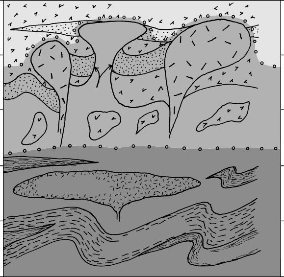
Depth (km)
0
10
20
30
40
50
TTG
TTG
Amphibolite
faciesGranulite facies
Greenschist
facies
Meta-
sedimentary
rocks
Metavolcanic rocks
Granite
Paragneiss
Mafic gneiss
Tonalitic gneiss
Anorthosite
19.11 Schematic crustal section through the Abitibi Granite–Greenstone Belt as exposed in the Kapuskasing uplift. Redrawn from Hofmann
(1989; original source is J. A. Percival in an unavailable NATO workshop publication). See Figure 19.8 for location of Kapuskasing
uplift.
Komatiites have now been found on every continent
except Antarctica (see summaries in Arndt and Nisbet,
1982; Arndt, 1994; Arndt et al., 1997). Because ko-
matiite constitutes 5% of the total volcanic rocks in
most greenstone belts and in many belts is absent, it is
not surprising that recognition took so long, especially
because of the universal metamorphism of greenstone
belts.
Although most komatiites are Archean, many are
Proterozoic. The youngest, and apparently only
Phanerozoic, occurrence is on Gorgona Island, Colom-
bia (Section 13.3.1) that is part of a late Jurassic–
Cretaceous accreted oceanic plateau. Because so little
is known of nonaccreted plateaus in their oceanic en-
vironment, it is uncertain whether there may be other
Phanerozoic komatiites. The reason for the decrease in
komatiite occurrences since the Archean is debat-
able but the prevailing opinion is that conditions for
generation of ultramafic magmas were more favorable
in the hotter Archean mantle.
Petrography. Komatiites have a simple primary min-
eral composition of olivine and clinopyroxene plus
accessory chromite or Cr-rich magnetite. Even the
freshest rocks are metamorphosed to some degree so
that original widespread glass is invariably devitrified
and magnesian olivines (near Fo
90
) are always replaced
to some degree by talc, serpentine, and minor mag-
netite. Magnesian, Al-rich clinopyroxenes are variably
altered to chlorite, tremolite, and epidote.
In contrast to their simple primary mineralogy, the
fabric of komatiites is complex. Subaqueous lava flows
that are generally only a few meters thick are pillowed,
flow tops are brecciated and glassy and have relict vesi-
cles. Locally, komatiite occurs as volcaniclastic deposits
and as intrusive sheets (sills) that may be locally
624 Igneous and Metamorphic Petrology
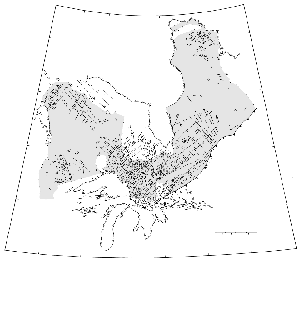
90°W
60°N
80°
Hudson
Bay
70°
55°
50°
45°
90°W
80°
70°
45°N
50°
60°
55°
Matachewan
2470
Mackenzie
1267
Molson
1884
Lake
Winni-
peg
Hearst
2450
L
a
k
e
S
u
p
e
r
i
o
r
Keeweenawan 1100
Lake
Huron
Sudbury 1238, 575
Lake Michigan
Abitibi 1141
Grenville
Front
Preissic
0 400km
0 250miles
19.12 Basalt dike swarms in the Superior Province, Canada (shaded). Age of swarm in Ma. Redrawn from Card (1990).
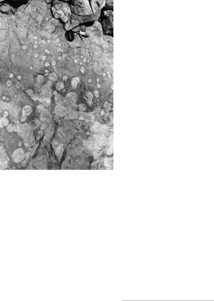
19.13 Relict ocelli in Archean tholeiitic basalt metamorphosed under
greenschist facies conditions. This locally pillowed basalt is in
the Komati Formation in the Barberton Greenstone Belt,
South Africa (Figures 19.4 and 19.5). Pale gray centers of
ocelli are mostly plagioclase, whereas thin darker rims are
mostly amphibole and chlorite. Camera lens-cap for scale.
Photograph courtesy of Maarten de Wit.
pillowed. Komatiites and kindred basalts are generally
aphyric and many have spherulitic aggregates called
varioles or ocelli (Figure 19.13; see also de Wit and
Ashwal, 1997, p. xvii). These radial bundles of inter-
grown needles of clinopyroxene (replaced by secondary
amphiboles) and plagioclase are commonly coalesced
balls that range from 0.5 to 50 cm in diameter. Whether
they formed as immiscible melt segregations or by
some other means is controversial but the aphyric
nature of their host rock and common occurrence with
devitrified glass suggests an origin by rapid cooling
of superliquidus melts (compare similar spherulites of
felsic minerals in Figure 6.15d).
Widespread and locally thick volcaniclastic deposits
of komatiite have been found in the Barberton green-
stone belt (Lowe and Byerly, 1999). All have been ex-
tensively metasomatized, mostly to chert (about 90%
SiO
2
), and were previously interpreted to have felsic
protoliths; however, the absence of relict felsic minerals,
Precambrian Rock Associations
625
their repeated occurrence at the tops of layers in a
komatiite sequence, and their immobile trace element
concentrations, ratios, and patterns indicate a koma-
tiite ancestry. These deposits are believed to have res-
ulted from hydromagmatic eruptions in water depths
of 700 m.
The most distinctive fabric of komatiite is spinifex
texture, named after a spiky Australian grass. “Spinifex
is a texture characterized by large, skeletal, platy,
bladed or acicular (needle-like) grains of olivine or pyro-
xene, found in the upper parts of komatiitic flows, or,
less commonly, at the margins of sills and dikes. The
texture is believed to form during relatively rapid,
in situ crystallization of ultramafic or highly mafic
liquids” (Arndt, 1994). Spinifex consists of arrays of
criss-crossing sheafs of subparallel blade-like olivines
that can be as long as 80 cm but 1 cm thick or of
clinopyroxenes (Figure 19.14b). Between such crystals,
and comprising about half of the spinifex zone of the
flow, is a finer-grained aggregate of devitrified glass,
skeletal to feathery clinopyroxenes, and skeletal
chromites (Figure 19.14c). Olivine crystals are largest
at the base of the spinifex zone and are oriented sub-
perpendicular to flow margins; they grew normal to the
cooling surface in the direction of maximum supersat-
uration (compare comb layering, Figure 7.47).
Not all the details of spinifex texture have been ac-
counted for, but a basic picture has emerged. Komati-
ite magmas have very low viscosities (0.1–1 Pa s; Figure
6.2). Because of the scarcity of phenocrysts, magmas
appear to have been near liquidus temperatures or
even superheated when extruded. If so, homogeneous
nucleation of crystals could have been inhibited (Sec-
tion 6.5.2). As the unusually hot melt loses heat upon
extrusion or very shallow intrusion in subaqueous
environments, heterogeneous nucleation on quenched
margins of the melt may have dominated. In the low
viscosity, non-polymerized melt structure, rapid diffu-
sion permitted rapid growth of platy, skeletal olivines,
clinopyroxenes, and chromites.
The origin of layering (Figure 19.14a) in horizontal
sheets of komatiite, whether lava flow or sill, has been
controversial. The original proposal of Pyke et al.
(1973) was that any olivine phenocrysts present in the
sheet as it was emplaced, or that grew immediately
thereafter, gravitated to the base in the very low vis-
cosity melt, creating an olivine-rich cumulate; concur-
rently, spinifex crystals grew downward from the top.
Chemical Composition and Origin of Magmas. Chemic-
ally, komatiites are defined as having very low alkalies,
MgO 18 wt.%, TiO
2
1 wt.%, and SiO
2
53 wt.%
(Le Maitre, 1989). Chemical variations resulting from
olivine fractionation within a particular body far exceed
the effects of variable partial melting conditions in pos-
sibly variable mantle sources, of crustal contamination,
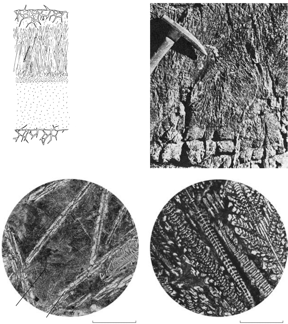
(b)(a)
Overlying flow
Brecciated flow top with
filling of tremolite
chlorite serpentine
Spinifex zone
Aligned skeletal olivines
Medium- to fine-grained
komatiite with downward
enrichment in gravity-settled
olivines; also contains
skeletal clinopyroxenes
and relict glass
Underlying flow
(c) (d)
Feathery
clinopyroxene
Olivine
0 0.5mm 0 0.15mm
19.14 Fabric of komatiite lava flows. (a) Idealized cross-section through a layered lava flow. Redrawn from Pyke et al. (1973). (b) Coarse
spinifex texture enhanced by weathering of Archean lava flow in the Superior Province, Canada. Photograph courtesy of N. T. Arndt.
(c) Microspinifex texture under plane polarized light. Devitrified glass and feathery clinopyroxenes between platy skeletal olivines that
are 1–2 mm long. (d) Plane polarized light photomicrograph showing skeletal clinopyroxenes that are embedded in devitrified glass
(black) and lie between platy olivines (not shown). (c) and (d) are of the late Mesozoic Gorgona Island, Colombia, komatiite (Section
13.3.1). Photographs courtesy of Lina M. Echeverria.
of alteration, or of any other perturbing process.
Plots of compatible and incompatible elements define
olivine-control lines that are useful in determining
what elements were mobile during metamorphism of a
626 Igneous and Metamorphic Petrology
particular komatiite. MgO is commonly plotted on two-
element variation diagrams because of its substantial
range, as much as 16–50 wt.% in extremely fraction-
ated sheets. Compatible Ni and Mg co-vary whereas