Wai-Fah Chen.The Civil Engineering Handbook
Подождите немного. Документ загружается.

Geographic Information Systems
57
-9
of real-world elements. Through the use of composite features, a logical spatial feature may be defined —
such as a school district composed of a school district boundary, a set of school facilities (classrooms,
playing fields, administrative offices), school bus routes, and residential catchment areas — that permits
more sophisticated modeling of spatial elements.
More sophisticated topologic structures involve those that allow the formation of a single seamless
geographic base structure, where graphic or geometric components cross tile or district boundaries that
are stored in distinct files or database tables, but referenced. In such systems users may access large or
small spatial features.
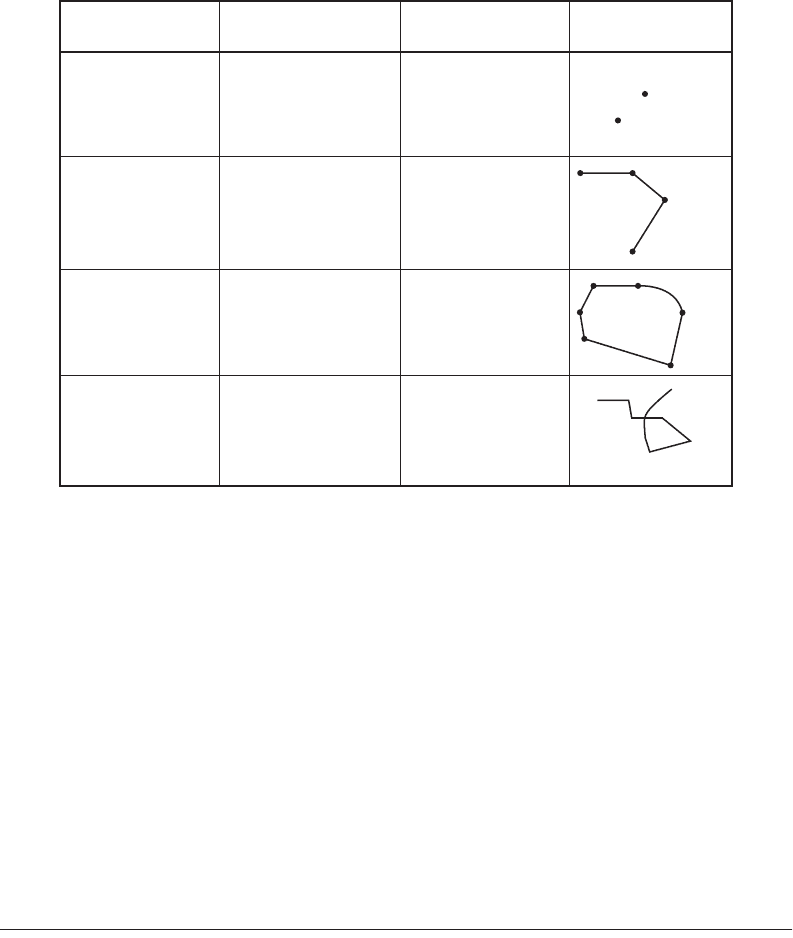
Topologic structures such as those identified in Fig. 57.7 form one of the most critical aspects of a GIS
since they determine how efficiently certain operations or analyses can be performed. (Network analysis
depends on connectivity between line elements; polygon analysis requires handling of closed polylines,
islands, and so on.)
57.3 Modeling Geographic Information
In this section various methods of modeling spatial information are described. The method chosen has
broad implications on the scope and application of GIS.
Layer-Based Approaches
The traditional method of classifying information in a geographic information system derived from the
ability to graphically distinguish various layers or levels of data, also affected by the practical limitations
of available computing capacity (for example, limits of 256 layers or 32 colors in a palette). Compared
to previous means of producing hard copy maps, though, these restrictions did not prevent reasonable
modeling of geographic data. Rather, it allowed the storage, maintenance, and manipulation of many
more levels of information than previously possible through manual drafting or overlay means.
FIGURE 57.7
Node-line-polygon topology.
Topologic Type
Node / point discrete x,y(,z)
identifying unique
feature
position / proximity
B
A
A
A-B
straight-line (two
points),
arcs / circles,
splines
series of connected
line segments
sequence of connected
points, with no
topologic checking
continuity /
connectivity
nodes at all
intersections and at
endpoints
areal closure /
adjacency
length (line segments
may cross/intersect
each other)
Line
Polygon / surface
Spaghetti
Description Properties /
Operations
Graphical
Representation
© 2003 by CRC Press LLC
57
-10
The Civil Engineering Handbook, Second Edition
In a layer-based approach, the ability to distinguish different types of information relies on a common
definition and usage of layers, the schema or data dictionary. Such a schema, agreed upon by all potential
users, defines that graphic primitives (lines, arcs, point symbols, text labels) common to a well-defined
set of spatial features are stored in separate and distinct layers. The layer specifications determine how
information once collected can be used, since in a graphics system the layer may be the only level at
which logical data may be segregated. For example, text labels annotating parcel numbers may be stored
in layer 25, and parcel boundaries themselves (the graphical primitives) in layer 24: By separating text
and pure graphics, it is then possible to display either graphics, text, or both. In practice, separate layers
of information may in fact reside in separate files on disk, physically as well as logically distinct. The
layer-based model is closely analogous to logical map overlays or use of color separates as used in map
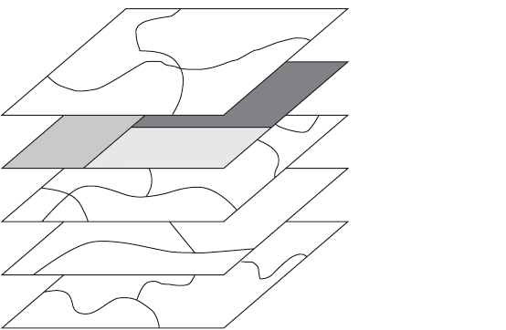
production. Figure 57.8 shows typical graphical layers in a GIS.
Relational Approaches
As a first step in the evolution from a purely graphical system, it was recognized that links to additional
nongraphic attributes in a GIS would radically increase the utility and power of such an information
system. Although early GISs provided an ability to graphically model and depict cartographic information
(much in the same way that paper maps had done previously), such systems became extremely cumber-
some and limiting when trying to really apply the power of computers to selective retrieval and analysis
of spatial information. This resulted in the development and introduction during the 1980s of a GIS
with two distinct components: the graphical database or file system, and an associated nongraphic
database system. Early systems used proprietary database structures to store and reference nongraphic
information, but the more rapid growth and acceptance of GIS in the past few years has come with the
use of standard commercial relational database management systems (RDBMS). Spatial information
systems using such an approach are also referred to as
geo-relational
or
all-relational
GIS, the latter term
denoting that at least some of the geographic or graphic components are also stored in a relational model.
The simplest relational model used in GIS consists of a graphics-based component that carries with
each geometric primitive (point, line, or polygon) a unique internal identifier or tag, which is the means
to associate the geometry with additional nongraphic information defining the characteristics of the
spatial feature. The geometry identifier is therefore the common key upon which the power of the
relational GIS depends. Although the use of such identifiers is often hidden from the casual user, its role
is critical: the means that a GIS software system uses to establish and maintain this vital link between
graphics and nongraphics determines the practical potential of the system.
FIGURE 57.8
Layers in a geographic information system. (
Source:
ESRI. 1992.
ARC/INFO: GIS Today and Tomorrow
.
ESRI, Redlands, CA.)
Soils
Land Use
Geology
Floodplain
Etc.
- Utility lines
- Planimetric features
- Graphic symbology
© 2003 by CRC Press LLC
Geographic Information Systems
57
-11
Once linked using the relational model, commonly used and widely understood techniques and tools
may be applied in all areas of spatial data management, including data collection, update of nongraphic
information, extraction, and reporting. Apart from the key link between geometry (graphics) and primary
attribute (nongraphics) tables, it becomes a simple matter to extend the model through additional tables
and keys. Common elements in such tables may be used as additional keys through table joins to incor-
porate the spatial context to a variety of nongraphic information. For example, property information
including property addresses can be joined with a table containing address and telephone number in order
to provide direct retrieval of phone numbers based on property and location. The relational model can
also be used to associate sets of geographic features with common characteristics, such as those properties
lying in a specific school district, thereby extending the spatial and logical models as appropriate.
In addition, certain relational terminology can be applied directly in the spatial domain: for example,
a polygon overlay can be viewed simply as a “spatial join.”
With the acceptance of standards within the RDBMS industry and with extensions of commercial
products to provide transparent access and manipulation of information in a broadly distributed network
of computing platforms, the geo-relational model has fit well for those GIS projects seeking to play a key
role in a multidepartmental or enterprise-wide information technology environment. In such situations
the GIS project manager is often happy to take advantage of these standard commercial products and in
turn is able to concentrate on issues of data management specific to the geographic nature of the
information.
As already mentioned, it is also possible to model geometry and topology using relational database
technology. In such GIS, sometimes referred to as all-relational, such information as start and end nodes,
pointers between line entities, and polygon elements may be stored in the form of relational tables. A
purely relational approach sometimes adds tremendous computing overhead for simple operations in a
GIS (for example, geometric editing of polygonal areas) and may require additional levels of information
to be stored in a hybrid fashion to improve performance. Figure 57.9 shows the geo-relational model.
Object-Oriented Approaches
Object-oriented approaches in data modeling were applied early on in CAD products, in such areas as
construction and manufacturing. Such a model allowed an architect to apply object-oriented rules to
form walls with certain properties and optional or mandatory components (for example, windows and
doors). Once a certain type of (standard) window had been modeled, it could be introduced and reused
wherever appropriate.
FIGURE 57.9
The geo-relational model. (
Source:
ESRI. 1992.
ARC/INFO: GIS Today and Tomorrow.
ESRI, Redlands,
CA.)
1
2
8
9
12
13
14
11
#
1
2
3
4
5
6
7
Soils
Current
Land Use
Geology
Floodplain
Topologically Structured
Cartographic Data Display
and Manipulation
Tab ular Data Integration
and Manipulation
(using a Relational Database
Management System)
10
4
3
5
6
7
Feature
ID
© 2003 by CRC Press LLC
57
-12
The Civil Engineering Handbook, Second Edition
Over the past few years, object-oriented techniques have been applied to GISs in at least two major
areas: (1) spatial data modeling, and (2) spatial analysis or programming tools.
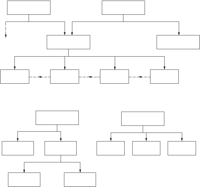
In any geographic information system the database and related software attempt to create an abstract
model of the real world (as in Fig. 57.10) containing spatially dispersed information. The closer this abstract
comes to modeling true characteristics of the physical and human-made world, the more powerful can be
the application of computing power to interpret and provide decision support based on the geographic
information. We discussed in a previous section the various components of spatial information: An object-
oriented approach to spatial data modeling allows all related components to be encapsulated in a single object
or feature definition, along with rules that govern how the object may be manipulated or how components
may be related or dependent on components of other objects. The terms
feature oriented
or
feature based
are
also used to denote software systems in which the modeled entity is intended to closely reflect the real-world
element or object. In such an example a land-ownership record may be treated as a single spatial object or
feature containing one or more boundary lines with surface (polygon) topology, additional nongraphic
characteristics, and logical associations. Relationships based on common boundaries (logical adjacency) or
common ownership may be accommodated. The object-oriented paradigm allows for the modeling of
sophisticated groupings of geographic and logically related elements, such as a “census tract” composed of a
collection of “parcel” objects, or a “gas distribution network” composed of various subelements such as
“pipes” and “valves.” Once such elements are defined, the data dictionary contains not just a list of element
classes, but the rule base for their use and application. This permits, at least in theory, the population of
highly structured geographic data sets in which many real-world relationships and constraints are retained.
Many GIS software products now claim to be object oriented or feature oriented. To a certain degree,
such GISs have introduced levels of object-oriented user interfaces or modeling techniques, which may
mask a layer-based or fully relational model that the system uses internally. For the time being at least,
FIGURE 57.10
A GIS data model.
Composite
Feature
Simple
Feature
node line surface raster
pipe line
community
parcel
Composite
Feature
Composite
Feature
metersvalvesgas pipescity block
buildingboundaries
© 2003 by CRC Press LLC
Geographic Information Systems
57
-13
there are few GIS products that claim to be fully object oriented in both data modeling and data storage:
This situation will probably change as object-oriented database management systems (OODBMS) become
more widespread.
Extended Relational Model
Although the object-oriented paradigm carries many advantages — especially in areas of accurately
modeling real-world phenomena or features and ability to develop or customize geo-related applications
based on reusable blocks of code — the relational model carries with it many positive aspects when
considering implementation of GIS projects. These relate to existing (or legacy) information systems that
are to be somehow incorporated into or integrated with geographic information, the flexibility and
increasing power of commercial RDBMS in handling large amounts of distributed data, and the use of
industry-standard products and techniques in accessing and manipulating such information. The use of
structured query language
(SQL) and products such as Oracle and Informix has become widespread in
large and small organizations, to the extent that large commercial companies may choose to standardize
on the use of a specific RDBMS product. Commercial database products are constantly being extended
to address such areas as multimedia (additional and custom data types), the object-component paradigm,
as well as specific requirements for spatial data. In this way the growth of OODBMS is being countered
by the major RDBMS vendors, many of whom are in the best position to package and offer the best of
familiar (relational) technology with additional features addressing these more specialized requirements.
The geographic information system places a considerable burden on data management, from the
aspects of both modeling real geographic features and the various types of spatially distributed data. A
GIS is often seen as providing the common interface or natural reference system to which attribute,
vector, raster, video, sound, and other multimedia data are to be attached. Such an information system
was beyond the scope of purely relational database management technology a few years ago, but now
several RDBMS provide the facilities to develop such support in an extended relational model.
Security and Information Sharing in a GIS
Early GIS projects were restricted to single users or single departments where data were gathered and
processed by at most a small group of individuals. In such implementations little attention was paid to
the role of making information secure or of handling multiple user transactions.
However, in many organizations today, the GIS project implementation carries a significant weight as a
means of integrating or linking multiple agencies and departments based on (spatial) elements of common
interest or value. The general problems of data duplication, inconsistencies, and inaccuracy associated with
uncontrolled access to all information within the database system can no longer be ignored. In fact, the
introduction of multiuser security to spatially related data elements allows the full benefit of a GIS.
First of all, the layers or classes of information stored in a GIS are typically of interest to more than
one user or group of users. However, one user or department is responsible for the creation and
maintenance of a single class of data. The goal must be to eliminate duplication both of spatial geometry
and of attribute information.
As an example, in a large municipal environment, the private land ownership unit — the “parcel” — may
have many fields associated with it. The same parcel is referenced by many departments, but each department
views the fields differently. Most importantly, only one department — for example, the department of
public works — is empowered with the creation of new property boundaries. This department must
work closely with the appraisal district to allow the assignment of a unique property identifier and street
address, to allow further information to be applied correctly. Figure 57.11 shows additional examples.
Data inconsistencies can be minimized by the use of controlled procedures and standards for all
information handling. However, a database system must also provide controls by allowing tables and
basic elements to be accessed in a read-only mode, for read-write, or to be completely restricted. When
dealing with geographic data, the example above shows that although one user may require write access
to geometric components of a spatial object, other users require write access to specific attribute fields
© 2003 by CRC Press LLC

57
-14
The Civil Engineering Handbook, Second Edition
for which they are responsible. For example, the assessor is responsible for assigning taxable values to
individual properties, whereas the planner may be responsible for the zoning for specific properties. A
good GIS provides a unified database management system that permits such combinations for geometric
and attribute components. In addition, many GISs that rely on the relational model support and make
use of security characteristics of the underlying relational database management system. In this situation
individual tables and table records may be locked for read-only access or restricted completely.
In many GISs access to spatial data is managed in conjunction with a checkout procedure, whereby a
group of information corresponding to the area of interest (a map sheet for example) is made available
to one user only for updating and restricted to read-only access for all others. A transaction-oriented
information system often takes this to a more elemental level, in which any database transaction locks
out a small set of data immediately prior to the transaction. An AM/FM system often aims for this level
of security, in which changes to facilities status and geometric elements are critical. This issue of con-
currency — where in theory no two users may access the same data elements for update at the same
time — can be achieved only with a sophisticated management of graphic and attribute elements.
57.4 Building and Maintaining a GIS
This section discusses the primary issues in building a geographic information system.
Reference Coordinate Systems
A geographic information system requires the definition and application of a reference coordinate system.
The choice of a reference system is typically based on accuracy requirements, geographic scope of the
FIGURE 57.11
Security in a multiuser GIS. This diagram shows read/write access privileges to classes of information
for three different groups of users (departments) in a multidepartmental GIS.
CLASS / LAYER
PARCEL
boundary write read read
identifier read write read
street address write read read
land value - write read
improvement value - write read
total value - write read
date of last sale - write read
owner name - write read
owner address - write read
zoning read read write
tax district read read write
centerline write read read
right-of-way write read read
name write read read
boundary - write read
name - write read
taxes - write read
STREET
TAX DISTRICT
attributes
Users
Public Works
/ Engineering
Assessor Planning
© 2003 by CRC Press LLC

Geographic Information Systems 57-15
proposed GIS, and the predominantly used reference system for source data, as shown by examples in
Fig. 57.12.
For example, engineering and property maps within a small municipality are typically referenced to
a local grid based on state plane coordinates. An information system that is to be applied for work at
national or international levels may require the use of a true geographic reference system (latitude,
longitude) to provide true seamlessness and consistency across the entire area of interest. It should be
noted that the reference coordinates for the GIS database storage often differ from a local working
coordinate system. For example, data entry may derive from large-scale maps referenced to state plane
coordinates. In this situation the digitizing and data validation operations take place in state plane, but,
once complete, all information is transformed and stored in the project’s primary coordinate system.
Information may later be extracted and presented in a variety of local coordinate systems, without
corrupting the primary data storage.
Consideration of Scale
In a traditional mapping system, consideration of precision of data is closely tied to final map scale. In
theory, a GIS requires a much broader view of both data accuracy and precision, because it is open to
data at large range of scales and accuracies. Unfortunately, most GISs do not in practice allow the
maintenance of data quality and accuracy information. Furthermore, many applications of GISs involve
the merging and integration of spatial data of differing resolutions and accuracy. The results of such
operations are often used in decision support without regard to their statistical reliability. For example,
the results of overlaying parcel boundary information derived from 1≤ to 50¢ scale property maps and
soil classification boundaries derived from 1≤ to 1000¢ orthophotos may be used to determine the taxable
value of farm properties.
It is therefore critical that the overall design of a GIS takes into account the accuracy requirements as
a function of the application intent.
Data Sources
A variety of data sources are available for input to a GIS, as depicted in Figs. 57.13 and 57.14. They can
be classified most simply as follows:
•Local maps and related documents
•Existing local information systems
•Commercially available information
•Government sources
GIS implementation is often the driving force behind conversion of existing maps and other documents
and records.
FIGURE 57.12 Reference systems for source data.
Type Extent Source Data
Latitute/Longitude
(geographic coordinates)
global field geodetic / world maps
Universal Transverse Mercator
(UTM)
worldwide zones, each 6
degrees of latitude wids
national / transcontinental
US State Plane Coordinate
System
State / portion of State state / country maps and
documents
Project-specific Projectwide (engineering /
construction)
airport / builting site
© 2003 by CRC Press LLC

57-16 The Civil Engineering Handbook, Second Edition
Data Entry and Processing
The data entry process may be reviewed in terms of:
•Interactive or semiautomated conversion of existing map documents
•Interactive update of attribute information through use of forms
•Batch loading of digital files
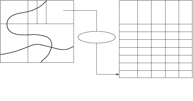
Interactive digitizing of existing maps has been superseded in part by a semiautomated process in
which documents are scanned, displayed as a registered backdrop to vector data, and converted as
necessary. Software that provides line-following and recognition capabilities, augmented by text recog-
nition and a rules-based means to associate printed text labels as descriptors for adjacent graphic elements,
may be applied successfully to conversion projects involving a large number of consistent map documents.
FIGURE 57.13 Ty pical data sources. This table indicates typical source materials and methods of spatial data collec-
tion, with resultant accuracies.
FIGURE 57.14 Data sources.
Source Source Accuracy
Scale
Field Survey, total station .02 m
Field Survey, GPS Carrier Phase Differential .05 m
Photogrammetry, large scale 1:4,000 0.3 m
Digitized Engineering Map 1:600 0.5 m
Photogrammetry, medium scale 1:16,000 1.5 m
Photogrammetry, small-scale 1:40,000 3 m
Field Survey, GPS Pseudo-range Differential 5 m
Digitized USGS Quad sheet 1:24,000 15 m
Bureau of the Census TIGER files 1:24,000 20 m
Remote Sensing, SPOT panchromatic, rigorous 20 m
model
Field Survey, GPS pseudo-range single receiver 50 m
Remote Sensing, Landsat TM panchromatic,
rigorous model 60 m
USGS Digital Line Graph 1:2 million 100 m
existing databases
vector data
scanned maps
alphanumeric data
documents &
photographs
field survey
coordinate
geometry
photogrammetry
on-line digitizing
forms mode
data entry
maintain
geometry & attributes
satellite images
GIS
© 2003 by CRC Press LLC
Geographic Information Systems 57-17
In addition, a key component to GIS database implementation is the linking of existing information
systems. This is achieved as part of the overall database schema definition by identifying the key that
provides the link between the core GIS and the existing data records. For example, the digitizing of parcel
maps may include the interactive input of parcel identifier. Once a spatial feature containing the parcel
number has been created, existing databases also containing the parcel number can be incorporated and
accessed through the GIS. Alternatively, the parcel number may be used as a key to load additional
attributes through a batch import process or as a guide to interactive form entry.
Structure/Topology
The data entry process normally includes facilities to check overall consistency and validity of data. The
level to which these facilities operate is determined by the source data and the means of entry.
For digitizing operations and import of digital files representing vector geometry, it is critical that the
input geometry defines a record that is consistent with both nongraphic descriptors and other graphic
elements. For processing of vector line data, operations that determine intersections with adjacent
geometry, extend lines to provide polygon closure, or eliminate overshoots are typically applied. Since
these operations alter geometric components, they must be used with care and often use a correction
tolerance determined by the ultimate accuracy requirements. This operation is often referred to as
“building and cleaning,” or “feature assembly.” In addition, the process of “conflation” allows the merging
of line data from disparate sources to minimize data storage and permit more consistent assignment of
descriptive attributes. For example, street centerlines derived from small-scale TIGER data may be
conflated to highway alignment data derived directly from the local engineering department. This process
actually “moves” inaccurate TIGER geometry to the more accurate engineering data, but then allows the
use of the other TIGER data, such as street names and address ranges. Figure 57.15 identifies database
and geometry linkages used to build a GIS.
FIGURE 57.15 Database and geometry links. (Source: ESRI. 1992. ARC/INFO: GIS Today and Tomorrow. ESRI, Red-
lands, CA.)
Polygons
Arc ID Left/Right Poly
Coordinate
Date
Arc ID
Coordinate
Date
Coordinate
Date
Point
ID
Point
ID
VAR
1
VAR
2
VAR
3
VAR
1
VAR
2
VAR
3
Arc
ID
VAR
1
VAR
2
VAR
3
Poly
ID
Lines
Points
© 2003 by CRC Press LLC

57-18 The Civil Engineering Handbook, Second Edition
Maintenance Operations
Once the primary spatial database has been created, it is important that maintenance operations may be
applied without corrupting either geometric or attribute components. This is the most critical aspect to
GIS editing as compared to a graphics-driven CAD system, in which the graphical elements and repre-
sentation are most critical. For this reason, maintenance operations are most often performed on a
primitive spatial object with both graphic and attribute components accessible. Nongraphic updates and
edits may take place at a graphics workstation or at a simple alphanumeric screen, where operators update
form entries.
57.5 Spatial Analysis
Beyond the implementation of GIS purely for mapping and map production, its key value lies in the
ability to perform analysis based on spatial location and relationships between spatial elements. Such
spatial analysis is augmented by the incorporation of external database records and application models.
Database Operations
We will now consider three groups of database operations associated with spatial information systems.
The first is simple querying and identification of individual geographic features and all related infor-
mation. These may be nongraphic queries that return information based on nongraphic characteristics
or graphical queries that incorporate a spatial extent to limit the extent of a querying process. Address
matching, in which a nongraphic query provides street locations and/or property identification, is a
fundamental operation in linking address as a reliable key between geographic and nongraphic informa-
tion. Conversely, a graphical selection (for example, by pointing to a display) can be used to return a set
of nongraphic information or a report. Querying and extraction operations are described later in this
chapter.
The second group of operations are based on pure spatial analysis, based on geometric properties of
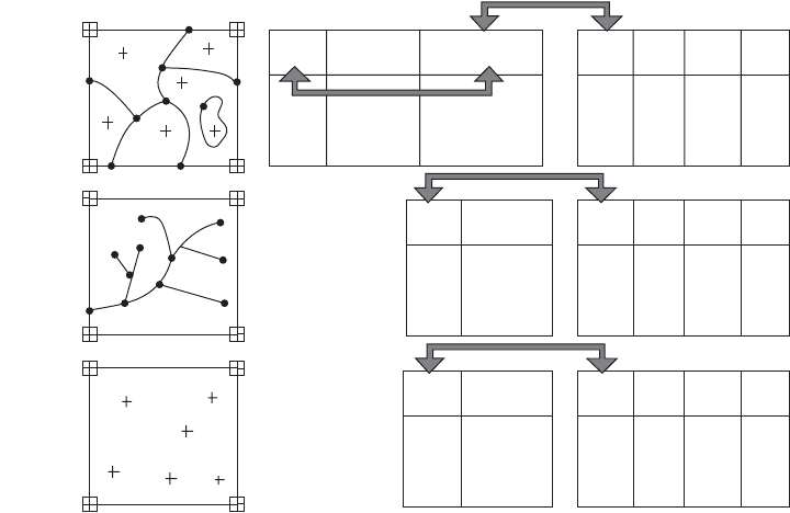
individual elements. These apply to point, line, and polygon data as seen in Fig. 57.16. These include the
generation of polygonal buffers around points, lines, or polygons and the overlay of multiple layers of
polygonal information to provide a “spatial join” to be used in further processing and analysis. Properties
such as proximity, distance, overlapping, and containment are included in this group.
The third group of operations rely on point, line, and polygon topology to provide the basis for analysis.
Such properties as adjacency, connectivity, and composed of are included in this group. Linear network
analysis provides the basis for shortest path calculations in transportation, distribution, and collection
applications. Figure 57.16 identifies some commonly used spatial database operations.
Of course, the typical GIS application may use many database operations, spatial and nonspatial, to
provide the desired answer. As an example, the simple question “How many people live within 1/2 mile
of the proposed light rail line?” is typically answered by proceeding through the following steps, each
one a distinct database operation:
•Identify the light rail line (spatial).
•Create a 1/2-mile corridor/buffer based on the location of the rail line.
•Overlay the rail corridor against census block information.
•Transfer demographic information from census blocks to results of overlay.
•Produce summary statistics for population from the overlay.
Coupling to External Analyses/Applications
As previously discussed, the geographic information provides a powerful, common context for many
different applications. In many cases the geographic key provides a much more significant means of
interpretation or analysis than a simple numeric or textual key (for example, location versus street
© 2003 by CRC Press LLC