Wai-Fah Chen.The Civil Engineering Handbook
Подождите немного. Документ загружается.

56-38 The Civil Engineering Handbook, Second Edition
Microwave Remote Sensing
Microwave radiation has the useful characteristic of penetrating clouds and other weather conditions which
are opaque to visible wavelengths. Aircraft-based imaging radars are thus able to acquire imagery under
less restrictive flight conditions than, for example, conventional photography. The geometry of the radar
image is fundamentally different from the near perspective geometry of other sensor systems. In both real
aperture side-looking airborne radar and synthetic aperture radar, imagery is presented as a succession of
scan lines perpendicular to the flight direction. The features displayed along the scan lines have positions
proportional to either the slant range or the ground range, and the image density or gray level is related
to the strength of the return. Radar imagery can be acquired of the same area from two flight trajectories,
inducing height-related parallax into the resulting stereo pair. With the proper imaging equations, stereo
restitution and feature compilation can be carried out, giving rise to the term radargrammetry.
Until recently, remote sensing activities were the exclusive domain of a few highly industrialized
countries. Now a number of countries and even some commercial ventures are becoming involved in
systems to provide remote sensing imagery. For the civil engineering community, this increased avail-
ability of data can be very beneficial.
References
Burnside, C.D. 1985. Mapping from Aerial Photographs. John Wiley & Sons, New York.
Colwell, R.N., ed. 1983. Manual of Remote Sensing. American Society of Photogrammetry and Remote
Sensing, Bethesda, MD.
Ebner, H., Fritsch, D., and Heipke, C. 1991. Digital Photogrammetric Systems. Wichman, Karlsruhe.
Faugeras, O. 1993. Three-Dimensional Computer Vision. MIT Press, Cambridge, MA.
Karara, H.M., ed. 1989. Non-Topographic Photogrammetry, 2nd ed. American Society of Photogrammetry
and Remote Sensing, Bethesda, MD.
Kraus, K. 1993. Photogrammetry. Dummler Verlag, Bonn.
Leick, A. 1990. GPS Satellite Surveying. John Wiley & Sons, New York.
Moffitt, F.H., and Mikhail, E.M. 1980. Photogrammetry, 3rd ed. Harper & Row, New York.
Pease, C.B. 1991. Satellite Imaging Instruments. Ellis Horwood, Chichester.
Richards, J.A. 1993. Remote Sensing Digital Image Analysis: An Introduction, 2nd ed. Springer-Verlag, New
Yo r k .
Slama, C.C., ed. 1980. Manual of Photogrammetry, 4th ed. American Society of Photogrammetry and
Remote Sensing, Bethesda, MD.
Wolf, P.R. 1983. Elements of Photogrammetry. McGraw-Hill, New York.
Further Information
The following journals are useful sources of information:
Photogrammetric Engineering and Remote Sensing, American Society of Photogrammetry and Remote
Sensing, Bethesda, MD.
The Photogrammetric Record, The Photogrammetric Society, London.
ISPRS Journal of Photogrammetry and Remote Sensing (formerly Photogrammetria), Elsevier Science
Publishers B.V., Amsterdam, The Netherlands.
CISM Journal (formerly Canadian Surveyor), Canadian Institute of Surveying and Mapping, Ottawa,
Canada.
Journal of Surveying Engineering, American Society of Civil Engineers, New York.
The following organizations provide valuable technical and reference data:
American Society of Photogrammetry and Remote Sensing, 5410 Grosvenor Lane, Suite 210, Bethesda,
MD 20814
American Congress on Surveying and Mapping, 5410 Grosvenor Lane, Bethesda, MD 20814
© 2003 by CRC Press LLC
Photogrammetry and Remote Sensing 56-39
AM/FM International, 14456 E. Evans Ave., Aurora, CO 80014
U.S. Geological Survey, EROS Data Center, Sioux Falls, SD 57198
U.S. Geological Survey, Earth Science Information Center, 53. National Center, Reston, VA 22092
SPIE, The International Society for Optical Engineering, P.O. Box 10, Bellingham, WA 98227
American Society of Civil Engineers, 345 East 47th Street, New York, NY
© 2003 by CRC Press LLC

© 2003 by CRC Press LLC
57
Geographic
Information
Systems
57.1 Introduction
Background • Applications
57.2 Geographic Information Components
Geometry (Graphics) • Attributes (Nongraphics) • Vector •
Raster • Topology
57.3 Modeling Geographic Information
Layer-Based Approaches • Relational Approaches • Object-
Oriented Approaches • Extended Relational Model • Security
and Information Sharing in a GIS
57.4 Building and Maintaining a GIS
Reference Coordinate Systems • Consideration of Scale • Data
Sources • Data Entry and Processing • Structure/Topology •
Maintenance Operations
57.5 Spatial Analysis
Database Operations • Coupling to External
Analyses/Applications • Data Interchange Standards and
Formats
57.6 Information Extraction
Displays and Reporting • Spatial Query Languages
57.7 Applications
Basemap and Infrastructure in Government • Facilities
Management • Development Tools (Means to Customize/Build
New Applications)
57.8 Summary
57.1 Introduction
Background
Information about our world has been depicted on maps of various forms for many centuries. During
the golden age of exploration maps showed critical paths of navigation in the known world, as well as
strategic political boundaries and information about settlements and natural resources. Over the past
300 years the art of cartography has been complemented by the development of scientific methods of
surveying and related technologies, which have enabled increasingly accurate and complete representation
of both physical and cultural features.
Jolyon D. Thurgood
Leica, Inc.
J.S. Bethel
Purdue University
57
-2
The Civil Engineering Handbook, Second Edition
Most recently, computer-related advances have led to a revolution in the handling of geographic
information.
First of all, raw spatial information can be gathered and processed much more efficiently and quickly,
based on technologies such as analytical and digital photogrammetry, Global Positioning System (GPS),
and satellite remote sensing.
Second, it has become possible to automate drafting and map production techniques to replace manual
drafting procedures.
Third, instead of providing simply a graphical representation through paper maps, it has become
possible to model the real world in a much more structured fashion, and to use that spatial model as
the basis for comprehensive and timely analyses. Based on this model, it is possible to geographically
reference critical data generated by government agencies and private enterprises, and using information
modeling and management techniques, to query large amounts of spatially integrated data, and to do so
across multiple departments and users, thereby sharing common elements.
The result of this revolution is that there has been a very rapid growth in the production and
manipulation of geographic information, to the extent that many organizations can fulfill their produc-
tion and operational goals only through the use of a geographic information system (GIS).
A geographic information system may be defined as an integrated system designed to collect, manage,
and manipulate information in a spatial context. The geographic component, the various technologies
involved, and the approach to information modeling set a GIS apart from other types of information
systems. A geographic information system provides an abstract model of the real world, stored and
maintained in a computerized system of files and databases in such a way as to facilitate recording,
management, analysis, and reporting of information. It can be more broadly stated that a geographic
information system consists of a set of software, hardware, processes, and organization that integrates
the value of spatial data. Various authors provide more detailed definitions of geographic information
systems [Antenucci et al., 1991; Dueker, 1987; Parker, 1988].
Early automated mapping systems used interactive computer graphics to generate, display, and edit
cartographic elements using computer-aided drafting (CAD) techniques, more or less emulating the
manual processes previously used. Over the past decade, more advanced techniques designed to more
comprehensively integrate geometric (graphic) elements with associated nongraphic elements (attributes)
and designed specifically for map-based and geographic data have resulted in more powerful and flexible
implementation of GIS. Continuous mapping, in which a seamless geographic database system replaces
map sheets or arbitrary facets earlier used, and the manipulation of geographic information as spatial
objects or features are two aspects of most recent geographic information systems that provide users with
more intuitive and realistic models of the real world. Also, the integration of vector-based graphics,
imagery, and other cell-based information has provided increasingly powerful visualization and analysis
capabilities.
Applications
At a broad range of scales, maps have become increasingly important as legal documents that convey
land ownership and jurisdictional boundaries, as tools to support decision making (for example, in urban
planning), and as a means of visualizing multiple levels of information on political, social, and ecological
issues, for example, in thematic mapping of demographic data.
It is estimated that typically 70 to 80% of information maintained by government agencies may be
geographically referenced. In addition to directly specifying spatial location on basemap information,
such elements as taxpayer identifier, home-owner address, phone numbers, and parcel numbers may be
used as the spatial key. Perhaps for this reason, GIS is often seen as the means to promote information
sharing and more efficient information management and maintenance, and as a key to providing better
and more timely services in a competitive environment. In addition, GIS applications are often both
graphics- and database-intensive and provide strong visualization capabilities. The GIS offers the power
© 2003 by CRC Press LLC
Geographic Information Systems
57
-3
to process large amounts of various types of information, but also to present results in a powerful graphical
medium: The most common standard product of a GIS is for the time being still the printed map, but
it is likely to be a cartographic product customized for a specific task or analysis, as opposed to a standard
map series product.
In general, a GIS can provide the following information on geographic elements or features: location,
characteristics, logical and geometric relationships with other features, and dependencies on other fea-
tures. This information can generally be used as the basis for tabular reports, standard and custom map
output plots, spatial decision support, trend analysis, as well as output to other potential users and
analyses. A geographic information system may be accessed from a single PC, a local area network (LAN)
of UNIX workstations, or through a virtual, wide area network (WAN) of distributed information.
Standard or common components of a GIS that enable full implementation of such tasks include
drafting, data entry, polygon processing and network analysis, spatial querying, and application devel-
opment tools (macro language, programming libraries).
From earliest times, maps have been used to establish land ownership. One of the first application
areas for modern GIS has been in the area of property ownership and records. Within a municipality,
the assessor’s office or appraisal district is normally responsible for the identification, listing, and appraisal
of parcels of real estate and personal property. A GIS provides real benefits to such an office by allowing
accurate and complete appraisals, based on access not just to property attributes such as lot size and
building square footage, but also to spatial information, such as the comparison of similar properties
within a neighborhood. Once the complete map base has been established in digital form and linked to
the nongraphic attribute database system, such tasks as property transactions and applications for
building permits can be performed efficiently and without a lengthy manual, and often bureaucratic,
delay.
Such a parcel-based land information system can provide the basis for a much more sophisticated
GIS. For example, within an urban environment, various boundaries define school, library, fire depart-
ment, sewer and water supply districts, special business zones, and other special tax assessment districts.
The allocation of real estate taxes for a given property may be determined by overlaying all of these special
districts with property boundaries. Done manually, it is a cumbersome process, and one that makes
redistricting — that is, changing the boundaries of any of the constituent districts — a complex process.
Polygon processing within a GIS provides the means to perform such an overlay and to determine very
quickly how the various tax components apply to one or many properties. The same function can be
used to provide answers to discussions regarding proposed changes to these districts, for example, to
examine the impact on a city’s tax base by annexing an adjacent unincorporated business region. The
GIS therefore offers benefits in two areas — first in new capabilities, and second in its ability to produce
results in a timely manner: two months of visual inspection and transcription can be replaced by one
hour of computer time.
Another key application area is one based on linear networks, such as those defining transportation
routes, or an electricity distribution network. In the area of transportation the GIS provides the ability
to model individual road elements and intersections and to analyze routes between any two points within
an urban street network. Such a network trace can be used in conjunction with emergency services
planning to identify the shortest path to a hospital or to examine the average response time to a call to
the fire department. By extending the GIS data structure to incorporate one-way streets, turn restrictions
in a downtown area, and rush-hour speed statistics, a sophisticated, multipurpose model of the trans-
portation network may be derived. This model can be designed and optimized exclusively for emergency
response activities or for planning purposes only — for example, to examine commuting patterns and
traffic congestion projections.
The geographic information system provides the ability to completely model utility networks, such as
those supplying water, power, and telecommunications to large numbers of consumers. Such a system
may operate at a variety of scales, modeling service connections to consumers, service districts, as well as
detailed facilities inventories and layouts, such as transformers, valves, conduits, and schematic diagrams.
© 2003 by CRC Press LLC
57
-4
The Civil Engineering Handbook, Second Edition
The GIS then becomes a key element at many levels: in customer support (to respond to service failure),
in maintenance and daily operations (to identify work requirements and assess inventories), and in
planning (to respond to projected needs). It provides the link between many information systems,
including engineering, planning, and customer billing, which can increase overall performance and
operational efficiency.
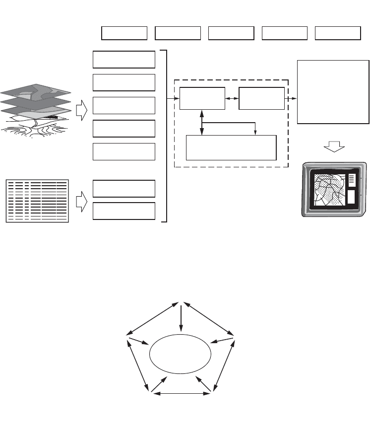
These simple examples identify the key elements of a geographic information system: a base model
that identifies spatial features and spatial relationships, a set of descriptors that can be used to discriminate
and identify individual elements, and a set of functional processes and tools that operate against all
information components. This structure is also shown in Fig. 57.1. Typical bases for application areas
are shown in Fig. 57.2.
FIGURE 57.1
Overview of a geographic information system (GIS).
FIGURE 57.2
Application areas based on geographic information technology. (
Source:
Antenucci et al. 1991.
Geo-
graphic Information Systems: A Guide to the Technology.
Van Nostrand Reinhold, New York.)
Coordinate
Geometry (COGO)
Collect
GIS Overview
Digitized
Maps
Scanned
Maps
Digital Image
Processing
Existing
Digital Files
Keyboard
Entry
File
Transfer
Manage Manipulate
DBMS DBMS
Analyze Display
Land Ownership, Land
Cover, Soil Types,
Transportation, Topography
Tabular Attribute Data
(Non-Spatial)
Map Outputs
Ta bular Reports
Composite Maps
Perspective Maps
Interpretive Maps
Scaled Maps
Areas
Lengths
Summaries
Spatial : Non-Spatial
Data : Data
Base : Base
Maps and Imagery
(Spatial)
Automated Drafting
•
Engineering design
•
Drawing production
Geographic
Information System
•
Spatial analysis
•
Area network modeling
Facilities
Management
•
Plant inventory
•
Work order management
Automated Mapping (AM)
•
Graphic quality
•
Map production
Geoprocessing and
Network Analysis
•
Demographic analysis
•
Address matching
•
Network analysis
Geographic
Information
Technology
© 2003 by CRC Press LLC

Geographic Information Systems
57
-5
57.2 Geographic Information Components
Geography provides a reference for a very large amount of information commonly stored and maintained
in information systems. In many cases this reference or key is not necessarily absolute position or a set
of geographic coordinates, but an indirect key to location such as street address, parcel or property
identifier, phone number, or taxpayer number. One of the distinguishing properties of a geographic
information system is the ability to tie such keys to a common geographic base, such as a basemap
containing streets, property information, and so on. Some common keys for geographic information are
identified in Fig. 57.3.
In fact, the geographic information system is often seen as a focal point for various types of graphical
and nongraphical data collections.
Initially, we can look at these components separately.
Geometry (Graphics)
As previously discussed, GIS has generally evolved from computer graphics systems that allowed the
graphical representation conventionally depicted on map products to be modeled as layers that can be
displayed, edited, and otherwise manipulated by means of specialized software. Today’s CAD systems
still provide the same type of structure. In such a GIS, graphical elements forming a logical grouping or
association are stored on distinct layers or even in separate files. A final graphical display or map output
is formed by switching on or off the appropriate layers of information and assigning to each layer a
predefined cartographic representation designed for the scale of map or specific application. The sym-
bology or line style to be used is traditionally stored with the layer definition, although it is also normally
possible to define special representations for specific graphical elements.
Spatial location is typically stored directly or indirectly within the graphical component of a geographic
information system. In earlier systems a complete GIS project stretching across many map sheet bound-
aries would be stored still in the form of distinct tiles or facets, each representing a drawing with its
original spatial extent. Absolute spatial location in a reference coordinate system, such as a state plane
coordinate system, would be obtained by interpreting for each drawing part a local transformation (a
two-dimensional conformal transformation typically) applied to drawing coordinates. A librarian system
would allow such transformations to be applied transparently to the human operator or indeed to
applications interested only in absolute spatial location.
More recent systems provide a more seamless continuous map base, where geometric components are
stored in a single reference coordinate system that models the real-world representation of geographic
features. Any trimming or splitting of the database to map sheet boundaries or other artificial tiling
systems is more typically completely hidden from anyone but the project manager or system adminis-
trator, as depicted in Fig. 57.4.
FIGURE 57.3
Keys to geographic information.
Key
absolute location X, Y(,Z) coordinates survey monuments
property boundaries
land ownership transactions
ownership
traffic engineering
water/wastewater utilities
demographics
pizza delivery
distance, bearing
alphanumeric
alphanumeric
alphanumeric
alphanumeric
numeric
numeric
relative location
parcel identifier
street address
street segment ID
manhole ID
zip code
telephone number
Type Usage
© 2003 by CRC Press LLC

57
-6
The Civil Engineering Handbook, Second Edition
Attributes (Nongraphics)
As already mentioned, the critical distinguishing property of a GIS lies in its ability to relate various types
of information within a spatial context. Such a context is provided directly through absolute or relative
location or through nongraphic characteristics, also referred to as attributes. Such attributes may act as
direct or indirect keys that allow the analysis of otherwise unrelated sets of information.
We should also distinguish between internally defined attributes or keys that typically maintain the
link between the geometry component and the nongraphic database system. This key is often the weakest
link within a GIS, especially if geometry and attributes are stored and maintained in distinct file or
database systems.
Attribute information is typically held in a relational database management system. GIS applications
typically allow the retrieval of nongraphic and geographic information in a linked fashion. For example,
it is possible to point to a specific location in a graphical map display, to select and identify an individual
spatial feature, and to retrieve or update attribute information relating to this feature. Conversely, it is
possible to select spatial elements on the basis of attribute matching and to display the selection in a
graphical form such as a thematic map. A variety of attribute types are commonly used, as shown in
Fig. 57.5.
Vector
The tremendous growth in comprehensive geographic information systems over the past decade reflects
the implementation of vector-based GIS software systems that can handle a variety of point, line, and
FIGURE 57.4
Map sheets in a GIS. A diagram showing how map sheets stored in separate data files are referenced
within a geographic information system in order to model a continuous spatial extent. Polygon A can be accessed
as a single geographic feature, regardless of where individual segments of boundary lines are stored.
FIGURE 57.5
Typical attribute types.
Map Sheets
GIS Model
A
12-8
13-8
12-9
13-9
Attribute Type
short integer 2 bytes land use class
land value
area
centroid coordinate
street name
property description
scanned image of
building
land purchase date
long integer 4 bytes
floating point real 4 bytes
8 bytes
32 bytes
6 bytes
80 bytes per line
double precision real
fixed length text
variable length text
bulk 30 kbytes for
compressed 256x256
date
Typical Size /
Storage
Requirements
GIS Feature
Example
© 2003 by CRC Press LLC

Geographic Information Systems
57
-7
polygon geometries. Based on these structures, as in Fig. 57.6, all geometric information previously
depicted on hard copy maps could be modeled, stored, and manipulated. Although in earlier systems it
was common to hold a third dimension (the
Z
coordinate or elevation) only as a nongraphic attribute
of the geometric entity, geometric structures in a modern GIS typically hold all three coordinates for
each primitive component. The following geometric structures, also shown in Fig. 57.5, are normally
available:
1. Point or node elements, each containing
X
,
Y
or
X
,
Y
,
Z
coordinates.
2. Line elements, containing or referencing beginning and end nodes, along with a set of intermediate
points, sometimes referred to as shape points. In addition to straight-line connections between
shape points, other primitive line types may be modeled, including circular arcs defined by three
successive points or parametrically (including complete circles) or B-spline connections between
all points in a single entity. Such flexibility in line primitives allows more efficient modeling of
certain types of spatial features: for example, the outline of a building would be defined by
digitizing corner points (vertices) only; a street centerline may be defined using the appropriate
parametric geometry, whereas a digitized contour line may be held for cartographic purposes with
a B-spline connection.
3. Polygons, surface or area primitives, are closed polyline elements used to represent enclosed areas
of the earth’s surface, such as property boundaries, lakes, and so on. A GIS typically allows for
the formation of polygon boundaries based on one or more line primitives and also maintains
special information about “islands” or “holes” within the enclosed area. Such structures allow the
appropriate modeling of, for example, a pond on an island on a large inland lake. As this example
might indicate, more important than the geometric primitives themselves is the overall data model,
including vector-based topology between elements.
FIGURE 57.6
Ve ctor data components (2-D, 2.5-D applications).
Vector Element
node / point
line
line string / polyline
circular arc / circle
spline
complex / composite
line
polygon / surface
Tr iangulated Irregular
Network (TIN)
element
(x
1
,y
1
,y
1
),(x
2
,y
2
,z
2
),
(x
3
,y
3
,z
3
)
(x
1
,y
1
), ..., (x
n
,y
n
) 4-sided polygon
requires 64 bytes
500 triangles require
3600 bytes
digital terrain
model (DTM)
boundary of
municipal service
district
combinations of the
above
combinations of the
above
oddly-shaped
parcel boundary
B
0
,B
1
,B
2
,B
3
coefficients
for each segment
(x
1
,y
1
), (x
2
,y
2
)
(x
1
,y
1
), ... , (x
n
,y
n
)
(x
0
,y
0
), radius,θ
start
,θ
end
20 points require 320
bytes
40 bytes per arc
20 segments require
640 bytes
contour line
curved portions
of roadway
stream
32 bytes service
connection
between house
and utility main
(x,y) 16 bytes (double
precision floating
point)
centroid of parcel
Parameters Typical Size /
Storage
Requirements
GIS Feature
Example
© 2003 by CRC Press LLC
57
-8
The Civil Engineering Handbook, Second Edition
Raster
Some of the earliest computer-based GISs were based on grid-cell information. Before the definition of
more complex structures and the availability of computing power to support their processing, the simplest
way to perform a spatial analysis between multiple layers of information was to subdivide each layer into
a grid of small cells, with an associated numeric cell value which denoted a class or set value representing
the characteristic of that location. By performing simple Boolean operations between the grids repre-
senting each characteristic, useful results could be obtained.
At the same time that raster-based GIS products have been incorporating more vector graphics and
database structures, vector-based products have been providing support for raster information. It is now
possible to display scanned engineering drawings, maps, digital orthophoto products, and other raster-
based imagery, coregistered with vector map information in a common geographic reference system.
This can be seen as part of a broader trend to incorporate both vector- and raster-based structures in a
single software system where spatial analyses may be performed using the most appropriate technique.
For example, cartographic modeling based on raster data allows the simple analysis of such properties
as adjacency and proximity, but processing requirements increase according to the spatial precision or
resolution required. Future software is likely to allow rule-based conversion of information (from raster
to vector, and vector to raster) prior to manipulation, dependent on the specific output requirements.
Topology
The power of a geographic information system lies not only in the data that are held within the system,
but also in the data model that provides the fundamental structure or framework for the data. A basic
component of a vector-based GIS is a set of topologic structures that allows the appropriate modeling
of points, lines, and polygons.
Start- and end-node points of linear elements are often stored as distinct structures, thereby allowing
the analysis of adjacent or connected entities through such logical connections, as opposed to simply a
graphical operation. For example, two lines representing road segments that cross each other may intersect
at an intersection point stored explicitly as an intersection, as opposed to an overpass.
Arc-node topology allows the formation of geometric structures that model elements such as a street
centerline that contains straight-line segments, circular, and spiral curves. In addition, aspects such as
tangency conditions between connected line elements are also considered a part of the topology. During
geometric processing, such as interactive editing, all topology properties would normally be retained or
at least restored after processing.
Polygonal geometry stores its own set of topology, including the element of closure between beginning
and end points of an enclosing boundary. References to islands or holes within the boundary are also
maintained as part of the topology for that feature.
Software tools to create and maintain polygon- and linear-based topology are common required
elements of a GIS.
In a polygon coverage — such as a continuous coverage of soils, land use, or similar — it is often of
value to store such area classifications with line-polygon topology that allows the analysis of shared
boundaries. In such a structure, linear elements that form boundaries between adjacent polygons are
referenced by both polygons. Such a structure also allows common geometry to be stored only once,
allowing efficient storage and maintenance of related information. In a modern GIS it is possible for
single geometric elements to reference not just two areas within a single classification (for example,
adjacent areas of soil), but any real-world elements that refer to the same geometry — for example, a
property boundary that also forms part of the boundary of municipal jurisdictions (tax districts, school
districts) as well as forming a right-of-way boundary.
Another important topologic structure is the composite or complex feature, which allows the grouping
of logically related graphical and nongraphic elements. This extends the power of a GIS beyond simple
relationships between a single spatial element and one set of attributes to a more sophisticated modeling
© 2003 by CRC Press LLC