Wai-Fah Chen.The Civil Engineering Handbook
Подождите немного. Документ загружается.

High-Speed Ground Transportation: Planning and Design Issues
60
-5
•The love of Americans for the automobile
•The advances of the airline industry and the economic power of airline companies (which is
questionable after the 2001 terrorist acts in the United States)
•The size of the U.S. landmass in conjunction with its population density
•The skepticism of generating enough demand for a profitable venture in any but the highest
population corridors
•The lack of a passenger railroad culture
Concerns over gridlock, wing lock, negative environmental impacts, and the failure of airports to
expand to fully meet commuter demand, coupled with the successes of HSGT in Europe, have brought
about a resurgence of interest in high-speed passenger rail traffic. The HSR is most likely to succeed
between cities with stage lengths in the range of 200 km (125 miles) to 400 km (250 miles), where it can
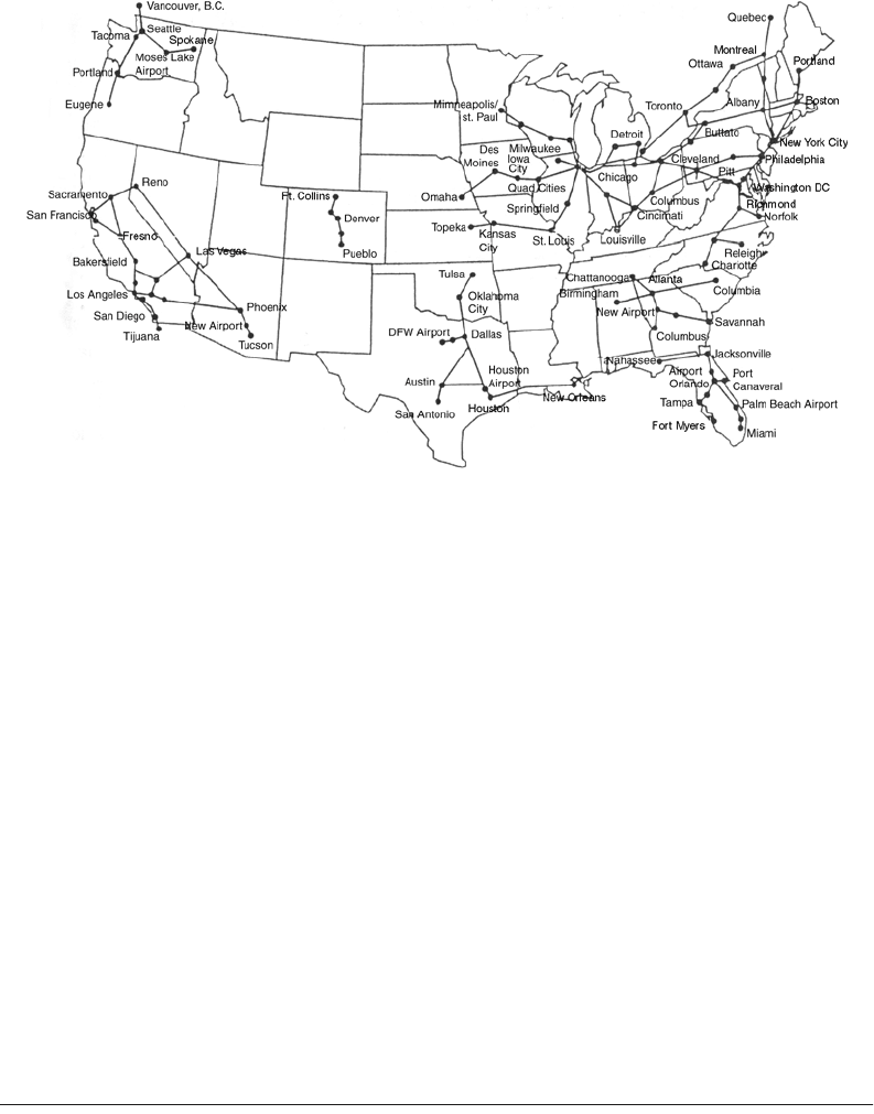
be competitive with airline connection [12]. The map in Fig. 60.4 indicates the leading candidates for
HSR or MAGLEV consideration in the United States. HSGT systems could free capacity at some of the
congested highways, air space, and airports. Moreover, it is a mode of transportation that appears to be
reasonably energy efficient when compared with other modes; with electrification for its power source,
it is potentially less dependent on petroleum resources [23,24].
60.2 Systems and Planning Issues
Because of its years of revenue service in Europe and Japan and because it has continued to achieve
growth and implementation worldwide, HSR should be considered a mature technology that might be
expected to find its way quickly and easily into operation in the United States. In fact, an Amtrak-operated
HSR train, called ACELA, has served the Northeastern U.S. corridor (NEC) since 1999 [12], connecting
Boston, New York, Washington, D.C., and Philadelphia — getting around 45% of the passenger market
between Boston and New York and cutting the travel time of 4 h 30 min to about 3 h [12]. In California
and 20 other states, plans are made to implement HSR along corridors [25]. On the contrary, in Texas
FIGURE 60.4
HSGT systems under study in the United States. (From U.S. Government Accounting Office, Report
to the Chairman, Committee on Energy and Commerce, High-Speed Ground Transportation: Issues Affecting
Development in the United States, House of Representatives, November 1993.)
© 2003 by CRC Press LLC
60
-6
The Civil Engineering Handbook, Second Edition
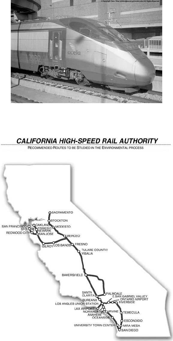
FIGURE 60.5
Photo of the ACELA Express. (From French TGV web information (TGVWeb), mercu-
rio.iet.unipi.it/tgv, Italy, 2001.)
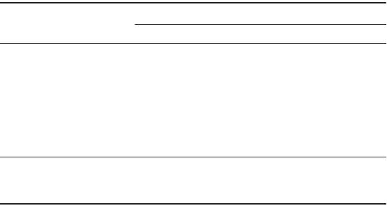
FIGURE 60.6
The proposed California HSGT network — environmental progress. (From CalHSR.)
© 2003 by CRC Press LLC
High-Speed Ground Transportation: Planning and Design Issues
60
-7
and Florida such plans proposed in the past years were either abandoned or cancelled [12,17,18]. The
initial notion, though, still requires exploration in three major areas:
1. When, how, and who will provide leadership to back high front-end costs in the face of widespread
skepticism and competitive pressure? For example, the proposed HSRs to serve major corridors
in Texas and Florida were abandoned [12,17,18]. Pointed opposition of local airlines (Texas) [12],
difficulties in raising funds [17], negative public opinion [18], and studies that questioned the
effectiveness of HSR (for example, the Wendell Cox Consultancy Report regarding the HSR
implementation in Florida, issued by the James Madison Institute (JMI) in 1997) were major
reasons for not continuing projects of implementing HSR trains in the United States. On the
contrary, in other cases (Northeastern corridor, California, etc.) plans and implementation of HSR
are being developed, having obtained necessary funds and support [25].
2. Can potential projects in the United States secure right-of-way with adequate space to meet HSR
requirements of track geometry and provisions for electric power supply and catenary? The answer
to that question is mainly related to the special characteristics of the studied corridor. An example
of the meeting of the above requirements by an HSR in the United States is ACELA, operating in
the Northeastern U.S. corridor. NEC was electrified up to Boston by 1999, while tilting technology
(which will be discussed later) was used to operate HSR in existing tracks without passenger dis-
comfort [12,14]. Despite some technical glitches, ACELA began operating in December 2000 [14].
3. Will all the safety concerns, many of which reflect the difference between American philosophy and
that of Europe and Japan, be met without significantly reducing the speed of the trains? The
American philosophy toward safety is less flexible in most cases, so additional measures are to be
taken in the train sets, signaling, and control systems to ensure maximum safety. The fact that HSGT
corridors in Europe and Japan are fenced and thus inaccessible, something that is not happening in
existing rail corridors of the United States, is something that also has to be taken into account [12].
The most important characteristic in an HSGT system is usually average speed [26]. Average speed
affects travel time that has to be decreased, compared to other competing modes, and capacity that has
to be increased. As average speed is critically important, the parameters that affect it should be examined.
They are as follows:
•The HSR train’s ability to negotiate curves
•The HSR train’s ability to accelerate and decelerate quickly
•The number of station stops en route and dwell time at each station
Besides travel speed, there are a number of system considerations and performance characteristics that
should be used in evaluating HSGT systems. These include travel demand, corridor development, sched-
ule performance, acceleration and deceleration, ride quality, noise, safety, energy conversion efficiency,
system-wide parameters, and air–rail combination possibilities.
Market Demand
The cost of the investment of most HSR systems is high, and the introduction of an HSR system will
require a thorough and positive market analysis. Since it impinges on the commuter air market and the
automobile–bus vehicle market, its potential entry as a competitor may be difficult to judge. In addition,
there will be a latent demand for HRS travel that will become part of the demand picture.
For example, Table 60.1 shows that the French have succeeded in shifting traffic from the air and
highway and in generating new demand with the initiation of the TGV operation from Paris to Lyon
(with other nearby cities, served by standard rail). Analysis of the growth in the Paris-to-Lyon market of
2.2 million passengers from 1980 (pre-TGV) to 1994 indicates that 40% of the passengers have been
diverted from commuter air, 23% from auto, and 37% are new or induced demand [12,14,16].
© 2003 by CRC Press LLC
60
-8
The Civil Engineering Handbook, Second Edition
How will the U.S. public respond to the placement of an HSR system in a given area? Will people give up
their autos for these trips? Is there an adequate market in these days of electronic mail and teleconferencing?
Will the public accept rail with trip times from origin to destination in the same range for commuter air?
These are questions that must be answered. Without adequate answers and without a strong infusion
of capital from the federal government to help construct the expensive facilities, HSR or MAGLEV will
probably not reach any significant level of implementation in the United States. At the time, there is no
actual data regarding HSR influence on market demand. Studies on future market demand have been
conducted for California, Florida, and other cases in the States [17,27]. Especially in Florida, two
controversial studies have been conducted, one attempting to reject the other.
California HSR Case: Expectations of the Final Plan of HSR Implementation
in the State [25,27]
The market for intercity travel in California is projected to grow up to 40% by 2020 (population expected
to grow about 36%) [25,27]. Today’s 154 million trips will grow to up to 215 million trips by 2020. The
forecast for HRS is that it will be serving around 32 million passengers and gain $888 million (assuming
86 HSR trains per day in both directions). This is expected to cover operating costs and produce a surplus
of $340 million. These numbers are based on current parameters like cost of travel for each mode and
travel times, a scenario considered conservative. Sensitivity analysis showed that by assuming negative
changes in these parameters, the revenue for HSR might be doubled, while an additional 10 million
passengers will be using the HSR every year. The HSR is expected to gain 45% of its ridership from air
transportation and 42% from auto transportation. The rest will be new passengers produced because of
the presence of the new mode.
The study compares key elements for mode selection. For example, total travel time is in favor of the
HSR (total travel time includes waiting time, time to access mode terminals, etc.). As for fares, the HSR
is expected to generate maximum surplus revenue, with fares 20 to 30% lower than airfares. In addition,
according to the study, the quality of HSR seems to be more attractive for users compared to auto or air
transportation.
It should be noted that the study takes into account uncertainties in the results of projection, especially
in the first years of the HSR operation. Therefore, a reduction of 15%, annually reduced, is taken into
account (supposing that HSR will start operating in 2017 with an 85% ridership of the projected one).
The above and other facts were drawn from the study. Sensitivity analysis was conducted, taking into
account increased airfares, auto growth rates, longer air or auto travel times, and combinations of the
above scenarios. The sensitivity analysis showed that increases in airfares have a significant impact in
HSR, while travel times have only modest impacts [25,27].
TA BLE 60.1
Passenger and Traffic Demand for the French TGV:
Paris-to-Lyon Route
Tr avel Demand (thousands of passengers), Paris to
Dijon Geneva Lyon Grenoble Marseilles
1980 train 850 105 1470 435 720
1994 train (TGV) 1045 325 3670 710 1005
% increase 23% 209% 150% 38% 40%
1980 airplane 605 970 515% 1480
1994 airplane (after TGV) 495 525 280 1195
% increase –18% –46% –46% –24%
Probable Diversion from
Plane 165 865 40 165
Road 50 20 500 65 50
Induced traffic 145 35 835 90 70
Source:
Te xas TGV, Franchise Application,
submitted to Texas High-Speed Rail Author-
ity, 1991.
© 2003 by CRC Press LLC
High-Speed Ground Transportation: Planning and Design Issues
60
-9
The major conclusion of the study is that, despite that HSR will not be the dominant mode of intercity
transportation in most cases, the fact that it will be economically viable makes it applicable to California.
Florida HSR Case: Two Opposing Studies
Since 1991, the Florida DOT (FDOT) has initiated studies of implementing HSR in Florida, with the
potential of partial public funding [17,18]. In 1995, FDOT asked for proposals by private companies for
financing, operating, and building an HSR system along the Miami–Orlando–Tampa corridor. Five
companies offered proposals, from which Florida Overland Express (FOX) had the winning proposal,
mainly because of its better financing plans and the fact that the company fulfilled the requirements
regarding environment, safety, technology, etc. set by FDOT.
FOX had developed an analysis in 1995 to support its proposal along the Miami–Orlando–Tampa
corridor, including ridership, building and operating costs, and financing of the project. The ridership
analysis was revised by FOX and FDOT later in 1998, only to find increased projected ridership.
In 1997, a report prepared by Wendell Cox Consultancy [17] and issued by the James Madison Institute
questioned the accuracy and results of the FOX market analysis, concluding that HSR would carry fewer
passengers than the FOX market analysis expected and would cost more and expose taxpayers because
of that. The Cox analysis asserted that the ridership forecast was incorrect (unreliably high for the HSR
part), as were the air and HSR fare forecasts. The Cox analysis concluded that the FOX project had an
incorrect market analysis (in terms of forecasting) and, thus, its financing plan would not be achievable
and would be costly to taxpayers. Comparisons with FRA-forecasted numbers for ridership and fares and
the economic condition of HSR companies in Europe were additional facts in the Cox analysis. The result
of the confrontation was in favor of the Wendell Cox Consultancy study; in 1998 the governor of Florida
cancelled the FOX project.
Chicago–Milwaukee: Twin Cities Corridor Study [28]
For the Twin Cities corridor study, fairly conservative demand models were developed, examining three
scenarios (125-, 186-, and 300-mph systems). It was revealed that the 125-mph option offers the best
financial return, the fewest environmental costs, and the highest economic benefit per dollar invested,
which would be relevant to a public sector capital-constrained investment program. While the net
economic benefits are not quite as high as with the 185- and 300-mph options, the level of benefit is
substantial. The economic benefits achieved by the 125-mph option are 80% of those achieved by the
185-mph technology and 94% of those achieved by the 300-mph technology. The 185-mph technology
(TGV) has a good financial return and the highest net economic benefits, but it suffers from the highest
environmental costs because of the severance problems associated with its new right-of-way. The 300-
mph technology (MAGLEV) provides good economic benefits but has only marginal financial perfor-
mance due to its substantial capital costs. What is surprising is that the 300-mph option performs as well
as it does, given its huge capital costs.
Corridor Development
The corridor for HSR will require either an upgrade of existing track or new land acquisition coupled
with the construction of straighter track, built with the stability in alignment required for these speeds.
This may not be so easy, since the corridor will bisect farmers’ fields and create dead ends for many rural
roads. The corridor would also require rerouting of utility service lines such as gas, water, sewer, telephone,
and electricity.
At the speeds of the HSR, grade separation is necessary, so overpasses and underpasses will be required
in many areas. For some farms it may be necessary to put an access tunnel under the roadbed in order
for the farmer to get from his fields on one side of the track to those on the other. For example, the 458 km
between Fort Worth–Dallas and Houston is estimated to require 270 bridges over creeks, rivers, highways,
and other railroads, plus about 25,000 m of elevated track, mostly in the urban areas. Also needed would
be about 145 culverts (10
¥
10
¥
150 ft) for drainage and access along the same right-of-way [15].
© 2003 by CRC Press LLC
60
-10
The Civil Engineering Handbook, Second Edition
Small towns also pose problems to an HSR corridor. If the use of the present ROW is suggested, much
of that ROW passes through small towns and other lightly populated areas. The choice and the placement
of the corridor, the approach to tunnels, and the design of other depressed or elevated ROWs around
these towns may significantly increase the cost of the investment. Most of these towns will not have a
station, since the train won’t be able to stop frequently in order to take advantage of the higher peak
speed. Therefore, the economic development aspects, which classically occur around stations, will not
take place and the towns may see the HSR only as a nuisance.
Entering large urban areas may be easy or difficult, depending on the existing roadbed. The TGV,
operating at reduced speeds, uses existing track for entry and exit of Paris and Lyon [12,21].
The corridor chosen may require some tradeoff between the cost of wetlands remediation (if wetlands
are in the path of the HSR corridor) and alternate routes that require less or no mitigation.
There is no doubt that access of ROW for a corridor, whether through procurement, eminent domain,
or condemnation, must occur very early in the project — well before any construction is due to begin.
With the corridor disruption or “severance” of farms or landscape, the HSR will face the usual uphill
battle from those who do not want the railroad. The “Not in My Backyard” (NIMBY) syndrome will in
all likelihood be very prevalent.
An example of a corridor study for HSGT implementation is the Chicago–St. Louis High Speed Rail
Study, completed in August 2000 by the U.S. DOT, FHWA, FRA, and Illinois DOT [28]. For the corridor
study, two major alternatives were examined: (1) the “do-nothing” alternative, where the existing Amtrak
service would remain with the regular maintenance and rehabilitation actions on the corridor and (2) an
HSR train implementation as a more viable solution, compared to air and auto travel. The HSR would
operate at speeds of 110 and 125 mph and would consist of 8 round trips per day, every 2 hours, with
a travel time of around 3.5 h. Existing tracks would be used and, in addition, new tracks would be
constructed to facilitate the HSR performance. Three different alignments were proposed for the HSR
implementation. Also, different types of train sets (electric or diesel) and different operating speeds were
examined; 110 mph was chosen as the most cost effective. The evaluation of the different alternatives
examined land use and farmland; displacements; and effects on employment around the corridor, on
water and natural resources, and on wetlands and floodplains, as well as effects on cultural resources,
waste, and grade crossings. Special care was taken for the accommodation of grade crossings and effects
when crossing small cities. Also, unresolved problems remained, concerning other agencies as well, for
the disposal of waste, the treatment of historical properties, air quality issues, etc.
Cost Estimate
The Transportation Research Board has developed a series of cost estimates based on several HSGT
scenarios [30]. The scenarios compare several options against an “as is” railroad. The options for which
data are presented in Tables 60.2 and 60.3 are:
TA BLE 60.2
Estimates for Six Alternatives of HSGT: 300-Mile Corridor
Alternative
Urban Track,
40 Miles,
Cost per Mile
Suburban Track
60 Miles,
Cost per Mile
Rural Track,
200 Miles,
Cost per Mile
Total System,
300 Miles,
Total Cost
1 $915,000 $400,000 $235,000 $108,000,000
2 $1,660,000 $1,000,000 $740,000 $275,000,000
3 $7,645,000 $6,410,000 $5,260,000 $1,742,000,000
4 $7,680,000 $7,370,000 $8,340,000 $2.418,000,000
5 $8,110,000 $14,490,000 $10,495,000 $3,293,000,000
6 $31,115,000 $19,715,000 $14,055,000 $5,239,000,000
Source:
Parsons Brinckerhoff Quade & Quade, Inc., High-Speed Surface Transpor-
tation Cost Estimate Report, TRB, Washington, D.C., April 1991.
© 2003 by CRC Press LLC

High-Speed Ground Transportation: Planning and Design Issues
60
-11
1.
“As is” railroad
requiring a typical class-3 track to be upgraded with the addition of block signaling
and passing sidings to permit 125-kph (79-mph) passenger service.
2.
Low ROW/capital investment strategy
with top speeds of 175 kph (110 mph) and upgrades in track
and cab signaling. ROW width sufficient for second track and major rehabilitation at stations.
3.
Intercity/shared ROW
would have top speeds of 200 kph (125 mph) with electric propulsion, a
full double track, and concrete ties maintained to FRA class-6 standards. All high-speed crossings
would be grade separated.
4.
Intercity/shared ROW/new bypass segment
with one to several bypass segments with track geometry
and signaling to permit top speed on the bypasses of 240 kph (150 mph).
5.
The TGV approach
with trains operating mostly on new ROW dedicated to the TGV with top-
speed operation in the 290- to 320-kph (180- to 200-mph) range.
6.
New technology using MAGLEV
concepts with a top speed of 500 kph (320 mph).
The TRB presents many assumptions on which the above numbers are based. However, for the purpose
of planning, these numbers should be sufficient for preliminary estimation. The costs include land, ROW
preparation, utilities relocation, track construction, realignments, grade separations and enclosures,
fencing, electrification, signaling, undergrade bridges, overhead bridges, tunnels, terminals, beltway
stations, O&M, central control administration, and train sets. The assumptions are given in sufficient
detail so that a quick estimate can be made. The costs for a 500-km (300-mile) system with 67 km
(40 miles) of urban land, 100 km (60 miles) of suburban land, and 333 km (200 miles) of rural land are
presented. The average cost for the TGV (option 5) is about $6.84 million per kilometer ($11 million
per mile) [30,31].
Schedule Performance
Providing that the ride quality is acceptable, the demand for the HSGT will depend on the perception
that the consumers have as to its schedule performance and reliability. When comparing the HSGT with
competing modes, the actual travel time for the user between origin and destination is critical. The line-
haul speed, typical average speed, and time of trip are given in Table 60.3 for the six alternatives shown
in Table 60.2.
Somewhat higher speeds than those quoted for alternatives 3 and 4 may be obtained if an active tilt
train such as the Swedish X2000 or EGR 460 is used. [12,32–34].
The speed of the train on curves will
depend on the radius of the curve, the superelevation of the track (bank angle), and the allowable
deficiency in the cant angle — the limits for which come from ride comfort (lateral forces on passengers).
A train, such as those in alternatives 2 to 4, that must regularly slow down for curves and then accelerate
again will have a slower overall line-haul speed than one that can negotiate the curves at or close to its
regular speed. Improved acceleration and braking are aided by lower train set weight achieved through
the use of lightweight materials and appropriate construction techniques.
TABLE 60.3
Speeds and Trip Times for the Six Scenarios
Alternative
Urban Track,
40 Miles,
Speed (kph)
Suburban Track
60 Miles,
Speed (kph)
Rural Track,
200 Miles,
Speed (kph)
Total Trip
Total Time
(h)
Average Speed
(kph)
15065704.58 65
25080903.77 80
35590903.39 88
45590130 2.93 102
560100 150 2.60 115
6 100 170 230 1.62 185
Source:
Parsons Brinckenhoff Quade & Quade, Inc., High-Speed Surface Transportation Cost
Estimate Report, TRB, Washington, D.C., April 1991.
© 2003 by CRC Press LLC
60
-12
The Civil Engineering Handbook, Second Edition
The number of stations and the dwell time in each station will also affect the overall time of travel
between two points. Analysis of the TGV on one 400-km (250-mile) route with a maximum line-haul
train speed of 300 kph (186 mph) and stops at four intermediate stations, each with a dwell time of
3 min, had 118 min of elapsed time from doors closing at the origin to opening at the final destination.
The average speed was 204 kph (127 mph).
Safety
The potential severity of higher-speed accidents can be offset by such factors as dedicated right-of-way,
fully fenced corridors, automatic train control, and ROW maintenance — all geared to reduce the overall
risk. A large part of the research regarding HSGT systems has focused on safety issues [35–38].
Many of
these issues deal with crash tests and car designs that will minimize bodily injuries in case of a crash.
The existing HSGT systems in Europe are operating at a level of safety that is better than that of
conventional rail technology. The excellent system maintenance, highly automated train control, dedi-
cated ROW, and fencing around the tracks have led to an amazingly safe accident record. For example,
the Japanese Shinkansen line has had no fatal accidents in the past 18 years while having transported
approximately 2 billion passengers [24,43]. The same applies to the TGV: while operating at high speeds,
no fatal accidents have happened since it began service in 1981. In fact, within the last 20 years of TGV
service, only 11 incidents have occurred, the most important of which occurred in the conventional lines,
where the speeds were lower and any conventional train had the same chances of facing such an incident.
Table 60.4 shows the incidents and the dates they occurred. The most serious accident concerning an
HSR train within the last 20 years of HSGT operation in Europe happened in 1998, when a German ICE
1 HSR-type train derailed on a highway bridge abutment at a speed of 200 kph and caused the bridge
to collapse, as well. The accident caused the death of 88 passengers and injury of at least another 100
and forced the German government to operate its ICE trains at lower speeds for a long period [12,13].
The cause of the crash was the cracking of a defective wheel [12,13].
Higher-speed operations on existing lines pose an especially difficult problem. The track, ballast, and
geometry are all designed to accommodate lower speeds. There will certainly be increased risk associated
with the use of this track in high-speed operation. In fact, the use of an existing ROW such as in the
Northeast corridor is what happened in the United States. With the large amounts of capital needed, it
is clear that until the federal government decides to fund dedicated ROWs, the upgrading and increased
use of existing ROWs will be the direction higher-speed rail takes in the United States (Next Generation
Rail, Accelerail, Incremental Rail, or whatever one wants to call it). With this use comes the need to assess
how ROW and equipment design, signal systems, onboard and wayside detectors of various sorts, grade
crossings, ROW security, etc. contribute to enhancing the overall safety risk, given the accident severity
potential that inherently increases with speed. Such progress is achieved by using other system elements
to control risk to the same or lower levels than is currently accepted by the riding public [44,45]. The
TRB IDEA program suggests several areas of study regarding the safety of HSGT [5], focused mainly on
upgrading the existing ROWs.
This leads to a careful design of an onboard monitoring system that will automatically slow a train
that is starting to hunt. The elements with automation will include accelerometers to detect the onset of
truck hunting, bearing temperature monitors, brake system sensors, various wayside detectors, etc. [5,7].
As speeds increase above 200 kph (125 mph), dynamic force control is a key factor in maintaining
safety of operation. New inspection methodologies to move from the currently accepted static geometry
(even if loaded) measurements to more dynamic real-time monitoring of equipment forces (wheel) and
the track response and interaction (rail) are needed for the HSR. The whole issue of maintaining track
for ride comfort versus minimum track geometry standards must be addressed [47,48].
Lighter weight but stronger materials will be required (one key to the success of TGV and ICE), while
it will be appropriate to maintain or reduce, not increase, axle loads. Thus, given the United States’ need
to design for different collision scenarios (mixed freight and passenger operations), the challenge to be
innovative will be even greater. (Even though the TGV and ICE trains in some cases do operate on existing
© 2003 by CRC Press LLC

High-Speed Ground Transportation: Planning and Design Issues
60
-13
or shared ROWs, as well as on dedicated lines, the type of freight equipment and thus accident scenarios
are different from those in the United States). Given some of the accidents France and Germany have
had between “regular” passenger trains and freight trains and their resultant severity, one could argue
that such risks would not be acceptable to the U.S. riding public.
Studies have also been made for the fire safety [49], emergency preparedness [50], control, commu-
nication [51,52], the human factor, and automation as they apply to train control [53].
Finally, there is considerable concern over the effects on health of electromagnetic field (EMF) radi-
ation. The FRA, through the Volpe National Transportation Systems Centre and the Environmental
Protection Agency, has done considerable testing and analysis of this potential, both for the TGV-type
train and the MAGLEV train. A series of 17 reports [54]
is available on the subject.
Noise
Since HSGT is to be powered by electricity, air pollution is not a factor, leaving the major environmental
considerations: severance of land, wetland mitigation, and noise. The National Environmental Policy Act
of 1969 requires that any project with federal government involvement be accompanied by an environ-
mental impact statement. Certainly the choice of a corridor is critical, as it may require wetland mitigation
and the HSR noise can have an effect on the land use along the corridor. Fortunately, the HSR noise
seems to be less than the noise associated with conventional rail operations [55–57].
TA BLE 60.4
Incidents since TGV Started Service
Date Cause Train Set Involved Service Location Injuries
05 January
2001
Derailment Atlantique,
unknown
Tr ain 8720, Brest to
Paris
Standard line near Laval
(Mayenne)
None
05 June 2000 High-speed
derailment
Eurostar
3101/3102
Tr ain 9047, Paris to
London
LGV Nord Europe, near
Croisilles (10 km south
of Arras)
14, slight
28 November
1998
Grade-crossing
accident
Atlantique,
unknown
Unknown, Brest to
Paris
Grade crossing 303, near
Guipavas (29)
None
9 May 1998 Grade-crossing
accident
4345 (Thalys
PBKA)
Tr ain 9344,
Amsterdam to
Paris
Hoeven, southern
Netherlands
6, slight
19 November
1997
Grade-crossing
accident
Atlantique,
unknown
Brest to Paris,
unknown
D140 road at Neau, near
Laval
6, slight
11 October
1997
Fire PSE, 15 (or 45?) Train 644, Lyon to
Paris
Near Montchanin, LGV
Sud-Est high-speed line
None
25 September
1997
Grade-crossing
accident
502 (Réseau) Train 7119, Paris to
Dunkerque
Bierne (10 km south of
Dunkerque)
7, slight
10 August
1995
Grade-crossing
accident
394 (Atlantique) Train 8737, Paris to
Brest
Near Vitré, kilometer
post 342, PN 172 grade
crossing with road D34
2, slight
21 December
1993
High-speed
derailment
511 (Réseau) Train 7150,
Valenciennes to
Paris
TGV Haute Picardie
station, kilometer post
110.5, LGV Nord
(Paris-Lille) high-speed
line
1, slight
14 December
1992
High-speed
derailment
PSE, unknown Train 920, Annecy
to Paris
Mâcon-Loché TGV
station, kilometer post
334, LGV Sud-Est high-
speed line
27, slight
23 September
1988
Grade-crossing
accident
70 (PSE) Train 736, Grenoble
to Paris
PN 74, Voiron 2 dead,
60 injured
31 December
1983
Te rrorist
bombing
PSE, unknown Unknown, Marseille
to Paris
Near Tain-l’Hermitage,
south of Lyon in the
Rhône Valley
Source:
Chemins de Fer, La Vie du Rail, TF1 television, Dernieres Nouvelles d’Alsace, U.S. Federal Railroad Administration, etc.
© 2003 by CRC Press LLC
60
-14
The Civil Engineering Handbook, Second Edition
Given that noise increases with speed, due to the high aerodynamic component, the need for either
passive barriers or active noise canceling systems becomes apparent [46].
The major noise sources in diesel operations are the engine and the interaction of the steel wheel on
steel rail. The noise levels from pre-1987 diesel locomotives vary from 67 dBA at idle to 89 dBA at full
throttle when standing 100 ft from the locomotive [55]. The wheel–rail noise levels vary dramatically
according to the type of wheel and track structure. Most irritating is the track squeal resulting from
lateral sliding of the wheels. Wheel–rail noise is usually computed as a function of the speed of the train.
Likewise, the noise experienced by rapid rail transit is attributed to the electric engine, which is much
quieter than its diesel-driven counterpart and the rail–wheel interaction. The noise level for the
San Francisco Bay Area Rapid Transit System (BART) at 60 mph is approximately 83 dBA 50 ft from the
train; the corresponding diesel noise is 97 dBA [55].
The Japanese Shinkansen has been in operation since 1964 and has provided much noise data. The
noise level measured at 15 ft from the train varies from 62 dBA at 118 mph to 76 dBA at 124 mph. The
French TGV showed noise somewhat higher when operating on its Paris–Lyon route. However, 72 dBA
was exceeded at only three homes along the route, and the maximum noise measure 82 ft from the train
was 97 dBA. The German ICE reported noise levels of 86 dBA at 11.5 ft from the train travelling 124 mph
and 93 dBA at 186 mph.
Care in design will keep the noise at these relatively low levels. With noise barriers provided by either
trees and shrubs, constructed walls or depressed track, the noise of the HSGT should be well below any
sound levels that would pose an annoyance to neighbors.
Ride Quality
In addition to the stress on performance, the consumers will ride the HSGT only if, as passengers, they
perceive it to be comfortable. Thus, ride quality as experienced in the seat design and in the amenities
is quite important. Although ride quality is subjective in nature, the train set appearance, both interior
and exterior, lighting, sound levels, airflow, and temperature determine the appeal. Most of the European
trains also provide places for small meetings, phone and fax service, special workspaces including com-
puter hookups, and real-time trip-related status information.
Physical ride quality is determined by track design and alignment, car body motion, and the design
of the passenger seats. The track input comes from the track itself: is the rail continuous and is it aligned?
Most of the high-speed lines maintain track to achieve lateral and vertical forces and acceleration levels
low enough to assure good ride quality. At present International Standards Organization (ISO) standards
for ride quality do exist. From a vehicle point of view, dynamically balanced wheel sets, wheel profile,
and low unsprung mass are considered the strongest influences for best ride quality [58]. Low unsprung
mass is essential for truck stability, while the suspension must be designed to minimize lateral and vertical
movements of the car body. Wheel profile is important in maintaining safe levels of wheel–rail interaction
forces to ensure a smooth and comfortable ride. In summary, ride comfort is very subjective, and each
railway authority develops its own criteria.
So important is riding quality that sensors and a computer are employed on many trains to give a real-
time measure of ride quality and to make adjustments or signal the engineer as necessary. Furthermore,
these data may be used to indicate portions of the track for special maintenance. Such a maintenance
philosophy dramatically reduces the likelihood of encountering unsafe levels. The TGV uses truck-
mounted accelerometers to detect truck hunting and requires immediate reduction in speed if such
hunting is detected.
Energy Conversion Efficiency
Energy use by the train is important, and one of the goals of the HGST systems is to conserve energy to
minimize operating cost. Energy efficiency is a function of the propulsion system, gearing, and train set
design. The Federal Railroad Administration, through the Improved Passenger Equipment Evaluation
© 2003 by CRC Press LLC