Gates A.E., Ritchie D. Encyclopedia of Earthquakes and Volcanoes
Подождите немного. Документ загружается.

Advanced National Seismic System (ANSS) In response
to the severe seismic risk that Americans are exposed to in
many areas of the country, the U.S. government established
the ANSS. This program provides accurate and timely data
as well as information on seismic events, including the effects
on buildings and other structures. The ANSS is a basic func-
tion of the National Earthquake Hazard Reduction Program.
When the system is complete, it will have some 7,000 seismic
stations, with dense concentrations at 26 designated high-risk
urban centers. Functions of the ANSS include constant moni-
toring of seismicity, thorough analysis of seismic events, and
automatic broadcasts of potential seismic hazards, all in real
time.
Aeolian Islands See Lipari Islands.
Aeseput (Aeseput-weru) See Tondano.
Afghanistan Although it is one of the more seismically
active countries in the world, the lack of accurate records
makes reporting on Afghanistan’s historical earthquakes dif-
ficult. Recent earthquakes have been better reported, such as
the Rostaq and Mazar-e Sharif earthquakes of 1998 and
the series of earthquakes of 2002 during the U.S.–Al Qaeda
conflict. Prior earthquakes are said to have killed as many
as 20,000 people in a single event, but information is largely
conflicting. The seismic activity results from the position
of Afghanistan as a promontory of the Eurasian crustal
plate pushing southward into the Indian and Arabian
crustal plates. The southern boundary of Afghanistan is
marked by deep earthquakes associated with the subduc-
tion of the Arabian plate beneath the Makran Coast. Both
the western boundary with Iran and the eastern boundary
with Pakistan have a long history of intense seismic activity.
Fortunately, the central part of the country is less active. The
exception is the active Chaman Fault, which shows a seismic
gap near Kabul. If it produces a major earthquake, it could
be devastating.
Africa The African continent has areas of strong seismic
and volcanic activity. Much volcanism and earthquake activ-
ity is concentrated along Africa’s Great Rift Valley, which
extends through the eastern portion of the continent and
contains numerous volcanoes and calderas. The East Afri-
can Rift is the third arm of a triple junction that includes
active arms of the Red Sea and the Gulf of Aden. Africa is
also moving north relative to Europe. A subduction zone
in the Mediterranean Sea produces earthquakes and vol-
canoes that cause tsunamis that affect the north coast of
Africa. The Betic Zone largely lies in Spain but also affects
the nearby African coast. Volcanoes and volcanic deposits
of Africa include Asawa, the Barrier, Cameroon, Corbetti,
Deriba, Fantale, Kilimanjaro, K’One, Land of Giant Craters,
Ngorongoro, Nyamulagira, and Nyos.
aftershocks Earthquakes less intense (weaker) than the
main (strongest) earthquake. Aftershocks can be determined
only in retrospect. Typically, seismic events begin with
foreshocks, followed by the main shock and finally after-
shocks. For example, if a magnitude 6.4 earthquake occurs
after a series of foreshocks, it could be the main shock; all
succeeding earthquakes would be aftershocks. If a magnitude
7.4 earthquake occurs three earthquakes later, then the 6.4
earthquake was merely a strong foreshock, and aftershocks
only start after the 7.4 earthquake. Aftershocks may continue
for weeks or months after the main shock and be nearly as
powerful. They tend to be quite destructive to property, as
they can topple structures left unstable by the main shock.
In the North Ridge earthquake of 1994, strong aftershocks
continued for a year after the main shock. They had a ter-
rifying psychological effect on the populace of Los Angeles,
California.
Agadir earthquake, Morocco The earthquake of February
29, 1960, struck the community of Agadir with a popula-
tion of 33,000 at the foot of the Atlas Mountains at 11:45
p.m. It killed some 12,000 people and injured 12,000 oth-
ers. Destruction of the old part of the city was complete, and
some 70% of the new structures in the city were destroyed.
The earthquake measured 6.25 on the Richter scale of mag-
nitude and was preceded by two milder shocks. The earth-
quake was also accompanied by a tsunami that reached
almost a hundred yards inland from the sea. Effects of the
earthquake included ruptured sewers, from which large num-
bers of rats were reportedly released into the city. The earth-
quake neutralized the city’s fire-fighting capability, with the
result that fires burned unchecked. The dome of a mosque
collapsed on a group of praying Muslims, and the Jewish
community of Agadir was devastated; of some 2,200 Jews in
Agadir, approximately 1,500 were said to have died in the
earthquake. Corpses were so numerous in Agadir after the
earthquake that most of the 12,000 dead were simply buried
in common graves, using a bulldozer.
The reasons that this earthquake was so devastating were
threefold. First, the focus of the earthquake was very shal-
low (less than two miles [3 km]). Typically, the energy from
a deep earthquake is already spread out and somewhat dif-
fuse by the time the waves reach the surface. In this case, the
energy was still concentrated so it was more destructive than
many earthquakes of higher magnitude. Second, the epicen-
ter was right in the middle of the city. The zone of highest
potential destruction was in the worst possible place. Third,
the city was totally unprepared for the earthquake. There had
been a very destructive earthquake in Agadir in 1751 (more
than 200 years earlier) but only minor seismic events since.
agglomerate A chaotic jumble of mixed sizes and types of
pyroclastic material (ejecta) that is lithified into a rock.
An agglomerate is typically formed close to a volcanic vent
where the power of the eruption can pulverize the exist-
ing rock and dump it into a deposit. They indicate very high
energy and must include a large component of bombs and
blocks.
Agnano volcano, Italy The Agnano volcano formed a cra-
ter in the Phlegraean Fields near Naples. The crater once
was filled with a lake but later was drained and converted
into a racetrack.
2 Advanced National Seismic System
Agua de Pau caldera, Azores The stratovolcano Agua de
Pau has a record of historical activity extending back to 1563,
when an eruption of pumice reportedly covered the nearby
island of São Miguel. Strong earthquakes preceded and con-
tinued during the eruption and destroyed most of the commu-
nity of Ribeira Grande, several miles north of the Agua de Pau
caldera. basalt lava extruded from the volcano following the
eruption from the main vent. Another, less powerful eruption
took place in the caldera the following year. In October 1952,
destructive earthquakes preceded an eruption in which fissures
opened at the foot of Agua de Pau. This eruption lasted one
week and produced a lava flow and a small cone. Very small
earthquakes occurred at Agua de Pau during the 1980s.
Agung volcano, Bali, Indonesia Agung is regarded as
the “Navel of the Universe” and the home of the Supreme
God by the Balinese. It is best known for its powerful erup-
tion in 1963, which killed between 1,200 and 2,000 people
and sent large amounts of ash into the upper atmosphere.
This airborne material is thought to have caused spectacu-
lar atmospheric effects in the following weeks, such as bril-
liant red sunsets and halos around the Moon and Sun. The
high-altitude cloud from this eruption of Agung was also
implicated in a sharp decrease in starlight as measured at
observatories. Average temperatures at Earth’s surface
dropped measurably for three years after this eruption.
Many of the fatalities occurred at a religious festival that
was in progress near the volcano at the time of the eruption.
Clouds of lethal gas swept down from the volcano and killed
large numbers of participants in the religious rites. Lava over-
whelmed the villages of Sebih, Sebudi, and Sorgah. A combi-
nation of heat, ash, and poisonous gases is said to have killed
animals for miles around the volcano. Huge boulders cast out
from the volcano during the eruption landed in the village of
Subagan.
See also climate, volcanoes and.
Aira caldera, Japan The Aira lies a few miles north of the
Ata caldera in southern Japan, in the region of Kagoshima
Bay. The bay itself is thought to be a graben, formed by vol-
canic and tectonic activity. Uplift of the bay floor has also
occurred on occasion, and the Aira caldera has been cited to
show that volcanically related uplift and subsidence can affect
the whole area of a caldera even when an active volcano is
located at the caldera’s edge. The Aira caldera is famous for
the violent eruptions of the Sakurajima volcano (now known
as On-take), although volcanic activity occurs at other points
in the caldera as well.
An eruption from 1779 to 1781 began with a series of
strong earthquakes in early September. Changes in water
level (sometimes involving energetic spouting) were observed
at water wells on Sakurajima on the morning of November
8, 1779, at about the same time clouds of steam started to
rise from the summit of the volcano. On the afternoon of
November 8, a major eruption started. After several days,
small islands began to emerge from the waters near Sakura-
jima. These islands are thought to have been formed partly
through underwater eruptions but also in part through uplift
of the bay floor.
Changes in hot springs in the vicinity also were observed;
two new hot springs emerged, and another stopped flow-
ing. The area around Sakurajima appears to have subsided
in the decades following this eruption because the waters
encroached on low areas along the shore, flooding parts of
the city of Kagoshima. In some areas, floods covered the land
to a depth of perhaps 10 feet (3 m) or more. Local authori-
ties tried building embankments to bar the rising waters but
were unsuccessful. The rising waters wiped out some com-
munities along the shore. Uplift affected other areas around
Sakurajima about this time. A seacoast road on the southern
shore of Sakurajima rose several feet until it lay more than
100 feet (30 m) inland from the waters. Uplift also affected
the northwest shore of Kagoshima Bay so that trade in the
harbor at one community had to be conducted using wagons
rather than boats.
Another major eruption began in 1913, when earth-
quake activity to the north in May and June signaled the
beginnings of renewed volcanism. The nearby Kirishima vol-
cano erupted in late 1913 and early 1914. Strong earthquakes
occurred near Kagoshima in late June. Dramatic changes also
were observed in the activity of local hot springs. On the
eastern shore of Sakurajima, hot springs stopped flowing in
the spring of 1913, and shortly afterward, other hot springs
on the south side of the volcano became too hot for bathing
when the tide was low. Changes in the water table occurred
early in 1914; a pond on the south side of Sakurajima dried
up, killing the fish in it, while the water table dropped, and
some of the island’s water wells went dry. On the morning
of January 12, 1914, a spring at a beach on the north side of
Sakurajima emitted a gush of cool water while water spouted
to a height of several feet from hot springs on the other
side of the island. In addition, extremely hot water poured
out from the ground at several other locations. On the same
morning, a powerful eruption of Sakurajima began. This
eruption was preceded by strong earthquake activity over
more than 24 hours. Earthquakes were especially frequent on
Sakurajima itself. A particularly strong earthquake occurred
several hours after the eruption began. Since the 1913–15
eruptions, numerous small eruptions have been recorded. In
1935 earthquakes felt on the southern side of Sakurajima
in the middle of the year were followed by eruptions of ash
beginning in September. Occurring only a few years after the
violent events of 1913–15, these eruptions convinced several
hundred residents of the area to evacuate. Ash was deposited
to a depth of several inches on the south and east sides of the
volcano, and some damage to crops occurred. An eruption
may have occurred underwater on March 13, 1938, when
waters about 1,000 feet (304 m) offshore rose abruptly while
a roar was heard. This phenomenon was repeated soon after-
ward, some distance away. Sakurajima itself started to erupt
again two weeks later. Minor eruptions took place between
1939 and 1942. In 1946, the volcano exhibited explosive
activity and extruded lava. Minor explosions also occurred
during the next eight years. Starting in 1955, explosions con-
centrated on the summit of the volcano. In the middle to late
1980s, explosive activity appeared to become more frequent
after a comparatively quiet period. Earthquake activity at the
Aira caldera has not always been related clearly to eruptions,
Aira 3
although in some cases, eruptions plainly had earthquakes as
precursors. The character of slippage along faults has been
seen to change during periods of eruptive activity. When the
mountain is not erupting, earthquakes are characterized by
strike-slip (or predominantly horizontal) movement, which
changes to oblique-slip normal faulting in the initial stages
of eruptions and then to oblique-slip normal or reverse
faulting when eruptive activity is at its height. As the erup-
tion subsides, movement along faults returns to strike-slip or
reverse.
As noted earlier, the Aira caldera is noted for the dra-
matic uplift and subsidence it has displayed on occasion.
After the eruption of 1914, the caldera and adjacent areas
displayed dramatic subsidence, almost 20 feet (6 m) in some
locations. A few months later, uplift started again and has
continued through the 1980s. Measurements of uplift at vari-
ous points on and around Sakurajima indicate that a reservoir
of magma under the caldera has expanded at an average rate
of perhaps 30 million cubic feet (850,000 m
3
) per year, at an
estimated depth of perhaps four miles (6 km). The caldera
does not appear to show deformation in a uniform pat-
tern; some scientists have suggested that there is more than
one source of uplift within Aira. In addition to deformation
patterns observed in the caldera as a whole, Sakurajima may
exhibit comparatively brief and shallow deformations.
In the 20th century, the Aira caldera has shown some
curious phenomena related to heat flow. After the major
eruption in 1914, the temperature of the soil began to rise
near the northwest shore of Sakurajima. Fruit trees and
other flora died. Eventually, trees were killed within an
area some 500 feet (152 m) wide, and benzene and chlo-
rine fumes were detected there. Some months earlier, similar
emissions of fumes at a spot on the mainland, near a line of
vents passing through the summit of Sakurajima, reportedly
killed an ox and made several humans sick. By the spring of
1915, soil dug up at the heat-affected area was too hot to
hold in one’s hands. After 1915, this unusual concentration
of heat diminished.
Akan caldera, Japan The Akan caldera is located in
northern Japan near the south end of the Kuril Islands. Lake
Akan occupies part of the caldera. Several cones are also
found in the caldera; these include Furebetsu, Fuppushi, 0-
akan and Me-akan, the last of which has been active within
historical times. Strong earthquakes were felt in the vicinity
of Akan caldera in the late 1920s and early 1930s, and in late
1937, a cloud of vapor was seen rising from the foot of Me-
akan. Marked seismic activity increased in the early 1950s,
and small quantities of ash may have been released during
this period, although it is not known if there was any direct
relationship between eruptive and seismic activity at that
time. An eruption began in November 1955, and the follow-
ing year, observations of earthquakes showed a rise in activity
of earthquake swarms several days before an explosion on
June 15. Seismicity increased for approximately three weeks
preceding an explosion in 1959. Earthquakes accompanied
eruptions of ash in 1988. The Akan caldera has been studied
intensively to examine the relationship between earthquakes
and a magmatic system. tectonic (as opposed to volcanic)
earthquakes have also been studied for their relationship to
earthquake swarms at Akan. On one occasion, a major tec-
tonic earthquake followed changes in temperature at hot
springs in Akan.
Akutan volcano, Aleutian Islands, Alaska, United States
There is a stratovolcano on Akutan Island in the eastern
Aleutian Islands. Akutan has a summit crater with a lake
and a cinder cone. It has erupted at least 27 times since its
discovery in 1790. The most recent full eruption was in 1992.
In March 1996, earthquake activity intensified with many
swarms and magnitudes up to 5.1.
Alabama United States The state of Alabama varies geo-
graphically in its degree of seismic risk. The southern portion
of the state is characterized by low seismic risk, whereas the
degree of risk generally increases northward toward the Ten-
nessee border. There have been several notable earthquakes
in the history of Alabama, including the earthquakes of Feb-
ruary 4 and 13, 1886, in Sumter and Marengo Counties,
where perceptible movement of Earth was reported along the
Tombigbee River. An earthquake on May 5, 1931, in north-
ern Alabama was felt in Birmingham and caused minor dam-
age at Cullman; the Mercalli intensity was V–VI, and the
affected area was about 6,500 square miles (17,000 km
2
). On
April 23, 1957, an earthquake in the area of Birmingham,
estimated at intensity VI on the Mercalli scale and affect-
ing an area of about 2,800 square miles (7,000 km
2
), caused
minor damage in Birmingham; loud noises were associated
with this earthquake in some locations. The August 12, 1959,
earthquake along the border of Alabama and Tennessee
caused minor damage and was estimated at intensity V; the
earthquake affected an area of some 2,800 square miles. An
earthquake on February 18, 1964, along the border of Ala-
bama and Georgia measured Mercalli intensity V and Rich-
ter magnitude 4.4.
Alaska United States The largest and northernmost state of
the United States, Alaska also is one of the most seismically
and volcanically active parts of the country. Earthquakes in
Alaska are concentrated in two belts, one extending along the
southeast coast and another reaching from the interior near
Fairbanks southwestward along the Aleutian Islands. The
1964 Good Friday earthquake, one of the most power-
ful and destructive earthquakes of the 20th century, occurred
along the southern coast of Alaska and, along with the tsu-
nami associated with it, caused extensive destruction as far
south as Crescent City, California.
Volcanism in Alaska has been both frequent and destruc-
tive throughout history. A familiar case in point is the erup-
tion of Katmai in 1912. This eruption created a caldera
some three miles wide and laid down a plain of fumaroles
later named the Valley of Ten Thousand Smokes. The
volcanic arc in Alaska extends more than 1,000 miles (1,600
km), from Cook Inlet in the east to Buldir Island near the tip
of the Aleutian chain in the west. More than 70 volcanoes
exist in the Aleutian Islands and on the Alaska Peninsula.
The Alaskan volcanoes and earthquakes are an expression
of activity along a subduction zone marked by the Aleu-
4 Akan
tian Trench south of the Alaska Peninsula and the Aleutian
Islands. The Aleutian Trench reaches depths greater than
20,000 feet (6,000 m). North of the Aleutian Islands, in the
Bering Sea, lie the Pribilof Islands, which were formed by
eruptive activity but do not constitute part of the Aleutians.
A history of earthquakes and volcanism in Alaska would
occupy an entire volume, and all an article of this length can
do is present a few examples.
A very strong earthquake accompanied the eruption of
Pavlof volcano on the Alaska Peninsula in 1786. A tsunami,
or seismic sea wave, reportedly flooded land on Sanak Island,
the Shumagin Islands, and the Alaska Peninsula on July
27, 1788, with considerable loss of human life and of live-
stock. In May 1796, an earthquake with frightening noises
affected Unalaska Island, and Bogoslof volcano cast out
rocks as far away as Umnak Island. In 1812, powerful earth-
quakes accompanied an eruption of a Sarycheff volcano on
Atka Island. Umnak Island underwent a strong earthquake
in April 1817, when Yunaska volcano erupted. Sometime in
1818, an earthquake near Makushin volcano and Unalaska
Island is said to have caused great alterations in the land-
scape. Unalaska Island experienced two earthquakes in June
1826, but details are unavailable. An earthquake described as
“severe” struck the Pribilof Islands on April 14, 1835; and
in April 1836, the Pribilofs were subjected to shocks so pow-
erful that they knocked people off their feet. An earthquake
on September 8, 1857, was very powerful but apparently
caused no damage. A minor earthquake on May 3, 1861,
at St. George Island in the Pribilof Islands was accompanied
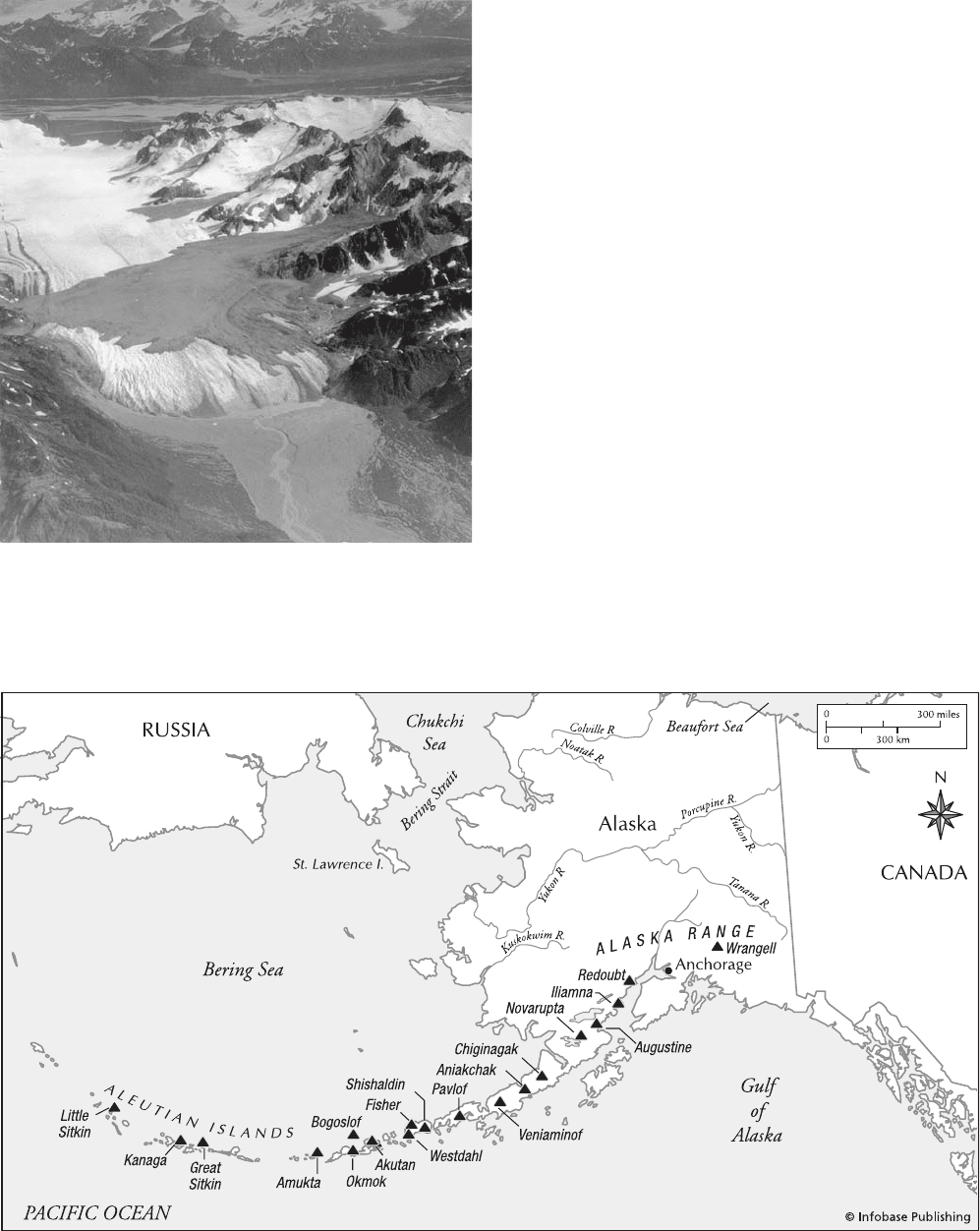
As a result of the 1964 Good Friday earthquake in Alaska, a rockslide-
debris avalanche (dark area) was generated in Shattered Peak and
spilled over Sherman Glacier (white). (Courtesy of the USGS)
Locations of many active volcanoes of the Aleutian arc, Alaska
Alaska 5
by noise from underground. On August 29, 1878, an entire
town on Unalaska Island appears to have been destroyed by
a tsunami and earthquake.
Augustine volcano erupted on October 6, 1883; a very
powerful earthquake and a tsunami occurred in connection
with this eruption. An earthquake in the area of Prince Wil-
liam Sound in May 1896 was so violent that people who
were standing had trouble remaining on their feet. The Yaku-
tat Bay earthquakes of September 3 and 10, 1899, were esti-
mated at Mercalli intensity XI and at Richter magnitudes
8.3 and 8.6, respectively. The epicenter was located near
Cape Yakataga. The first of these earthquakes was felt with
tremendous violence at Cape Yakataga, but the second earth-
quake was the one that caused major changes in topography.
A U.S. Geological Survey expedition to the region six years
after the earthquakes found widespread evidence of topo-
graphic changes. Beaches had been raised, and barnacles and
other aquatic organisms were lifted out of the water. On the
west shore of Disenchantment Bay, an uplift of more than
47 feet (14 m) was measured—approximately the height of
a five-story building. Over a wide area, uplift of 17 feet (6
m) or more was observed. In some areas, depressions of sev-
eral feet occurred. A tsunami thought to have been perhaps
35 feet (11 m) high occurred in Yakutat Bay, and tsunamis
were reported at other locations along the coast of Alaska as
well. There were reports of volcanic eruptions associated with
these earthquakes, but the “eruptions” are presumed to have
been merely large clouds of snow released in slides caused
by the earthquakes. Strong aftershocks occurred over sev-
eral months following these earthquakes. No loss of life was
attributed to the earthquakes because the area was not yet
settled; a small number of Native Americans and prospectors,
however, witnessed the earthquakes firsthand.
On September 21, 1911, an earthquake of Richter mag-
nitude 6.9 on the Kenai Peninsula and Prince William Sound
broke cables, caused great rockslides, and killed large num-
bers of fish; water at Wells Bay was reportedly disturbed
greatly. Cables broke also in another earthquake on Janu-
ary 31, 1912, in the vicinity of Prince William Sound; this
earthquake, which was measured at Richter magnitude 7.25,
appears to have been centered west of Valdez and was felt
in Fairbanks. Very strong shocks occurred at Kanatak, Nush-
agak, and Uyak on June 4–5, 1912, and were felt more than
100 miles (161 km) away from Mount Katmai, although the
earthquakes may have been unaffiliated with the June 6 erup-
tion of Mount Katmai. An earthquake of Richter magnitude
6.4 at Cook Inlet on June 6, 1912, coincided with a bright
display of light from Katmai, and the shock was recorded
at many distant locations, including Ottawa, Ontario, and
Irkutsk in Russia. Very strong earthquakes were reported on
the night of June 6 at Kodiak, and on June 7, a strong earth-
quake struck Kanatak, together with rockslides and a pow-
erful rumbling noise.
An earthquake near Seward on January 3, 1933, mea-
sured at Richter magnitude 6.25, was felt very strongly at
Anchorage, and caused alarm at Seward; the ground cracked
in numerous places in the vicinity of Seward, notably for a
distance of 20 miles (33 km) along a road extending north
from the city. On April 26, 1933, an earthquake northwest
of Anchorage severed telegraph lines and broke plate-glass
windows and was felt also in Fairbanks and in the Aleutian
Islands. Houses were displaced from their foundations at
Old Tyonek. The principal shock measured Richter mag-
nitude 7.0. Old Tyonek experienced further damage several
weeks later when an earthquake of magnitude 6.25 occurred
there on June 13, 1933. The May 14, 1934, earthquake on
Kodiak Island measured magnitude 6.5 and was felt strongly
on Whale and Kodiak Islands; plaster was cracked, and roads
were blocked by landslides. An earthquake of magnitude
6.75 in south central Alaska was strong enough to break
plate glass in Anchorage on August 1, 1934.
Tsunami damage was remarkable in the magnitude 7.4
earthquake of April 1, 1946. Centered about 90 miles (145
km) southeast of Scotch Cap Lighthouse, the earthquake pro-
duced a tsunami that demolished the lighthouse and caused
damage at widely separated locations in and around the
Pacific Basin, along the Pacific coasts of North and South
America, in the Aleutian Islands, and in the Hawaiian
Islands, where 173 persons drowned and property damage
was estimated at $25 million.
The earthquake of March 9, 1957, measured Richter
magnitude 8.3 and was one of the greatest natural calamities
in Alaskan history. The earthquake, which involved hundreds
of aftershocks and affected an area approximately 700 miles
(1,127 km) in length along the southern border of the Aleu-
tian Islands between Amchitka Pass and Unimak Island, was
accompanied by a tsunami 40 feet (12 m) high that struck
the shore at Scotch Cap, and a 26-foot (8-m)-high tsunami
that caused extensive damage at Sand Bay. On the islands of
Kauai and Oahu in Hawaii, the waves destroyed two villages
and caused several million dollars in damage. The tsunami
was 10 feet (3 m) high along the coast of Japan, and a wave
six feet (2 m) high was reported in Chile.
The earthquake of July 9, 1958, is famous for the dra-
matic effect it produced at Lituya Bay, on the Gulf of Alaska
in the southeastern part of the state. A tremendous rockslide
at the head of the bay produced a giant wave (seiche)—more
than 1,700 feet (518 m) high—that swept outward through
the mouth of the bay and is thought to have killed two peo-
ple who were caught in the wave. A fishing boat with two
occupants was carried out of the bay by the wave front and
reportedly cleared the spit at the mouth of the bay by at
least 100 feet (30 m). The wave also wiped the rim of the
bay clean of trees. Otherwise, little damage was reported
from this earthquake, except that underwater communication
cables were broken in the vicinity of Skagway, and Yakutat
experienced damage to bridges, a dock, and oil lines. Great
landslides reportedly occurred in the mountains, and fis-
sures and sand blows were reportedly widespread on the
coastal plain near Yakutat.
The Good Friday earthquake of March 27, 1964, is cov-
ered in detail elsewhere in this volume.
Among the volcanoes of Alaska are Katmai, Augustine,
Pavlof, Redoubt, Iliamna, and Shishaldin. Numerous
calderas, indicative of eruptive activity followed by collapse,
are found at locations such as Aniakchak, Emmons Lake,
Fisher, Little Sitkin, Okmok, Semisopochnoi, Veniami-
nof, and the Wrangell Mountains.
6 Alaska
Alban Hills volcanic structures, Italy The Alban Hills
are located near Rome and are believed to have originated
through a combination of explosive and effusive eruptions. A
period of predominantly effusive eruptive activity is thought
to have produced a stratovolcano that developed a col-
lapsed caldera from which a new central cone arose later.
The record of activity at the Alban Hills in historical times
is uncertain. Eruptions are reported in 114 b.c. and possibly
several centuries earlier, but there is some question whether
these events were volcanic in nature or represent other natu-
ral phenomena such as fires and falls of hail. An ashfall was
reported in nearby Rome in 540 b.c. The volcano Albano is
located in the Alban Hills area, and Lago Albano occupies
an eccentric crater just west of the rim of the inner caldera.
The Via Appia Nuova, Via Appia Antica, and Via Tuscolana
traverse the Alban Hills.
Alcedo volcano, Galápagos Islands, Ecuador Alcedo is
one of several volcanoes on Isabela Island in the Galápagos.
A caldera is present. A lava flow, identified from aerial
photos, appears to have occurred on the southeast side of the
volcano between 1945 and 1961. Radial fissures account
for many of the lava flows on the volcano. Volcanic activity
is suspected (although this has not been proven) as the cause
of an uplift of a short length of shoreline on the west side of
the island, possibly in 1954. A large amount of coral reef was
lifted above sea level, probably at the same time.
Aleppo earthquake, Syria This ancient city in Syria is now
called Halab. It is credited with having experienced one of
the greatest earthquake disasters of all time. On September
8, 1138, a devastating earthquake struck the city. The dam-
age was estimated from historical records to have been XI
on the modified Mercalli scale, with virtually all build-
ings destroyed by the intense ground shaking. The estimated
death toll was a staggering 230,000, though other sources
place it at 100,000. Aleppo was the regional capital at the
time, so the population may have been higher than usual, but
the city of Halab only had a population of about 200,000 in
the last census. In addition, historical records are poor and
incomplete, suggesting that this number could be in error.
Aleppo was struck by another major earthquake on Septem-
ber 5, 1822. Damage from this event was estimated at X on
the modified Mercalli scale; details of the hazards, however,
are again poor. This earthquake is historically well known
because of a report by the American missionary Benjamin
Barker. The report, “Earthquake at Aleppo,” was one of
the first examples of newspaper-style reporting in the United
States. It described well the human suffering and the religious
context but contained no information on hazards. The death
toll from this event was 22,000 people, a more reasonable
number than that for the 1138 event.
Aleutian Islands Alaska, United States The volcanic Aleu-
tian Island chain extends westward from the south shores of
Alaska. The islands are part of a range of volcanic moun-
tains, the Aleutian Range, extending more than 1,600 miles
(2,600 km), from the Alaska Peninsula to a point just east
of the International Date Line. The Aleutian Range contains
dozens of recently active volcanoes, including Augustine,
Bogoslof, Katmai, Novarupta, Pavlof, Redoubt, and
Trident. The tallest volcanoes (up to 11,000 feet [3,400 m])
occur at the northeast end of the range. Summit elevations
generally diminish southwestward along the Aleutians. Sev-
eral kinds of volcanoes occur in the Aleutian Range. Some are
shield volcanoes made up of numerous thin flows of lava.
Other Aleutian volcanoes are composite volcanoes with steep
sides. In some places, these composite cones occur atop older,
shield volcanoes, resulting in a structure much like that of the
Cascade Mountains in the northwest United States and
the Canadian province of British Columbia. Volcanic domes
may also be seen where viscous lava has emerged. A notable
caldera formed from the collapse of Katmai during its 1912
eruption. The Aleutian volcanoes are associated with an off-
shore subduction zone marked by the presence of the Aleu-
tian trench, a deep undersea trough located to the south of
the Aleutians and the Alaska Peninsula. The trench is shal-
lower and eventually vanishes toward the mainland. The pro-
gressive shallowing of the trough is thought to be due to a
buildup of sediment.
The Aleutian Range has been the site of powerful earth-
quakes, such as the Good Friday earthquake of 1964,
which caused great destruction in the vicinity of Anchorage.
Ground subsidence destroyed much of Anchorage’s main
street. Approximately 75 homes in a residential neighborhood
on Turnagain Bluff were wrecked when the land on which
they rested underwent a sudden slump. The earthquake also
demolished the airport control tower and killed the controller
on duty when the structure collapsed. Alaskan earthquakes
have been accompanied by powerful tsunamis on several
occasions in this century. The tsunami that accompanied the
Good Friday earthquake, for example, caused tremendous
damage along the south coast of Alaska, wiped out much of
the state’s commercial fishing fleet, and carried destruction
as far south as Crescent City, California. More than 200
persons were killed as a result of tsunamis originating in Alas-
kan waters between 1946 and the Good Friday earthquake.
In recent years, areas along the Aleutian Range have
emerged as cause for concern as potential sites of major
future earthquakes. One of these so-called gaps is the Com-
mander gap, an area near the west end of the Aleutian chain
where no major earthquake has occurred since the mid-19th
century. The Shumagin gap near the west tip of the Alaska
Peninsula also has been identified as a prospective source of
powerful earthquakes because others have occurred there in
1788 and 1946. (Another strong earthquake in 1903 may
have originated in this area.) The potential for destructive
tsunamis from earthquakes in the Shumagin gap is also con-
siderable. A third “gap” along the southern Alaska coast, the
Yakataga gap, lies near the north tip of the Alaska panhan-
dle. It has been an area of concern for the U.S. Geological
Survey, which expects that strain in the Yakataga gap may
manifest itself in the near future in the form of earthquakes
of magnitude 8.0 or stronger.
Alexandria earthquake, Egypt An earthquake on July 21
in a.d. 365 shook much of the Mediterranean basin and
appears to have caused widespread destruction. Among the
Alexandria 7
most notable casualties of this earthquake was reportedly the
great lighthouse at Alexandria in Egypt. Said to have been
some 600 feet (183 m) high, the lighthouse was reduced to a
ruin that remained in place for the next five centuries. More
than 50,000 people in Alexandria were reportedly killed in
this earthquake, which was accompanied by tsunamis.
Edward Gibbon, in his history The Decline and Fall of the
Roman Empire, describes the effects of this earthquake on
the shores of the Mediterranean:
In the second year of the reign of Valentinian and
Valens, on the morning of the twenty-first day of
July, a violent and destructive earthquake shook the
greatest part of the Roman world. The impression
was communicated to the waters; the shores of the
Mediterranean were left dry by the sudden retreat of
the sea; great quantities of fish were caught with the
hand; large vessels were stranded on the mud; and
a curious spectator [evidently the historian Amma-
nius, whose accuracy Gibbon questions in a footnote
to the work] amused his eye, or rather his fancy, by
contemplating the various appearance of valleys
and mountains which had never, since the forma-
tion of the globe, been exposed to the sun. But the
tide soon returned with the weight of an immense
and irresistible deluge, which was severely felt on
the coasts of Sicily, of Dalmatia, of Greece, and of
Egypt; large boats were transported and lodged on
the roofs of houses, or at the distance of two miles
from the shore; the people, with their habitations,
were swept away by the waters; and the community
of Alexandria annually commemorated the fatal day
on which fifty thousand persons had lost their lives
in the inundation.
The psychological impact of this earthquake on the
Romans appears to have been considerable. Gibbon continues:
This calamity, the report of which was magnified
from one province to another, astonished and terri-
fied the subjects of Rome, and their affrighted imag-
ination enlarged the real extent of a momentary evil.
They recollected the preceding earthquakes, which
had subverted the cities of Palestine and Bithynia;
they considered these alarming strokes as the pre-
lude only of still more dreadful calamities; and their
fearful vanity was disposed to confound the symp-
toms of a declining empire and a sinking world.
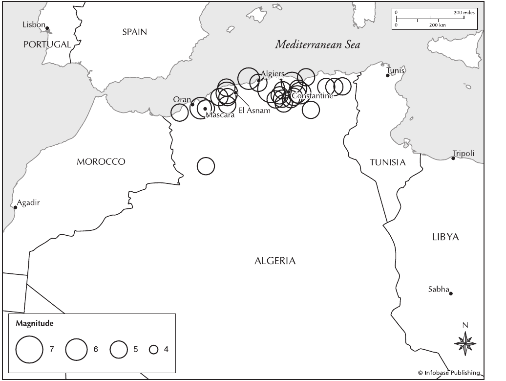
Algeria Algeria lies along the western Mediterranean Sea,
which experiences moderate seismic activity as a result of its
position at the northern margin of the African plate. It is the
grinding between the African and Eurasian crustal plates
that produces the seismicity. The most destructive events have
their sources in the Tellian Atlas Mountains in northern Alge-
ria. This area is dominated by northeast-southwest-oriented
reverse faults, but other areas contain strike-slip and
normal faults as well. The southern region of Algeria contains
the large east-west Sahel Fault, which is also a reverse fault.
The more destructive earthquakes in Algeria include those in
Algiers, 1916 (IX); Oran, 1790 (XI); Mascara, 1889 (IX); El
Asnam, 1980 (Ms=7.3); Constantine, 1985 (Ms=6.0); Tipasa,
1989 (Ms=6.0); Mascara, 1994 (Ms=6.0); and Algiers, 1996
(Ms=5.7) and 2003 (Ms=6.8).
Algiers earthquake, Algeria At 7:44 a.m. local time on
Wednesday May 21, 2003, a major earthquake struck north-
ern Algeria. Its epicenter was located 40 miles (65 km) east-
northeast of Algeria, and the focus was a shallow six miles
(10 km) in depth. The Richter magnitude of the event was
6.8, and damage reached X on the modified Mercalli scale.
More than 1,243 buildings were damaged or destroyed, leav-
ing some 150,000 homeless. A tsunami with a maximum
run-up height of 6.5 feet (2 m) was generated in the Med-
iterranean Sea and damaged boats along the coast. Total
damage was estimated at $100 million. The death toll for
this event was 2,266, and there were 10,261 people injured.
Alkalic basalt basalt (lava) that is unusually rich in
alkali elements (K, Na, etc.). These lavas are common in con-
tinental rifting but only in the early stages or at the end of
a volcanic period. They occur in such hot spots as Hawaii
under the same conditions. There is no visual way to tell an
Alkalic basalt from a regular basalt; chemical analysis is nec-
essary.
Allahbund (Gujarat) earthquake, India The Rann of
Kutchh was shaken by a violent earthquake on June 16,
1819, at about 7:00 p.m. A 55-mile (90-km) stretch of land
was elevated by up to 14.3 feet (4.3 m) during this event and
named the Allah Bund which translates to “mound of God.”
Trenching of the feature indicated that it was a fold rather
than a fault, and it had been elevated at least twice prior to
the 1819 earthquake. The fault that generated the earthquake
was therefore a blind fault and appeared to have been a
northwest-oriented reverse fault. To the south of this
area, subsidence in the range of 16.5 to 20 feet (5 to 6 m)
flooded the Fort of Sindri. The Richter magnitude of this
earthquake was estimated to have been between 7.5 and 8.3,
but the lower number is more probable. Shaking appeared to
have lasted almost two minutes.
Records of casualties from the earthquake are incon-
sistent, but there were at least 1,550 people killed. The
majority of the damage occurred within a 49.7-mile (80-
km) radius of the epicenter, although excessive shaking
was reported from more than 186.4 miles (300 km) away.
liquefaction was one of the main surface effects. Many
buildings tilted and fell over, and mud volcanoes were 12 to
20 feet (3.7 to 6 m) in diameter and active for two to three
days. The tributaries of the Indus River were also strongly
affected. Flow stopped for three days in the Fullalee River,
and the Nara River was blocked by a landslide, forming a
large pool, while the downstream portion dried up. after-
shocks continued for several months, with the strongest on
June 17 and July 15.
Aluto See Asawa.
8 Algeria
Amatitlán caldera, Guatemala The Amatitlán caldera is
located several miles south of Guatemala City and includes
the volcano Pacaya, which has a long history of unrest
within historical times.
Ambrim volcano, Vanuatu Situated at the intersection of
the Vanuatu archipelago and the D’Entrecasteaux fracture
zone near the Loyalty Islands, the volcanic island Ambrim
has exhibited numerous explosive eruptions and lava flows
during the past two centuries. Roughly triangular in shape,
Ambrim is approximately 30 miles (48 km) long and 20
miles (32 km) wide at its broadest point. A large caldera
occupies the summit. Two cones inside this caldera, Mount
Marum and Mount Benbow, show nearly constant activity.
Several small volcanoes (Rahoum, Tower Peak, and Tuvio)
also are found on the island. The historical record of activity
on Ambrim is brief but colorful. It formed about a.d. 50 and
has had 48 eruptions since then. Emissions resembling smoke
were reported in 1774, and in 1888 a flow of lava was
observed from a rift on the southeastern side of the island.
Large numbers of earthquakes characterized an eruption in
1894. Dates of eruptive activity between 1912 and 1915 are
not entirely certain, but Mount Benbow and various other
sites on the island appear to have shown eruptive activity.
Strong earthquakes accompanied eruptions in 1913 along
fissure lines lying east to west across the island, and reports
mention a large eruption cloud and emissions of flames. A
hospital was destroyed in this set of eruptions. Strong earth-
quakes accompanied another eruption in late March 1937,
and marked seismic activity was noted before the lengthy
eruption of 1950 through 1954. An explosion in 1972 did not
show any precursor earthquake activity. Ambrim remained
in nearly continuous eruption between 1964 and 1980. Acid
rain generated by emissions of sulfur dioxide harmed crops
in February 1979. Eruptions are thought to have occurred
around the end of 1985 and in early 1986. In February 1988,
Map of Algeria and neighboring countries showing tectonic boundaries, the locations and intensities of recent earthquakes, and several of the cities that
experienced serious historical earthquakes
Ambrim 9
the crew of an aircraft flying near the island observed an
eruption from Mount Benbow.
amplification Amplification is any process that increases
the amplitude of seismic waves. Amplification may be the
enhancement of the strength of a signal through electronic
means, so that even small earthquakes can be analyzed. The
seismic energy may also be increased locally by focusing it
through geologic means. This focusing is typically through
the geometry of the structure of a basin, the topography of a
basin, or the sediment (stratigraphic) velocity structure. The
result is great damage in specific areas distant from the earth-
quake epicenter and with much less damage in all surround-
ing areas.
amplitude Physical distances of all waves, whether ocean,
radio, or seismic (earthquake), define certain quantities. One-
half height of a wave from crest to trough is the amplitude.
Amukta volcano, Alaska, United States It is a poorly
known, seismically unmonitored, and uninhabited island
stratovolcano. It has erupted at least five times since its
discovery in 1760. Its last major eruption was in 1987, but it
underwent a minor eruption in September 1996.
amygdaloidal vesicles in volcanic rocks are holes that
look like worms made them. Mineral-bearing waters flow
through these holes and deposit minerals in them. When
the holes are filled with mineral, they are called amygdules.
Amygdaloidal refers to a rock that contains amygdules. Min-
erals common to amygdules include calcite, quartz (includ-
ing amethyst), and prehnite.
Anak Krakatoa See Krakatoa.
Anatolia earthquake, Turkey On October 16, 1883, an
earthquake at Anatolia in Asia Minor, now part of Turkey,
killed perhaps 1,000 people and left some 20,000 homeless.
Great fissures are said to have opened and shut in the earth
during this earthquake. Starvation and cold temperatures
reportedly killed several hundred more residents of Anatolia
before assistance could arrive.
Ancash earthquake, Peru On November 10, 1946, at
12:40 p.m., a devastating earthquake struck the mountain-
ous region of Peru and, in particular, the villages of Ancash
and Quiches. The quake had a Richter magnitude of 7.4
and was felt 400 miles (680 km) to the north in Guayaquil,
Ecuador, and 245 miles (410 km) to the south in Lima, Peru.
This means that it affected an area of about 175,000 square
miles (450,000 km
2
). Although the focus of this earthquake
was 18–24 miles (30–40 km) deep, making it subduction
zone–related, there was significant surface rupturing, leav-
ing a scarp along the Quiches fault for some three miles (5
km) in length. Whether this was a related rupture through an
aftershock or a foreshock is not clear.
An estimated 1,400 people lost their lives in the Ancash
earthquake. The reason for the relatively high death toll in
such a sparsely populated area was the mass movements. The
earthquake shook loose multiple landslides on many scales,
including several avalanches, rockfalls, and rockslides.
These mass movements slid down the steep slopes, destroying
the villages in the valleys below.
Andaman Islands earthquake, India A devastating earth-
quake struck the Andaman Islands India, on June 26, 1941.
It had a Richter magnitude of 7.7, with a duration of four
minutes, making it one of the strongest in the area. The
focus of the earthquake was 33 miles (55 km) deep, mak-
ing it subduction zone–related. Tremors were felt strongly
in the area around Calcutta, India, but also as far away as
Sri Lanka. There were many aftershocks, including two
of magnitude 6.0 within 24 hours of the main shock and
14 of magnitude 6.0 through January 1942. A tsunami was
generated in the Bay of Bengal by this event. The height of
the waves was less than 6.6 feet (2 m) in all cases, but they
nonetheless devastated the Indian coast, causing most of the
loss of life. The death toll for the entire event was in excess
of 5,000 people, but records are poor, and the numbers could
be much higher.
andesite One of the most common volcanic rocks, andesite
is widely distributed around the Pacific basin (the “Ring of
Fire”), where chains of andesitic volcanoes form the “andes-
ite line” that has been used to mark the boundary of the
Pacific basin. Andesitic volcanic rocks also are found in other
regions of the world, including Europe’s Carpathian Moun-
tains, the Himalaya Mountains, the Zagros Mountains, some
of the active volcanoes in the Mediterranean, the Carib-
bean Islands, and the South Sandwich Islands. Andesite varies
in composition but is generally characterized as a gray rock
that is lighter in color than basalt but most commonly darker
than rhyolite. It is also intermediate between basalt and
rhyolite in terms of silica content. The composition of andes-
ite indicates that it derives its chemical makeup from condi-
tions in the mantle below the continents. Experimental studies
reveal that the melting of the subducting wet ocean crust or
melting of mantle that has been injected with water from the
subducting oceanic crust can account for the composition.
However, in cases of magmatic arcs where magma must
pass through thick continental crust, andesite contains com-
monly assimilated components of crustal rock as it rises to
the surface. The characteristics of andesite output vary greatly
from one volcano or cluster of volcanoes to another. In some
areas, a group of volcanoes may emit andesite of remarkably
consistent composition, whereas a single volcano elsewhere
may put out a variety of types. Many volcanoes release two
main types of rocks, a principal andesitic series and another
group made up largely of basalt with either rhyolite or dacite
mixed in. Andesite volcanoes also emit large quantities of
ash and other ejecta. Composite andesitic volcanoes, widely
found around the Pacific Ocean basin, are composed of
tephra and flows of andesite and rhyolite and commonly fea-
ture calderas formed by explosive eruption and the collapse
of a cone into a depleted magma chamber beneath the moun-
tain, as in the case of Crater Lake in Oregon.
andesite line See andesite.
10 amplification
Andes Mountains The Andes mountain range is part
of the Andean cordillera, which extends along the western
edge of South America. The Andes are formed by an ongo-
ing collision between the South America plate and primarily
the Nazca crustal plate (Antarctic and Cocos as well)
that underlies the southeast Pacific Ocean. This subduc-
tion zone is considered the model for convergent plate
boundary in which oceanic crust is subducted beneath con-
tinental crust. All other such geometries are referred to as an
Andean Margin. The Andes Mountains form a magmatic
arc with extensive plutonic and volcanic activity. Volcanic
and hydrothermal activity along the Andean cordillera
has generated hot springs and numerous commercially viable
deposits of ores of various metals, among them copper, silver,
and gold. tsunami activity also has been associated with the
numerous and regular strong earthquakes along the Andean
cordillera. The strongest recorded earthquake in the world
occurred in Chile in 1960.
A curious magnetic anomaly has been reported along the
Andean cordillera. A reversal of change in the vertical geo-
magnetic field has been accompanied by an intensified change
in the horizontal magnetic field. This pattern indicates the
existence of internal induction currents at a depth of perhaps
40 miles (70 km), along a high-conductivity zone beneath the
mountains.
Earthquakes occur frequently in and near the Andean
cordillera. An earthquake in Chile in 1822, for example,
reportedly killed some 10,000 persons and raised the shore-
line by several feet. Along the Pacific shore, earthquakes are
sometimes accompanied by tsunamis. The volcanoes and
volcanic deposits in the Andes include Cerro Rico, Copa-
hué, Cordillera Nevada, Diamante, Nevado del Ruiz,
Nevados de Chilian, and Puracé.
See also Bolivia; Concepción; Peru; plate tectonics.
Andijan earthquake, Turkestan (Uzbekistan) An earth-
quake of Richter magnitude 6.4 struck the town of Andi-
jan in Turkestan (now Uzbekistan) on December 16, 1902,
at 5:07 a.m. The focus of the earthquake was at a depth
of 5.5 miles (9 km). The damage was extreme, and freez-
ing temperatures and continuing aftershocks exacerbated
the disaster. The death toll was at least 4,500, but some
reports placed it as high as 10,000 people. Some 15,000
houses were destroyed, and the cost of the damage was
upward of $6 million.
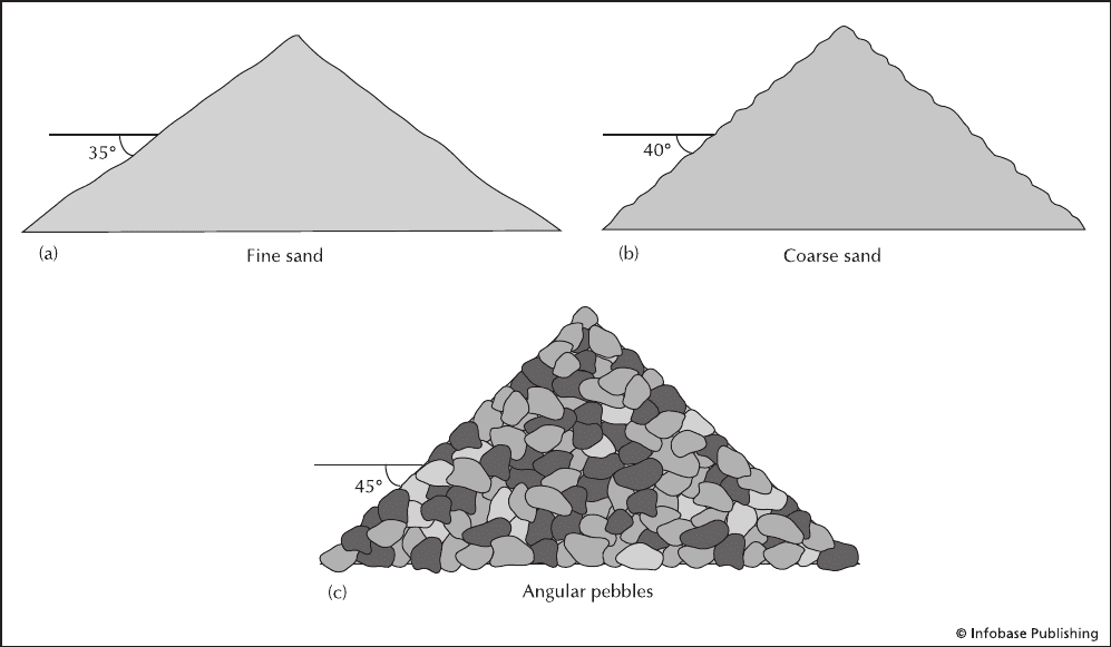
angle of repose The angle of repose is the maximum angle
that a slope of a certain material can exist at under a certain
set of conditions before it fails. If a person slowly dumps a
bucket of dry sand on the floor, it will form a cone-shaped
pile with a fixed angle of the slopes regardless of where it
is measured. To make the pile higher, the person adds more
sand, but the pile does not grow straight up. Instead, most of
the sand slides down the slopes (slope failure), and the pile
grows wider as it gets higher. The angle of the slopes of the
bigger pile will be exactly the same as that for the smaller
Piles of various particle types (sediment) showing their angle of repose, the maximum slope angle that they can attain before sloughing off.
angle of repose 11