Wai-Fah Chen.The Civil Engineering Handbook
Подождите немного. Документ загружается.


Plane Surveying 54-35
points will need to be determined. It is the responsibility of the field engineer to determine the most
efficient method of field measurement to collect the data.
However, it should be mentioned that sometimes volumes can be determined using no field measure-
ments at all. In some situations the contractor may be paid for the number of truckloads removed.
Keeping track of the number of trucks leaving the site is all that may be necessary. However, this isn’t a
particularly accurate method since the soil that is removed expands or swells and takes up a larger amount
of space than the undisturbed soil. Depending on how the project is bid, it is sometimes accurate enough.
Field Measurements for Volume Computations
Measurements for volume are nothing more than applying basic distance and elevation measurements
to determine the locations and elevations of points where the volume is to be determined. It usually is
not practical to take the time to collect data everywhere there is a slight change in elevation. Therefore,
it must be understood that volume calculations do not give exact answers. Typically, approximations
must be made and averages determined. The field engineer will analyze the data and make decisions that
result in the best estimate of the volume.
Area
The key to volume calculation is the determination of area. Most volume calculation formulas contain
within them the formula for an area, which is simply multiplied by the height to determine the volume.
For instance, the area of a circle is pi times the radius squared. The volume of a cylinder is the area of
the circle times the height of the cylinder. If an area can be determined, it is generally easy to determine
the volume.
Counting Squares
Approximation is possible by plotting the figure to scale on cross-sectional paper and counting the
squares. Each square represents x number of square feet. Incomplete squares along the edges of the cross
section are visually combined and averaged.
TA BLE 54.8 Ve rtical Curve Elevations
Station X sta (r/2)X
2
g
1
X
Elevation
Y ft
PVC 150 + 40.00 Y
0
622.45
0.6000 0.21 – 1.80
151 + 00.00 620.86
1.6000 1.50 – 4.80
152 + 00.00 619.15
2.6000 3.98 – 7.80
153 + 00.00 618.83
3.6000 7.62 –
10.80
154 + 00.00 619.27
4.6000 12.45 –
13.80
155 + 00.00 621.10
5.6000 18.45 –
16.80
156 + 00.00 624.10
6.6000 25.62 –
19.80
157 + 00.00 628.27
7.6000 33.98 –
22.80
158 + 00.00 633.63
8.5000 42.50 – 25.50
PVT 158 + 90.00 639.45
© 2003 by CRC Press LLC

54-36 The Civil Engineering Handbook, Second Edition
Planimeter
The electromechanical digital planimeter is a quick method of determining the area of irregularly shaped
figures. The irregular shape is drawn to scale and the planimeter is used to trace the outline of the shape.
Inputting a scale factor into the planimeter results in a digital readout of the area.
Geometric Formula
Although a shape at first may seem irregular, it is often possible to break it into smaller regular shapes
such as squares, rectangles, triangles, trapezoids, etc., that will allow the use of standard geometric
formulas to determine the area. This method may be cumbersome because of all the shapes that may
need to be calculated.
Cross-Section Coordinates
If cross-sectional field data are available, use of this data is the recommended method of calculating
volume. Once understood, this process is fast and the most accurate way of determining area. Cross
section data collected on a project represent elevation and location information for points on the ground.
These points can be used as coordinates to determine area.
Volume Computations — Road Construction
In road construction the shape of the ground must be changed to remove the ups and downs of the hills
and valleys for the planned roadway. Often mountains of dirt must be moved to create a gentle grade
for the roadway. Payment for the removal and placement of dirt is typically on a unit cost basis. That is,
the contractor will be paid per cubic yard of soil and will receive a separate price per cubic yard of rock.
It can be seen that accurate determination of the volume moved is critical to the owner and to the
contractor. Each wants an accurate volume so payment for the work is correct.
For road projects, cross sections of the ground elevations are measured at the beginning of the project,
during the project, and at the end of the project. Comparisons between final cross sections and original
cross sections are used to determine the volume moved. Areas of the cross sections are most easily
determined by using the elevations of the points and their locations from the centerline (coordinates).
The average end area method uses the end areas of adjacent stations along a route and averages them.
Refer to Fig. 54.32. This average is then multiplied by the distance between the two end areas to obtain
the volume between them. In formula form the process is as follows:
FIGURE 54.32 Average end area method.
VOLUME =
L
27
AREA 1 + AREA 2
2
20 + 0
AREA 2
21 + 0
AREA 1
© 2003 by CRC Press LLC
Plane Surveying 54-37
where L represents the distance between the cross-sectional end areas being used in the formula, and
27 represents the number of cubic feet in 1 cubic yard. Dividing cubic feet by 27 converts to cubic yards.
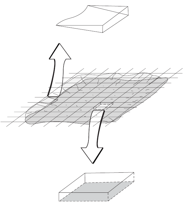
Volume Computations — Building Excavation
A method known as borrow-pit leveling can be used effectively to determine volume on building projects.
A grid is established by the field engineer and elevations on the grid points are determined both before
the excavation begins and when the work is complete.
The borrow-pit method uses a grid and the average depth of the excavation to determine the volume.
Before the excavating begins the field engineer creates a grid over the entire area where the excavation
is to occur. Elevation data are collected at each of the grid points and recorded for future reference. At
any time during the excavating, the field engineer can reestablish the grid and determine new elevations
for each of the field points. Using the average height formula shown below, the volume of soil removed
from each grid area can be determined. Refer to Fig. 54.33. The smaller the grid interval, the more
accurate the volume.
FIGURE 54.33 Borrow-pit method.
Volume
L
27
-----
Area 1 Area 2+
2
-------------------------------------
˯
ʈ
=
96.2
30
93.2
83.1
50
95.0
40
96.7
87.2
97.2
50
98.3
85.1
50
93.5
86.2
84.3
91.2
88.4
50 × 50 GRID
© 2003 by CRC Press LLC
54-38 The Civil Engineering Handbook, Second Edition
Summary
Only two general methods of calculating volumes have been presented here. There are many others that
are very specific for the particular situation. For example, when determining volumes along a roadway,
there is a constant transition from cut to fill to cut to fill, etc. To more accurately compute the volume,
a prismoidal formula is used. The field engineer should check with textbooks that discuss in detail route
surveying and earthwork for additional information.
Defining Terms
Accuracy — Refers to the degree of perfection obtained in measurements. It is a measure of the closeness
to the true value.
Accuracy (first-order) — The highest accuracy required for engineering projects such as dams, tunnels,
and high-speed rail system.
Accuracy (second-order) — The accuracy required for large engineering projects such as highways,
interchanges, and short tunnels.
Accuracy (third-order) — The accuracy required for small engineering projects and topographic map-
ping control.
Accuracy ratio — The ratio of error of closure to the distance measured for one or a series of measurements.
Axis of level bubble — The line tangent to the top inner surface of a spirit level at the center of its
graduated scale, and in the plane of the tube and its center of curvature.
Calibration — The process of comparing an instrument or chain with a standard.
Closure — The amount by which a value of a quantity obtained by surveying fails to agree with a value
(of the same quantity) determined. It is also called misclosure or error of closure.
Datum — A reference elevation such as mean sea level or, in the case of some construction projects, a
benchmark with elevation 100.00.
Horizontal axis — The axis about which the telescope rotates vertically.
Least squares — A mathematical method for the adjustment of observations based on the theory of
probability.
Line of sight — The line extending from an instrument along which distinct objects can be seen. The
straight line between two points.
Mean sea level — The average height of the surface of the sea measured over the complete cycle of high
and low tides (a period of 18.6 years).
Monument — A physical structure that marks the location of a survey point.
Nadir — The point directly under the observer. The direction that a plumb bob points.
Precision — The closeness of one measurement to another. The degree of refinement in the measuring
process. The repeatability of the measuring operation.
Random errors — Errors that are accidental in nature and always exist in all measurements. They follow
the laws of probability and are equally high or low.
Refraction — The bending of light rays as they pass through the atmosphere.
Systematic error — Those errors that occur in the same magnitude and the same sign for each mea-
surement of a distance, angle, or elevation. Can be eliminated by mechanical operation of the
instrument or by mathematical formula.
Ve rtical — The direction in which gravity acts.
Zenith — The point directly above a given point on earth.
References
Anderson, J.M., and Mikhail, E.M. 1985. Introduction of Surveying. McGraw-Hill, New York.
Crawford, W.G. 1994. Construction Surveying and Layout, P. O.B. Publishing, Canton, MI.
Davis, R.E. et al. 1981. Surveying: Theory and Practice, 6th ed. McGraw-Hill, New York.
© 2003 by CRC Press LLC
Plane Surveying 54-39
Federal Geodetic Control Committee. 1984. Standards and Specifications for Geodetic Control Networks.
National Geodetic Information Branch, NOAA, Silver Springs, MD.
Fronczek, C.J. 1980. NOAA Technical Memorandum NOS NGS-10. National Geodetic Information
Branch, NOAA, Silver Springs, MD.
National Geodetic Survey. 1986. Geodetic Glossary. National Geodetic Information Branch, NOAA, Silver
Springs, MD.
Professional Surveyor. American Surveyors Publishing Company, Suite 501, 2300 Ninth Street South,
Arlington, VA.
Point of Beginning. Business News Publishing Company, Troy, MI.
Wolf, P.R., and Brinker, R.C. 1994. Elementary Surveying, 9th ed. HarperCollins, New York.
Further Information
The material here is intended only as an overview of plane surveying. There are many textbooks dedicated
completely to the various aspects of surveying. The authors recommend the following books. For a more
complete presentation of surveying theory, consult Elementary Surveying, 9th ed., by Wolf and Brinker,
HarperCollins, 1992; or Surveying: Theory and Practice, 6th ed., by Davis et al., McGraw-Hill, 1981. For
illustrated step-by-step descriptions of performing field work, consult Construction Surveying and Layout,
by Crawford, P.O.B. Publishing, 1994.
To obtain detailed information on the capabilities of various instruments and software, P.O.B. Pub-
lishing prepares the trade magazine P. O.B., and American Surveyors Publishing Company prepares the
trade magazine Professional Surveyor. Each of these publications conducts annual reviews of theodolites,
total stations, EDMIs, data collectors, GPSs, and software. These listings allow the reader to keep up-to-
date and compare “apples to apples” when analyzing equipment.
Survey control information, software, and many useful technical publications are available from the
National Geodetic Survey (NGS). The address is
National Geodetic Survey Division
National Geodetic Information Branch, N/CG17
1315 East-West Highway, Room 9218
Silver Spring, MD 20910-3282
© 2003 by CRC Press LLC

© 2003 by CRC Press LLC
55
Geodesy
55.1 Introduction
55.2 Coordinate Representations
Two-Dimensional • Three-Dimensional • Coordinate
Tr ansformations • Curvilinear Coordinates and
Tr ansformations
55.3 Coordinate Frames Used in Geodesy and Some
Additional Relationship
Earth-Fixed • Inertial and Quasi-Inertial • Relation between
Earth-Fixed and Inertial
55.4 Mapping
Two Worlds • Conformal Mapping Using Cartesian Differential
Coordinates • Conformal Mapping Using Polar Differential
Coordinates • Coordinate Transformations and Conformal
Mapping
55.5 Basic Concepts in Mechanics
Equations of Motion of a Point Mass in an Inertial Frame •
Potential
55.6 Satellite Surveying
Numerical Solution of Three Second-Order Differential
Equations • Analytical Solution of Three Second-Order
Differential Equations • Orbit of a Satellite in a Noncentral
Force Field • The Global Positioning System
55.7 Gravity Field and Related Issues
One-Dimensional Positioning: Heights and Vertical Control •
Two-Dimensional Positioning: East–North and Horizontal
Control • Three-Dimensional Positioning: Geocentric
Positions and Full
Three-dimensional Control
55.8 Reference Systems and Datum Transformations
Geodetic Reference Frames • Geodetic Reference System 1967 •
Geodetic Reference System 1980 • 1983 Best Values • 1987 Best
Va lues and Secular Changes • World Geodetic System 1984 •
IERS Standards 1992 • Datum and Reference Frame
Tr ansformations • Textbooks and Reference Books • Journals
and Organizations
55.1 Introduction
This chapter covers the basic mathematical and physical aspects of modeling the size and shape of the
earth and its gravity field. Terrestrial and space geodetic measurement techniques are reviewed. Extra
attention is paid to the relatively new technique of satellite surveying using the Global Positioning System
(GPS). GPS surveying has not only revolutionized the art of navigation, but also brought about an
efficient positioning technique for a variety of users, engineers not the least. It is safe to say that any
B.H.W. van Gelder
Purdue University

55
-2
The Civil Engineering Handbook, Second Edition
geometry-based data collecting scheme profits in some sense from the full constellation of 24 GPS
satellites. Except for the obvious applications in geodesy, surveying, and photogrammetry, the use of GPS
is applied in civil engineering areas such as transportation (truck and emergency vehicle monitoring,
intelligent vehicle and highway systems, etc.) and structures (monitoring of deformation of such struc-
tures as water dams). Even in areas such as forestry and agriculture (crop yield management), GPS
provides the geometric backbone to the (geographic) information systems.
Modern geodetic measurement techniques, using signals from satellites orbiting the earth, necessitate
a new look at the science of geodesy. Classical measurement techniques divided the theoretical problem
of mapping small or large parts of the earth into a horizontal issue and a vertical issue. Three-dimensional
measurement techniques “solve” the geodetic problem at once. However, careful interpretation of these
three-dimensional results is still warranted, probably even more so than before. This chapter will center
around this three-dimensional approach. Less attention has been devoted to classical issues such as the
computation of a geodesic on an ellipsoid of revolution. Although this issue still has some importance,
the reader is referred to the textbooks listed at the end of this chapter.
More than in classical texts, three-dimensional polar (spherical) coordinate representations are used,
because the fundamental issues pertaining to various geodetic models are easier to illustrate by spherical
coordinates than by ellipsoidal coordinates. Moreover, the increased influence of the satellite techniques
in everyday surveying revives the use of three-dimensional polar coordinate representations, because the
three-dimensional location of a point is equally accurately represented by Cartesian, spherical, or ellip-
soidal coordinates.
Throughout this chapter all coordinate frames are treated as right-handed orthogonal trihedrals.
Because this also applies to curvilinear coordinates, the well-known geographic coordinates of latitude
and longitude are presented in the following order:
1. Longitude (positive in east direction),
l
2. Latitude,
y
or
f
3. Height,
h
In short, {
l
,
y
,
h
} or {
l
,
f
,
h
}. Local Cartesian and curvilinear coordinates are treated in a similar fashion.
55.2 Coordinate Representations
For a detailed discussion on coordinate frames and transformations, the reader is referred to Chapter 53.
Two-Dimensional
In surveying and mapping, two-dimensional frames are widely used. The different representations are
all dependent, because only two numbers suffice to define the location of a point in 2-space. Cartesian
frames consist of two often perpendicular reference axes, denoted as
x
and
y
, or
e
(easting) and
n
(northing). Points in two-dimensional frames are equally well represented by polar coordinates
r
(distance
from an origin) and
a
(polar angle, counted positive counterclockwise from a reference axis).
We have
(55.1)
The polar coordinates {
r
,
a
} are expressed in terms of the Cartesian counterparts by
(55.2)
xr
yr
=
=
cos
sin
a
a
rxy
yx
=+
=
()
22
a arctan
© 2003 by CRC Press LLC
Geodesy
55
-3
Three-Dimensional
Three-Dimensional Cartesian Coordinates
There are various ways to represent points in a three-dimensional space. One of the most well known is
the representation by the so-called Cartesian coordinates
x
,
y
,
z
; we represent the position of a point
A
through three distances
x
,
y
,
z
(coordinates) to three perpendicular planes, the
yz
-,
xz
-,
xy
-planes,
respectively. The intersecting lines between the three planes are the perpendicular coordinate axes. The
position of point
A
is thought to be represented by the vector x with elements {
x
,
y
,
z
}:
(55.3)
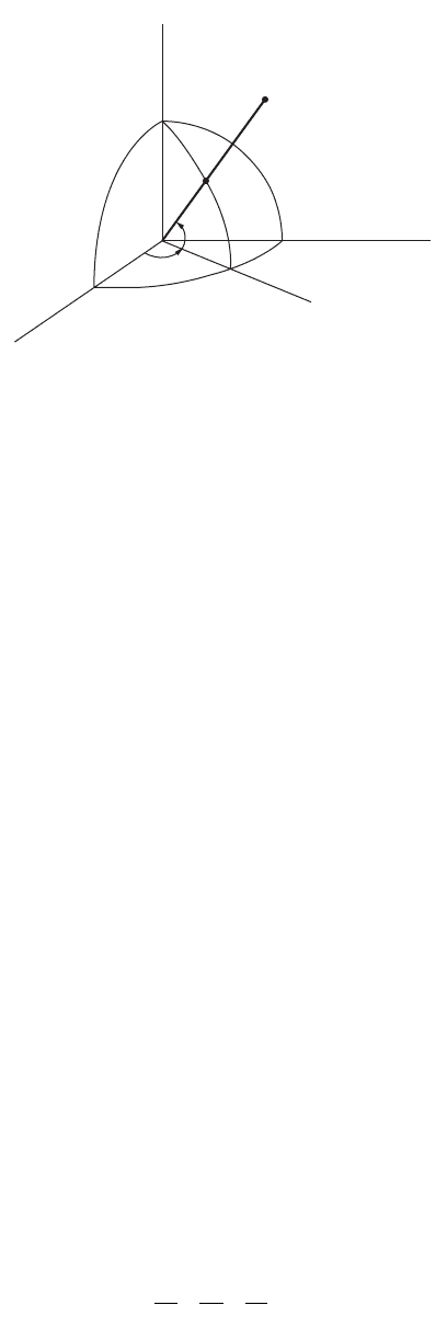
Three-Dimensional Polar Coordinates: Spherical
We may want to represent the position of these points with respect to a sphere with radius
R
. We make
use of so-called spherical coordinates. The earth’s radius is about
R
= 6371.0 km.
The sphere is intersected by two perpendicular planes, both of which pass through the center
O
of the
sphere: a reference
equatorial plane
(perpendicular to the rotation axis) and a reference
meridian plane
(through the rotation axis). The angle between the vector and the reference equatorial plane is called
latitude,
y
. The angle between the reference meridian plane (through Greenwich) and the local meridian
plane (through
A
) is called
longitude,
l
(positive east). The distance to the surface of the sphere we call
height, h
. Consequently, the position of a point
A
is represented by {
l
,
y
,
h
} or {
l
,
y
,
r
} or {
l
,
y
,
R
+
h
};
see Fig. 55.1.
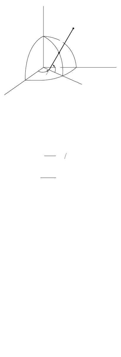
Three-Dimensional Polar Coordinates: Ellipsoidal
The earth is flattened at the poles, and the average ocean surface has about the shape of an ellipsoid. For
this reason, ellipsoidal coordinates are more often used in geodesy than spherical coordinates. We express
the coordinates with respect to an ellipsoid of revolution with an equatorial semimajor axis
a
and a polar
semiminor axis
b
. The semimajor axis thus represents the equatorial radius, and
b
is the distance between
the ellipsoidal origin and the poles. The equation of such an ellipsoid of revolution is
(55.4)
FIGURE 55.1
(Geographic) spherical coordinates: longitude
l
, latitude
y
, and height
h
.
A
z
y
x
h
s
ψ
λ
x =
Ê
Ë
Á
Á
Á
Á
ˆ
¯
˜
˜
˜
˜
x
y
z
x
a
y
a
z
b
2
2
2
2
2
2
1++=
© 2003 by CRC Press LLC
55
-4
The Civil Engineering Handbook, Second Edition
For the earth we have a semimajor axis
a
= 6378.137 km and a semiminor axis
b
= 6356.752 km. This
means that the poles are about 21.4 km closer to the center of the earth than the equator.
The flattening of the earth is expressed by
f
and the (first) eccentricity by
e
:
(55.5)
(55.6)
See also Fig. 55.2.
Coordinate Transformations
We have to distinguish between two classes of transformations:
•Transformations between dissimilar coordinate representations. An example would be the trans-
formation between Cartesian coordinates and curvilinear coordinates, such as the ellipsoidal
(geodetic) coordinates.
•Transformations between similar coordinate frames. An example is the relation between geocentric
Cartesian coordinates and topocentric Cartesian coordinates.
The latter group is to be discussed subsequently in this section, after we consider transformations
between dissimilar coordinate representations.
Transformations of Different Kind
If the
xy
-plane coincides with the equator plane and the xz-plane with the reference meridian plane, then
we have the following:
From spherical to Cartesian:
(55.7)
FIGURE 55.2 (Geodetic) ellipsoidal coordinates: longitude l, latitude f, and height h.
A
y
x
z
j
l
h
e
f
ab
a
=
-
ª
()
1 298 257.
e
ab
a
2
22
2
0 00669438=
-
ª
()
.
x
y
z
Rh
Ê
Ë
Á
Á
Á
Á
ˆ
¯
˜
˜
˜
˜
=+
()
Ê
Ë
Á
Á
Á
Á
ˆ
¯
˜
˜
˜
˜
cos cos
cos sin
sin
yl
yl
y
© 2003 by CRC Press LLC

Geodesy 55-5
From Cartesian to spherical:
(55.8)
From ellipsoidal to Cartesian:
(55.9)
with
(55.10)
and
(55.11)
In these equations the variable N has a distinct geometric significance: it is the radius of curvature in
the prime vertical plane. This plane goes through the local normal and is perpendicular to the meridian
plane. In other words, N describes the curvature of the curve obtained through the intersection of the
prime vertical plane and the ellipsoid. The curve formed through the intersection of the meridian plane
and the ellipsoid is given by M; see Fig. 55.3.
The varying radius of curvature M of the elliptic meridian is given by
(55.12)
FIGURE 55.3 Meridian plane through point A.
l
y
h
yx
zx y
xyzR
Ê
Ë
Á
Á
Á
Á
Á
Á
ˆ
¯
˜
˜
˜
˜
˜
˜
=
=
=
()
+
()
++-
Ê
Ë
Á
Á
Á
Á
Á
Á
Á
ˆ
¯
˜
˜
˜
˜
˜
˜
˜
arctan
arctan
22
222
x
y
z
Nh
Nh
Neh
Ê
Ë
Á
Á
Á
Á
ˆ
¯
˜
˜
˜
˜
=
+
[]
+
[]
-
()
+
[]
Ê
Ë
Á
Á
Á
Á
ˆ
¯
˜
˜
˜
˜
cos cos
cos sin
sin
fl
fl
f1
2
N
a
W
=
We=-1
22
sin f
M
ae
W
=
-
()
1
2
3
N
A
A′′
h
A′
xy-plane
z
CoM
j
© 2003 by CRC Press LLC