Wai-Fah Chen.The Civil Engineering Handbook
Подождите немного. Документ загружается.

Plane Surveying
54
-5
where
a
=
vertical
angle of the tape and
z
=
zenith
angle of the tape, or by
where
h
= difference in elevation between the ends of the tape. If all tape corrections are carefully applied,
accuracies of 1 part in 10,000 to 1 part in 20,000 can be obtained.
Electronic Distance Measurement
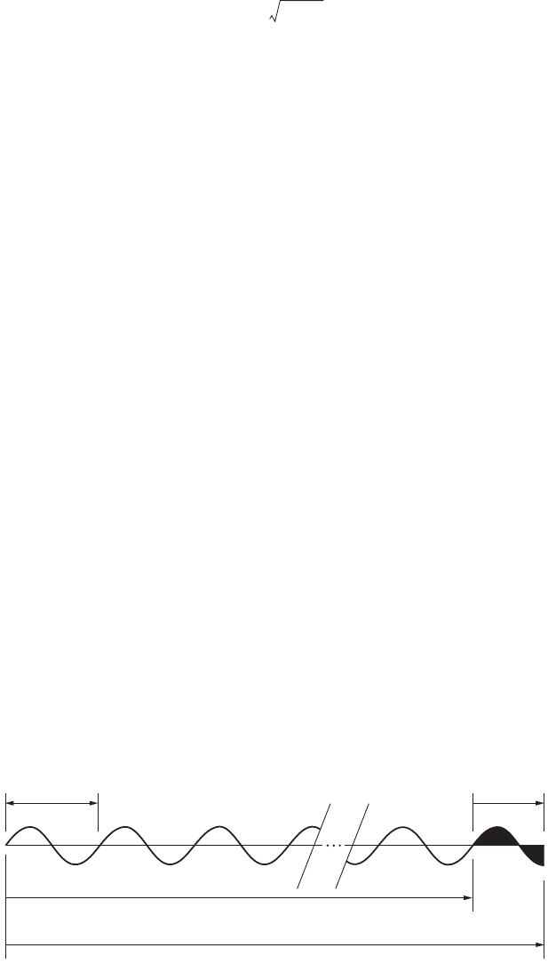
Distance can be measured electronically if the velocity and travel time of electromagnetic energy prop-
agated along a survey line are determined. Terrestrial electronic distance measurement instruments
(EDMIs) measure the travel time by comparing the phase of the outgoing measurement signal to the
phase of the signal returning from the remote end of the line. The phase difference is thus a function of
the double path travel of the measurement signal. The distance is given by
where
V
= the velocity of electromagnetic energy in the atmosphere and
T
= the double path travel time
determined using the phase difference.
If
Df
is the phase difference observed for the fine or shortest wavelength measurement signal, then
the total travel time is found from the equation
where
f
= the frequency of the measurement signal and
k
= the integer number of full cycles in the double
path distance. The integer
k
is ambiguous for the fine measurement since the phase difference only
determines the fractional part of the last cycle in the double path distance, as illustrated in Fig. 54.2. The
value of
k
can be determined by measuring the phase difference of one or more coarse- or long-wavelength
signals to resolve the distance to the nearest full cycle of the fine wavelength.
EDMIs may be classified by type of energy used to carry the measurement signal or by the maximum
measurement range of the system. Visible (white) light, infrared light, laser (red) light, and microwaves
have been used as carrier energy.
The velocity of electromagnetic energy in the atmosphere is given by the expression
FIGURE 54.2
Phase shift principle of distance measurement.
HS
a
cos Szsin==
HS
2
h
2
–=
D
VT
2
-------=
Tk
1
f
--
˯
ʈ
D
f
2
p
-------
1
f
--
˯
ʈ
+=
V
c
n
---=
1 Wave Length
1 Cycle
K Full Cycles
(K+.75) Cycles in Double Path Distance
EDMI to Reflector to EDMI
0
90 90 90 90 90 90
3/4 Wave Length
3/4 Cycle
270 270
360 360 360 360 360
270 270 270 270
180 180 180 180 18000000
© 2003 by CRC Press LLC

54-6 The Civil Engineering Handbook, Second Edition
where c is the velocity in a vacuum, 299,792,158 meters/second, and n is the atmospheric index of refraction
for the conditions at the time of observation. The atmospheric index of refraction is a function of the
wavelength of the electromagnetic energy propagated and the existing conditions of atmospheric temper-
ature, pressure, and water vapor pressure. For EDMIs using visible, laser, or infrared light carrier wave-
lengths, the effect of water vapor pressure is negligible, and it is often ignored. For EDMIs using microwave
carrier wavelengths, the effect of water vapor pressure is more significant.
Refraction causes a scale error in the observation. The correction is usually expressed in terms of parts
per million, ppm, of the distance measured.
The ppm correction for electro-optical instruments can be expressed in the form
where p is the atmospheric pressure and t is the atmospheric temperature. The constants A and B are
functions of the wavelength of the carrier and the precise frequency used for the highest-resolution
measuring signal. The values of A and B can be obtained from the instrument manufacturer. Typically,
the ppm value, S, is determined graphically using pressure and temperature read in the field, and the
value is entered into the EDMI. On many modern digital instruments, the pressure and temperature
readings can be entered directly, and the instrument computes and applies the refraction correction.
The measurement accuracy of an EDMI is expressed as
In this expression, c is a constant that represents the contribution of uncertainty in the offset between
the instrument’s measurement reference point and the geometric reference point centered over the survey
station. The ppm term is a distance-dependent contribution representing the uncertainty caused by
measurement frequency drift and atmospheric refraction modeling. An EDMI should be checked peri-
odically to verify that it is operating within its specified error tolerance, s. A quick check can be done
by measuring a line of known length or at least a line that has been measured previously to see if the
observed distance changes. When a more rigorous instrument calibration is warranted, use a calibrated
base line and follow the procedures recommended in NOAA Technical Memorandum NOS NGS-10
[Fronczek, 1980]. EDMIs should be sent to the manufacturer for final calibration and adjustment.
54.3 Elevation Measurement
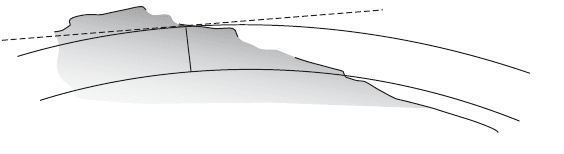
Elevation is measured with respect to a datum surface that is everywhere perpendicular to the direction
of gravity. The datum surface most often chosen is called the geoid. The geoid is an equipotential surface
that closely coincides with mean sea level. Elevations measured with respect to the geoid are called
orthometric heights. The relationships between the mean sea level geoid, a level surface, and a horizontal
line at a point are illustrated in Fig. 54.3.
Benchmark (BM)
A benchmark is best described as a permanent, solid point of known elevation. Benchmarks can be
concrete monuments with a brass disk in the middle, iron stakes driven into the ground, or railroad
spikes driven into a tree, etc.
D
corrected
DS
D
10
6
-------
˯
ʈ
+=
SA
Bp
t 273.2+
---------------------+=
s
cs
ppm
+()±=
© 2003 by CRC Press LLC
Plane Surveying 54-7
Turning Point (TP)
A turning point is a point used in the differential leveling process to temporarily transfer the elevation
from one setup to the next.
Types of Instruments
Elevation may be measured by several methods. Some of these methods measure elevation directly,
whereas some measure the difference in elevation from a reference benchmark to the point to be
determined. Many types of instruments have been used for leveling purposes. The instruments have
ranged from water troughs and hoses to instruments such as the barometer, dumpy level, automatic level,
and laser. The field engineer should realize how each of these can be used to determine elevations for
vertical control and construction.
Altimeters
Surveying altimeters are precise aneroid barometers that are graduated in feet or meters. As the altimeter
is raised in elevation, the barometer senses the atmospheric pressure drop. The elevation is read directly
on the face of the instrument. Although the surveying altimeter may be considered to measure elevation
directly, best results are obtained if a difference in elevation is observed by subtracting readings between
a base altimeter kept at a point of known elevation and a roving altimeter read at unknown points in
the area to be surveyed. The difference in altimeter readings is a better estimate of the difference in
elevation because local weather changes, temperature, and humidity that affect altimeter readings are
canceled in the subtraction process. By limiting the distance between base and roving altimeters, accu-
racies of 3 to 5 feet are possible. Other survey configurations utilizing low and high base stations, and/or
leap-frogging roving altimeters, can yield good results over large areas.
Level Bubble Instruments
Level bubble instruments include the builder’s transit level, the transit, and the dumpy level. Each of
these instruments contains a level vial with a bubble that must be centered to be used for leveling. Each
instrument consists of three main components: a four-screw leveling head, a level vial attached to the
telescope, and a telescope for magnification of the objective.
Instruments that use a level bubble to orient the axes to the direction of gravity depend on the bubble’s
sensitivity for accuracy. Level bubble sensitivity is defined as the central angle subtended by an arc of
one division on the bubble tube. The smaller the angle subtended, the more sensitive the bubble is to
dislevelment. A bubble division is typically 2 millimeters long, and bubble sensitivity typically ranges
from 60 seconds to 1 second.
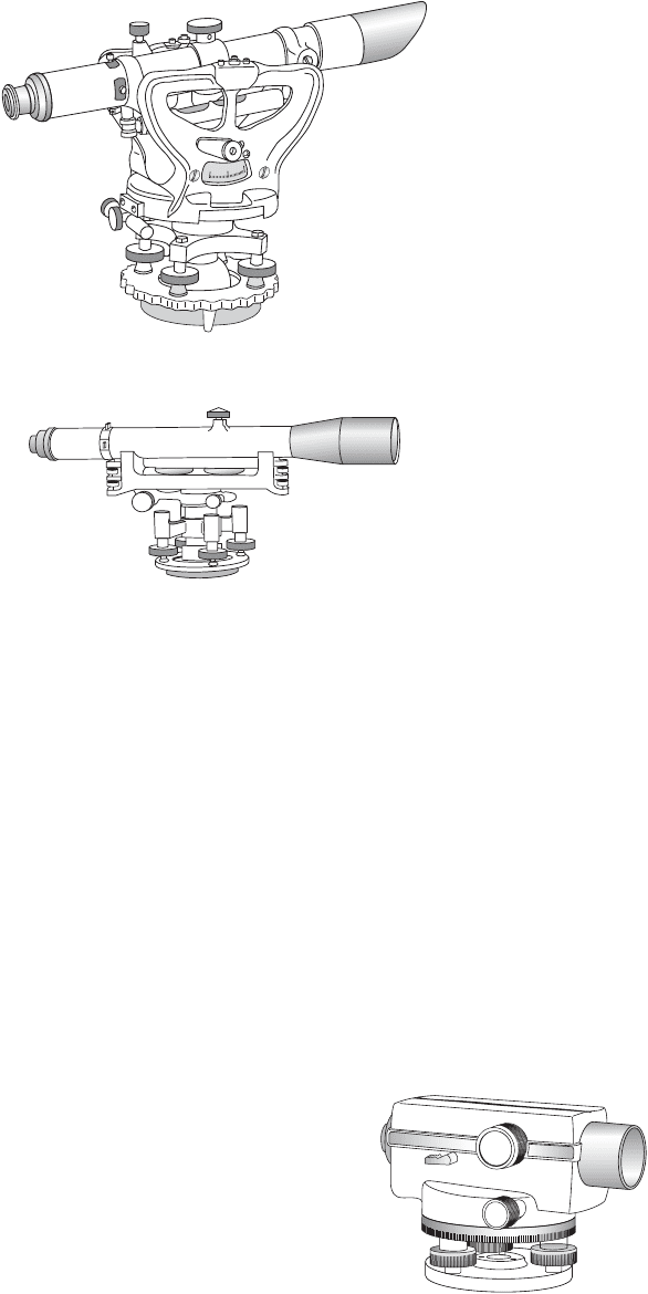
Builder’s Level. The builder’s level is one of the most inexpensive and versatile instruments that is used
by field engineers. In addition to being able to perform leveling operations, it can be used to turn angles,
and the scope can be tilted for sighting. Many residential builders use this instrument because it serves
their purpose of laying out a building. See Fig. 54.4.
FIGURE 54.3 Elevation datum and level surface.
L
E
V
E
L
S
U
R
F
A
C
E
O
C
E
A
N
E
L
E
V
A
T
I
O
N
O
F
P
O
I
N
T
"
A
"
M
E
A
N
S
E
A
L
E
V
E
L
HORIZONTAL LINE
A
© 2003 by CRC Press LLC
54-8 The Civil Engineering Handbook, Second Edition
Transit. Although the primary functions of the transit are for angle measurement and layout, it can also
be used for leveling because there is a bubble attached to the telescope. In fact, many construction
companies who don’t have both an angle measuring instrument and a dumpy or automatic level will do
all of their leveling work with a transit. Some people prefer to use the transit for leveling because they
are comfortable with its operation. However, the field engineer should be aware that the transit may not
be as sensitive and stable as a quality level.
Dumpy Level. The engineer’s dumpy level shown in Fig. 54.5 has been the workhorse of leveling instru-
ments for more than 150 years. It has been used extensively for many of the great railroad, canal, bridge,
tunnel, building, and harbor projects for the last century and a half. Even with advancements in other
leveling instruments such as the automatic level and the laser, the dumpy is still the instrument of choice
for a number of persons in construction because of its stability. On any type of project where there is
going to be a great deal of vibration — such as pile driving, heavy-equipment usage, or high-rise
construction — the dumpy may be the best choice for a leveling instrument.
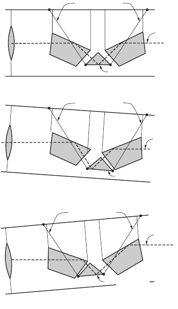
Automatic Compensator Instruments
Compensator instruments illustrated in Fig. 54.6 were developed
about 50 years ago. Although each manufacturer may have developed
a unique compensator, all compensators serve the same purpose —
maintaining a fixed relationship between the line of sight and the
direction of gravity. If the instrument is in adjustment, the line of
sight will be maintained as a horizontal line. The operation of a
compensator is illustrated in Fig. 54.7. Compensator instruments are
extremely fast to set up and level. An experienced person can easily
have an automatic level ready for a backsight in less than ten seconds,
compared to a minute or more with a bubble-based leveling system.
Compensators are available in several styles. Some are constructed
FIGURE 54.4 Builder level.
FIGURE 54.5 Engineer’s dumpy level.
FIGURE 54.6 Automatic level.
© 2003 by CRC Press LLC
Plane Surveying 54-9
by suspending a prism on wires. Some have a prism that is contained within a magnetic dampening
system. Note that the instrument must be manually leveled to within the working range of the compen-
sator by centering a bull’s-eye bubble.
Laser Levels
A laser level uses a laser beam directed at a spinning optical reflector. The reflector is oriented so that
the rotating laser beam sweeps out a horizontal reference plane. The level rod is equipped with a sensor
to detect the rotating beam. By sliding the detector on the rod, a vertical reading can be obtained. Laser
levels are especially useful on construction sites. As the laser beam continuously sweeps out a constant
elevation reference plane, anyone with a detector can get a rod reading to set or check grade elevations.
Laser levels can be equipped with automatic leveling devices to maintain level orientation. The spinning
optics can also be oriented to produce a vertical reference plane.
Digital Levels
Digital levels are electronic levels that can be used to more quickly obtain a rod reading and make the
reading process more reliable. The length scale on the level rod is replaced by a bar code. The digital
level senses the bar code pattern and compares it to a copy of the code held in its internal memory. By
matching the bar code pattern, a rod-reading length can be obtained.
Level Rods
In addition to the leveling instrument, a level rod is required to be able to transfer elevations from one
point to another. The level rod is a graduated length scale affixed to a rod and held vertically on a turning
FIGURE 54.7 Leveling the line of sight by compensator.
WIRE SUPPORTS
WIRE SUPPORTS
WIRE SUPPORTS
LINE OF
SIGHT
LINE OF
SIGHT
LINE OF
SIGHT
LEVEL LINE
OF SIGHT
LEVEL LINE
OF SIGHT
LEVEL LINE
OF SIGHT
COMPENSATOR
COMPENSATOR
COMPENSATOR
TELESCOPE HORIZONTAL
WHEN TELESCOPE TILTS UP
COMPENSATOR SWINGS BACKWARD
WHEN TELESCOPE TILTS DOWN
COMPENSATOR SWINGS FORWARD
© 2003 by CRC Press LLC
54-10 The Civil Engineering Handbook, Second Edition
point or benchmark. The scale is read by the person at the instrument. The reading taken is the vertical
distance from the point to the line of sight.
Level rods are available in many sizes, shapes, and colors. They are made of wood, fiberglass, metal,
or a combination of these materials. There are one-piece rods, two-piece rods, three-piece rods, six-piece
rods, etc. Some have a square cross section and others are round or oval. Some are less than 10 feet long,
while others are up to 30 feet long. Practically whatever type of rod a field engineer needs is available.
Level rods have been named after the cities where they have been manufactured. The Philadelphia rod,
for example, is a two-piece rod that can be extended to approximately 13 feet. It is a popular rod used
in leveling surveys.
A popular rod that doesn’t seem to have a proper name is the telescoping rod. Because a telescoping
rod is 25 or 30 feet long, it is the rod of choice for field engineers working on projects where there is a
great deal of change in elevation. Great rod lengths increase the elevation difference that can be transferred
at one time. It has been argued that these types of rods wear rapidly and therefore aren’t as accurate as
the more traditional rods. If telescoping rods are well cared for, they are excellent for construction use.
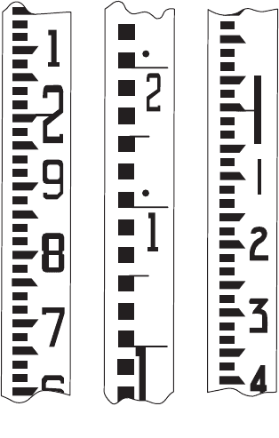
Level rods are graduated in feet, inches, and fractions; feet, tenths, and hundredths; or meters and
centimeters. The method of representing units of measurement onto the face of the rod also varies.
Typical level rod graduations are shown in Fig. 54.8. The field engineer should, after studying the
graduations on the face of the rod, be able to use any rod available. The rod illustrated on the left in
Fig. 54.8 shows the markings on a typical “engineer’s rod” that is widely used on the construction site.
Note that the rod is graduated to the nearest foot with large numbers that are usually painted red. The
feet are then graduated to the nearest tenth from 1 to 9. Each tenth is then graduated to the nearest one
hundredth, which is the width of the smallest mark on the rod.
Rod Targets
Rod targets are useful devices for several purposes. The rod target can be used as a target by the person
looking through the instrument to help locate the rod when visibility conditions are poor. If the rod
target has a vernier, it can also be used to obtain a reading on the rod to the nearest thousandth of a
foot. In this case the instrument person communicates to the rod person to move the target until it has
FIGURE 54.8 Typical level rod graduations.
Engineers Metric
Direct
Elevation
© 2003 by CRC Press LLC
Plane Surveying 54-11
centered on the horizontal cross hair. The rod person can then read the rod and the vernier to obtain
thousandths of a foot. This accuracy is sometimes required on very precise leveling work.
Rod Levels
Rod levels are used to keep the level rod plumb while the reading is being taken. Rod levels are simple
devices made of metal or plastic and have a bull’s-eye bubble attached. They are held along the edge of
the level rod while the level rod is moved until the bubble is centered. If the rod level is in proper
adjustment, the rod is plumb. When a rod level is not used, the rod person should slowly rock the rod
through the vertical position. The instrument person watches the cross hair appear to move on the rod
and records the lowest reading — the point when the rod was vertical.
Turning Point Pin
If a solid natural point is not available during the leveling process to be used as a turning point, then
the field engineer will have to create one. This is accomplished by carrying something such as a railroad
spike, piece of rebar, wooden stake, or plumb bob that can be inserted solidly into the ground. The rod
is placed on top of the solid point while the foresight and backsight readings are taken. These solid points
are removed after each backsight to be used the next time a solid turning point is needed.
Fundamental Relationships
All level instruments are designed around the same fundamental relationships and lines. The principal
relationships among these lines are described as follows:
•The axis of the level bubble (or compensator) should be perpendicular to the vertical axis.
•The line of sight should be parallel to the axis of the level bubble.
When these instrument adjustment relationships are true and the instrument is properly set up, the
line of sight will sweep out a horizontal plane that is perpendicular to gravity at the instrument location.
However, several effects must be considered if the instrument is to be used for differential leveling.
Earth Curvature
The curved shape of the earth means that the level surface through the telescope will depart from the
horizontal plane through the telescope as the line of sight proceeds to the horizon. This effect makes
actual level rod readings too large by
where D is the sight distance in thousands of feet.
Atmospheric Refraction
The atmosphere refracts the horizontal line of sight downward, making the level rod reading smaller.
The typical effect of refraction is equal to about 14% of the effect of earth curvature. Thus, the combined
effect of curvature and refraction is approximately
Instrument Adjustment
If the geometric relationships defined above are not correct in the leveling instrument, the line of sight
will slope upward or downward with respect to the horizontal plane through the telescope. The method
of testing the line of sight of the level to ensure that it is horizontal is called the two-peg test. It requires
setting up the level exactly between two points about 200 feet apart and subtracting readings taken on
the points to determine the true difference in elevation between them. The instrument is then moved
and placed adjacent to one of the points, and rod readings are again taken on the two points. If the line
C 0.0239D
2
=
Cr–()0.0206D
2
=
© 2003 by CRC Press LLC
54-12 The Civil Engineering Handbook, Second Edition
of sight of the instrument is truly horizontal, the difference in elevation obtained from the two setups
will be the same. If the line of sight is inclined, the difference in elevation obtained from the two setups
will not be equal. Either the instrument must be adjusted, or the slope of the line of sight must be
calculated. The slope is expressed as a collimation factor, C, in terms of rod-reading correction per unit
sight distance. It may be applied to each sight by
In ordinary differential leveling discussed next, these effects are canceled in the field procedure by
always setting up so that the backsight distance and foresight distance are equal. The errors are canceled
in the subtraction process. If long unequal sight distances are used, the rod readings should be corrected
for curvature and refraction and for collimation error.
Ordinary Differential Leveling
Determining or establishing elevations is, at times, the most essential activity of the field engineer.
Elevations are needed to set slope stakes, grade stakes, footings, anchor bolts, slabs, decks, sidewalks,
curbs, etc. Just about everything located on the project requires elevation. Differential leveling is the
process used to determine or establish those elevations.
Differential leveling is a very simple process based on the measurement of vertical distances from a
horizontal line. Elevations are transferred from one point to another through the process of using a leveling
instrument to read a rod held vertically on, first, a point of known elevation and, then, on the point of
unknown elevation. Simple addition and subtraction are used to calculate the unknown elevations.
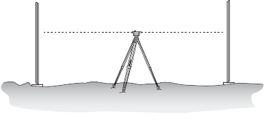
A single-level setup is illustrated in Fig. 54.9. A backsight reading is taken on a rod held on a point of
known elevation. That elevation is transferred vertically to the line of sight by reading the rod and then
adding the known elevation and the backsight reading. The elevation of the line of sight is the height of
instrument, HI. By definition, the line of sight is horizontal; therefore, the line of sight elevation can
then be transferred down to the unknown elevation point by turning the telescope to the foresight and
reading the rod. The elevation of the foresight station is found by subtracting the rod reading from the
height of instrument. Note that the difference in elevation from the backsight station to the foresight
station is determined by subtracting the foresight rod reading from the backsight rod reading.
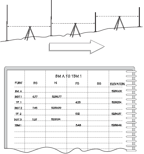
A level route consists of several level setups, each one carrying the elevation forward to the next
foresight using the differential-leveling method. Figure 54.10 shows a short level route and illustrates the
typical format used in the field for differential level notes.
Leveling Closure
Level route closure is obtained by taking the last foresight on a benchmark of known elevation. If a
second benchmark is not available near the end of the level route, the route should be looped back to
the starting benchmark to obtain closure. At the closing benchmark,
FIGURE 54.9 Differential leveling.
BS HI FS
TP
BM + BS = HI
HI - FS = TP ELEV
BM
Corrected rod reading Rod reading C
Factor
D
Sight
◊()+=
© 2003 by CRC Press LLC
Plane Surveying 54-13
Since differential leveling is usually performed with approximately equal setup distances between
turning points, the level route is adjusted by distributing the closure equally to each setup:
where n is the number of setups in the route. When a network of interconnected routes is surveyed, a
least-squares adjustment is warranted.
Precise Leveling
Precise leveling methods are required for engineering work that requires extreme accuracy. The process
requires that special equipment and methods be used. Instruments used in precise leveling are specifically
designed to obtain a high degree of accuracy in leveling. Improved optics in the telescope, improved level
sensitivity, and carefully calibrated rod scales are all incorporated into the differential-leveling process.
Methods have been developed to ensure that mistakes are eliminated and errors are minimized.
Typically when performing precise leveling, a method of leveling called three-wire leveling is used. This
involves reading the center cross hair as well as the upper and lower “stadia” cross hairs. The basic process
of leveling is the same, except that the three cross hair readings are averaged to improve the precision
of each backsight and foresight value.
Another method that can be used to improve the precision of the level rod reading involves using an
optical micrometer on the telescope. The optical micrometer is a rotating parallel-plate prism attached
in front of the objective lens of the level. The prism enables the observer to displace the line of sight
parallel with itself and set the horizontal cross hair exactly on the nearest rod graduation. The observer
FIGURE 54.10 Level route and field note form.
6.77 BS FS 4.23
7.45 BS FS 5.12
7.07 BS FS 3.48
BM
A
TP 1
TP 2
TBM 1
Direction of Leveling
Closure Computed elevation Known elevation–=
Adjustment
Closure
n
------------------
–
˯
ʈ
per setup=
© 2003 by CRC Press LLC
54-14 The Civil Engineering Handbook, Second Edition
adds the middle cross hair rod reading and the displacement reading on the micrometer to obtain a rod
reading precise to the nearest 0.1 millimeter.
When long precise level routes are surveyed, it is necessary to account for the fact that the level surfaces
converge as the survey proceeds north. The correction to be applied for convergence of level surfaces at
different elevations can be calculated by
where f is the latitude at the beginning point, H is the elevation at the beginning point, and Df is the
change in latitude from beginning point to end point in radians.
Trigonometric Leveling
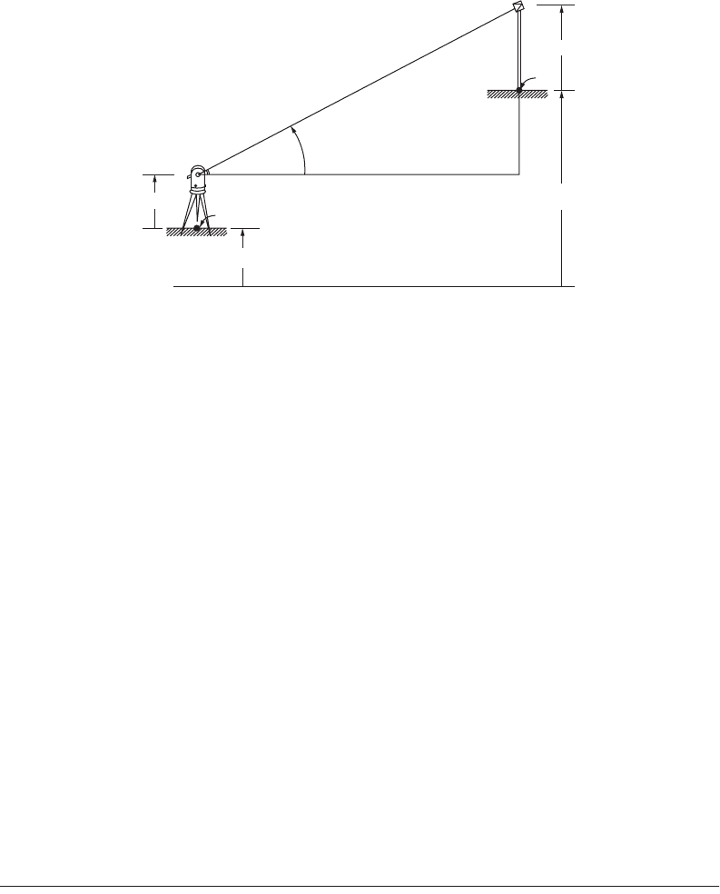
Trigonometric leveling is a method usually applied when a total station is used to measure the slope
distance and the vertical angle to a point. This method is illustrated in Fig. 54.11. Assuming the total
station is set up on a station of known elevation, the elevation of the unknown station is
The precision of trigonometric elevations is determined by the uncertainty in the vertical angle
measurement and the uncertainty in the atmospheric refraction effects. For long lines the effects of earth
curvature and atmospheric refraction must be included.
54.4 Angle Measurement
Horizontal and Vertical Angles
The angular orientation of a line is expressed in terms of horizontal angles and vertical angles. Survey
angles illustrated in Fig. 54.12 are defined by specifying the plane that contains the angle, the reference
line or plane where the angle starts, the direction of turning, and the terminal line or plane where the
angle ends.
Field angles that are measured in the horizontal plane include clockwise angles, counterclockwise
angles, and deflection angles. The clockwise angle or “angle to the right,” shown in Fig. 54.13, is measured
from a backsight line, clockwise in the horizontal plane, to a foresight line. All transits or theodolites
FIGURE 54.11 Trigonometric leveling in plane surveying.
Datum
HR
P
P
Elev
A
Elev.
V
S
Slope Distance
H
A
HI
a
Correction 0.0053 2
f
HD
f
rad
sin–=
VS
a
sin=
P
Elev
A
Elev
HI V HR–++=
© 2003 by CRC Press LLC