Carranza E. Geochemical anomaly and mineral prospectivity mapping in GIS
Подождите немного. Документ загружается.


6 Chapter 1
knowledge has led to theories or generalisations about dispersion of elements and
surface geochemical expressions of mineralisation (Bradshaw, 1975; Kauranne, 1975;
Lovering and McCarthy, 1978; Butt and Smith, 1980; Smith, 1987) and genesis of
mineral deposits (e.g., Lindgren, 1933; Pirajno, 1992; Evans, 1993; Richards and Tosdal,
2001; Robb, 2004). Therefore, many cases of predictive modeling involved in target
generation commence with deduction, although switching to induction may be necessary
at intermediate steps until a final predictive model is obtained.
Types of predictive modeling
This section reviews the types of predictive modeling that are relevant to mineral
exploration, especially in the target generation phase. There is no generally accepted
classification of types of predictive modeling of Earth systems such as geochemical
anomalies and prospective areas. However, based on the way inter-predictor
relationships and target-predictor relationships are described or represented, two types of
Fig. 1-1. (A) Existing lithologic map and measured Fe (%) contents in ridge-and-spur soil
samples. The measured Fe contents in soil generally decrease with distance from the basalt. (B)
Best-fit line model for measured Fe contents in soil and distance to the basalt. (C) Updated
lithologic map after field investigation of residuals (measured-predicted) of Fe in soil.
Predictive Modeling of Mineral Exploration Targets 7
predictive modeling – mechanistic and empirical – and hybrids of these two types can be
distinguished (cf. Harbaugh and Bonham-Carter, 1970).
Mechanistic modeling applies fundamental or theoretical knowledge of individual
predictor variables (i.e., processes) and their interactions in order to predict or
understand the target variable of interest. Mechanistic modeling is therefore equivalent
to theoretical modeling. Mechanistic modeling relies on mathematical equations to
describe the interactions of processes that control the behaviour of system of interest. It
applies relevant physical laws and is often based on laboratory studies, field experiments
and physical models. Solving the theoretical equations in mechanistic modeling can be
complex and require application of generalising or simplifying assumptions (e.g.,
simplified geometry, homogeneity, idealised initial conditions and boundary conditions).
Mechanistic modeling therefore invariably follows a deductive approach. The predictive
capability of a mechanistic model can be determined and then improved via probabilistic
uncertainty analyses to investigate sensitivity of prediction to one or more predictor
variables or assumptions.
There are two sub-types of mechanistic modeling – deterministic and stochastic.
Deterministic modeling applies mathematical representations (e.g., differential
equations) of the processes that control the behaviour of system of interest. It makes
definite predictions of quantities (e.g., metal concentrations) without considering any
randomness in the distributions of the variables in the mathematical equations.
Stochastic modeling also applies mathematical representations of the processes that
control the behaviour of system of interest, but it considers the presence of some random
distribution in one or more predictor variables and in the target variable. Stochastic
modeling therefore does not result in single estimates of the target variable but a
probability distribution of estimates, which is derived from a large number of
simulations (stochastic projections), reflecting random distributions in the predictor and
target variables. Purely deterministic modeling has been rarely, if not never, used in
mineral exploration, except in laboratory studies of mineral deposit formation (e.g.,
L’Heureux and Katsev, 2006). Purely stochastic modeling is seldom used in the target
generation phase of mineral exploration, but it has been applied, however, in the
resource estimation and reserve definition phases of mineral exploration (e.g., Sahu,
1982; Harris, 1984; Sahu and Raiker, 1985).
An interesting application of stochastic modeling is where the target variable sought
represents fractal geo-objects as a result of stochastic rather than deterministic processes.
A fractal geo-object is one which can be fragmented into various parts, and each
fragment has similar geometry as the whole geo-object (Mandelbrot, 1983).
Geochemical dispersion patterns and spatial distributions of mineral deposits are
postulated to be fractals (Bölviken et al., 1992; Agterberg et al., 1993b). Agterberg
(2001) and Rantitsch (2001) have demonstrated the utility of stochastic modeling to
examine the fractal geometry of geochemical landscapes, as conventional geostatistical
methods are not able to do so when the spatial variability of geochemical anomalies
exceeds the spatial resolution (i.e., sampling density) of geochemical data sets. Hybrids
of stochastic modeling (not based on assumption of fractals) and quantitative empirical
8 Chapter 1
modeling (see below) have been applied, however, in mapping of significant
geochemical anomalies (e.g., Singer and Kouda, 2001; Agterberg, 2007) and prospective
areas (e.g., Agterberg, 1974; Pan et al., 1992; Grunsky et al., 1994).
In contrast to mechanistic modeling, empirical modeling is appropriate when the
underlying geochemical and/or physical processes that control the behaviour of the
system of interest are insufficiently or indirectly known. Methods for empirical modeling
do not take into account interactions of such processes in a mathematical sense as in
mechanistic modeling. Instead, they characterise or quantify the influence of one or more
of such processes on the behaviour of the system of interest via empirical model
equations. Empirical modeling is therefore equivalent to symbolic modeling and
generally follows an inductive approach. The equations in empirical modeling are
constructed to define relationships between the target variable and a number of predictor
variables representing processes in order to describe or symbolise the observed or
predicted behaviour of the system of interest. Empirical modeling requires substantial
amounts of data of both the target and predictor variables in order to quantify accurately
their relationships. In terms of sufficiency of data of the target variable, there are two
sub-types of empirical modeling – quantitative and qualitative.
Quantitative empirical modeling is appropriate when data of the target variable are
sufficient to obtain, say, statistically significant results. Data of the target variable are
usually divided into a training set and a testing set. Based on a training set, relationships
between the target and predictor variables are quantified and then used for prediction.
Methods for quantitative empirical modeling can be statistical, probabilistic or
mathematical. The quality of a quantitative empirical model is described by its
goodness-of-fit to data in a training set and its predictive ability against data in a testing
set. In mapping of prospective areas, quantitative empirical modeling is also known as
data-driven modeling. In contrast, qualitative or heuristic modeling is appropriate when
data of the target variable are insufficient or absent. In qualitative modeling,
relationships between the target and predictor variables are defined based on expert
opinion. Qualitative modeling thus seems to follow a deductive approach. The quality of
a qualitative empirical model can be described by its predictive ability against available
(albeit insufficient) data of the target variable. In mapping of prospective areas,
qualitative empirical modeling is also known as knowledge-driven modeling.
Based on the preceding discussion, further distinctions between mechanistic
modeling and empirical modeling can be made as follows. Whereas mechanistic
modeling attempts to characterise and understand the fundamental or theoretical
processes that control the behaviour of the system of interest, empirical modeling
attempts to depict quantitatively the influence of well-understood processes on the
behaviour of the system of interest. Therefore, mechanistic modeling strives to derive
realistic predictive models, whereas empirical modeling endeavours to derive
approximate yet plausible predictive models. Furthermore, mechanistic modeling is
dynamic, because it can contain the time variable in the mathematical equations
especially in deterministic modeling; whereas empirical modeling usually ignores the
time variable and is therefore static. Predictive modeling of geochemical anomalies,
Predictive Modeling of Mineral Exploration Targets 9
however, can be dynamic, especially modeling of drainage and soil geochemical
anomalies (e.g., Tardy et al., 2004). Predictive modeling of prospective areas, however,
is usually static. Finally, mechanistic and empirical modeling can be one-dimensional (1-
D), two-dimensional (2-D), three-dimensional (3-D) or four-dimensional (4-D). The
following sections review the concepts and practises of only 2-D mapping or predictive
modeling of significant geochemical anomalies and prospective areas, which comprise
the scope of this volume.
PREDICTIVE MODELING OF SIGNIFICANT GEOCHEMICAL ANOMALIES
Exploration geochemical data are generated in mineral exploration programmes
through systematic measurements of one or more chemical properties of samples of
certain Earth materials (sediment, water, soil, rock, vegetation, gas, etc.). Detailed
explanations of concepts and practises of sampling different Earth materials for mineral
exploration can be found in Levinson (1974), Rose et al. (1979), Govett (1983), Butt and
Zeegers (1992), Kauranne et al. (1992), Hale and Plant (1994) and Hale (2000). In most
cases, the chemical property determined from each sample is the concentration of one or
more elements. Such element content determinations aim to find areas with enriched
concentrations of one or more indicator or pathfinder elements, which could betray the
presence of mineral deposits of the type sought.
The normal concentration of an element in non-mineralised Earth materials is
referred to as background. It is more realistically viewed as a range of values rather than
an absolute value because the distribution of any element in any particular Earth material
is rarely uniform and varies considerably from one type of Earth material to another and
from one location to another. Therefore, uni-element background is determined by
stochastic, empirical or hybrid stochastic-empirical modeling techniques whenever a
new area is explored for certain types of mineral deposits. The upper limit of the range
of background values is called the threshold. Uni-element concentrations greater than the
threshold are collectively called anomaly. Anomalous uni-element concentrations that
indicate presence of mineral deposits are called significant anomalies.
The spatial variations of concentrations of any element can be called geochemical
landscape; therefore, background and anomaly both occupy space. Areas characterised
by normal concentrations of indicator or pathfinder elements are called background,
whereas areas characterised by concentrations of at least one indicator or pathfinder
element greater than the threshold are called anomalies. In an exploration area,
anomalies can be delineated once threshold values in individual uni-element data sets are
determined. The different methods used traditionally in modeling of geochemical
thresholds can be classified broadly into two categories of analysis, namely (Levinson,
1974; Rose et al., 1979; Howarth, 1983b): (1) analysis of frequency distributions of uni-
element concentrations; and (2) analysis of multi-element associations. In the latter, the
concept of threshold in uni-element concentration data is extended to data values derived
from analysis and synthesis of multi-element data sets by application of multivariate
statistical methods.
10 Chapter 1
The traditional methods applied in modeling of uni-element geochemical anomalies
include (Levinson, 1974; Govett et al., 1975; Rose et al., 1979; Sinclair, 1983; Howarth
and Sinding-Larsen, 1983): (a) comparison of data from the literature; (b) comparison of
data with results of an orientation geochemical survey; (c) graphical discrimination from
a data histogram; (d) calculation of threshold as the sum of the mean and some multiples
of the standard deviation of data; (e) plotting cumulative frequency distributions of the
data and then partitioning the data into background and anomalous populations; (f) (e)
constructing normal probability plots of the data and then partitioning the data into
background and anomalous populations and (f) recognition of clusters of anomalous
samples when data are plotted on a map.
The traditional methods applied in modeling of multi-element geochemical
anomalies include (Rose et al., 1979; Howarth and Sinding-Larsen, 1983): (a) stacking
uni-element anomaly maps of the same scale on top of each other on a light table and
then outlining areas with multiple intersections of uni-element anomalies; (b)
determining inter-element correlations, usually by calculating Pearson correlation
coefficient; (c) recognising and quantifying multi-element associations based on their
correlations; and (d) mapping of quantified multi-element association scores.
Applications of certain methods to model multi-element geochemical anomalies
invariably require computer processing because such techniques are prohibitively
difficult and time-consuming to perform manually. In addition, conventional methods for
recognising and mapping multi-element associations vary depending on whether a-priori
knowledge is available or not about certain controls on geochemical variations.
Principal components analysis and cluster analysis are conventional methods in
identifying and mapping multi-element associations without a-priori information about
controls on geochemical variations or which samples were collected at or near
mineralised zones. In more recent times, fuzzy cluster analysis based on the fuzzy set
theory (Zadeh, 1965) has been demonstrated to be more advantageous than the
conventional cluster analysis in identifying boundaries of anomalous multi-element
clusters and quantifying degrees of membership of samples to every fuzzy cluster (Yu
and Xie, 1985; Vriend et al., 1988; Kramar, 1995; Rantitsch, 2000).
In situations where some controls on geochemical variations are known a-priori, a
simple conventional approach to recognise and map significant geochemical anomalies
is to apply element ratios (Plimer and Elliot, 1979; Brand, 1999; Garrett and Lalor,
2005). When scavenging effects of Fe-Mn oxides on variations of certain elements are
known a-priori or recognised during the analysis of inter-element correlations, a usual
approach is to apply regression analysis to estimate concentrations of certain elements as
a function of Fe and Mn contents in order to interpret if geochemical residuals depict
anomalous patterns or not. When it is known a-priori that some samples were collected
at or near mineralised zones, such samples can be used as a training set in discriminant
analysis to determine if the other samples are associated with mineralisation or not.
Alternatively, logistic regression analysis can be performed by using binary data [0,1] of
mineral deposit occurrence as target variable and the multi-element data as predictor
variables to derive predicted mineral deposit occurrence scores for each sample.
Predictive Modeling of Mineral Exploration Targets 11
Traditionally, modeling and mapping of significant geochemical anomalies were
based mostly on geochemical data sets, probably because in the past (say, before the
1970s when the development of GIS was at its infancy) many outcropping mineral
deposits were still undiscovered such that their associated geochemical anomalies are
obvious in the data sets. However, not all geochemical anomalies indicate the presence
of mineral deposits. Mineral deposits are themselves significant geochemical anomalies.
In more recent times, it can be surmised that most, if not all, outcropping mineral
deposits have already been discovered. In addition, mining and other industries have
already altered the geochemical landscapes. Therefore, an obvious geochemical anomaly
may be geogenic and significant (i.e., associated with mineral deposits), geogenic but
non-significant (i.e., related to certain high background non-mineralised lithologies), or
anthropogenic and non-significant (e.g., due to industrial contamination). In contrast, a
subtle geochemical anomaly or absence of a geochemical anomaly does not necessarily
indicate absence of mineral deposits, but may suggest either that weathering and erosion
rates were insufficient to mobilise and disperse metals from mineralised sources or that
mineral deposits are ‘blind’ or ‘buried’ (i.e., non-outcropping or unexposed to the
surface). It is clear, therefore, that effective modeling of significant geochemical
anomalies requires that all available relevant exploration data sets or pieces of geo-
information are analysed and integrated in the light of fundamental or theoretical
principles of exploration and environmental geochemistry.
Many modern methods for modeling of significant geochemical anomalies
subsequently consider not only geochemical data frequency distributions but also other
types of geo-information from uni-element or multi-element geochemical data sets (e.g.,
Grunsky and Agterberg, 1992; Bellehumeur et al., 1994; Cheng et al., 1996, 1997, 2000;
Cheng, 1999b; Harris et al., 2001a; Karger and Sandomirsky, 2001), namely: spatial
variability and correlations; geometry (shape and orientation, as well as fractal
dimensions) of anomalies; and scale independence of anomalies. Consideration of the
scale independence of anomalies aims to reduce the effects of sampling density and geo-
analytical techniques on the spatial distributions of geochemical anomalies.
Considerations of the spatial variability and correlations and the geochemical properties
of geochemical anomalies aim to enhance anomaly patterns that reflect controls by
geological processes and thus facilitate recognition of significant geochemical
anomalies. Enhancement of geochemical anomaly patterns that reflect controls by
geological processes can also be addressed by integrating geochemical data with other
types of relevant spatial data or pieces of spatial geo-information that explicitly represent
individual processes. For example, significant drainage geochemical anomalies can be
enhanced and thus recognised by integrating geochemical data with area of drainage
catchment basins (Polikarpochkin, 1971; Hawkes, 1976; Moon, 1999), lithologic units
(Rose et al., 1970; Bonham-Carter and Goodfellow, 1986; Bonham-Carter et al., 1987),
proximity to faults (Carranza and Hale, 1997); drainage sinuosity (Seoane and De Barros
Silva, 1999), and stream order (Carranza, 2004a). Significant soil geochemical
anomalies can be enhanced and thus recognised by integrating soil geochemical data
chiefly with lithology (e.g., Lombard et al., 1999; Garrett and Lalor, 2005; Jordan et al.,
12 Chapter 1
2007) and sometimes with topographic elevation (Grunsky and Smee, 1999; Grunsky,
2006). Subtle but significant geochemical anomalies can also be enhanced and
recognised by applications of selective or partial extraction geo-analytical techniques to
measure element concentrations (e.g., Smee, 1998); however, geo-analysis of element
contents in geochemical samples is a topic that is beyond the scope of this volume. We
now turn to modeling of mineral prospectivity by integrating mapped evidential features
such as significant geochemical anomalies.
PREDICTIVE MODELING OF MINERAL PROSPECTIVITY
The term mineral prospectivity refers to the chance or likelihood that mineral
deposits of the type sought can be found in a piece of land. It is similar to the terms
mineral potential and mineral favourability, which refer to the chance or likelihood that
mineral deposits of the type sought are contained in a piece of land. The terms mineral
prospectivity, mineral potential and mineral favourability are therefore synonymous and
can be used interchangeably. For consistency, the term mineral prospectivity is used in
this volume. Because the presence of mineral deposits of the type sought is betrayed by
the presence of certain evidential features (e.g., significant geochemical anomalies),
mineral prospectivity is thus related to the degree of presence of evidential features.
Thus, modeling mineral prospectivity intrinsically assumes, as illustrated in Fig. 1-2, that
(a) a specific location is prospective if it is characterised by the same or similar
evidential features as known locations of mineral deposits of the type sought and (b) if
more important evidential features are present in one location than in another location in
a mineralised landscape, then the former has higher mineral prospectivity than the latter..
Modeling of mineral prospectivity is involved at every scale, from regional-scale to
local-scale, of exploration target generation (cf. Hronsky and Groves, 2008). It is
concerned with the analysis and integration of evidential features derived from multi-
source geoscience spatial data sets in order to delineate and rank prospective areas for
further exploration of undiscovered mineral deposits of the type sought. In regional-scale
target generation, modeling of mineral prospectivity aims to delineate the most
prospective areas within large permissive regions. In district- to local-scale target
generation, modeling of mineral prospectivity aims to define the most prospective zones
or sites within regional-scale prospective areas. This means that from regional-scale to
local-scale mineral exploration, geoscience data sets used in modeling of mineral
prospectivity should have increasing detail and accuracy both in terms of spatial
resolution and information content.
A predictive model of mineral prospectivity must pertain to just one type of mineral
deposit. Thus, a mineral prospectivity model for epithermal Au deposits is not applicable
to guide exploration for porphyry Cu deposits, and vice versa. In any scale of target
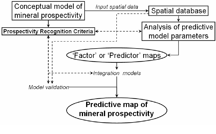
generation, however, modeling of mineral prospectivity follows specific steps starting
with the definition of a conceptual model of mineral prospectivity for mineral deposits of
the type sought (Fig. 1-3). Such a conceptual model is prescriptive rather than predictive,
as it specifies in words and/or diagrams the theoretical relationships between various
Predictive Modeling of Mineral Exploration Targets 13
geologic processes or controls in terms of how and especially where mineral deposits of
the type sought are likely to occur. Defining a conceptual model of prospectivity for
mineral deposits of the sought in a study area requires support of published knowledge
of the various geological processes relevant to the formation of mineral deposits of the
type sought. It is important to review mineral deposit models (e.g., Cox and Singer,
1986; Roberts et al., 1988; Berger and Drew, 2002), which describe the geological
characteristics of specific types of mineral deposits, especially the type of mineral
deposits sought in a study area, and their regional geological environments. Because the
occurrence of several, if not all, types of mineral deposits is related to plate tectonics
(e.g., Mitchell and Garson, 1981; Sawkins, 1989; Pirajno, 1992; Robb, 2004), it is
imperative to review the geotectonic setting of a study area. Moreover, it is useful to
review knowledge about certain geological systems (e.g., faults/fractures) that could act
as controls for mineralisation at geological scales relevant to the stage of target
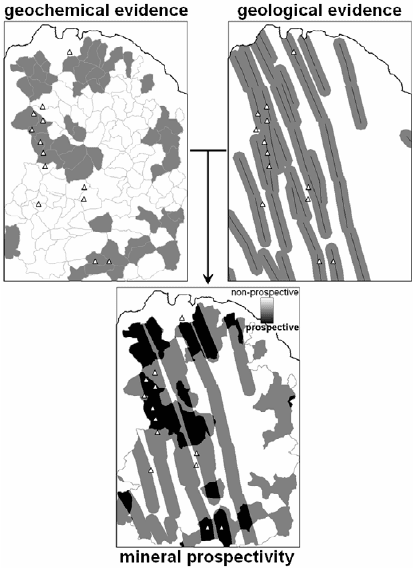
Fig. 1-2. Concept of modeling mineral prospectivity by integration of evidential features (in grey)
like stream sediment catchment basin geochemical anomalies, proximity to faults/fractures, etc.
The degree of mineral prospectivity is related to the degree of s
p
atial coincidence of evidential
features. Locations with the same or similar degree of prospectivity as most known locations
(triangles) of mineral deposits of the type sought are considered new exploration targets.
14 Chapter 1
generation and to the size of the study area. Furthermore, analysis of spatial distributions
of mineral deposits of the type sought (e.g., Carlson, 1991; Vearncombe and
Vearncombe, 1999) and analysis of spatial associations between mineral deposits of the
type sought and certain geological features (e.g., Bonham-Carter, 1985; Carranza and
Hale, 2002b) are useful in defining, testing and, if necessary, re-defining a conceptual
model of mineral prospectivity and the prospectivity recognition criteria. This aspect of
mineral prospectivity modeling is demonstrated in Chapter 6.
The geological, geophysical and geochemical characteristics of areas that contain
mineral deposits of the type sought constitute the prospectivity recognition criteria. The
conceptual model of mineral prospectivity and the prospectivity recognition criteria
provide the framework for mineral prospectivity modeling in terms of determining the
suitable (a) geoscience spatial data sets to be used, (b) evidential features to enhance and
extract from individual geoscience spatial data sets, (c) method of transforming mapped
evidential features into maps of individual prospectivity recognition criteria, (d) method
of weighting classes of individual prospectivity recognition criteria to create predictor
maps and (e) method of integrating predictor maps to create a predictive model or map
of mineral prospectivity. The preceding items (b), (c) and (d) constitute the analysis of
predictive model parameters.
Methods of enhancing and extracting evidential features representing a prospectivity
recognition criterion are specific to evidential themes (i.e., geochemical, geological,
geophysical) and types of geoscience spatial data. The concepts of mapping significant
geochemical anomalies are discussed briefly in the previous section and are treated
further in Chapters 3 to 5. Mapping of evidential geological features of certain mineral
Fig. 1-3. Elements of predictive modeling of mineral prospectivity.
Predictive Modeling of Mineral Exploration Targets 15
deposits, such as hydrothermal alterations, could be performed in the field and/or by
using remotely-sensed data sets (e.g., Spatz, 1997; Sabins, 1999; Carranza and Hale,
2002a). Mapping of geological features such as faults and intrusive rocks representing,
respectively, structural and heat-source controls of certain mineral deposits, could be
performed in the field and/or by analysis and interpretation of appropriate geophysical
data sets (Telford et al., 1990; Parasnis, 1997; Kearey et al., 2002). Procedures for
enhancement and extraction of evidential features from geological and geophysical data
sets, however, are beyond the scope of this volume.
Certain geoscience spatial data or certain mapped evidential features require
manipulation or transformation in order to represent a prospectivity recognition criterion.
Data manipulation or transformation involves one or more types of map operations
(Chapter 2), the choice of which depends on the prospectivity recognition criterion to be
represented. For example, a prospectivity recognition criterion of presence of or
proximity to strike-slip faults first requires selection of such faults from the database,
followed by creation of a map of distances to such faults and then discretization of
distances into proximity classes. Likewise, a prospectivity criterion of presence of
geochemical, say Cu, anomalies first requires suitable interpolation of Cu data measured
at discrete locations and then discretization of the interpolated Cu data (Fig. 1-4). The
purpose of manipulating or transforming spatial data or a map of evidential features to
represent certain prospectivity recognition criteria is to model and discretise (or classify
in order to create geo-objects representing) the degree of presence of evidential features
at every location. Methods of weighting of classes of individual prospectivity
recognition criteria in order to create predictor maps involve either knowledge-driven or
data-driven modeling of their spatial associations to mineral deposits of the type sought
(Bonham-Carter, 1994). Data-driven methods of quantifying spatial associations
between classes of prospectivity recognition criteria and mineral deposits of the type
sought are explained further in Chapters 6 and 8. Knowledge-driven methods of
weighting classes of prospectivity recognition criteria with respect to the mineral
deposits of the type sought are explained further in Chapter 7.
Not every data-driven method of quantifying spatial associations between classes of
prospectivity recognition criteria leads directly to creation and then integration of
predictor maps to obtain a predictive map of mineral prospectivity (see Chapter 6). In
addition, not every data-driven method that leads directly to creation of predictor maps
applies knowledge or a conceptual model of the inter-play of geologic controls of
mineral deposits of the type sought in integrating the predictor maps to obtain a
predictive map of mineral prospectivity (see Chapter 8). In contrast, every knowledge-
driven method of creating predictor maps can be used directly in integrating such
predictor maps, although not all such methods apply knowledge or a conceptual model
of the inter-play of geologic controls of mineral deposits of the type sought in integrating
the predictor maps to obtain a predictive map of mineral prospectivity ( see Chapter 7).
Therefore, every method for creating and/or integrating predictor maps has inherent
systemic (or procedural) errors with respect to interactions of geological processes
involved in mineral deposit formation. In addition, every input geoscience spatial data