Carranza E. Geochemical anomaly and mineral prospectivity mapping in GIS
Подождите немного. Документ загружается.

Spatial Data Models, Management and Operations 27
Raster Model
In a raster model, geo-objects are represented by means of subdividing an area into a
regular grid of cells or pixels organised along columns and rows (Fig. 2-5). The
column/row organisation provides reference for the positions of pixels, which can be
linked or georeferenced to a particular spatial coordinate system. The pixels are usually
squares, but can also be of various equilateral shapes with a fixed size denoting the
spatial resolution of a raster model. For example, the 30-m spatial resolution of Landsat
Thematic Mapper imagery means that each pixel in an image measures 30 m by 30 m on
the ground. The raster model is thus concerned with both location and accuracy of
representing geo-objects.
In a raster model, a point geo-object (e.g., mineral deposit occurrence at a regional
scale) is represented by only one pixel, a linear geo-object (e.g., a fault zone at a regional
scale) as inter-connected pixels depicting length, a polygonal geo-object (e.g., a
lithologic unit that is mappable at a certain scale) as adjoining pixels depicting shape.
The choice of a pixel size can make a raster model an unrealistic representation of geo-
objects; thus, it requires compromise between maximising spatial accuracy and
minimising data storage and processing. There are a number of techniques for encoding
data in raster format (e.g., run-length encoding, quadtrees, etc.), which address concerns
in efficiency of data storage and processing (Holroyd and Bell, 1992).
The raster model is efficient for analysis of data within an attribute layer or between
attribute layers (see further below). For a raster layer of an attribute data, operations that
could be performed include neighbourhood analysis, interpolation, proximity analysis,
etc. The column/row organisation of pixels in a raster model allows efficient analysis of
relationships between two or more attribute data layers by overlay operations. The raster
model is also satisfactory for representing surface entities. The grid structure of surface
representations is simple to understand. The raster model, however, is inflexible in
representing surface complexities due to constant pixel size and imparts a global
directionality to a surface model as influenced by the two principal axes of a grid.
Fig. 2-5. Raster representation (grey cells) of geo-objects in Fig. 2-1.
28 Chapter 2
Calculation of surface characteristics such as slope is, however, more realistic with a
raster model than with a TIN model.
Attribute Data Models
In a vector model, each point, line or polygon is assigned the corresponding
attributes of geo-objects they represent. In a raster model, each pixel is assigned the
corresponding attributes of geo-objects it represents. A map layer in a vector or raster
model represents attribute data for a particular variable. For example, a map layer of
stream sediment sample points could represent labels of each point, whilst another map
layer of the same points could describe concentrations of a specific element at each
point. Parts of a study area without data for certain attribute are, in either vector or raster
model, null or undefined.
In a computer system, or more specifically in database terminology (see below),
attribute data represent observed and measured properties of geo-objects. Attribute data
have spatial, temporal or thematic characteristics. Spatial attributes pertain to properties
that vary in space and their variations can be characterised by location, topology and
geometry. Temporal attributes pertain either to age of geo-objects or to a period of data
acquisition. Thematic attributes are neither spatial nor temporal properties but pertain to
some forms of classifications to which geo-objects can be related, for example,
lithology, mineral deposit-type or mineral occurrence (i.e., presence or absence), faults
of certain orientations, etc. In many GIS studies related to mineral exploration, temporal
are thematic attributes are usually considered to be non-spatial.
Attribute data can be classified as either continuous or discrete variables. Continuous
variables take on any value (i.e., real values), whilst discrete variables take on only
certain values (i.e., real integers). Spatial attribute data are mostly continuous variables,
whilst non-spatial data are mostly discrete values. Element concentrations are examples
of a continuous variable, whereas stream order is a discrete variable. Because modeling
of geo-objects involves discretisation of continuous variables and quantisation (i.e.,
numerical representation for quantitative integration) of discrete variables, it is more
didactic to classify attribute data as quantitative or qualitative variables.
Attribute data representing numerical magnitude of geological, geochemical or
geophysical properties are quantitative variables. Data of quantitative variables are
usually measured on either ratio or interval scales and are mostly represented by
continuous values but can also take on discrete values. For example, element
concentrations and temperature are continuous variables measured on ratio scales and on
interval scales, respectively. In contrast, surface reflectance/absorption properties are
continuous variables measured on ratio scales but can be represented discretely as real
integers [0,255] in raster images. Quantitative variables are important forms of attribute
data because they can be manipulated by mathematical operations or transformations,
which are essential to spatial analysis.
Data of qualitative variables usually take on discrete values or labels according to
either ordinal or nominal scales of measurements. A percentile classification of element
concentrations is an example of ordinal measurement scale. Lithology is an example of
Spatial Data Models, Management and Operations 29
nominal or categorical scales of measurements. Qualitative variables, unlike quantitative
variables, usually have to be represented numerically before they can be integrated in
mathematical operations. For example, lithology, which is a qualitative variable, can be
integrated quantitatively in the estimation of local background by representing it
numerically as an areal proportion of a drainage sample catchment basin (see Chapter 5).
A simple numerical representation of qualitative variables is the assignment of discrete
values in either binary or ternary scales of measurement according to a particular
proposition. For example, for a proposition that “this site contains a mineral deposit”,
lithologic units that are unfavourable and favourable host rocks according to genetic
models of the deposit-type sought can be assigned a value of [0] and [1], respectively.
Other examples of types of numerical representations of qualitative variables (but also of
quantitative variables) are fuzzy membership and probability, which range in the interval
[0,1] reflecting degrees of non-ambiguity and certainty, respectively, with respect to a
proposition (see Chapter 7).
MANAGEMENT OF SPATIAL DATA
In a GIS, management of spatial data is concerned with (1) storing data in the
computer (i.e., spatial data capture) and (2) organising data in the computer (i.e., spatial
database creation). Management of spatial data takes a major proportion of resources
(personnel, time and money) in any GIS-based project.
Spatial Data Capture
The first fundamental step in spatial data capture is to choose a coordinate system,
into which all geo-objects or data are geographically-registered or georeferenced. A
coordinate system consists of a spheroid (or an ellipsoid) representing the Earth’s
surface and a map projection to convert spherical or geographical coordinates (latitudes,
longitudes) to planar or map (metric) coordinates. The choice of an appropriate
coordinate system can benefit from the authoritative discussions on spheroids and map
projections given by Maling (1992) and Snyder (1993). On the one hand, the choice of
an ellipsoid depends on global surface curvatures, such that for every region or country
there is a commonly used ‘best fit’ ellipsoid (Table 2-I). On the other hand, the selection
of a map projection depends on (a) geographic position of region or country, (b) size and
shape of region or country where a study area is situated and (c) requirements or
objectives of the study. These three factors must be considered together if the primary
aim is to obtain minimum geometric distortions in terms of either shape or area.
There are different types of map projections and each map projection creates
geometric distortions but guarantees a known relationship between locations on a map
and their true locations on the Earth. It is essential to use a map projection because
geographical coordinates are not planar coordinates and most spatial data are visualised
as 2-D features using planar coordinates. Although spatial data can be stored and
manipulated using geographical coordinates, storing spatial data using map projections

30 Chapter 2
avoids iterative conversion from geographic coordinates to planar coordinates each time
spatial data are visualised.
A cylindrical projection is appropriate for countries lying in the tropical latitudes
about the equator, whilst a conical projection is appropriate for countries lying in
temperate latitudes and an azimuthal projection is appropriate for countries lying in the
polar regions. A cylindrical projection is suitable for large-size rectangular regions such
as Russia, whilst a conical projection is suitable for medium-size triangular regions such
as India, and an azimuthal projection is suitable for small-size circular regions such as
the Netherlands. The property of a map projection must be considered depending on the
purpose or requirements of mapping. Equal-area projections are appropriate for mapping
in which accurate area measurements are required, whilst orthomorphic (or conformal)
projections are appropriate for mapping in which accurate angular measurements are
required, and equal-distance projections are appropriate for mapping in which accurate
distance measurements are required.
Once a suitable coordinate system is chosen, the capture of spatial data to a database
can be initiated. Table 2-II lists possible methods of capture of analogue or digital spatial
data. Analogue data are usually in paper form (e.g., paper maps, positive prints of aerial
photographs, etc.) and thus not computer-readable in contrast to digital data. Analogue
data can be either encoded directly into a GIS database or encoded digitally using
different software and imported later into a GIS. Capturing data from analogue maps or
images is often carried out either by (a) manual digitisation of maps or images mounted
on digitising tables, (b) manual on-screen digitisation of optically (raster) scanned maps
or images or (c) automatic feature extraction from scanned maps or images (Ansoult et
al., 1990). The accuracy of digitising maps or images depends upon the accuracy of
carefully-selected control points on the map/image being digitised and upon the skill of
the operator. The selection and digitisation of control points is vital for geocoding the
data – the process of geographic registration of locations of geo-objects. Specific
TABLE 2-I
Commonly used spheroids of coordinate systems: year developed, length of semi-axes and usage.
Lengths of semi-axes (m)
Name Year
Major Minor
Geographical usage
Everest 1830 6377276 6356075 India, Sri Lanka, Myanmar
Bessel 1841 6377397 6356079 Central Europe, Chile, China, Indonesia
Airy 1849 6377563 6356257 Great Britain
Clarke 1866 6378206 6356584 North America, Philippines
Clarke 1880 6378249 6356515 France, Africa (parts)
International 1924 6378388 6356912 Whole word except North America and Africa
Krasovsky 1940 6378245 6356863 Russia, Eastern Europe
IAU65 1965 6378160 6356775 Australia
GRS80 1980 6378137 6356752 North America
WGS84 1984 6378137 6356752 Whole world

Spatial Data Models, Management and Operations 31
procedures for manual digitising vary depending on software used. Digital data can be
imported directly into a GIS database; however, many digital data often require
conversion to correct format for use in a specific GIS. Most GIS software packages have
routines for importing and converting digital data through a variety of interchange
formats. Again, it is important that the original geographical coordinates of digital data
are converted into the working coordinate system.
Spatial Database Creation
A spatial database is an organised collection of geographically-referenced data and
their attributes. A database approach is favoured in GIS because it overcomes problems
with traditional methods of data management and it provides or supports the following
functions (Stern, 1995):
storage and manipulation of very large data sets;
control over data redundancy;
data security and integrity;
database models;
concurrent use of data;
back-up and recovery functions;
spatial query languages; and
low maintenance costs.
TABLE 2-II
Methods of capturing geoscience spatial data from different sources.
Example data Data source Source type Possible encoding methods
Analogue
Keyboard entry
Text scanning
Analytical results for
geochemical samples
Tables
Digital
File transfer
File format conversion on import
Analogue
Manual digitising
Raster scanning then on-screen digitising
Automatic feature extraction
Maps
Digital
File transfer
File format conversion on import
Analogue
Manual digitising
Raster scanning then on-screen digitising
Automatic feature extraction
Lithologic units
Faults/fractures
Drainage lines
Air-photos
Digital
File transfer
File format conversion on import
Lithologic units
Altered rock units
Faults/fractures
Drainage lines
Satellite
imagery
Digital
File transfer
File format conversion on import
Image processing and reformatting
32 Chapter 2
In order to achieve the useful functions of a spatial database, data are handled through a
database management system (DBMS), which is a collection of software for creation and
maintenance of a database. Creation of a spatial database takes a major proportion of
resources in a GIS-based mineral exploration project. There are four major stages in
database creation (Oxborrow, 1989).
Data investigation. The task in this stage is to consider, according to needs or
objectives of a project, the type, quantity and qualities of spatial data to be
included in a database.
Database modeling. The task in this stage, which can be performed independently
of the software used, is to develop a conceptual or logical database model by
analysing characteristics of entities and relationships between entities and
attributes.
Database design. The task in this stage, which depends on the software and its
data model, is to create a practical design for a database. That means, the logical
design of a database produced in the data modeling stage is translated into a
practical design using a DBMS.
Database implementation. The task in this stage is to populate the database with
attribute data. This is followed always by monitoring and upkeep, including fine
tuning, modification and updating of attribute data.
The database models that have been used in different GIS applications are the
hierarchical, network, relational and object-oriented models. The hierarchical model
was useful in geochemical applications around the mid-1980s (Mattiske, 1983). The
hierarchical and network models have some importance in GIS applications to
geological studies (e.g., Lopez-Blanco and Villers-Ruiz, 1995; Wielemaker et al., 2003).
The object-oriented model became an emerging trend and topic of many researches in
GIS applications to geological studies (e.g., Alms et al., 1998; Breunig et al., 1999). The
relational model is now predominantly used in GIS and is most widely used in GIS
applications for geological exploration (e.g., Schmatz et al., 1995; Laxton and Becken,
1996; Colman-Sadd et al., 1997; Pouch, 1997; Diepenbroek et al., 2002). The relational
database model is given some supplementary treatment here; the other database models
are not discussed further.
The relational database model was developed by Codd (1970) based on the relational
algebra. In such a database model, data and relations between them are organised in a 2-
D structure (i.e., table). The terminology of relational databases as compared to the
terminology of traditional tables or simple spreadsheets is given in Table 2-III. Each
table represents data for one entity or theme (e.g., stream sediment geochemical data).
Each row or tuple is a record of different properties of a geo-object (e.g., a sample). Each
column represents an attribute or property. The order of tuples or attributes is trivial as
long as the contents of a table are not changed or the significance of relations is not
altered. Each cell (i.e., intersection between a row and a column) can have only one
value or is left blank if values are unknown or unmeasured. Where relations exist
between different data sets, tables representing such data sets are linked by certain

Spatial Data Models, Management and Operations 33
common attributes designated as keys, through which retrieval, search or query (or so-
called join operations) of data from one table to another is made possible and efficient.
Attributes designated as keys must have entries that are unique; however, there is no
standard to predefine keys. In GIS, location (i.e., coordinate pairs) is usually but tacitly
designated as primary key. On the one hand, for data or tables pertaining to point geo-
objects such as sample locations, unique identifiers of each location (e.g., sample
number) can be designated as key. On the other hand, for data or tables pertaining to
linear or polygonal geo-objects, unique identifiers to be used as keys must first be
created and assigned to each linear or polygonal geo-object. The assignment of unique
identifiers to geo-objects usually takes place during spatial data capture and is
considered during the database modeling stage of spatial database creation. This allows
for an efficient link between maps of different types of geo-objects and their
corresponding attribute tables and therefore allows for efficient analysis of relationships
between geo-objects of interest through suitable spatial data operations. Extensive
explanations about operations on relational databases (or tables) of geoscience
exploration data and their relationships with maps can be found in Bonham-Carter
(1994).
OPERATIONS ON SPATIAL DATA
The focus of the following introductory discussions is on generic concepts of certain
operations rather than on algorithms behind such operations, which could vary in vector-
or raster-based GIS software packages.
Spatial query and selection
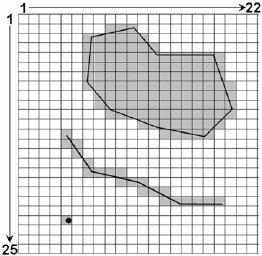
In the early stages of spatial data analysis, it is common to (a) visualise and query the
spatial database and then (b) select locations of spatial data or geo-objects of interest.
Fig. 2-6 shows an example how spatial data or information can be visualised and
queried. Clicking the cursor on any portion of a map view would indicate data attributes
at specific locations, meanwhile an interactive table view could indicate map coordinates
TABLE 2-III
Relational database terminology.
Analogue version Digital version Relational database
Table File Relation
Row Record/case Tuple
Column Field Attribute
Number of rows Number of cases Cardinality
Number of columns Number of fields Degree
Unique ID Primary key Index
Possible values Domain
(
Ada
p
ted from Date, 1990
)
34 Chapter 2
and data attributes at the cursor position. The process of selecting spatial data or geo-
objects for further analysis can then be performed by using either data attribute
conditions or topological relationships of geo-objects.
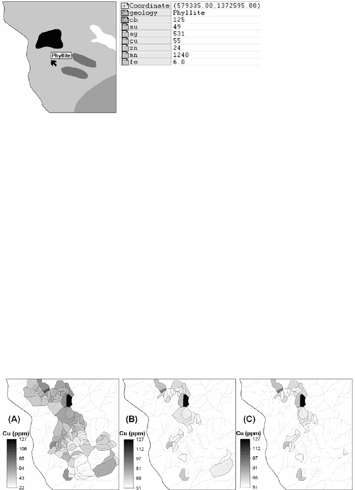
Criteria for selection of certain spatial data by using data attribute conditions are
specified in a query language, which can be a software specific language or a structured
query language (SQL) if the spatial data sets are stored in a relational database. A data
attribute condition criterion to select certain spatial data is called an atomic condition,
which makes use of relational operators (=, <, >, , , etc.). Fig. 2-7A shows a map of
spatial data of interest, whilst Fig. 2-7B shows an output map of selected spatial data
with values above a certain threshold. Two or more attribute condition criteria to select
certain spatial data make up a composite condition, which make use of Boolean logic
operators (AND, OR, NOT, XOR, etc.). The AND operator selects spatial data that meet
all of the attribute condition criteria. The OR operator selects spatial data that meet either
one or all of the attribute condition criteria. The NOT operator selects spatial data that do
not meet all of attribute condition criteria. The XOR operator selects spatial data that
Fig. 2-6. Spatial query of lithologic information by clicking cursor on any part of a lithologic map
or through an interactive table view that indicates, at cursor position, map coordinates and
attributes in the displayed map (‘geology’), and in other maps in the spatial database. The ‘cb’ is
drainage catchment basin number with attributes for certain elements.
Fig. 2-7. Selection of spatial data by using attribute conditions. (A) Input map of Cu data. (B)
Output map using an atomic condition of “Cu>50”. (C) Output map using composite conditions o
f
“Cu>50” AND “lithology=phyllite” (see Fig. 2-6).
Spatial Data Models, Management and Operations 35
meet either one but not all of the attribute condition criteria. Fig. 2-7C shows an output
map generated by selecting from an input map values above a certain threshold and
pertaining to a certain thematic class. This way of selecting spatial data by using data
attribute conditions can be useful, for example, in analysis of geochemical data
pertaining to different lithologies.
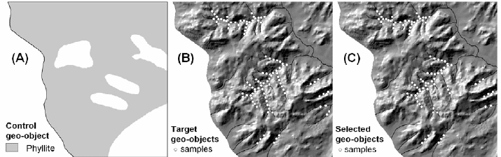
Selection of certain geo-objects of interest based on their topological relationships
(containment, connectivity, adjacency or proximity) with other types of geo-objects is
carried out in two steps. The first step is to decide on a control geo-object for the
selection of target geo-objects. The second step is to apply a spatial relationship of target
geo-objects with the control geo-object. Fig. 2-8 shows a map of a control geo-object, a
map of target geo-objects and a map of selected target geo-objects contained in the
control geo-object. Selection of spatial data by using attribute conditions is useful, for
example, in analysis of geochemical data pertaining to different lithologies. This method
of selecting geo-objects of interest can be useful, for example, in analysis of subsets of
geochemical data pertaining to different lithologies (see Chapter 3).
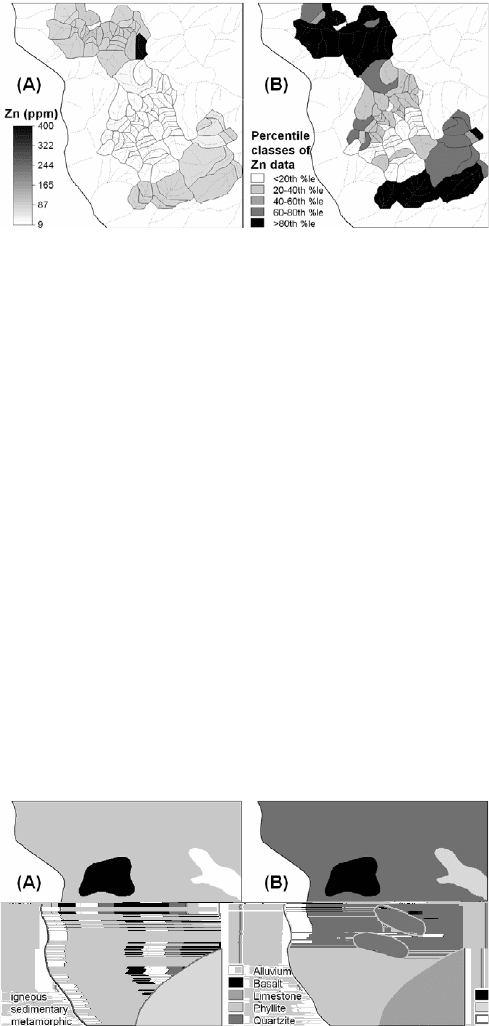
Classification and re-classification
The objective in classification or re-classification is to reduce detail in input data in
order to reveal patterns or spatial distributions of interest. Classification is applied to
spatial data measured on ratio scales. For example, one might be interested to identify
zones of different levels of concentrations of certain metals. This requires partitioning or
classification of geochemical data (point or surface) into different ranges (Fig. 2-9). Re-
classification is applied to spatial data of interval, ordinal and nominal scales. For
example, one might be interested in zones underlain by certain lithologies according to
their mode of genetic formation. This requires re-classification of different lithologic
units according to whether they are igneous, sedimentary or metamorphic rocks (Fig. 2-
10). Classification or re-classification can be carried out via either map or attribute table
calculations. Quantitative attribute data, particularly continuous variables, are more
adequately re-classified via calculations with raster maps (e.g., classification of multi-
Fig. 2-8. Selection of spatial data by using topological relationships. (A) Map of control geo-
object. (B) Map of target geo-objects for selection. (C) Map of selected geo-objects contained only
in the control geo-object.
36 Chapter 2
spectral satellite images), whereas qualitative attribute data are adequately re-classified
via table calculations.
Measurements
Various types of measurement information on vector and/or raster maps can be
obtained: (a) number of point, lines, polygons or pixels; (b) length of lines; and (c)
perimeter and area of polygons. These measurements can be calculated by means of
creating a map histogram of any type of map. The usefulness of measurements depends
on the concern of the analyst. For example, one analyst might wish to check the actual
number of sample location points in order to monitor and update a spatial database. The
number and length of a particular set of lines (e.g., faults) are useful in structural analysis
by way of rose diagrams. Area calculations are useful in fractal analysis and catchment
basin analysis of geochemical anomalies (Chapters 4 and 5, respectively) and in the
analysis of spatial associations between mineral deposits and geological features
(Chapter 6). Areas of polygons (e.g., prospective zones) could also be an important
criterion, in combination with other criteria, for prioritisation of follow-up exploration
work. Note that in raster maps the number of pixels multiplied by the square of the pixel
Fig. 2-9. Stream sediment geochemical data displayed as sample catchment basins. (A) Raw data
of Zn (ppm). (B) Classification of Zn data into classes of 20-percentile intervals.
Fig. 2-10. Re-classification of lithologic units (A) according to their genetic mode (B).