Encyclopedia of Russian History
Подождите немного. Документ загружается.


GENETICISTS
Adherents of a prescriptive theoretical model for
economic development planning in a controversy
of the 1920s.
The geneticists participated in an important the-
oretical controversy with the teleologists over the
nature and potential limits to economic planning.
The issue was fundamental and cut to the heart of
the very possibility of central planning. Would a
central planning agency be constrained by economic
laws, such as supply and demand, or by other fixed
economic regularities, such as sector proportions,
or could planners operate to shape the economic fu-
ture according to their own preferences?
The geneticists argued that it was necessary to
base economic plans on careful study of economic
laws and historical determinants of economic ac-
tivity. The past and certain general laws con-
strained any plan outcome. In this view, planning
was essentially a form of forecasting. The teleolo-
gists argued on the contrary that planners should
set their objectives independently of such con-
straints, that planning could seek to override mar-
ket forces to achieve maximum results focused on
decisive development variables, such as investment.
Proponents of the geneticist view included Nikolai
Kondratiev and Vladimir Groman and were well
disposed to the New Economic Policy (NEP) of the
1920s. The teleologists included Stanislav Stru-
milin and Pavel Feldman who were less well dis-
posed toward the NEP and believed it would be
possible to force economic development through
binding industrial and enterprising targets.
The argument became quite heated and over-
simplified. The degree of freedom of action that the
geneticists allowed planners was miniscule, and it
appeared that planning would involve little more
than filling in plan output cells based almost en-
tirely on historical carryover variables. The teleol-
ogists claimed a degree of latitude to planners that
was almost total. In the end the geneticists lost,
and Soviet planning followed the teleologists’ ap-
proach: it consisted of a set of comprehensive tar-
gets designed to force both the pace and the
character of development. Soviet experience over
the long run, however, suggests that the geneti-
cists were closer to the mark concerning constraints
on development.
See also: ECONOMIC GROWTH, SOVIET; KONDRATIEV,
NIKOLAI DMITRIEVICH; NEW ECONOMIC POLICY; TELE-
OLOGICAL PLANNING
BIBLIOGRAPHY
Gregory, Paul R., and Stuart, Robert C. (1990). Soviet Eco-
nomic Structure and Performance, 4th ed. New York:
HarperCollins.
Millar, James R. (1981). The ABCs of Soviet Socialism. Ur-
bana: University of Illinois Press.
J
AMES
R. M
ILLAR
GENEVA SUMMIT OF 1985
A summit meeting of U.S. president Ronald Reagan
and Soviet leader Mikhail Gorbachev took place in
Geneva, Switzerland, on November 19–20, 1985.
It was the first summit meeting of the two men,
and indeed of any American and Soviet leaders in
six years. Relations between the two countries had
become much more tense after the Soviet military
intervention in Afghanistan at the end of 1979,
and the election a year later of an American pres-
ident critical of the previous era of détente and dis-
posed to mount a sharp challenge, even a crusade,
against the leaders of an evil empire. However, by
1985 President Reagan was ready to meet with a
new Soviet leader and test the possibility of relax-
ing tensions.
Although the Geneva Summit did not lead to
any formal agreements, it represented a successful
engagement of the two leaders in a renewed dia-
logue, and marked the first step toward several later
summit meetings and a gradual significant change
in the relationship of the two countries. Both Rea-
gan and Gorbachev placed a high premium on di-
rect personal encounter and evaluation, and they
developed a mutual confidence that helped steer na-
tional policies.
Gorbachev argued strongly at Geneva for a re-
consideration of Reagan’s Strategic Defense Initia-
tive (SDI, or Star Wars), but to no avail. He did,
however, obtain agreement to a joint statement
that the two countries would “not seek to achieve
military superiority” (as well as reaffirmation that
“a nuclear war cannot be won and must never be
fought”). This joint statement was given some
prominence in Soviet evaluations of the summit,
and was used by Gorbachev in his redefinition of
Soviet security requirements. Although disappointed
at Reagan’s unyielding stance on SDI, Gorbachev
had come to realize that it represented a personal
moral commitment by Reagan and was not sim-
ply a scheme of the American military-industrial
complex.
GENEVA SUMMIT OF 1985
543
ENCYCLOPEDIA OF RUSSIAN HISTORY

The Geneva summit not only established a per-
sonal bond between Reagan and Gorbachev, but for
the first time involved Reagan fully in the execu-
tion of a strategy for diplomatic reengagement with
the Soviet Union, a strategy that Secretary of State
George Schultz had been advocating since 1983 de-
spite the opposition of a number of members of the
administration. For Gorbachev, the summit signi-
fied recognition by the leader of the other super-
power. Although it was too early to predict the
consequences, in retrospect it became clear that the
renewed dialogue at the highest level would in time
lead to extraordinary changes, ultimately con-
tributing to the end of the Cold War.
See also: COLD WAR; STRATEGIC DEFENSE INITIATIVE;
UNITED STATES, RELATIONS WITH
BIBLIOGRAPHY
Garthoff, Raymond L. (1994). The Great Transition:
American-Soviet Relations and the End of the Cold War.
Washington, DC: The Brookings Institution.
Shultz, George P. (1993). Turmoil and Triumph: My Years
as Secretary of State. New York: Charles Scribner’s
Sons.
R
AYMOND
L. G
ARTHOFF
GENOA CONFERENCE
The Genoa Conference, convened in April and May
1922, was an international diplomatic meeting of
twenty-nine states, including Britain, France, Italy,
Germany, Russia, and Japan, but not the United
States. It was summoned to resolve several prob-
lems in the postwar restructuring of Europe, in-
cluding the desire to reintegrate Soviet Russia and
Weimar Germany into the political and economic
life of Europe on terms favorable to the dominant
Anglo-French alliance. The Allies wanted Moscow
to repay foreign debts incurred by previous Rus-
sian governments, compensate foreign owners of
property nationalized by the Bolsheviks, and guar-
antee that revolutionary propaganda would cease
throughout their empires.
The invitation for Soviet participation in the
conference facilitated Moscow’s drive for peaceful
coexistence with the West and for the substantial
foreign trade, technology, loans, and investment
required by the New Economic Policy. Both sides
failed to achieve their objectives. The Anglo-French
side pressed for the broadest possible repayment of
Russian obligations, but offered little in loans and
trade credits. The Soviets pushed for as much West-
ern financed trade and technological assistance as
possible, but conditioned limited debt repayment
on the recovery of the Soviet economy. Moreover,
Foreign Commissar Georgy Chicherin angered the
Western representatives by calling for comprehen-
sive disarmament and representation for the colo-
nial peoples in the British and French empires. The
impasse between Russia and the West, combined
with a similar stalemate between the Anglo-French
side and Germany, caused Berlin and Moscow to
conclude a political and economic pact, the Rapallo
Treaty. Thus, the Genoa Conference ended in fail-
ure, though the USSR succeeded in gaining recog-
nition as an integral part of European diplomacy
and in bolstering its relationship with Germany.
See also: WORLD WAR I
BIBLIOGRAPHY
Fink, Carole. (1984). The Genoa Conference: European Diplo-
macy, 1921–1922. Chapel Hill: University of North
Carolina Press.
White, Stephen. (1985). The Origins of Detente: The Genoa
Conference and Soviet-Western Relations, 1921–1922.
Cambridge, UK: Cambridge University Press.
T
EDDY
J. U
LDRICKS
GENOCIDE
Genocide is a word coined after World War II to
designate a phenomenon that was not new—the
extermination, usually by a government, of a group
of people for their ethnic, religious, racial, or po-
litical belonging. The term implies both a deliber-
ate intent as well as a systematic approach in its
implementation. Until international law came to
terms with the Holocaust of the Jewish people in
Europe, the extermination of such groups was con-
sidered as a crime against humanity or as a war
crime, since wars tended to provide governments
the opportunity to execute their designs. In a res-
olution adopted in 1946, the U.N. General Assem-
bly declared genocide a crime under international
law—its perpetrators to be held accountable for
their actions. Two years later, with the full sup-
port of the USSR, the same body approved the Con-
vention on the Prevention and Punishment of the
Crime of Genocide that went into effect soon after.
GENOA CONFERENCE
544
ENCYCLOPEDIA OF RUSSIAN HISTORY

Article II of the Convention defines genocide as
“any of the following acts committed with intent
to destroy, in whole or in part, a national, ethni-
cal, racial, or religious group, as such: a) killing
members of the group; b) causing serious bodily
or mental harm to members of the group; c) de-
liberately inflicting on the group conditions of life
calculated to bring about its physical destruction
in whole or in part; d) imposing measures intended
to prevent births within the group; and e) forcibly
transferring children of the group to another.” Ar-
ticle III of the Convention stipulated that those who
commit such acts as well as those who support or
incite them are to be punished. The Convention
provided for an International Court of Justice to
try cases of genocide. The Tribunal was established
only in 2002. Meanwhile, the genocide of Ibos in
Nigeria during the 1970s was not considered by
any court; those responsible for the Cambodian
genocide during the 1980s were tried by a domes-
tic court some years later; the genocide during the
mid 1990s of the Tutsis by the Hutus in Rwanda
was finally considered by an international court in
Tanzania, while an international tribunal in The
Hague undertook a review of charges of genocide
against Serb, Croat, and other leaders responsible
for crimes during the Balkan crisis following the
collapse of Yugoslavia during the early 1990s.
Two well-known cases of genocide have affected
Russia and the Soviet Union. The Young Turk Gov-
ernment of the Ottoman Empire implemented a
deliberate and systematic deportation and extermi-
nation of its Armenian population during World
War I in the Western part of historic Armenia un-
der its domination. Eastern Armenia had been inte-
grated into the Russian Empire by 1828. Russia,
along with other European powers, had pressed Ot-
toman governments to introduce reforms in Ot-
toman Armenia and Russian Armenians were
involved in the efforts to produce change. Close to
one million Armenians perished as a result. The
Russian army, already at war with the Ottomans,
was instrumental in saving the population of some
cities near its border, assisted by a Russian Armen-
ian Volunteer Corps. Many of the survivors of the
Genocide ended up in Russian Armenia and south-
ern Russia. Others emigrated after 1920 to Soviet
Armenia, mainly from the Middle East during the
years following World War II. A few of the Young
Turk leaders responsible for the Armenian genocide
were tried by a Turkish court following their de-
feat in the war and condemned, largely in absentia,
but the trials were halted due to changes in the do-
mestic and international environment.
During World War II Nazi advances into Soviet
territory provided an opportunity to German forces
to extend the policy of extermination of Jews into
those territories. Nazi leaders responsible for the
Holocaust were tried and condemned to various sen-
tences at Nuremberg, Germany, following the war.
Russian and Soviet governments have tolerated
or implemented policies that, while not necessarily
qualified as genocides, raise questions relevant to
the subject. Pogroms against Russian Jews during
the last decades of the Romanov Empire and the de-
portation of the Tatars from Crimea, Chechens and
other peoples from their Autonomous Republics
within Russia, and Mtskhetan Turks from Georgia
during and immediately following World War II on
suspicion of collaboration with the Germans reflect
a propensity on the part of Russia and Soviet gov-
ernments to resolve perceived political problems
through punishment of whole groups. Equally im-
portant, the politically motivated purges engineered
by Josef Stalin and his collaborators of the Com-
munist Party and Soviet government officials and
their families and various punitive actions against
whole populations claimed the lives of millions of
citizens between 1929 and 1939.
In one case, Soviet policy has been designated
as genocidal by some specialists. As a result of the
forced collectivization of farms during the early
1930s, Ukraine suffered a famine, exacerbated by
a severe drought, which claimed as many as five
million lives. The Soviet government’s refusal to
recognize the scope of the disaster and provide re-
lief is seen as a deliberate policy of extermination.
See also: NATIONALITIES POLICIES, SOVIET; NATIONALITIES
POLICIES, TSARIST; WORLD WAR II.
BIBLIOGRAPHY
Courtois, Stéphane. (1999). The Black Book of Communism:
Crimes, Terror, Repression, tr. Jonathan Murphy and
Mark Kramer. Cambridge, MA: Harvard University
Press.
Fein, Helen. (1979). Accounting for Genocide: National Re-
sponses and Jewish Victimization during the Holocaust.
New York: The Free Press.
Walliman, Isidor, and Dobkowski, Michael N., eds.
(1987). Genocide and the Modern Age: Etiology and Case
Studies of Mass Death. New York: Greenwood Press.
Weiner, Amir. (2000). Making Sense of War: The Second
World War and the Fate of the Bolshevik Revolution.
Princeton, NJ: Princeton University Press.
G
ERARD
J. L
IBARIDIAN
GENOCIDE
545
ENCYCLOPEDIA OF RUSSIAN HISTORY

GEOGRAPHY
Russia is the world’s largest country, 1.7 times
larger than second-place Canada, ten times larger
than Alaska, and twenty-five times larger than
Texas. It stretches from 19° E Longitude in the west
to 169° W Longitude in the east, spanning 5,700
miles (9,180 kilometers) and eleven time zones. If
Russia were superimposed on North America with
St. Petersburg in Anchorage, Alaska, the Chukchi
Peninsula would touch Oslo, Norway, halfway
around the globe. Thus, when Russians are eating
supper on any given day in St. Petersburg, the
Chukchi are breakfasting on the next. From its
southernmost point (42° N) to its northernmost is-
lands (82° N), the width of Russia exceeds the length
of the contiguous United States.
Russia’s size guarantees a generous endowment
of natural features and raw materials. The country
contains the world’s broadest lowlands, swamps,
grasslands, and forests. In the Greater Caucasus
Mountains towers Europe’s highest mountain, Mt.
Elbrus. Flowing out of the Valday Hills northwest
of Moscow and into the world’s largest lake, the
Caspian Sea, is Europe’s longest river, the “Mother
Volga.” Almost three thousand miles to the east,
in Eastern Siberia, is Lake Baikal, the world’s deep-
est lake. The Russian raw material base is easily the
world’s most extensive. The country ranks first or
second in the annual production of many of the
world’s strategic minerals. Historically, Russia’s
size has ensured defense in depth. Napoleon and
Hitler learned this the hard way in 1812 and in the
1940s, respectively.
Because Russia is such a northerly country,
however, much of the land is unsuitable for hu-
man habitation. Ninety percent of Russia is north
of the 50th parallel, which means that Russian
farmers can harvest only one crop per field per
year. Three-fourths of Russia is more than 250
miles (400 km) away from the sea. Climates are
continental rather than maritime. Great tempera-
ture ranges and low annual precipitation plague
most of the country. Therefore, only 8 percent of
Russia’s enormous landmass is suitable for farm-
ing. The quest for food is a persistent theme in
Russian history. Before 1950, famines were harsh
realities.
The Russian people thus chose to settle in the
temperate forests and steppes, avoiding the moun-
tains, coniferous forests, and tundras. The primary
zone of settlement stretches from St. Petersburg in
the northwest to Novosibirsk in Western Siberia
and back to the North Caucasus. A thin exclave of
settlement continues along the Trans-Siberian Rail-
road to Vladivostok in the Russian Far East. Except
for random mining and logging, major economic
activities are carried out in the settled area.
Russia’s size evidences great distances between
and among geographic phenomena. Accordingly, it
suffers the tyranny of geography. Many of its raw
materials are not accessible, meaning they are not
resources at all. The friction of distance—long rail
and truck hauls—accounts for high transportation
costs. Although in its entirety Russia displays great
beauty and diversity of landforms, climate, and
vegetation, close up it can be very dull because of
the space and time required between topographical
changes. Variety spread thinly over a massive land
can be monotonous. Three-fourths of the country,
for example, is a vast plain of less than 1,500 feet
(450 meters) in elevation. The typical Russian land-
scape is flat-to-rolling countryside, the mountains
relegated to the southern borders and the area east
of the Yenisey River. The Ural Mountains, which
divide Europe from Asia, are no higher than 6,200
feet (1,890 meters) and form a mere inconvenience
to passing air masses and human interaction. Rus-
sia’s average elevation is barely more than 1,000
feet (333 meters).
Russia is a fusion of two geologic platforms:
the European and the Asiatic. When these massive
plates collided 250 million years ago, they raised a
mighty mountain range, the low vestiges of which
are the Urals. West of the Urals is the North Eu-
ropean Plain, a rolling lowland occasioned by hills
left by Pleistocene glaciers. One set of hills stretches
between Moscow and Warsaw: The Smolensk-
Moscow Ridge is the only high ground between the
Russian capital and Eastern Europe and was the
route used by Napoleon’s and Hitler’s doomed
armies. Further north between Moscow and St.
Petersburg are the Valday Hills, which represent
the source of Russia’s major river systems: Volga,
Dnieper, Western Dvina, and so forth. Where it has
not been cleared for agriculture, the plain nurtures
a temperate forest of broadleaf trees, which domi-
nate in the south, and conifers, which prevail in
the north. The slightly leached gray and brown
soils of this region were first cultivated by the early
eastern Slavs.
In the south, the North European Lowland
merges with the Stavropol Upland of the North
Caucasus Foreland between the Black and Caspian
seas. Here the forests disappear, leaving only grass-
GEOGRAPHY
546
ENCYCLOPEDIA OF RUSSIAN HISTORY
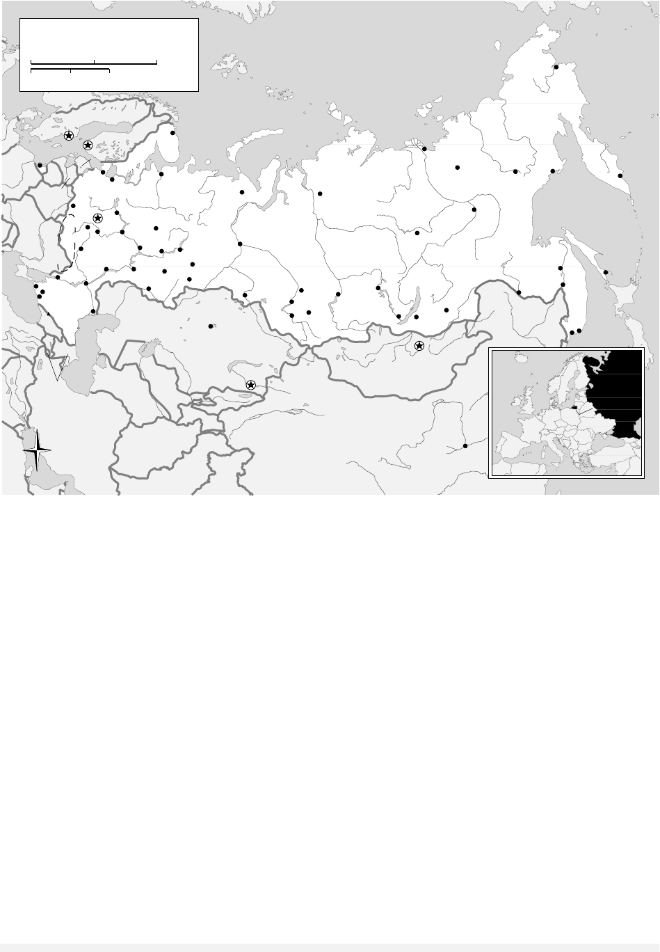
land, or steppe, the soils of which are Russia’s fer-
tile chernozems. Along the western and northern
shores of the Caspian Sea, desert replaces the grass-
lands. Farther south, North Caucasia merges with
the Greater Caucasus Mountains, the highest peak
of which is Mt. Elbrus (18,481 feet [5,633 meters]).
The northern part of the European Lowland
supports a northern coniferous forest, known as
taiga. The largest continuous stand of conifers in
the world, the taiga stretches from the Finnish bor-
der across Siberia and the Russian Far East to the
Pacific Ocean. Even farther north, flanking the Arc-
tic Ocean is the Russian tundra. Permafrost plagues
both the taiga and tundra, limiting their use for
anything other than logging and mineral develop-
ment. Soils are highly infertile podzols. Virtually
all of Siberia and the Russian Far East consist of ei-
ther taiga or tundra, except in the extreme south-
east, where temperate forest appears again.
East of the Urals is the West Siberian Lowland,
the world’s largest plain. The slow-moving Ob and
Irtysh rivers drain the lowland from south to
north. This orientation means that the lower
courses of the rivers are still frozen as the upper
portions thaw. The ice dam causes annual floods
that create the world’s largest swamp, the Vasyu-
gan. The Ob region contains Russia’s largest oil and
gas reservoirs. In southeastern Western Siberia is
Russia’s greatest coal field, the Kuzbas. South of
the Kuzbas are the mineral-rich Altai Mountains,
which together with the Sayan, and the Yablonovy
ranges, form the border between Russia, China, and
Mongolia.
East of the Yenisey River is the forested Central
Siberian Plateau, a broad, sparsely populated table-
land that merges farther east with the mountain
ranges of the Russian Far East. In the southeastern
corner of the plateau is a great rift valley in which
GEOGRAPHY
547
ENCYCLOPEDIA OF RUSSIAN HISTORY
Mt. Elbrus
18,510 ft.
5642 m.
C
A
U
C
A
S
U
S
M
T
S
.
ZAPADNO
SIBIRSKAYA
RAVNINA
REDNE
SIBIRSKOYE
PLOSKOGRYE
S
E
V
E
R
O
S
I
B
I
R
S
K
A
Y
A
N
I
Z
M
E
N
N
O
S
T
SIBERIA
Kol'skiy
Poluostrov
Severnaya
Zemlya
Poluostrov
Taymyr
Poluostrov
Kamchatka
Sakhalin
Komandorskiye
Ostrova
Wrangel I.
New
Siberian Is.
Gydanskiy
Poluostrov
Poluostrov
Yamal
Franz Josef
Land
U
R
A
L
M
O
U
N
T
A
I
N
S
Y
A
B
L
O
N
O
V
Y
Y
K
H
R
E
B
E
T
V
E
R
K
H
O
Y
A
N
S
K
K
H
R
E
B
E
T
S
T
A
N
O
V
O
Y
K
H
R
E
B
E
T
K
H
R
E
B
E
T
D
Z
H
U
G
D
Z
H
U
R
K
H
R
E
B
E
T
C
H
E
R
S
K
O
G
O
K
u
r
i
l
I
s
l
a
n
d
s
K
O
L
Y
M
A
M
T
S
.
K
O
R
Y
A
K
M
T
S
.
Black
Sea
ARCTIC OCEAN
PACIFIC
OCEAN
Bering
Sea
Barents Sea
Kara Sea
Baltic Sea
Laptev
Sea
Sea of Okhotsk
Bering Strait
East
Siberian
Sea
Chukchi
Sea
Anadyrskiy
Zaliv
T
a
t
a
r
P
r
o
l
i
v
Ozero
Baykal
A
m
u
r
O
b
'
O
b
'
I
r
t
y
s
h
L
e
n
a
L
e
n
a
V
i
l
y
u
y
A
n
g
a
r
a
K
o
l
y
m
a
I
n
d
i
g
i
r
k
a
A
l
d
a
n
O
l
e
n
e
k
D
o
n
Ladozhskoye Ozero
K
a
m
a
N
i
z
h
n
y
a
y
a
T
u
n
g
u
s
k
a
Y
e
n
i
s
e
y
V
o
l
g
a
U
r
a
l
Caspian
Sea
Orenburg
Tuapse
Novorossiysk
Smolensk
Saratov
Izhevsk
Verkhoyansk
Petropavlovsk
Kamchatskiy
Komsomol'sk
Chita
Ulan-
Ude
Bratsk
Blagoveshchensk
Anadyr'
Tiksi
Vorkuta
Kaliningrad
Kirov
Yaroslavl'
Magadan
Oymyakon
Astrakhan
Ryazan
Krasnodar
Khabarovsk
Irkutsk
Barnaul
Krasnoyarsk
Tomsk
Novokuznetsk
Noril'sk
Khanty
Manisysk
Yakutsk
Mirnyy
Vladivostok
Nakhodka
Korsakov
Xi'an
Tula
Voronezh
Murmansk
Arkhangel'sk
Syas'stroy
Rostov
Volgograd
Perm'
Yekaterinburg
Chelyabinsk
Qaraghandy
Kazan'
Samara
Ufa
Nizhniy Novgorod
Omsk
Novosibirsk
St.
Petersburg
Moscow
Ulan Bator
Alma Ata
Helsinki
Stockholm
ù
KARELIA
Kursk
Magnetic
Anomaly
CHINA
MONGOLIA
KAZAKHSTAN
TURKMENISTAN
UZBEKISTAN
AFGHANISTAN
PAKISTAN
INDIA
TAJIKISTAN
KYRGYZSTAN
IRAN
UKRAINE
AZERBAIJAN
ARMENIA
GEORGIA
BELARUS
LATVIA
LITHUANIA
FINLAND
ESTONIA
SWEDEN
JAPAN
Russia
W
S
N
E
RUSSIA
1000 Miles
0
0
1000 Kilometers
500
500
Russia, 1992 © M
ARYLAND
C
ARTOGRAPHICS
. R
EPRINTED WITH PERMISSION
.

lies Lake Baikal, “Russia’s Grand Canyon.” Equal to
Belgium in size, the world’s deepest lake gets deeper
with every earthquake.
See also: CLIMATE
BIBLIOGRAPHY
Lydolph, Paul E. (1990). Geography of the USSR. Elkhart
Lake, WI: Misty Valley Publishing.
Mote, Victor L. (1994). An Industrial Atlas of the Soviet
Successor States. Houston, TX: Industrial Informa-
tion Resources.
Mote, Victor L. (1998). Siberia Worlds Apart. Boulder, CO:
Westview.
Shaw, Denis J. B. (1999). Russia in the Modern World: A
New Geography. Malden, MA: Blackwell.
V
ICTOR
L. M
OTE
GEORGIA AND GEORGIANS
Georgia [Sak’art’velo] is among the “Newly Inde-
pendent States” to emerge from the collapse of the
Soviet Union. Its territory covers 69,700 square
kilometers, bordered by the North Caucasus re-
publics of the Russian Federation on the north,
Azerbaijan to the west, Armenia and Turkey to the
south and southwest, and the Black Sea to the east.
It includes three autonomous regions: Adjaria,
Abkhazia, and South Ossetia. The latter two have
maintained a quasi-independent status for most of
the post-Soviet period, and have been the scenes of
violence and civil war. The capital city of Tiflis, lo-
cated on the Mtkvari (or Kura) River in the heart
of Georgia, has a population of 1.2 million, ap-
proximately 22 percent of the republic’s 5.4 mil-
lion. Georgia’s head of state is a president. A
unicameral parliament is Georgia’s legislative body.
The Georgians are historically Orthodox Chris-
tians, with some conversions to Islam during times
of Muslim rule. Their language, with its own al-
phabet (thirty-three letters in the modern form), is
a member of the Kartvelian family, a group distinct
from neighboring Indo-European or Semitic lan-
guages. Speakers of Mingrelian and Svanetian, two
of the other Kartvelian languages, also consider
themselves Georgian. Laz, closely related to Min-
grelian, is spoken in Turkey. Georgia has an ethni-
cally diverse population: Georgian 70.1 percent,
Armenian 8.1 percent, Russian 6.3 percent, Azeri
5.7 percent, Ossetian 3 percent, Abkhaz 1.8 percent,
and other groups comprising 5 percent.
Georgian principalities and kingdoms began to
appear in the last few centuries of the first millen-
nium
B
.
C
.
E
, and existed alongside a well-traveled
east-west route on the peripheries of both Persian
and Greco-Roman civilizations. These influences
were mediated through their Armenian neighbors
who, with the Georgians, also maintained contacts
with Semitic cultures.
Ancient Georgian culture was split into two
major areas: east and west, divided by the Likhi
mountains. The eastern portion, known as Kartli,
or Iberia, had its center at Mtskheta, at the con-
fluence of the Aragvi and Mtkvari Rivers. When
not directly controlled by a Persian state, it still
maintained ties with the Iranian political and cul-
tural spheres. This connection lasted well into the
Christian period, when the local version of Zoroas-
trianism vied with Christianity.
Western Georgia was known by different
names, depending upon the historical source:
Colchis, Egrisi, Lazica. It had more direct ties with
Greek civilizations, as several Greek colonies had
existed along the Black Sea coast from as early as
the sixth century
B
.
C
.
E
. Western Georgia was even-
tually more directly under the control of the Ro-
man Empire, in its successive incarnations.
The conversion of the Kartli to Christianity oc-
curred in the fourth century as the Roman Empire
was beginning its own transition to Christianity.
As with other aspects of cultural life, Armenian and
Semitic sources were important. Mirian and his
royal family, after being converted by St. Nino, a
Cappadocian woman, made Christianity the offi-
cial religion. Dates in the 320s and 330s are argued
for this event. The conversion of the west Geor-
gians land owes itself more directly to Greek Chris-
tianity.
The conversion of the Georgians was accom-
panied by the invention of an alphabet in the early
fifth century. Scripture, liturgy, and theological
works were translated into Georgian. This associ-
ation of the written language with the sacred is a
vital aspect of Georgian culture.
The Georgian capital was transferred from Mt-
skheta to Tiflis in the fifth century, a process be-
gun during the reign of King Vakhtang, called
Gorgasali, and completed under his son Dachi.
Vakhtang is portrayed in Georgian sources, in an
GEORGIA AND GEORGIANS
548
ENCYCLOPEDIA OF RUSSIAN HISTORY

exaggerated fashion, as one of the important fig-
ures in transferring Kartli from an Iranian orien-
tation to a Byzantine one. This was a complex time
of struggle in the South Caucasus, not only be-
tween Byzantine and Persian Empires, but also
among various Armenian, Caucasian Albanian, and
Georgian states vying for power.
These currents of conflict were drastically al-
tered in the seventh century when Islam asserted
its military and political power. Tiflis was captured
by an Arab army in 645, a mere thirteen years af-
ter the death of Muhammad, and would remain
under Arab control until the time of David II/IV
(the numbering of the Bagratid rulers differs ac-
cording to one’s perspective) in the eleventh cen-
tury.
While Christianity was tolerated in Eastern
Georgia, the political center shifted westward, where
the Kingdom of Abkhazia grew to preeminence in
the eighth century. This realm was one of mixed
ethnic composition, including the Kartvelians of
West Georgia (i.e. the ancestors of today’s Min-
grelians and Svanetians) and, toward the north-
west, the ancestors of the Abkhazian people.
Meanwhile, a branch of the Bagratid family,
which had ruled parts of Armenia, and who were
clients of the Byzantine Empire, became prominent
in the Tao-Klarjeti region of southwest Georgia.
Because of Bagrat III (d. 1014), they became in-
heritors of the Kingdom of Abkhazia. From their
capital Kutaisi they contemplated the re-conquest
of Tiflis and the unification of Georgian lands. This
was accomplished in 1122 by David II/IV, called
the Builder, who reigned from 1089 to 1125. For
nearly two centuries, through the reign of Tamar
(1184–1212), the Georgians enjoyed a golden age,
GEORGIA AND GEORGIANS
549
ENCYCLOPEDIA OF RUSSIAN HISTORY
Georgian citizens wave flags and shout during an anti-government rally in Tiflis, May 26, 2001. © AFP/CORBIS

when they controlled a multiethnic territory from
the Black to the Caspian Seas and from the Cau-
casus Mountains in the north, toward the Ar-
menian plateau in the south. It was also a time of
great learning, with theological academies at
Gelati, near Kutaisi, and in the east at Iqalto on the
Kakhetian plain. The literary output of this time
reached it zenith with Shota Rustaveli’s epic tale
of heroism and chivalry, Knight in the Panther Skin,
written in the last quarter of twelfth century.
In the thirteenth century a succession of inva-
sions by Turks and Mongols brought chaos and
destruction upon the Georgians. These culminated
in the devastating raids of Timur in the early fif-
teenth century. From these depredations Georgian
society was very slow to recover, and for much of
the next four centuries it remained under the sway
of the Savafid Persian Empire and the Ottoman
Empire. Georgians at this time were active at the
Safavid court. The Bagratid dynasty continued to
reign locally over a collection of smaller states that
warred against one another. West European trav-
elers who ventured through Georgia in these cen-
turies give sad reports about the quality of life.
In the eighteenth century the Russian Empire’s
steady expansion brought it to the foothills of the
Caucasus Mountains and along the Caspian Sea to
the east of Georgia. Russians and Georgians had
been in contact through earlier exchanges of em-
bassies. Persian invasions in that century had been
especially harsh, and the Georgians looked to their
northern Orthodox neighbor for assistance. This
assistance culminated first in the 1783 Treaty of
Georgievsk, by which Irakle II’s realm of Kartli-
Kakheti became a protectorate of the Russian Em-
pire. Then, in 1801, soon after his accession to the
throne, Alexander I signed a manifesto proclaim-
ing Kartli-Kakheti to be fully incorporated into Rus-
GEORGIA AND GEORGIANS
550
ENCYCLOPEDIA OF RUSSIAN HISTORY
C
A
U
C
A
S
U
S
M
O
U
N
T
A
I
N
S
L
E
S
S
E
R
C
A
U
C
A
S
U
S
M
T
S
.
Mt. Shkhara
16,627 ft.
5068 m.
Black
Sea
R
i
o
n
i
E
ng
u
ri
K
u
r
a
A
l
a
z
a
n
i
I
o
r
i
C
o
r
u
h
T
e
r
e
k
Sevdna
Lich
Tskhinvali
T’bilisi
Yerevan
Rustavi
Sokhumi
Batumi
K’ut’aisi
Gudauta
Tkvarcheli
Jvari
Senaki
Akhaltsikhe
Samtredia
Chiat’ura
Gori
Lagodekhi
Tsnori
Patara Shiraki
Poti
Zugdidi
Gagra
Ochamchira
Kobuleti
Bolnisi
Bogdanovka
Shaumyani
Ozurgeti
Khashuri
T’elavi
T’ianet’l
Vladikavkaz
Malhachlala
Nal’chik
Pyatigorsk
Armavir
Stavropol’
Nevinnomyssk
Borzhomi
Zestafoni
Ardahan
Kumayri
Kirovakan
Kirvovabad
Shäki
ABKHAZIA
AJARIA
SOUTH
OSSETIA
TURKEY
RUSSIA
ARMENIA
AZERBAIJAN
W
S
N
E
Georgia
GEORGIA
100 Miles
0
0
100 Kilometers
50
50
Georgia, 1992 © M
ARYLAND
C
ARTOGRAPHICS
. R
EPRINTED WITH PERMISSION
.

sia. Other parts of Georgia followed within the next
decade, although not always willingly.
Despite Russification efforts during the nine-
teenth century, the Georgian language and culture
underwent a renaissance that would undergird
Georgian national aspirations in the twentieth cen-
tury. The Society for the Spread of Literacy among
the Georgians, founded by Iakob Gogebashvili, was
important for fostering language acquisition, es-
pecially among children. Ilia Chavchavadze, Akaki
Tsereteli, and Vazha Pshavela dominated the liter-
ary scene into the twentieth century.
Georgians joined with comrades throughout
the Russian Empire in the revolutions of 1905 and
1917. When the Russian state began to shed its pe-
riphery in 1918, the Georgians briefly entered the
Transcaucasian Republic. This political entity lasted
from February until May 1918, but then split into
its constituent parts. Georgia proclaimed its inde-
pendence on May 26, 1918. The Democratic Re-
public of Georgia, beset by internal and external
enemies, lasted less than three years, and on Feb-
ruary 26, 1921, the Bolsheviks established Soviet
power in Tiflis. Independent Georgia had been gov-
erned mainly by Mensheviks, an offshoot of the
Russian Social Democratic Workers’ Party. They
were reluctant nationalists, led by Noe Zhordania,
who served as president. These Mensheviks became
the demonic foil for any number of aspects of Soviet
historiography and remained so for the Abkhazians
when they would press for greater autonomy.
The Soviet Socialist Republic of Georgia entered
the USSR through the Transcaucasian Soviet Fed-
erative Socialist Republic in 1922 and remained a
member of it until its dissolution in 1936. After-
ward the Georgian Soviet Socialist Republic became
one of the USSR’s constituent republics. Three au-
tonomous regions were created within Georgia,
part of what some describe as a manifestation of
the “divide and conquer” regime of ethnic pseudo-
sovereignties. The South Ossetian Autonomous
Oblast was established across the border from
North Ossetia, and the Adjar A.S.S.R. was an en-
clave of historically Muslim Georgians in the
southwest. The third, and most troubled, part of
Georgia was Abkhazia. This region in the north-
west along the Black Sea coast had been in an am-
biguous federative, treaty status with Georgia, but
was finally, in 1931, incorporated as an A.S.S.R.
Georgia fared generally no better or worse for
having its “favorite son,” Iosep Jugashvili (a.k.a.
Josef Stalin), as the dictator of the Soviet Union.
With other parts of the U.S.S.R., it suffered the
depredations of party purges and the destruction
of its national intelligentsia in the 1930s.
In the latter decades of the Soviet period, Geor-
gia was held up as a sort of paradise within the
Soviet system. Agriculture, with tea and citrus in
the subtropical zone in the west, prospered, and the
Black Sea coast was a favorite spot for vacationers
from the cold north. The hospitality of the Geor-
gians, seemingly uncooled by Soviet power, and al-
ways warmed by the quality of Georgia’s famous
wines, wooed Soviet and foreign guests alike.
The Georgians developed a vigorous dissident
movement in the 1970s, with Zviad Gamsakhur-
dia and Merab Kostava playing leading roles. Tens
of thousands came out into the streets of Tiflis in
1978 to protest the exclusion of the Georgian lan-
guage from the new proposed Constitution of the
Georgian S.S.R.
As Gorbachev’s glasnost worked its effects, the
Georgian independence movement gave rise to com-
peting movements in South Ossetia and Abkhazia.
In reaction to a communiqué issued by Abkhazian
intellectuals in March 1989, the main streets of
Tiflis again overflowed with protesters. On the
morning of April 9, 1989, troops moved against
the demonstration, killing at least twenty and in-
juring scores of others. This outburst of violence
marked the beginning of the rapid devolution of
Soviet power in Georgia.
Georgia voted for its independence on April 9,
1991, and elected its first president, Zviad Gam-
sakhurdia, in May. His rule was harsh, and his
presidency barely survived the final collapse of the
USSR by a few months into 1992. Eduard She-
vardnadze, who had held power in Georgia under
Communist rule, and who became Gorbachev’s for-
eign minister, returned to Georgia, eventually to be
elected twice to the presidency. His presidency was
plagued by warfare and continuing conflict in
South Ossetia and Abkhazia, both of which claimed
independence. The ethnic conflict compounded the
economic dislocations, although the proposed
Baku-Tiflis-Ceyhan oil pipeline, the beginning of an
east-west energy corridor, has brought the promise
of some future prosperity.
See also: CAUCASUS; NATIONALITIES POLICIES, SOVIET;
NATIONALITIES POLICIES, TSARIST; SHEVARDNADZE,
EDUARD AMVROSIEVICH
GEORGIA AND GEORGIANS
551
ENCYCLOPEDIA OF RUSSIAN HISTORY

BIBLIOGRAPHY
Allen, W. E. D. (1971). A History of the Georgian People:
From the Beginning down to the Russian Conquest in
the Nineteenth Century. New York: Barnes & Noble.
Aronson, Howard. (1990). Georgian: A Reading Grammar,
2nd ed. Columbus, OH: Slavica..
Braund, David. (1994). Georgia in Antiquity: A History of
Colchis and Transcaucasian Iberia, 550
BC
–
AD
562. Ox-
ford: Clarendon.
Lang, David Marshall. (1962). A Modern History of Soviet
Georgia. New York: Grove.
Rapp, Stephen H., Jr. (1997). “Imagining History at the
Crossroads: Persia, Byzantium, and the Architects of
the Written Georgian Past.” Ph.D. diss, University
of Michigan. Ann Arbor.
Suny, Ronald G. (1994). The Making of the Georgian Na-
tion, 2nd ed. Bloomington: Indiana University Press.
Toumanoff, Cyril. (1982). History of Christian Caucasia.
Washington, DC: Georgetown University Press.
P
AUL
C
REGO
GEORGIAN ORTHODOX CHURCH
The Orthodox Church of Georgia, an autocephalous
church of the Byzantine rite Eastern Churches, is
an ancient community. It dates from the fourth
century, and stories of the evangelization of Kartli
center around St. Nino, called Equal to the Apos-
tles, who was born in Cappadocia, studied in
Jerusalem, and made her way through Armenia to
preach, heal, baptize, and convert the Georgian peo-
ple. Later traditions add apostolic visits from St.
Andrew and St. Simeon the Canaanite that reflect
evangelization of western Georgia. Christians in
Kartli continued to have a strong relationship with
the Armenians until the seventh century, when
these Christian people opted for different Chris-
tologies.
The autocephaly of the Orthodox Church is
claimed from the fifth century, when the Arch-
bishop of Mtskheta was given the title of Catholi-
cos. There was later also a Catholicos in western
Georgia, coinciding with the Kingdom of Abkhazia.
Western Georgia was evangelized more directly
by Greeks, and, after the split from the Armenians,
the entire Georgian Church strengthened its ties
with the church in Constantinople. Of the family
of Orthodox Churches that derive their liturgies
from the Byzantine tradition, the liturgical lan-
guage remains an archaic Georgian, not entirely in-
telligible to modern speakers.
The Georgians, for much of their history, have
lived under the rule of Muslim states. Arab Mus-
lims conquered Tiflis in 645, and it continued un-
der Muslim rule until 1122. After a brief golden
age the Georgians again came under Muslim con-
trol, alternating between Savifid Persians and Ot-
toman Turks. The church endured this period of
time with difficulty and looked for assistance from
their Orthodox neighbors in Russia toward the end
of the eighteenth century. The identification of the
Georgian nation with its Orthodox identity was
strengthened in this period, as the church was of-
ten the guarantor of linguistic and national iden-
tity and the legal authority for the nation.
Soon after the Russians annexed Georgia (1801),
the autocephaly of the Georgian Church was re-
scinded (1811) and it became a part of the Russian
Orthodox Church. The Georgian Church became
one of the institutions in Georgia through which
the imperial government attempted its program of
Russification.
The Georgian Church reclaimed its autocephaly
in 1918, as Georgia was proclaiming its indepen-
dence. This short period of breathing space was
quickly constricted with the imposition of Soviet
power, and nearly seven decades of atheist educa-
tion and oppression took a devastating toll on the
Georgian Church. As in the rest of the USSR, church
buildings were closed, confiscated for other pur-
poses, left to ruin, or destroyed. The role of the
clergy was restricted, and many came under sus-
picion as possible KGB agents.
The reign of Catholicos-Patriarch Ilia II from
December 1977 marked a new beginning in the life
of the Georgian Church. Slowly, Ilia began to re-
store episcopal sees and reopen churches. In Octo-
ber 1988, the Tiflis Theological Academy was
opened. With the changes of perestroika and glas-
nost and the collapse of the Soviet Union, the Geor-
gian Church continued a dramatic revival. By the
end of the 1990s dozens of churches had been re-
built and many new ones built.
During the first decade of Georgia’s new inde-
pendence the church struggled to find its place in
society and in relation to the state. Georgian politi-
cians, especially the first president Zviad Gam-
sakhurdia, have used and misused their ties to the
church. The new Georgian Constitution not only
guarantees freedom of religion and conscience but
gives the church a place of historical honor. This
place of honor was given further definition and
practical meaning by a Concordat signed by the
government and the church on October 14, 2002.
GEORGIAN ORTHODOX CHURCH
552
ENCYCLOPEDIA OF RUSSIAN HISTORY