McKinney M. History and Politics in French-Language Comics and Graphic Novels
Подождите немного. Документ загружается.

124
Fabrice Leroy
chosen aides. The end of the story reveals that Radisic even intended to offer
his niece in marriage to De Cremer, to consolidate the link between their two
well-respected families (De Cremer’s great-uncle is alluded to several times
in the narrative as a man of reputation and importance). On the other hand,
De Cremer’s belief in the cartographic mimesis obtained through Djunov’s
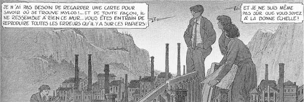
methods is undermined by the apparent inadequacy of their results (figure 2).
Indeed, when the center’s workers attempt to recreate miniature versions of
computer-imaged cities and landscapes, De Cremer appears unable to recon-
cile the resulting models with his own experience of their ontological refer-
ent, as if the geographic signifiers had been distorted beyond his recognition
(2: 21–23; figure 5).
Such a play on the trahison des images [betrayal of images]—Peeters is an
avowed Magritte admirer—is reflexive on many levels. First, the creation of
models duplicates the imaging process in a self-referential, tautological loop:
computer tracing reproduces reality; its reproduction is itself reproduced in
the shape of models (2: 21). A model is an image of an image; it is twice
removed from empirical reality—which, in this graphic novel, is itself but
another image. Secondly, the entire fictional device is clearly put en abyme
in the scenes (1: 48–49; 2: 20–23) where the story’s characters walk through a
miniature re-creation of their surroundings, as the fictional backdrop literally
becomes a cardboard theater set. As a representation within the representa-
tion, such a distanciation device leads the reader to question the ontological
existence of diegetic reality, as if the phenomenological “pour soi” [for itself]
of the representation negated the “en soi” [in itself] of any referent. Other
works by Schuiten and Peeters similarly play on models, miniatures, and
other trompe-l’œil effects of scenery and simulacres [simulacra]. One remem-
bers that in the first book of “Les cités obscures,” Les murailles de Samaris
Fig. 5. de cremer’s problem with models (La frontière invisible, vol. 2, p. 21) © schuiten-peeters /
casterman.
125
Schuiten and Peeters’s La frontière invisible
[The Walls of Samaris] (Schuiten and Peeters 1988), Franz Bauer explores a
city made entirely of two-dimensional panels that move around him and give
him the illusion of reality, until he steps behind the machinery and realizes
that the city itself is merely an image, one that is its own ontological reality.
The mimetic connection between image and referent, copy and model, is
often deconstructed in similar ways in other books, such as Dolorès (written
by Schuiten and Peeters in collaboration with Anne Baltus, 1993), a story in
which a model-maker changes dimensions and joins the miniature world of
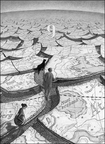
his creations. One can find similar reflexive and self-distanciating scenes in La
frontière invisible, particularly in the chapter-dividing illustrations that show
characters living inside a map, walking among the highly codified signifiers of
cartographic representation as if they were reality itself (e.g., 2: 51; figure 6).
Thirdly, such recurrent blurring of the line between image and reality,
which undoubtedly plays on what Philippe Lejeune calls our “postmodern on-
tological doubt,” also relies on consistent meta-narrative strategies. As various
commentators have noted, the “Cités obscures” offer various reflexive images
of themselves, both within the series itself (characters investigate the cities’
Fig. 6. lost in the real world (La frontière invisible, vol. 2,
p. 51) © schuiten-peeters / casterman.
126
Fabrice Leroy
existence; newspapers discuss their events; archivists catalog their objects),
and through corollary multimedia activities from their authors (documen-
taries, conferences, paintings, music). Such systematic reflexive commentary
fulfills two opposite functions. One, as Benoît Peeters himself noted, can be
described as a strategy of self-validation or self-reference: the invisible cit-
ies assert their own existence through an internal and external network of
meta-discourse that alludes to their existence outside of the two-dimensional
graphic realm. The opposite effect, of equal importance but more subtle, is
to cast a permanent doubt over their existence, precisely because it is only
attested to by discourse, distant echoes, and not firsthand experience of the
readers—although several readers have recently begun to participate in this
complex representational game by presenting themselves as dwellers of this
parallel universe, as characters, or merely visitors (Peeters 2005: 151–54). If,
according to Todorov’s (1976: 30–37) much debated definition, the fantas-
tique is by essence the genre of hesitation, one could argue that it is a form of
referential hesitation or ambivalence that constitutes the central fantastique
device in the “Cités obscures.”
Maps, of course, are to be understood within such a system of reflexive
ambivalence. The cities, which are merely image, offer a meta-image of them-
selves (maps), which at the same time authenticates and calls into question
their existence. Interestingly, the second volume of La frontière invisible came
with a double-sided ancillary map issued by the Institut Géographique Na-
tional (IGN) [National Geographic Institute], a genuine French geographic
society (see www.ign.fr), some of whose maps of other sites and countries
(“Niger,” “Lombardie,” “Amsterdam”) are also listed on a flap of this “physical
map [of] Sodrovno-Voldachia.” By inscribing the map of their fictional terri-
tory within a serialized format usually reserved for real-life locations (wittily
described on the map’s own para-text as “un univers plus terre à terre” [a
more down-to-earth universe] than the invisible cities, whose actual earthly
presence is uncertain), Schuiten and Peeters continue to play on the same
principle of referential illusion and meta-discursive validation that governed
their project from the start: to convince the reader that what is discussed in
overlapping sources must de facto exist (and doing so by borrowing the sym-
bolic credit of legitimate discourses, in this case that of an official mapping
institute). Furthermore, on one side of the map, they also provide an iconic
representation of the respective positioning of the invisible cities, finally re-
moving the reader’s blinders and allowing him or her a global, overhang-
ing view of a world only previously accessible through separate fragments,
because each book had been devoted to a restricted portion of this universe
127
Schuiten and Peeters’s La frontière invisible
(such as Urbicande, Xhystos, Samaris, Brüsel, Pâhry). This iconic perspec-
tive fits within a network of clues about the geopolitical system of the “Cités
obscures”:
Pour la page de titre [du premier album, Les murailles de Samaris], nous avons
realisé la page que Franz arrache au grand livre de Samaris, et sur laquelle on
peut lire: “Autour de Samaris sont huit grandes cités.” C’est alors que nous nous
sommes posé pour la première fois la question de l’emplacement de ces cités.
Qu’y a-t-il autour de Samaris et de Xhystos? Comment ce monde fonctionne-
t-il? etc. (Peeters in Jans and Douvry 2002: 37). [For the title page [of the first
book, The Walls of Samaris], we created the page that Franz tears from the great
book of Samaris, on which one can read: “Around Samaris are eight large cit-
ies.” This is when we asked ourselves for the first time the question of these
cities’ location. What is around Samaris and Xhystos? How does this world
function? etc.]
Such global positioning of the cities is, in Plato’s sense, a political endeavor in
itself, as John Sallis (1999: 139) reminds us: “Discourse on the city [polis] will
at some point or other be compelled, of necessity, to make reference to the
earth; at some point or other it will have to tell of the place on earth where
the city is—or is to be—established and to tell how the constitution (politeia)
of the city both determines and is determined by this location.” Schuiten and
Peeters’s “fake” map of the invisible cities relies on our geographic proficiency
as readers and users of real maps. Although it turns our spatial knowledge up-
side down—as it challenges the standard representations by which we make
sense of the world, like Arno Peters’s famously subversive map (Crampton
2002: 17)—it forces us at the same time to process our understanding of it
by filtering its signifiers through other geographic signifiers, whose shapes
and attached signification we have learned to recognize in our own experi-
ence of world maps, as if we were translating one language into another by
resemblance and inference. Assuming that the reader’s average geographic
awareness allows him or her a mental picture of a standard world map, like
the IGN’s own Carte du monde politique [Map of the Political World], he or
she is necessarily led by his or her cognitive predisposition to identify recog-
nizable elements, laid out in what appears as a jumbled order. For instance, he
or she may equate the triangular shape of the Urbicande peninsula with that
of India, or the contours of Mont Analogue’s island with those of Madagas-
car, although their scale, their orientation, and their relative positions cause
him or her to permanently doubt such identifications. The peninsula that
128
Fabrice Leroy
contains the city of Samaris resembles both Thailand and Florida; the Chu-
lae Vistae Islands evoke the shape of Cuba, Japan, or New Zealand. Brüsel is
situated in a territory whose shape clearly reminds us of Belgium, but it is
located northwest of Pâhry (an obvious homophone of Paris), itself placed
at the edge of a desert. Although it fulfills a long-standing desire for a more
global perspective on this mysterious world, the map of the “Cités obscures,”
because it recalls and distorts at the same time previous intertextual or inter-
pictural representations, produces therefore an inherently disorienting effect,
and does not in fact lift any mystery from this alternate world.
At the top of Schuiten and Peeters’s map, one finds the mention: “Une
des premières cartes réellement fiables des cités obscures. Ayant été établie
par les géographes de Pâhry, elle privilégie le côté ouest du continent.” [One
of the first truly dependable maps of the invisible cities. Having been drawn
by the geographers of Pâhry, it focuses mostly on the western side of the
continent.] This caption is worth examining in several regards. “Une des pre-
mières cartes” suggests that there are other maps, which confirms the exis-
tence of this world, since it is attested to in several unconnected testimonies
and documents. It also gives this particular map a special value, as a unique,
rare document, like a mythical treasure map: because the other maps have
disappeared or are not available for our perusal, we should treat this one as
a valuable archive, a miraculous hapax that we should feel lucky to have had
preserved. “Premières” may also account for the style of the map, which ap-
pears somewhat old- fashioned in comparison with the IGN Carte du monde
politique, for instance. It may simply be an “early” map that uses different
representational codes than our contemporary ones. Epistemologically, it
belongs to a different time than ours, the alternate time of the invisible cit-
ies, this retro-futuristic parallel world that resembles Jules Verne’s fictions, a
nineteenth-century world that projects itself into the future.
“Réellement fiables” seems equally problematic, as it paradoxically brings
into question the accurateness and the dependability of the map: if the map is
indeed truly reliable, why does it have to state its reliability with such redun-
dancy, by labeling itself as such and by resorting to an adverb of intensity?
Who is making this statement? Finally, the map is identified as the result of
the subjective focus of its enunciators, the geographers of Pâhry. Indeed, it
places Pâhry in the relative center of the known world, as though the latter
revolved around this city, just as the city revolves around the king’s palace in
Gomboust’s map (interestingly, the IGN is a Parisian institute, located on the
rue de Grenelle). Would the Sodrovno-Voldachian cartographers of La fron-
tière invisible have produced the same map, or would their imaging of reality
129
Schuiten and Peeters’s La frontière invisible
have differed as the result of an alternative political or epistemological point
of view, a radically different pour-soi [for-self]? As Jeremy Crampton (2002:
15–16) reminds us, cartographic inquiry is always subject to Gunnar Olsson’s
“fisherman problem”: “The fisherman’s catch furnishes more information
about the meshes of his net than about the swarming reality that dwells below
the surface.” In other words, the fisherman’s conjecture about the contents of
the sea is necessarily related and limited to the size and shape of his fishing
net. The iconic representation displayed in the Pâhrysian geographers’ map
is not physical reality, but their image of it, shaped by their sociocultural con-
ventions and agenda: to paraphrase Magritte, “ceci n’est pas un continent.”
By exceeding the representational limitations of metonymic tracing, which
presuppose a static and fixed object, maps are, as Deleuze and Guattari (1980:
20) have contended, open constructs:
Si la carte s’oppose au calque, c’est qu’elle est toute entière tournée vers une
expérimentation en prise sur le réel. La carte ne reproduit pas un inconscient
fermé sur lui-même, elle le construit. . . . Elle fait elle-même partie du rhizome.
La carte est ouverte, elle est connectable dans toutes ses dimensions, démont-
able, renversable, susceptible de recevoir constamment des modifications. Elle
peut être déchirée, renversée, s’adapter à des montages de toute nature, être
mise en chantier par un individu, un groupe, une formation sociale. On peut
la dessiner sur un mur, la concevoir comme une œuvre d’art, la construire
comme une action politique ou une méditation. C’est peut-être un des carac-
tères les plus importants du rhizome, d’être toujours à entrées multiples. [What
distinguishes the map from the tracing is that it is entirely oriented toward
an experimentation in contact with the real. The map does not reproduce an
unconscious closed in upon itself; it constructs the unconscious. . . . It is itself
part of the rhizome. The map is open and connectable in all of its dimensions;
it is detachable, reversible, susceptible to constant modification. It can be torn,
reversed, adapted to any kind of mounting, reworked by an individual, group,
or social formation. It can be drawn on a wall, conceived as a work of art, con-
structed as a political action or as a meditation. Perhaps one of the most im-
portant characteristics of the rhizome is that it always has multiple entryways.]
(Trans. Brian Massumi, A Thousand Plateaus, 1987: 12)
Furthermore, one could easily argue that the “fisherman’s problem” affects all
representations of the obscure cities, because the various discourses or images
through which the reader gains access to glimpses of this parallel universe re-
main similarly problematic. Frédéric Kaplan (1-23-05: 14–15) has gone so far
130
Fabrice Leroy
as to liken the problem of objective reality in Schuiten and Peeters’s series to
the principles of quantum physics, which famously postulate that objects ex-
ist only through the contextual act of measurement, but not outside of it.
By contrast, the other side of Schuiten and Peeters’s map, which de-
picts the country of Sodrovno-Voldachia, is openly political, in the mold of
Jacques Gomboust’s portrayal of the Sun King’s absolute power, mirrored in
the map of Paris. This is, we assume, the map that Radisic commissioned (1:
60–61), or one similar to it. In pure “Ancien Régime” [Old Regime] fashion, it
is imprinted with a heraldic seal of political power—a large blazon in the up-
per right-hand corner that contains a strong deictic assertion of legitimacy:
two winged dragons on each side of a crown, above the inscription “Terre et
Loi” [Land and Law], a formula which mirrors Marin’s (1981: 11) observation
that representation not only signifies power (translates it into signs), but also
“signifies force in the discourse of the law.” This map speaks of conquest
and territorial claims, because it contains a “frontière contestée” [contested
frontier] between Sodrovni and Mylos, another “frontière non délimitée”
[undelimited frontier], a “zone neutre” [neutral zone] above Muhka, various
“zones revendiquées” [claimed zones] or “zones annexées” [annexed zones],
as well as fragments of a dividing wall and sections of trenches between the
northwestern and the southwestern parts of the map. To the extent that it
attempts to capture political flux and to stake dubious political claims, the
map paradoxically represents nothing; it is an ever-changing palimpsest, a
text whose imprinted signifiers are subject to being relabeled according to
military conquest, and betray a doubt as to their very permanence (“zone
d’incertitude” [zone of uncertainty], etc.). Besides, the map is accompanied
by an amusing disclaimer at the bottom, which speaks of the fear of power
within those in charge of political representation:
Le tracé des frontières n’a pas de valeur juridique. Les informations portées
sur cette carte ont un caractère indicatif et n’engagent pas la responsabilité de
l’IGN. Les utilisateurs sont priés de faire connaître à l’Archiviste les erreurs
ou omissions qu’ils auraient pu constater. [The drawing of the frontiers has
no legal value. The information included in this map is only of an indicative
nature and does not bind the IGN to any responsibility. The users are asked to
kindly communicate to the Archivist the mistakes or omissions that they may
have noticed.]
It all goes back to Marin’s (1981: 12–13) clever paradox: power, because it relies
on the symbolic transformation of physical force into discourse, is also pow-
131
Schuiten and Peeters’s La frontière invisible
erlessness. The language of conjecture and uncertainty, on the part of the
mappers themselves, speaks of the discomfort of their positions as subjects
to power, but also opens discursive gaps that undo their own absolutist con-
struct: this is what the country is or should be, but we are not “responsible”
or accountable for the potential mistakes of our representation (do not use
against us the force that we are to symbolically convey), in which case power
negates itself. The request to communicate mistakes to the Archivist con-
nects this story with another meta-narrative endeavor within the series (see
the volume entitled L’archiviste [The Archivist], Schuiten and Peeters 2000)
and encourages, as always, the interactive cooperation of the readers. On the
subject of representation as palimpsest, another telling image can be found
in the first volume of La frontière invisible: a panel in which De Cremer is
depicted standing in front of the Cartography Center’s giant dome (1: 10),
whose external gates or loading docks have been renumbered or relabeled
several times according to different codes (e.g., N 15, ZA 12, LN 103), as if
to indicate that the very producer of representation is itself subject to the
conceptual instability of naming or renaming. Finally, the “Cités obscures”
offer us a map of their mysterious realm, but it is a map that reveals the im-
possibility of mapping.
If the map of Sodrovno-Voldachia is of any practical use for the reader,
it is in conjunction with the travel narrative told in La frontière invisible, be-
cause it allows us to partially visualize the itinerary of De Cremer from the
moment when he flees the Cartography Center. This journey is itself vague,
as we often cannot match the landscapes depicted in the panels with their
more abstract, larger scale cartographic equivalents. However, the map’s un-
explored spaces hint at subsequent adventures in the world of the “Cités
obscures”: what goes on in the “Grande Déchetterie de Rovignes” [Great
Landfill of Rovignes], in the “Réserve Biologique des Deslioures” [Biological
Reserve of the Deslioures], or in the “Zone de Silence du Désert de Char-
treuse” [Zone of Silence of the Chartreuse Desert]? These are arguably, in
Genette’s (1971: 112–14) terminology, amorces [hints] of future developments
in the series.
As De Cremer becomes increasingly conscious of the arbitrary nature
of the cartographic signifying process, and of the gaps between maps and
their ontological referent, he meets an attractive young prostitute, Shkodrã,
who brings yet another reflexive layer to his iconological confusion. Schuiten
and Peeters have exploited in various other books the narrative pattern of a
male héros célibataire [unmarried hero] encountering a mysterious and entic-
ing female figure on his path to change or revelation (for example, La fièvre
132
Fabrice Leroy
d’Urbicande [Fever in Urbicand],or Brüsel). De Cremer, who reluctantly en-
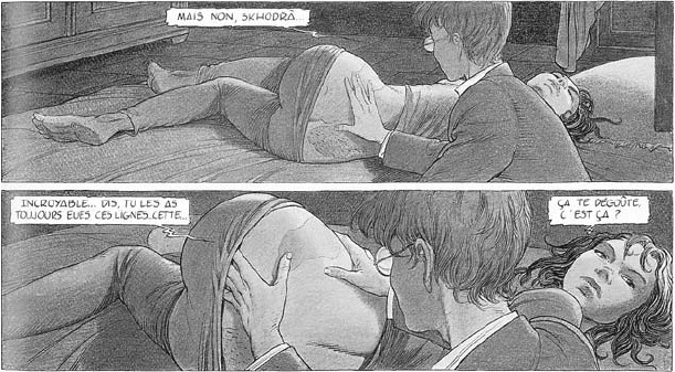
ters a brothel at Djunov’s initiative, discovers that Shkodrã refuses to appear
half-naked in public as the other prostitutes do, probably to hide a strange
birthmark on her backside that reminds him of one of Cicéri’s old maps, a
subversive document that contradicts Radisic’s image of the State (figure 7).
Although the young man is irresistibly attracted by the prostitute’s sexual
availability,—his map fetish playing, undoubtedly, an important part in his
attraction—De Cremer begins to fear for the safety of the young woman and
improvises an escape with her.
Shkodrã (1: 34, 44–46) is an interesting figure in several regards. As a
prostitute, she is an archetypal subaltern and a suitable equivalent of the ter-
ritory to be mapped: she is who her client wants her to be—she is an object
to name and possess. Indeed, we learn that Shkodrã is in fact the name of the
village where she was born, a place that has been destroyed by border dis-
putes and the subsequent building of a wall to divide the countries at war (2:
48). Left nameless, Shkodrã was renamed with the signifier of her birthplace,
like many subalterns in history, such as slaves or immigrants. But Shkodrã,
like the land to be mapped, equally escapes possession. Charles Bernheimer
(1989), in his excellent essay on the representation of prostitution in the
nineteenth-century French novel, clearly shows that the prostitute is a much
more complex figure than she first appears to be, and that her control and
possession only reveal that she ultimately escapes control. She is an agent of
dispossession: indeed, the selfish male use of her sexuality and the pleasure it
Fig. 7. shkodrã’s body as a map (La frontière invisible, vol. 1, p. 45) © schuiten-peeters / casterman.
133
Schuiten and Peeters’s La frontière invisible
provides are only temporary, leaving him dispossessed and used in the face of
an autonomous and subversive sexual being. Attempted control of the pros-
titute is a castrating, not an empowering, act. Although De Cremer’s feelings
for Shkodrã clearly go beyond sexual lust, the possession of her will prove just
as elusive as that of the territory.
Shkodrã is also the bearer of a map-like image, and, as such, reverses the
entire paradigm of representation. Maps are normally man-made objects that
attempt to present a codified image of ontological reality. They function as
metaphorical substitutes (founded by mimetic resemblance with their ob-
jects) and metonymic transfers (as their existence only duplicates that of the
object that they trace). But they remain essentially images: “a map is not the
territory it represents” (Crampton 2002: 18) but its iconic equivalent, which
reminds us again of Magritte’s well-known anti-mimetic principle, “Ceci n’est
pas une pipe” [This is not a pipe]. Yet Shkodrã, the ultimate reflexive device, is
an ontological being, whose body mirrors a man-made epistemological con-
struct, a map. Reality copies an image, life imitates art: as his methodological
grasp on the world begins to fail him, De Cremer can only run away aimlessly
and ponder various ontological questions. Is the image on Shkodrã’s body a
mere coincidence, the simple projection of his cartographic imagination, or
instead the embodiment of Radisic’s rhetoric on “natural” borders (1: 56–58,
2: 20)? Since it contradicts Radisic’s imperialistic plans and the state’s official
vision, is it more or less true than the official political truth? Can reality con-
tradict discourse? Can image be ontological? Can bodies be representations,
and vice versa? And if so, can body signifiers be subversive per se: can they be
deemed antipolitical in the unfortunate eventuality that their natural appear-
ance does not match the state’s discourse?
As the army takes control of the Cartography Center, and begins to arrest
its administrators, causing a wave of Kaf kaesque paranoia among its employ-
ees (2: 34–38), De Cremer and Shkodrã escape by boarding a one-wheel vessel
(created by Axel Wappendorf, a famous inventor of the obscure world who
appears in other volumes of the series) en route to Galatograd, the state’s
capital. In the meantime, fearing for their respective careers, Cicéri and Dju-
nov denounce De Cremer’s subversive relationship with Shkodrã to Colonel
Saint-Arnaud, the new military administrator of the center. Djunov accuses
the young cartographer of plotting against the government by using Shko-
drã’s body markings as a “weapon” against Radisic’s political agenda—“De
Cremer veut l’utiliser comme une arme contre la grande Sodrovnie” (2: 41)
[De Cremer wants to use her as a weapon against the great Sodrovnia]—,
which is far from his true intentions. Cicéri’s motives for denunciation