Seybold J.S. Introduction to RF Propagation
Подождите немного. Документ загружается.

h
m
is the height of the mobile antenna
d is the propagation distance
b=(40/f )
2
, where f is in MHz
Note that the Egli model provides the entire path loss, whereas the foliage
models discussed earlier provided the loss in addition to free-space loss. Also
note that the Egli model is for irregular terrain and does not address vegeta-
tion. While similar to the ground-bounce loss formula, the Egli model is not
based on the same physics, but rather is an empirical match to measured data
[4]. By assuming a log-normal distribution of terrain height, Egli generated a
family of curves showing the terrain factor or adjustment to the median path
loss for the desired fade probability [6]. This way the analyst can determine
the mean or median signal level at a given percentage of locations on the circle
of radius d. Stated another way, the Egli model provides the median path loss
due to terrain loss. If a terrain loss point other than the median (50%) is
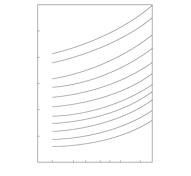
desired, the adjustment factor in dB can be inferred from Figure 7.6.
Example 7.2. Determine the median terrain loss for a 1-km link operating at
100 MHz if the antenna heights are 20 m and 3 m, using the Egli model for
terrain loss.
142 NEAR-EARTH PROPAGATION MODELS
+20
+15
+10
+5
–5
–10
–15
–20
–25
–30
40 50 60 80 100 150 200 300 500
1000
0
99
95
90
80
70
60
Median–50
40
30
20
10
Percent of
locations
Terrain factor, dB
99.9
Frequency (MHz)
5
Figure 7.6 Terrain factor versus frequency for different probabilities for the Egli
model. (Figure 3.20 from Ref. 4, courtesy of Wiley.)

Applying equation (7.9),
and thus
If the 90th percentile is desired (i.e., the level of terrain loss that will be
exceeded 10% of the time), approximately 10 dB would be added to the L
50
value according to Figure 7.6, so
䊐
The Egli model provides a nice, closed-form way to model terrain effects, but
since it is a one-size-fits-all model, it should not be expected to provide precise
results in all situations. For detailed planning, there are software packages
available that use DTED (Digitized Terrain Elevation Data) or similar terrain
data and model the expected diffraction loss on a given path. Such models are
ideal for planning fixed links, but are of limited utility for mobile links. One
exception is the Longley-Rice model, which provides both point-to-point and
area terrain loss predictions.
7.3.2 Longley–Rice Model
The Longley–Rice model is a very detailed model that was developed in the
1960s and has been refined over the years [8–10]. The model is based on data
collected between 40 MHz and 100 GHz, at ranges from 1 to 2000 km, at
antenna heights between 0.5 and 3000 m, and for both vertical and horizontal
polarization. The model accounts for terrain, climate, and subsoil conditions
and ground curvature. Blaunstein [8] provides a detailed description of the
model, while Parsons [9] provides details determining the inputs to the model.
Because of the level of detail in the model, it is generally applied in the form
of a computer program that accepts the required parameters and computes
the expected path loss. At the time of this writing, the U.S. National Telecom-
munications and Information Administration (NTIA) provides one such
program on its website [11] free of charge. Many commercial simulation prod-
ucts include the Longley–Rice model for their terrain modeling. As indicated
in the previous section, the Longley–Rice model has two modes, point-to-point
and area. The point-to-point mode makes use of detailed terrain data or char-
acteristics to predict the path loss, whereas the area mode uses general infor-
mation about the terrain characteristics to predict the path loss.
L
90
dB= 122 2.
L
50
dB= 112 4.
L
50
=-
◊
◊
()
Ê
Ë
ˆ
¯
10
20 3
10
04
6
2
log .
TERRAIN MODELING 143
7.3.3 ITU Model
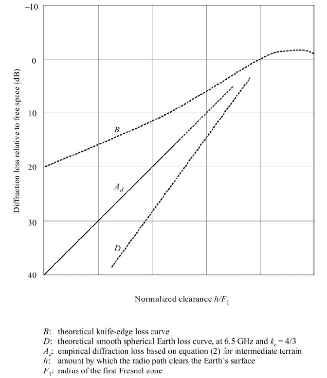
The ITU terrain model is based on diffraction theory and provides a relatively
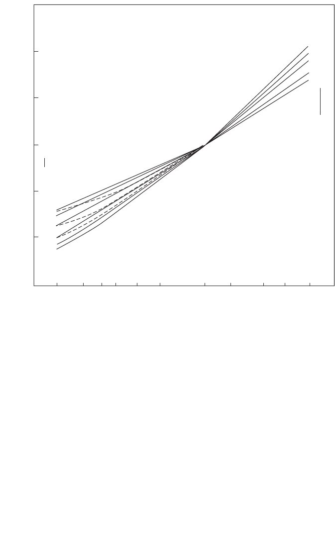
quick means of determining a median path loss [12]. Figure 7.7 shows three
plots of the expected diffraction loss due to terrain roughness versus the
normalized terrain clearance. Curve B is the theoretical knife-edge diffraction
curve. Curve D is the theoretical smooth-earth loss at 6.5 GHz using a 4/3 earth
radius. The curve labeled A
d
is the ITU terrain loss model over intermediate
terrain. Each of these curves represents the excess terrain loss, beyond free-
space loss. The ITU terrain loss model is given by
144 NEAR-EARTH PROPAGATION MODELS
–1.5 –1 –0.5 0 0.5 1
Figure 7.7 Additional loss due to terrain diffraction versus the normalized clearance.
(Figure 1 from Ref. 12, courtesy of the ITU.)
(7.10)
where h is the height difference between the most significant path blockage
and the line-of-sight path between the transmitter and the receiver. If the
blockage is above the line of sight, then h is negative. F
1
is the radius of the
first Fresnel zone (Fresnel zones are discussed in Chapter 8) and is given by
(7.11)
where
d
1
and d
2
are the distances from each terminal to the blockage in
kilometers
d is the distance between the terminals in km
f is the frequency in GHz
The ratio h/F
1
is the normalized terrain clearance (h/F
1
< 0 when the terrain
blocks the line of sight). This model is generally considered valid for losses
above 15 dB, but it is acceptable to extrapolate it to as little as 6 dB of loss as
shown in Figure 7.7. The other two curves shown represent extremes of clear
terrain and very rough terrain, so they provide insight into the variability that
can be expected for any given value of normalized clearance.
Example 7.3. A VHF military vehicle communication system needs to com-
municate with other military vehicles over a distance of 3 km over fairly rough
terrain (±2 m) at 100 MHz. The antenna is a 1.5-m whip mounted on the
vehicle, approximately 2 m above the ground. How much terrain loss should
be expected over and above the free-space loss?
The center of radiation for the antenna is 2.75 m above the ground. If a
flat-earth model is used, then the maximum terrain height of +2 m results in
a minimum antenna height above the terrain of
In the absence of specific information about the location of any blockage
within the line of sight, assume that the blockage occurs at the midpoint of the
path, d/2. The expression for F
1
reduces to
Next, by substituting d = 3 and f = 0.1 the value of F
1
is found to be
F
1
47 4= .
F
d
f
1
17 3
4
= .m
h = 075.m
F
dd
fd
1
12
17 3= .m
AhF
d
=- +20 10
1
dB
TERRAIN MODELING 145

The normalized terrain clearance is h/F
1
= 0.0158 and the terrain attenuation
is
which is consistent with Figure 7.7. The plot also shows that terrain loss in the
region of 6–15 dB might be reasonably expected. 䊐
7.4 PROPAGATION IN BUILT-UP AREAS
Propagation of electromagnetic waves through developed areas from sub-
urban to dense urban is of considerable interest, particularly for mobile tele-
phony. This is a vast subject with numerous papers and models available. The
actual propagation of RF though an urban environment is dependent upon
frequency, polarization, building geometry, material structure, orientation,
height, and density. This section treats propagation between elevated base sta-
tions and mobiles that are at street level in urban and suburban areas [13].
The goal is to determine the median path loss or RSL as a function of the dis-
tance, d, so that the required multipath fading models can then be applied
(Chapter 8). The median value depends heavily upon the size and density of
the buildings, so classification of urban terrain is important. The models dis-
cussed are the Young, Okumura, Hata, and Lee models.
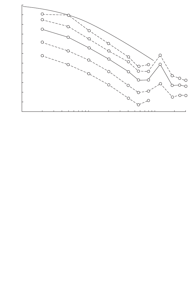
7.4.1 Young Model
The Young data were taken in New York City in 1952 and covers frequencies
of 150–3700 MHz [14, 15].The curve presented in Figure 7.8 displays an inverse
fourth-power law behavior, similar to the Egli model. The model for Young’s
data is
(7.12)
where b is called the clutter factor and is not the same b used in the Egli model!
This b is also distinct from the b sometimes used for building volume over a
sample area in classification [16]. From Young’s measurements, b is approxi-
mately 25 dB for New York City at 150 MHz. The data in Figure 7.8 suggests
that a log-normal fit to the variation in mean signal level is reasonable.
7.4.2 Okumura Model
The Okumura model is based on measurements made in Tokyo in 1960,
between 200 and 1920 MHz [17–20]. While not representative of modern U.S.
cities, the data and model are still widely used as a basis of comparison. The
LGG
hh
d
bm
bm
50
2
2
=
Ê
Ë
ˆ
¯
b
A
d
= 97.dB
146 NEAR-EARTH PROPAGATION MODELS
model is empirical, being based solely on the measured data. The actual path
loss predictions are made based on graphs of Okumura’s results, with various
correction factors applied for some parameters.
For the Okumura model, the prediction area is divided into terrain cate-
gories: open area, suburban area, and urban area. The open-area model rep-
resents locations with open space, no tall trees or buildings in the path, and
the land cleared for 300–400 m ahead (i.e., farmland). The suburban area
model represents a village or a highway scattered with trees and houses, some
obstacles near the mobile, but not very congested. The urban area model rep-
resents a built-up city or large town with large buildings and houses with two
or more stories, or larger villages with close houses and tall thickly grown trees.
The Okumura model uses the urban area as a baseline and then applies cor-
rection factors for conversion to other classifications. A series of terrain types
is also defined. Quasi-smooth terrain is the reference terrain and correction
factors are applied for other types of terrain. Okumura’s expression for the
median path loss is
(7.13)
where
LLAHH
FSL mu tu ru50
dB
()
=+--
PROPAGATION IN BUILT-UP AREAS 147
60
70
80
90
100
110
120
130
140
150
160
170
0.1 0.2 0.3 0.5 0.7 1.0 2 3 4 5 7 10 20 30
d, miles
Loss, dB
Flat terrain
1%
10%
50%
90%
99%
Figure 7.8 Results of Young’s measurement of path loss versus distance in miles in
Manhattan and the Bronx at 150 MHz. (Figure 7.1 from Ref. 15, courtesy of Artech
House.)
L
FSL
is the free-space loss for the given distance and frequency
A
mu
is the median attenuation relative to free-space loss in an urban area,
with quasi-smooth terrain, base station effective height h
te
= 200 m, and
mobile antenna height h
re
= 3m; the value of A
mu
is a function of both
frequency and distance
H
tu
is the base station height gain factor
H
ru
is the mobile antenna height gain factor
The signs on the gain factors are very important. Some works have reversed
the signs on the H terms, which will of course lead to erroneous results. If in
doubt, check the results using known test cases, or engineering judgment. For
instance, if increasing the antenna height increases the median path loss, then
the sign of the antenna height correction factor is clearly reversed.
Figure 7.9 shows plots of A
mu
versus frequency for various distances. Figure
7.10 shows the base station height gain factor in urban areas versus effective
148 NEAR-EARTH PROPAGATION MODELS
100
10
20
30
40
Basic median attentuation A
mu
(f, d ) (dB)
50
60
70
h
m
= 3 m
h
b
= 200 m
Urban area
200 300 500
Frequency f (MHz)
700 1000 2000
3000
100
100
80
80
60
60
50
50
40
40
30
30
20
20
10
10
5
5
2
2
1
1
d (km)
Figure 7.9 Plot of A
mu
versus frequency for use with the Okumura model. (Figure 4.7
Ref. 13, courtesy of Wiley.)
height for various distances, while Figure 7.11 shows the vehicle antenna
height gain factor versus effective antenna height for various frequencies and
levels of urbanization. Figure 7.12 shows how the base station antenna height
is measured relative to the mean terrain height between 3 and 15 km in the
direction of the receiver.
Example 7.4. Consider a system with the following parameters:
d = 37.km
f ==870 0 345MHz m, .l
h
r
= 3m
h
t
= 68 m
PROPAGATION IN BUILT-UP AREAS 149
30
20
10
–10
–20
–30
20 30 50
Base station effective antenna height h
te
(m)
70 100 200 300 500 700 1000
0
d (km)
d (km)
100
80
70
60
50
40
20
1
3
5
10
70~
100
60
40
20
1~10
Height gain factor H
tu
(h
te
, d ) (dB)
Urban area
h
te
= 200 m
Figure 7.10 Plot of H
tu
, the base station height correction factor, for the Okumura
model. (Figure 4.8 from Ref. 13, courtesy of Wiley.)
150 NEAR-EARTH PROPAGATION MODELS
2000
1000
700
400
200
100
100
200
400~
1000
20
15
10
Antenna height gain factor H
ru
(h
re
, f ) (dB)
5
0
–5
1
23 5710
Vehicular station antenna height h
re
(m)
400 MHz
200 MHz
Urban area
Medium cityLarge city
f (MHz)
Figure 7.11 Plot of H
ru
, the mobile station height correction factor for the Okumura
model. (Figure 4.9 from Ref. 13, courtesy of Wiley.)
3 km
15 km
Average height
h
te
h
t
h
Figure 7.12 Measuring effective transmitter height. (Figure 4.10 from Ref. 13, cour-
tesy of Wiley.)

What is the predicted path loss using the Okumura model?
First, it is readily determined that
Then the required correction factors from Figures 7.9 and 7.10 are incorpo-
rated to get the resulting median path loss:
Note that an H
ru
correction factor is not required since the mobile antenna is
at 3 m, which is the reference height. 䊐
7.4.3 Hata Model
The Hata model (sometimes called the Okumura–Hata model) is an empiri-
cal formulation that incorporates the graphical information from the
Okumura model [21–23]. There are three different formulas for the Hata
model: for urban areas, for suburban areas, and for open areas.
Urban Areas
(7.14)
where
150 < f
c
< 1500, f
c
in MHz
30 < h
t
< 200, h
t
in m
1 < d < 20, d in km
and a(h
r
) is the mobile antenna height correction factor. For a small- or
medium-sized city:
(7.15)
and for a large city:
(7.16)
ah
hf
hf
r
rc
rc
()
=
()()
-£
()()
-£
Ï
Ì
Ô
Ó
Ô
8 29 1 54 1 1 200
3 2 11 75 4 97 400
2
2
. log . . ,
. log . . ,
MHz
MHz
ah f h f h
rcr c r
()
=
()
-
()
-
()
-
()
££11 07 156 08 1 10. log . . log . , m
Lfhahhd
ctr t50
69 55 26 16 13 82 44 9 6 55dB
()
=+
()
-
()
-
()
+-
()
[]
()
. . log . log . . log log
L
50
102 6 26 8 136 6dB dB
()
=+--
()
=..
L
FS
= 102 6.dB
PROPAGATION IN BUILT-UP AREAS 151