Wai-Fah Chen.The Civil Engineering Handbook
Подождите немного. Документ загружается.

Simulation in Hydraulics and Hydrology
38
-3
Weather Service rainfall data and therefore can be used to read long precipitation records and can perform
storm event analysis. The TEMP block reads temperature, evaporation, and wind speed data that can be
obtained from the National Weather Service data base.
Name: Flood Damage Analysis System (HEC-FDA)
Source: U.S. Army Corps of Engineers
Hydrologic Engineering Center
609 Second Street
Davis, CA 95616
(916) 440–2105
www.hec.usace.army.mil
The User’s Manual can be downloaded from the Website.
The HEC-FDA program provides the capability to perform plan formulation and evaluation for flood
damage reduction studies. It includes risk-based analysis methods that follow Federal and Corps of
Engineers policy regulations (ER 1105–2–100 and ER 1105–2–101). Plans are compared to the condition
without flood protection by computing expected annual damage for each plan. Computations and display
of results are consistent with technical procedures described in EM 1110–2–1619. HEC-FDA will only
run on computers using Windows 95/98 or Windows NT.
Name: Modular Three-Dimensional Finite-Difference
Groundwater Flow Model (MODFLOW)
PC and Main Frame Versions
Source: U.S. Geological Survey
437 National Center
12201 Sunrise Valley Drive
Reston, VA 22092
(703) 648–5695
User’s manual:
McDonald, M.G. and Harbaugh, A.V.
U.S. Geological Survey Open-File Report
Books and Open-File Reports Section
U.S. Geological Survey
Federal Center
Box 25425
Denver, CO 80225
(303) 236–7476
Source code and processing programs:
International Groundwater Modeling Center (IGWMC)
Institute for Groundwater Research and Education
Colorado School of Mines
Golden, CO 80401 — 1887
Phone (303) 273–3103
Fax (303) 273–3278
or:
Scientific Software Group
P. O. Box 23041
Washington, D.C. 20026–3041
Phone (703) 620–9214
Fax (703) 620–6793
© 2003 by CRC Press LLC
38
-4
The Civil Engineering Handbook, Second Edition
or:
Geraghty & Miller
Software Modeling Group
10700 Parkridge Boulevard, Suite 600
Reston, VA 20091
Phone (703) 758–1200
Fax (703) 7581201
MODFLOW is a finite-difference groundwater model that simulates flow in three dimensions. The
modular structure of the program consists of a main program and a series of highly independent
subroutines called
modules
. The modules are grouped into
packages
. Each package deals with a specific
feature of the hydrologic system which is to be simulated, such as flow from rivers or flow into drains,
or with a specific method of solving linear equations that describe the flow system, such as strongly
implicit procedure or slice-successive overrelaxation.
Groundwater flow within the aquifer is simulated using a block-centered finite-difference approach. Layers
can be simulated as confined, unconfined, or a combination of the two. Flow associated with external entities,
such as wells, areal recharge, evapotranspiration, drains and streams, can also be simulated. The finite-differ-
ence equations can be solved using either the strongly implicit procedure or slice-successive overrelaxation.
Application of the computer program to solve groundwater flow problems requires knowledge of the
following hydrogeologic conditions: (1) hydraulic properties of the aquifer, (2) the shape and physical
boundaries of the aquifer system, (3) flow conditions at the boundaries, and (4) initial conditions of
groundwater flow and water levels.
The accuracy of the calibrated mathematical model is dependent on the assumptions and approxima-
tions in the finite-difference numerical solutions and the distribution and quality of data. Hydraulic
properties of the aquifer deposits (estimated by model calibration) can be used to define the flow system
and evaluate impacts that would be produced by changes in stress, such as pumping. However, three
main limitations that constrain the validity of the model are:
1. The inability of the numerical model to simulate all the complexities of the natural flow system.
The assumptions used for construction of the model affect the output and are simple compared
to the natural conditions.
2. The distribution of field data; for example, water level or lithologic data may not be areally or
vertically extensive enough to define the system adequately.
3. The model is probably not unique. Many combinations of aquifer properties and recharge-
discharge distributions can produce the same results, especially because the model is usually
calibrated for a predevelopment (steady state) condition. For example, a proportionate change in
total sources and sinks of water with respect to transmissivity would result in the same steady
state model solution.
Name: HEC-6 Scour and Deposition in Rivers and Reservoirs
PC and Main Frame versions
Source: Hydrologic Engineering Center
U.S. Army Corps of Engineers
609 Second Street
Davis, CA 95616–4687
(916) 756–1104
User’s manual:
U.S. Army Corps of Engineers.
1993
. HEC-
6
: Scour and Deposition in Rivers and Reservoirs – User’s
Manual.
Hydrologic Engineering Center.
1987
. COED: Corps of Engineers Editor User’s Manual.
Thomas, W.A., Gee, D.M., and MacArthur, R.C. 1981. Guidelines for the Calibration and Appli-
cation of Computer Program HEC-6.
© 2003 by CRC Press LLC

Simulation in Hydraulics and Hydrology
38
-5
Availability of user’s manuals:
National Technical Information Service
5825 Port Royal Road
Springfield, Virginia 22161
(703) 487–4650
(703) 321–8547
HEC-6 is a member in the series of numerical models developed by the U.S. Army Corps of Engineers
Hydrologic Engineering Center for studies of hydraulic or hydrologic problems. It is a one-dimensional
model of a river or reservoir where entrainment, deposition, or transport of sediment occur. It is intended
for use in the analysis of long-term river or reservoir response to changes in flow or sediment conditions.
In HEC-6, models change as a sequence of steady states; the hydraulic and sediment parameters of each
may vary during the sequence. It can be applied to analyze problems arising in or from stream networks,
channel dredging, levee design, and reservoir deposition.
The hydraulic model is essentially identical to that used in HEC-RAS (see the description of HEC-RAS
for more details), in which water-surface profiles are computed by using the standard step method and
with flow resistance modeled with Manning’s equation. Although flow resistance due to bed forms is not
separately considered, Manning’s
n
can be specified as a function of discharge. In a “fixed bed” mode,
the sediment transport model can be turned off, and HEC-6 can be used as a limited form of HEC-RAS
without capabilities for special problems such as bridges or islands. The input format of HEC-6 is very
similar to the format of HEC-2, which is the program for computing water-surface profiles which
preceded HEC-RAS.
The sediment transport model is based on the Exner equation (see Chapter 35, Eq. [35.29]). It treats
graded sediments, ranging from clays and silts to boulders up to 2048 mm in diameter, by dividing both
inflow and bed sediments up to 20 size classes. Several standard transport formulas for sand and gravel
sizes are available and provision for a user-developed formula is included. Additional features include
the modeling of armoring, clay and silt transport, and cohesive sediment scour. Because it is a one-
dimensional model, it does not model bank erosion, meanders, or non-uniform transport at a given
cross section.
38.3 TR-20 Program
The TR-20 computer program was developed by the Natural Resources Conservation Service (1982) to
assist in the hydrologic evaluation of storm events for water resource projects. TR-20 is a single-event
model that computes direct runoff resulting from synthetic or natural rainfall events. There is no
provision for recovery of initial abstraction or infiltration during periods without rainfall. The program
develops runoff hydrographs from excess precipitation and routes the flow through stream channels and
reservoirs. It combines the routed hydrograph with those from tributaries and computes the peak
discharges, their times of occurrence, and the water elevations at any desired reach or structure. Up to
nine different rainstorm distributions over a watershed under various combinations of land treatment,
flood control structures, diversions, and channel modifications may be used in the analyses. Such analyses
can be performed on as many as 200 reaches and 99 structures in any one continuous run (NRCS, 1982).
The program can be obtained from National Technical Information Service, U.S. Department of Com-
merce, 5285 Port Royal Road, Springfield, VA 22161, (703) 487-4600.
Summary of TR-20 Input Structure
The input requirements of TR-20 are few. If data from actual rainfall events are not used, the depth of
precipitation is the only required meteorological input. For each subarea, the drainage area, runoff curve
number and time of concentration are required; the antecedent soil moisture (AMC) condition (i.e., I, II,
or III) can be specified, although the NRCS now recommends only AMC II, the so-called average runoff
condition (NRCS, 1986). For each channel reach, the length is defined; the channel cross section is defined
© 2003 by CRC Press LLC
38
-6
The Civil Engineering Handbook, Second Edition
by the discharge and end area data at different elevations; a routing coefficient, which is defined by the
discharge and end area data at different elevations; a routing coefficient, which is optional, may also be
specified. If the channel-routing coefficient is not given as input, it will be computed by using a modified
Att-Kin (attenuation-kinematic) procedure.
The modified Att-Kin routing procedure is described in TR-66 (NRCS, 1982). It uses storage and
kinematic models to attenuate and translate natural flood waves. For each channel reach, the Att-Kin
procedure routes an inflow hydrograph through the reach using a storage model. With the storage and
kinematic models, flows are routed as a linear combination so that the outflow hydrograph satisfies the
conservation of mass at the time to peak of the outflow hydrograph. Used separately, the storage routing
provides only attenuation without translation; the kinematic routing provides only translation and
distortion without attenuation of the peak (NRCS, 1982).
For each structure it is necessary to describe the outflow characteristics with an elevation-discharge-
storage relationship. The time increment for all computations and any baseflow in a channel reach must
be specified.
Input Structure
The input for a TR-20 consists of the following four general statement types: Job Control, Tabular Data,
Standard Control statements, and Executive Control statements.
Job Control
The Job Control statements are the JOB statement, two TITLE statements, ENDATA statement, ENDCMP
statement, and ENDJOB statement. The JOB and two TITLE statements
must
appear first and second,
respectively, in a run and the ENDJOB statement must appear last. The ENDATA statement separates
the standard control and the tabular data from the executive control statements. The ENDCMP statement
is used to signify the end of a pass through a watershed or a sub-watershed thereby allowing conditions
to be changed by the user before further processing.
Input data are entered according to the specifications in a blank form. Each line of data on the form
is a record entered into the computer file. The 80 columns across the top of the form represent the 80
positions on a record. Each statement is used to perform a specific operation. The order of records
determines the sequence in which the operations are performed.
A name appears in columns 4 through 9 of all lines except those containing tabular data. These names
identify the type of operation performed or type of data entered. A number corresponding to the name
in columns 4 through 9 is placed in columns 2 and 11. The digit in column 11 is the operation number
and identifies the type of operation, which must be entered unless it is a blank.
Ta bular Data
The tabular data serve as support data for the problem description. These data precede both the Standard
and Executive Control and have six possible tables:
1.
Routing coefficient table
: the relationship between the streamflow routing coefficient and velocity.
2.
Dimensionless hydrograph table
:
the dimensionless curvilinear unit hydrograph ordinates as a
function of dimensionless time.
3. Cumulative rainfall tables.
4.
Stream cross
-
section data tables
:
a tabular data summary of the water surface elevation-discharge-
cross sectional end area relationship.
5.
Structure data table
: a tabular summary of the water surface elevation-discharge-reservoir storage
relationship.
6.
Read
-
discharge hydrograph data table;
a hydrograph that is entered directly into the program as
data.
For example, the data needed to support a cumulative rainfall table include a rainfall table number,
time increment, runoff coefficient (if desired), and the cumulative rainfall values for the modeled rainfall
event. The cumulative rainfall values used in the following examples are the SCS Type II distribution.
© 2003 by CRC Press LLC
Simulation in Hydraulics and Hydrology
38
-7
Standard Control Operations
Standard Control consists of the following six subroutine operations. There can be up to 600 Standard
Control statements for each TR-20 program.
1. RUNOFF: an instruction to develop a subbasin runoff hydrograph
2. RESVOR: an instruction to route a hydrograph through a structure or reservoir
3. REACH: an instruction to route a hydrograph through a channel reach
4. ADDHYD: an instruction to combine two hydrographs
5. SAVMOV: an instruction to move a hydrograph from one computer memory storage location to
another
6. DIVERT: an instruction for a hydrograph to be separated into two parts.
As an example, the data needed to support the standard RUNOFF control operation are the area, curve
number, and time of concentration. The operations are indicated on the input lines in columns 2, 4–9,
and 11. The number 6 is placed in column 2 to indicate standard control. The name of the subroutine
operation is placed in columns 4–9. The operation number, which is placed after the operation name
(e.g., 1 for RUNOFF, 6 for DIVERT), is placed in column 11.
Column 61, 63, 65, 67, 69, and 71 of standard control records are used to specify the output. The
individual output options are selected by placing a 1 in the appropriate column. If either the column is
left blank or a zero is inserted, the corresponding option will not be selected. Table 38.1 summarizes the
output options. If only a summary table is desired, it is convenient to place SUMMARY in columns
51–57 in the JOB statement and leave all the output options on the standard control records blank.
Executive Control
The Executive Control has two functions: (1) to execute the Standard Control statements, and (2) to
provide additional data necessary for processing. The Executive Control consists of six types of statements.
They are LIST, BASFLO, INCREM, COMPUT, ENDCMP, and ENDJOB. The Executive Control state-
ments are placed after the Standard Control statements and tabular data to which they pertain.
The Standard Control is used to describe the physical characteristics of the watershed. The Executive
Control is used to prescribe the hydrologic conditions of the watershed including the baseflow. The
performance for the Executive Control is directed by the COMPUT statement. Its purpose is to describe
the rainfall and the part of the watershed over which that rainfall is to occur (NRCS, 1982).
For the examples discussed in this section, the INCREM, COMPUT, ENDCMP, and ENDJOB will be
the only executive control statements required to fulfill the operations requested.
Preparation of Input Data
Preparation of input data can be divided into the following requirements and functions:
1. Prepare a schematic drawing that conveniently identifies the locations, drainage areas, curve
numbers (CN), times of concentration (
t
c
), and reach lengths for the watershed. It should display
all alternate structure systems together with the routing and evaluation reaches through which
they are to be analyzed.
TABLE
38.1
Output Options for TR-20
Output
Option
A “1” in
Column Produces the following printout
PEAK 61 Peak discharge and corresponding time of peak and elevation (maximum storage elevation for
a structure)
HYD 63 Discharge hydrograph ordinates.
ELEV 65 Stage hydrograph ordinates (reach elevations for a cross section and water surface elevation for
structures).
VOL67Volume of water under the hydrograph in inches depth, acre-feet, and ft
3
/sec-hours.
SUM 71 Requests the results of the subroutine be inserted in the summary tables at the end of the job.
© 2003 by CRC Press LLC
38
-8
The Civil Engineering Handbook, Second Edition
2. Establish a Standard Control list for the watershed.
3. List the tabular data to support the requirements of the Standard Control list. This may consist
of structure data, stream cross section data, cumulative rainfall data, and the dimensionless
hydrograph table.
4. Establish the Executive Control statements that describe each storm and alternative situation that
is to be analyzed through the Standard Control list.
Calculations
For a large watershed it may be necessary to divide the watershed into subbasins. Each subbasin is
determined by finding the different outlet points or design points within the watershed, then finding the
area contributing to those points.
1.
Area
. The area of each subbasin in square miles (mi
2
).
2.
Curve number
.
The curve number (CN) for each subbasin.
3.
Time of concentration
. Following the curve number, the time of concentration (
t
c
) is specified for
each subbasin.
Forms for Input Data
Blank forms for the TR-20 data are found in NRCS (1982). The example problems therein demonstrate
how the forms are completed. The process is straightforward because of the instructions given and the
preselected columns for the data. The output options are shown in Table 38.1.
Examples
A 188.5-acre basin in modeled to determine the discharge and required storage as a result of development.
The first example models a subbasin with existing conditions. The third example incorporates the entire
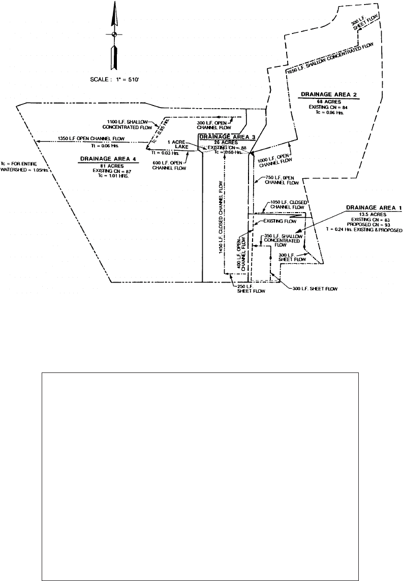
basin to determine the peak discharge at the outlet. The area is located in Indianapolis and is shown in
Fig. 38.1.
Example 38.1
Referring to Fig. 38.1, drainage area 1 is modeled to determine the runoff for present conditions. This
area is a small part of the total drainage area of the watershed in Fig. 38.1.
Hydrological Input Data
The cumulative rainfall data used is the SCS Type II rainfall distribution. The intensity-duration-fre-
quency tables for Indianapolis, Indiana, are used with the 6-hour rainfall depth for the 10-year event to
generate the surface-runoff hydrograph for the subbasins. The SCS 24-hour distribution was scaled to
give a 6-hr hyetograph. The point rainfall depth is 3.23 in./hr.
Calculations
Area
. The area of subbasin 1 is 13.5 acres or 0.021 mi.
2
Curve number
. There are two different land uses for this subbasin; therefore both areas must be
calculated and a composite curve number determined for the respective area. An open area of
7.6 acres has a CN of 74. The other land use is commercial with 5.9 acres and a CN of 94. The
product of curve number and area is 1117. The sum of the product of the curve numbers and
areas is then divided by the total area of the drainage area 1 to find an overall composite CN of 83.
Time of concentration. The time of concentration is computed by assuming 300 ft. of sheet flow,
350 ft. of shallow concentrated flow over unpaved surface, and channel flow length of 1150 ft. The
channel flow is computed to the lake, not the watershed boundary. The time is 0.24 hr.
Computer Input
The following section demonstrates where, for this example, the information is input to the computer.
The following discussion is based on the input file shown in Fig. 38.2.
© 2003 by CRC Press LLC
Simulation in Hydraulics and Hydrology
38
-9
FIGURE 38.1
Location map.
JOB TR 20 NOPLOTS
TITLE EXAMPLE 1 DRAINAGE AREA 1
TITLE EXISTING CONDITIONS
5 RAINFL 7 0.05
800.0125 0.25 0.04 0.06
8 0.08 0.1 0.13 0.165 0.22
8 0.64 0.78 0.835 0.87 0.895
8 0.92 0.94 0.96 0.98 0.99
811.0 1.0 1.0 1.0
9 ENDTBL
6 RUNOFF 1 1 1 0.021 83 0.24 1 1 0 1 0 1 AREA 1
ENDATA
7 INCREM 6 0.1
7 COMPUT 7 1 10.0 3.23 6. 7 2 1 1 10-YR
ENDCMP 1
ENDJOB 2
FIGURE 38.2
Input for Example 38.1.
© 2003 by CRC Press LLC
38
-10
The Civil Engineering Handbook, Second Edition
1. The first input is the JOB and TITLE. For this example NOPLOTS is entered in columns 61–67,
which indicates that cross section discharge-area plots are not desired. Two TITLE statements are
used to describe the problem and the rainfall information.
2. Next the cumulative rainfall table is used to describe the rainfall event. The statement describing
this operation is RAINFL. There are six standard rainfall distributions which may be used and
these are preloaded into TR-20. The user need not input these tables, but use only the proper rain
table identification number on the COMPUT statement, in column 11. The user may override
any of these tables by entering a new RAINFL table and entering 7, 8, or 9 in column 11. For this
example a 7 is placed in column 11 indicating that a rainfall table will be specified by the user.
Rainfall depths in inches can also be used. If these are used, the data code in column 2 needs to
be changed to 8. The rainfall table of SCS Type II distribution is placed in the proper columns
below the RAINFL statement as shown in Fig. 38.2. The time increment used for this example is
0.05 hr, determined by the number of cumulative rainfall points and the storm duration. The
number of rainfall increments is 20, so that each increment is 0.05 of the total. This number, 0.05
is entered into columns 25–36. The 6-hour storm duration is entered on the COMPUT statement.
3. For this example, the runoff from area 1 is computed with the RUNOFF statement with the proper
codes, described previously. This is the only standard control statement needed for this example.
ENDATA indicates that the input information for the runoff is complete. Comments in columns
73 through 80 are helpful reminders.
4. The Executive Control statement is then used to indicate which computations are desired. This
runoff from area 1 is computed for the 10-year rainfall. The INCREM statement causes all the
hydrographs generated within the TR-20 program to have a time increment of 0.1 hours, as
specified in columns 25–36, unless the main time increment is changed by a subsequent INCREM
statement. The 7 in column 61 refers the COMPUT to rainfall table 7, the cumulative rainfall
table. The AMC number is given in column 63 for each COMPUT (computation). For this example
the AMC is 2. The starting time, rainfall depth, and rainfall duration are given for each recurrence
interval. In this example, the starting time is 0.0, the rainfall depth is 3.23 in., and the duration
is 6 hr. These values are placed in their corresponding columns. A COMPUT and an ENDCMP
statement are necessary for each recurrence interval. ENDJOB is then used to signify that all the
information has been given and the calculations are to begin. The Executive Control data are
shown on Fig.38.2.
Output
The type and amount of output are controlled by input options on the JOB record and by the output
options on the Standard Control records. For this example, by declaring NOPLOTS in columns 61–67
of the JOB record, plots are suppressed. The RUNOFF statement requested to have the peak discharge,
volume of water under the hydrograph, and a summary table of the results, because a “1” was placed in
columns 61, 67, and 71 in this statement. The output for this example is shown in Fig. 38.3.
Summary/Explanation
The table in Fig. 38.3 summarizes all of the information obtained. From this table it can be seen that,
for a rainfall event with a 10-year recurrence interval, the amount of runoff from Area 1 is 1.64 in. for
a 6-hour duration. The peak discharge occurs after 3.08 hours and has a flow rate of 30.72 cfs.
Example 38.2
Description
The runoff from area 1 is computed for developed conditions and a pond is added inside area 1. A stage-
storage-discharge relationship is required for the structure, and the attenuation effects are evaluated. The
hydrologic input data area the same as that which was used in Example 38.1. The input for example 38.2
is shown in Fig. 38.4.
© 2003 by CRC Press LLC

Simulation in Hydraulics and Hydrology
38
-11
EXECUTIVE CONTROL OPERATION INCREM RECORD ID
+
MAIN TIME INCREMENT = .10 HOURS
EXECUTIVE CONTROL OPERATION COMPUT RECORD ID 10-YR
+
FROM XSECTION 1
+
TO XSECTION 1
STARTING TIME = .00 RAIN DEPTH = 3.23 RAIN DURATION = 6.00 RAIN TABLE NO. = 7 ANT. MOIST. COND = 2
ALTERNATE NO. = 1 STORM NO. = 1 MAIN TIME INCREMENT = .10 HOURS
OPERATION RUNOFF CROSS SECTION 1
PEAK TIME(HRS) PEAK DISCHARGE(CFS) PEAK ELEVATION(FEET)
3.08 30.72 (RUNOFF)
5.35 2.40 (RUNOFF)
TIME
(HRS) FIRST HYDROGRAPH POINT = .00 HOURS TIME INCREMENT = .10 HOURS DRAINAGE AREA = .02 SQ.MI.
FIGURE 38.3
Output from Example 38.1.
2.00 DISCHG 0 0 0.02 0.12 0.26 0.49 0.88 1.32 4.93 16.04
3.00 DISCHG 27.38 30.47 22.64 17.67 14.47 9.95 7.49 6.23 4.98 4.34
4.00 DISCHG 3.92 3.35 3.05 2.95 2.92 2.91 2.81 2.56 2.42 2.38
5.00 DISCHG 2.37 2.36 2.37 2.37 2.37 2.16 1.65 1.36 1.25 1.22
6.00 DISCHG 1.2 0.98 0.46 0.16 0.06 0.02 0.01 0
RUNOFF VOLUME ABOVE BASEFLOW = 1.64 WATERSHED IN., 22.18 CFS-HRS, 1.83 ACRE-FT; BASEFLOW = .00 CFS
EXECUTIVE CONTROL OPERATION ENDCMP RECORD ID
+ COMPUTATIONS COMPLETED FOR PASS 1
EXECUTIVE CONTROL OPERATION ENDJOB RECORD ID
TR20 XEQ 12–05–01 05:28 EXAMPLE 1 - DRAINAGE AREA 1 JOB 1 SUMMARY
REV PC 09/83(.2) EXISTING CONDITIONS PAGE 1
SUMMARY TABLE 1 - SELECTED RESULTS OF STANDARD AND EXECUTIVE CONTROL
INSTRUCTIONS IN THE ORDER PERFORMED (A STAR(*) AFTER THE PEAK DISCHARGE TIME AND RATE (CFS) VALUES
INDICATES A FLAT TOP HYDROGRAPH A QUESTION MARK(?) INDICATES A HYDROGRAPH WITH PEAK AS LAST POINT.
SECTION/
STRUCTURE
ID
STANDARD
CONTROL
OPERATION
DRAIN.
AREA
RAIN
TABLE
#
ANTEC
MOIST
COND
MAIN
TIME
INCREM
(HR)
PRECIPITATION
RUNOFF
AMOUNT
(IN)
PEAK DISCHARGE
BEGIN
(HR)
AMOUNT
(IN)
DURATION
(HR)
ELEV.
(FT)
TIME
(HR)
RATE
(CFS)
RATE
(CSM)
ALTERNATE 1 STORM 1
XSECTION 1 RUNOFF 0.02 7 2 0.1 0 3.23 6 1.64 — 3.08 30.72 1463.1
SUMMARY TABLE 3 - DISCHARGE (CFS) AT XSECTIONS AND STRUCTURES FOR ALL STORMS AND ALTERNATES
XSECTION DRAINAGE
STRUCTURE AREA STORM NUMBERS……
ID (SQ MI) 1
0 XSECTION 1 .02
+______________________________________
ALTERNATE 1 30.72
END OF 1 JOBS IN THIS RUN
© 2003 by CRC Press LLC

38
-12
The Civil Engineering Handbook, Second Edition
Calculations
Once the proposed pond is designed, the discharge and storage is computed at different elevations by
the user. The discharge from the pond is controlled by the outlet structure. Table 38.2 shows the stage-
storage-discharge relationship for the pond. For example, at elevation 783.0 feet, the discharge is 15.0
cfs and the storage is 0.88 acre-ft. This is an ungated control structure with headwater control.
The CN for the developed condition is 93 and the time of concentration is 0.24 hours.
1. The TITLE statement is adjusted to show the proper example problem number and description.
2. As mentioned previously, the same rainfall table will be used.
3. After the ENDTBL statement of the rainfall table, the structure table for the pond is added. The
initial values for the stage-storage-discharge relationship must have the elevation of the invert of
the outlet structure and 0.0 values for the discharge and storage. All data entered in this table
must have decimal points and must increase between successive lines of data. The STRUCT table
JOB TR-20 NOPLOTS
TITLE EXAMPLE 2 - DRAINAGE AREA 1
TITLE PROPOSED CONDITIONS
5 RAINFL 7 0.05
800.0125 0.025 0.04 0.06
8 0.08 0.1 0.13 0.165 0.22
8 0.64 0.78 0.835 0.87 0.895
8 0.92 0.94 0.96 0.98 0.99
8 1.0 1.0 1.0 1.0 1.0
9 ENDTBL
3 STRUCT 01
8 780.5 0 0
8 781 2 0.004
8 781.5 4 0.014
8 782 8 0.019
8 782.5 12 0.046
8 783 15 0.88
8 783.5 20 1.33
8 784 23 1.67
8 784.5 28 2.07
8 785 30 2.46
8 785.5 32.5 2.85
8 786 35 3.23
8 786.5 36 3.49
8 787 40 4.52
9 ENDTBL
6 RUNOFF 1 1 1 0.021 93. 0.24 1 1 0 1 0 1
6 RESVOR 2 01 1 2 1 0 0 1 0 1
ENDATA
7 INCREM 6 0.1
7 COMPUT 7 1 01 0.0 3.23 6. 7 2 1 1
ENDCMP 1
ENDJOB 2
FIGURE 38.4
Input for Example 38.2.
© 2003 by CRC Press LLC