Battarbee R.W., Binney H.A. (Eds.) Natural Climate Variability and Global Warming: A Holocene Perspective
Подождите немного. Документ загружается.

..
210
|
Dirk Verschuren and Dan J. Charman
..
response of individual Saharan lakes to an abrupt decrease in rainfall may have
been either rapid or gradual (Salzmann and Waller 1998), depending on whether
there was continued groundwater input from surrounding aquifers long after
recharge was reduced. In the driest continental areas, an abrupt humid-to-arid
transition recorded sometime between 7000 and 4000 years BP in a hydrologically
favored lake basin can simply mean that summer monsoon rainfall no longer
reached the area (Fleitmann et al. 2007a). A synoptic compilation of geologic and
archaeologic data from the eastern Sahara over the past 12 000 years shows that
Holocene aridification progressed gradually from ca. 7300 years BP to the present
day (Küper and Kröpelin 2006). Similarly, palynologic and paleolimnologic
data from the western Sahel region of North Africa (10°N, 12°E) indicate that
the early Holocene humid period there ended in a gradual decline of the precipi-
tation/evaporation ratio, not obviously interrupted by abrupt climatic events
(Salzmann et al. 2002).
Century-scale moisture-balance variation during the late Holocene
The three most recent weak monsoon events in the Asian monsoon record at
Dongge Cave (Wang et al. 2005) occur at 2800–2700, 1500–1600, and 600–400
years BP. The latter corresponds with the most recent Bond cold event in the North
Atlantic, but is rather tenuously expressed, short-lived, and is immediately fol-
lowed by a pronounced intensification of the Asian Monsoon over the past 400
years, also recorded in Arabian Sea sediments (Anderson et al. 2002). Similar
century-scale hydrologic events affecting the African continent during the past
3000–4000 years are difficult to correlate spatially because of poor geographic
coverage and limited age control on available climate-proxy records, and frequent
hiatuses in lake-sediment records due to intermittent complete desiccation. The
speleothem record of Indian monsoon activity in Oman (Fleitmann et al. 2003) is
also interrupted between 3000 and 1500 years BP, suggesting that this extended
period may have been the driest of the Holocene, excluding short-lived hyper-arid
spells at other times. In the central Sahara, arid to hyper-arid conditions have
prevailed since 3200 years BP (Hoelzmann et al. 2004).
Pollen data of Sahel vegetation in Nigeria (Salzmann and Waller 1998) and a
reappraisal of the principal late Holocene regression of Lake Bosumtwi, Ghana
(Russell et al. 2003) suggest that pronounced drying in tropical West Africa started
at or shortly before 3200–3300 years BP. Lake-status and pollen records from
the Atlantic side of intertropical Africa typically show dry conditions between
3000–2800 and 2000 years BP (Stager and Anfang-Sutter 1999; Vincens et al. 1999;
Wirrmann et al. 2001; Giresse et al. 2004), often with a clear aridity maximum
around 2800–2500 years BP (Reynaud-Farrera et al. 1996; Maley and Brenac
1998). Peak late Holocene aridity in West Africa is thus coeval with a weakened
Asian monsoon and North Atlantic cold event 2.
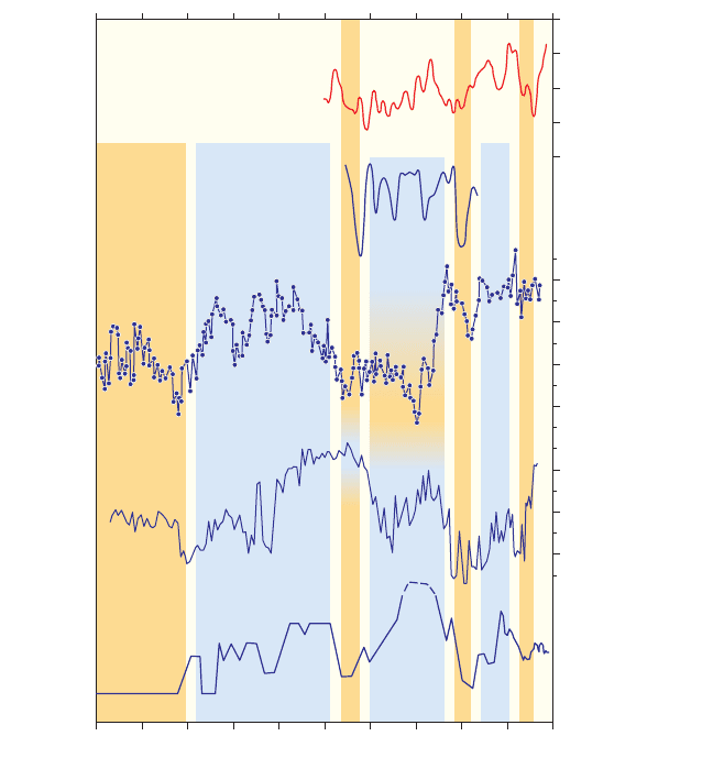
Using percent Mg in authigenic calcite as a proxy indicator for the water balance
of Lake Edward, Russell and Johnson (2005b) constructed a chronologically
9781405159050_4_008.qxd 6/3/08 3:58 PM Page 210

Latitudinal linkages in moisture-balance variation
|
211
..
well-constrained record of rainfall and drought for central equatorial Africa (the
western shoulder of the East African Plateau) for the past 5400 years. It reveals
a chronology of century-scale drought events at 4100–3950, 3600–3400, 2750–
2600, 2050–1850, 1500, and 900–700 years BP, superimposed on a mid-Holocene
drying trend that may have reversed to slightly wetter average conditions in the
past two millennia (Figure 8.11). The driest conditions in this region thus appear
to have occurred during the 2050–1850 years BP event, not the ca. 2650 years BP
event. Integration with proxy water-balance records from lakes Tanganyika (Alin
and Cohen 2003), Turkana (Halfman et al. 1994), Naivasha (Verschuren 2001)
and small crater lakes in western Uganda (Russell et al. 2007) indicates that this
general pattern may hold true for both western and eastern portions of the East
African Plateau, and that drought at ca. 2000 years BP affected much, if not all, of
equatorial Africa. The shift to a slightly wetter mean climate regime at the Equator
in recent millennia may reflect an intensification of the north-eastern monsoon,
due to enhanced Southern Hemisphere summer insolation (Russell and Johnson
2005a).
A review of diverse paleodata covering the past two millennia of tropical African
climate history (Verschuren 2004) suggested that drought was also widespread
in eastern equatorial Africa during the period ca. ad 900–1250, i.e. broadly coincid-
ent with the period of mostly warm conditions in high northern latitudes defined
as the Medieval Warm Period (MWP) or Medieval Climate Anomaly (MCA)
(Lamb 1985). Distinct regional climatic anomalies within this period together with
inadequate dating control on many relevant paleodata continue to hamper a
world-wide synthesis of this period (Hughes and Diaz 1994; Bradley et al. 2003),
but relatively dry conditions also prevailed further away from the Equator in
Ethiopia (Lamb et al. 2007b) and in south-eastern tropical Africa (Owen et al.
1990). In all these locations, Medieval drought ended in the mid- to late-13th cen-
tury with a pronounced shift to more positive water balance. Although widespread
..
0
10
20
4
2
0
Detrended Mg
(mol %)
Stacked Mg
(mol %)
–2
–4
5000 4000 3000
Calendar years BP
2000 1000 0
(a)
(b)
Figure 8.11 Percent Mg in
authigenic calcite from Lake
Edward (Uganda) as proxy
indicator for rainfall and
drought in central equatorial
Africa over the past 5500
years. (a) Composite record
based on integration of data
from successively deeper
cores; (b) same record after
removal of the long-term
trend. (Modified from Russell
and Johnson (2005b).
Copyright Elsevier (2005).)
9781405159050_4_008.qxd 6/3/08 3:58 PM Page 211
..
212
|
Dirk Verschuren and Dan J. Charman
..
on the African continent, the Medieval dry period post-dates the episode of inter-
mittent severe aridity in sub-tropical Central America that has been linked to the
collapse of Maya civilization (1200–1050 years BP, or ad 700–900: Hodell et al.
2001; Haug et al. 2003). Drought in Central America is typically thought to imme-
diately precede the local equivalent to the MWP, which started ca. 900 years BP
with a shift to a variable but generally more positive water balance, then evolved
into a drier climate regime by ad 1100–1200 (Haug et al. 2003), i.e. coeval with
“High Medieval” warming in north-temperate Europe (Bradley et al. 2003). A
pronounced drought episode affecting the western Sahel region of North Africa
(Holmes et al. 1998) is dated to 1200–1000 years BP, however, and thus coeval with
Central American drought (Street-Perrott et al. 2000). Less well constrained
chronologically, Lake Chad in the central Sahel also appears to have registered a
transgression, rather than lake-level decline, at about 1000 years BP (Maley 1993).
The Central and East African MWP-equivalent drought is therefore clearly distinct
from pre-MWP drought in Central America (Russell and Johnson 2005b) and
the presumed pre-MWP drought in the North African Sahel. Low-resolution vege-
tation reconstructions from Gabon (Ngomanda et al. 2005) and Namibia (Scott
1996) reveal more or less continuous drought/warmth for a 500-year period
encompassing the 8th through 13th centuries, suggesting that pre-MWP (Atlantic)
and MWP-equivalent (Central and East African) drought had an impact on areas
along the Atlantic Ocean coast in immediate succession.
The African Little Ice Age
During the time period equivalent with the Little Ice Age (LIA) in high-latitude
regions, hydrologic variations in tropical Africa are divisible into an “early” LIA
phase ca. ad 1250–1550 and a “main” LIA phase ca. ad 1550–1850. The start of the
“early” LIA follows the glaciologic definition of the Little Ice Age, starting with
pronounced glacier advance in the European Alps around ad 1250 (Holzhauser
1997) and expansion of sea ice around Iceland. In most of tropical Africa around
this time, a marked shift to improved moisture balance ended the African equival-
ent of the MWP. The “main” LIA is temporally broadly equivalent to the climati-
cally defined Little Ice Age in Europe, i.e. ca. ad 1570–1900, when Northern
Hemisphere summer temperatures fell significantly below the modern mean
(Matthews and Briffa 2005).
Although there is considerable uncertainty in the chronology of available proxy
records, Central Africa from the Equator to 11°S and further south into eastern
South Africa all appear to have enjoyed relatively moist conditions only during
the early LIA from ca. ad 1250–1300 to 1500–1550, then switched to a sustained
drying trend that eventually culminated in severe 18th century drought. This
regional picture now includes evidence from Lake Edward (Figure 8.12c; Russell
and Johnson 2007), western Ugandan pollen records (Marchant and Taylor 1998)
and crater lakes (Russell et al. 2007), Lake Tanganyika (Alin and Cohen 2003),
Lake Malawi (Brown and Johnson 2005), Lake Masoko in southern Tanzania
(Garcin et al. 2007b), and the speleothem record from Cold Air Cave, South Africa
9781405159050_4_008.qxd 6/3/08 3:58 PM Page 212
Latitudinal linkages in moisture-balance variation
|
213
..
(Holmgren et al. 1999, 2003; Lee-Thorp et al. 2001). In eastern equatorial Africa,
however, these moist conditions persisted until the mid-18th century, i.e. during
much of the main LIA, before ending in late 18th century drought. This includes
evidence from Lake Naivasha (Figure 8.12e; Verschuren et al. 2000) and Loboi
Swamp (Ashley et al. 2004; Driese et al. 2004) in central Kenya, Lake Victoria
(Figure 8.12d; Stager et al. 2005), and the Mount Kilimanjaro ice-core record
(Gasse 2002; Thompson et al. 2002). Thus, following widespread drought in
Medieval time (ca. ad 1000 to 1250) and widespread wet conditions during the
early LIA (ca. ad 1250 to 1500–1550), a pronounced regional gradient developed
during the main LIA, with above-average wet conditions in eastern equatorial
Africa (Figure 8.12e) coinciding with relative drought in westernmost East Africa
and southern tropical Africa (Figure 8.12c).
As recorded at Lake Naivasha in central Kenya, the relative wetness of eastern
equatorial Africa between ca. ad 1250 and the late 18th century was interrupted
by two decade-scale episodes of severe drought dated to ca. ad 1380–1420 and
..
(a) Winter NAO
(b) Luanda, 13°E
(c) Edward, 29°E
(d) Victoria, 33°E
(e) Naivasha, 36°E
% Mg in calciteLake Victoria
(% SWD)
1.0
0.5
0
–0.5
–1.0
16
18
20
22
20
40
60
0180016001400
Years BP
12001000
Figure 8.12 West-to-east
transect of lake-based
moisture-balance
reconstructions across the
East African Plateau for the
past 1000 years, compared
with shorter reconstructions
of the North Atlantic
Oscillation and drought along
the Atlantic coast of
equatorial Africa. (a) 30-year
running mean of NAO/AO
index. (From Luterbacher
et al. (2002) with kind
permission from Springer
Science and Business Media.)
(b) Luanda (Angola) drought
index based on Portuguese
trader data, summed per
decade (from Miller 1982).
(c) Percent Mg in authigenic
calcite from Lake Edward,
western Uganda. (Modified
from Russell and Johnson
(2007). Copyright Elsevier
(2007).) (d) Percent shallow-
water diatoms in Pilkington
Bay, Lake Victoria. (From
Stager et al. (2005) with kind
permission from Springer
Science and Business Media.
(e) Lithology-inferred water
depth of Lake Naivasha,
central Kenya (from
Verschuren et al. 2000). Blue
and orange bars highlight the
geographic distribution of wet
and dry episodes respectively.
9781405159050_4_008.qxd 6/3/08 3:58 PM Page 213
..
214
|
Dirk Verschuren and Dan J. Charman
..
1560–1620 (Verschuren et al. 2000; Figure 8.12e). Their geographic extent cannot
be properly assessed with the currently available proxy records, due either to lack
of resolution or because the signature of these decade-scale events is masked by
the sustained drying trend of the main LIA. Late 16th century drought in eastern
equatorial Africa, however, is broadly coeval with drought reported in Portuguese
trade documents from Angola on the tropical Atlantic coast (Miller 1982; Figure
8.12b) and in tree-ring widths from Kwazulu-Natal, south-eastern South Africa
(Hall, 1976), suggesting a distribution of impact that was at least sub-continental
in scale.
Throughout eastern Africa from Ethiopia to Lake Malawi and in both western
and eastern portions of the East African Plateau, the LIA-equivalent period can be
said to have ended with a fairly abrupt switch to a positive water balance in the
early 19th century, recorded at multiple locations as a marked lake transgression
or refilling after desiccation (Verschuren 2004; Bessems et al. 2007). In central
Kenya this pronounced wet-shift has been dated by
210
Pb assay to ad 1818 ± 8
(Verschuren et al. 1999). Depending on the region (see above) this wet-shift was
preceded by almost 300 years of dry conditions or just a few decades of severe late
18th to early 19th century drought. With aridity perhaps peaking during the 1790s,
this East African dry episode may be the regional manifestation of a mega-drought
that also had a catastrophic impact on India, when the Indian monsoon failed for
seven consecutive years (1790–1796). This is the most extreme climate event in the
560-year Indian documentary record (Grove 1998) and is expressed throughout
the Indian and Asian Monsoon domains as a minimum in Nile River flood level
(Hassan 1998), peak δ
18
O values in stalagmite calcite from Oman (Fleitmann et al.
2004), the largest dust peak in glacier ice at Dasuopu on the southern Tibetan
Plateau (28°N, 86°E; Thompson et al. 2000), and a short-lived lowstand of Lake
Huguang in sub-tropical China (22°N, 110°E; Chu et al. 2002). Surprisingly it is
not immediately evident in the Wang et al. (2005) speleothem record from Dongge
Cave, 5° north of Lake Huguang. Based on speleothem data from Cold Air Cave
(Holmgren et al. 2003), sub-tropical southern Africa may have recovered from
18th century drought earlier than tropical Africa, showing peak aridity in the early
18th century and a return to wetter conditions underway well before ad 1800.
High-resolution analysis of the Ba/Ca ratio in a ca. 300-year Porites coral from
the Indian Ocean coast of Kenya produced a uniquely long-term record of river
suspended sediment flux integrated over the Athi–Kabati river system, which
drains a sizable portion of southern Kenya (Fleitmann et al. 2007b). A continuous
rise since ca. 1920 reflects anthropogenic soil erosion due first to British colonial
agriculture and since the 1960s due to steadily increasing demographic pressure on
suitable agricultural land. Prior to the 20th century, however, long-term Ba/Ca
levels are remarkably constant. Brief episodes of increased sediment flux during the
18th and 19th centuries can be inferred to reflect events of natural high soil erosion
when torrential rain follows upon a period of severe drought. Such Ba/Ca peaks
occur in 1737, intermittently between 1794 and 1826, and in 1884, which are
known episodes of severe drought in East Africa also affecting the moisture balance
of regional lakes (Figure 8.12e).
9781405159050_4_008.qxd 6/3/08 3:58 PM Page 214

Latitudinal linkages in moisture-balance variation
|
215
..
Latitudinal linkages
Causes and time-scales of hydrologic links between
Europe and Africa
Precessional forcing of Holocene hydrologic variability
The principal long-term trend of Holocene climate change in both north-temperate
and tropical regions reflects the global climate forcing exerted by variation in the
latitudinal position of peak seasonal insolation, due to precession of the Earth’s
orbit around the Sun. Northern Hemisphere summer insolation has been above-
average between ca. 15 and 5 ka, peaked at 10 ka, and is currently near its mini-
mum; Southern Hemisphere summer insolation has been above average for the
past five millennia, and is currently near its peak (Berger 1978). The Holocene
history of temperature and precipitation on regional scales, however, has often
deviated significantly from the perfect hemispheric anti-phasing which this pre-
cessional forcing would predict, due to various amplifying, damping, and feedback
processes involving some or all components of the climate system.
North Atlantic Ocean summer sea-surface temperatures (SSTs) reached their
Holocene maximum of 15°C by 10.8 ka, which in combination with cold air
masses adjacent to the lingering Scandinavian ice sheet enhanced cyclonic activity,
and brought mild but moist weather to northern Europe (Snowball et al. 2004;
Jansen et al. this volume). When the ice sheet disappeared and the European con-
tinent itself started heating up, cyclonic incursions decreased and climate became
drier, starving the Norwegian mountain glaciers as early as 9.7 ka (excepting the
advance at 8.2 ka; Figure 8.5) and lowering lake levels across northern European
after 7 ka (Figure 8.2b). The Holocene thermal maximum on the continent was
reached between 8 and 6 ka, with especially dry summers 7000–6000 years ago.
This early Holocene warming allowed the northward expansion of vegetation
zones, with boreal forest reaching its furthest position north of the present-day tree
line between 10 and 9 ka. Decreasing Northern Hemisphere summer insolation
from 10 ka allowed greater seasonal sea-ice cover in the western Nordic Sea as early
as 7 ka, but at the same time the continued advection of warm water to the eastern
North Atlantic maintained high SSTs there until 5 ka (Snowball et al. 2004).
Cooling on the adjacent continent set in around 5.8 ka, stimulating rapid expan-
sion of the maritime glaciers in Norway, which were then in receipt of sufficient
moisture (Figure 8.5). Glaciers in the Alps initially did not benefit because contin-
ental European climate remained dry, as evidenced by widespread low lake levels
(Figure 8.2). Reduced summer evaporation due to cooling gradually improved the
continental water balance, causing lakes to rise and peat-bog surfaces to become
wetter from 4.5 ka, and both the Scandinavian and Alpine glaciers to experience
significant advances from 3 to 2.5 ka (Figure 8.4c). The inference of increased
wetness during recent millennia mostly derives from northern European lakes
(Figure 8.2b). In the Mediterranean region from Spain in the west to Turkey in
..
9781405159050_4_008.qxd 6/3/08 3:58 PM Page 215
..
216
|
Dirk Verschuren and Dan J. Charman
..
the east (Europe south of 46°N: Figure 8.2c), and even in west-central Europe
(Figure 8.3), lowland continental proxy climate indicators suggest that strongly
positive water-balance conditions started at ca. 10 ka but ended at ca. 4 ka with no
recovery towards increased moisture availability. There were local exceptions to
this pattern; for example, Roberts et al. (2004) invoked a reduced evaporation
effect due to cooler winters in the Atlas Mountains of north-west Africa during the
past 3000 years to explain the regional persistence of high lake levels there.
In the Northern Hemisphere tropics and sub-tropics, orbitally induced insola-
tion forcing of Holocene rainfall was mediated by the accompanying shift in the
mean annual latitudinal position of the ITCZ. Greatly increased monsoonal
precipitation in the Northern Hemisphere sub-tropics during the early Holocene
(the African Humid Period) resulted from the synergistic effect of the ITCZ being
pulled further away from the Equator during Northern Hemisphere summer
(Haug et al. 2001) and an enhanced temperature contrast between the continents
and adjacent oceanic moisture sources (COHMAP Members 1988; Kutzbach and
Webb 1993). Because the latitude of highest SST is modified in areas of cool-water
upwelling (Berger and Loutre 1991), the ITCZ’s mean annual latitude also varies
around the globe. Consequently changes in the meridional temperature gradient
within each ocean basin must be considered separately in order to determine the
magnitude and timing of ITCZ migration over the course of the Holocene.
The Mediterranean margin of the Sahara receives winter rainfall from mid-
latitude Westerlies displaced southward, whereas its southern margin receives
summer rainfall of monsoonal origin. Today there is almost no overlap between
these summer and winter rainfall regimes. Consequently, a true arid zone exists
between 20° and 30°N. In the early Holocene the boundary between winter and
summer rainfall regions is thought to have been located at 21–23°N, and at times
the spatial domains of the two rainfall regimes may have overlapped (Hoelzmann
et al. 2004). Afro-Asian monsoonal rains, however, probably did not fully cross the
sub-tropical arid zone. The short Holocene humid interval 9250–7250 years BP in
the northern Red Sea region (27°N) is thought to have involved southward exten-
sion of winter rainfall from the Mediterranean and local monsoon-type circulation
during summer (Arz et al. 2003).
Century-scale hydrologic variability
Strong climatic links between the tropical Atlantic and Indian Oceans and
Northern Hemisphere high-latitude regions are already evident in the run-up to
the Holocene. Insolation-driven intensification of the African and Indian mon-
soons established wet conditions in tropical and northern sub-tropical Africa in
two steps dated to 15 ± 0.5 ka and 11.5–10.8 ka, i.e. matching the two major
warming events that introduced post-glacial conditions to northern temperate
regions. The first dry-to-humid transition ended widespread tropical African
drought associated with Heinrich event 1, and the second dry-to-humid transi-
tion ended widespread tropical African drought corresponding to the Younger
Dryas chronozone. The first major dry spell punctuating the Holocene Humid
9781405159050_4_008.qxd 6/3/08 3:58 PM Page 216
Latitudinal linkages in moisture-balance variation
|
217
..
Period in northern intertropical Africa and throughout the African–Indian–Asian
monsoon domain at ca. 8.4–8.0 ka has naturally been linked to the 8.2 ka event
in Greenland and the circum-North Atlantic region (Alley et al. 1997; von
Grafenstein et al. 1998; Mathews et al. 2005), attributed to abrupt freshwater
release from the margin of the disintegrating North American ice sheet (Barber
et al. 1999; Clarke et al. 2003; Alley and Agustsdottir 2005). Interestingly, high-
resolution speleothem-based records of the Asian and Indian monsoon (Fleitmann
et al. 2003; Dykoski et al. 2005; Wang et al. 2005) consistently show structure within
the 8.4–8.0 ka event, with two distinct negative anomalies peaking at 8.26 ± 0.06
and 8.08 ± 0.07 ka (Fleitmann et al. 2007a). Which one of these two weak mon-
soon episodes is dynamically related to the North Atlantic cold event has not been
elucidated, but at this century time-scale Indian and Asian monsoon dynamics
clearly bear the signature of climatic variability originating in the North Atlantic
Ocean.
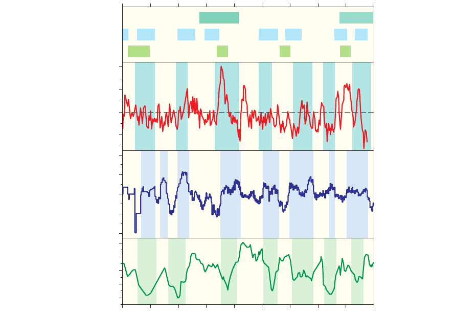
Latitudinal linkages of millennial-scale hydrologic events during the middle to
late Holocene are less evident because of poor chronologic control on North
Atlantic cold events 0 to 4 as originally defined (Figures 8.10 and 8.13b; Bond et al.
2001) and their uncertain relationship to millennial-scale variability in the
Greenland ice-core record (Figure 8.13a; O’Brien et al. 1995). By comparison, the
events of weak Indian and Asian monsoon activity that supposedly are dynamically
related to the North Atlantic cold events are much better constrained chronolo-
gically (Wang et al. 2005; Figures 8.10a and 8.13c), except that the Dongge Cave
speleothem record does not give strong evidence of weak Asian monsoon events
coincident with the LIA (event 0) and the Dark Ages cold episode (1800–1400
years BP; event 1). Wang et al. (2005) also confirmed the significant influence of
small (< 1 percent) variations in century-scale solar output on Asian monsoon
intensity, a sun–climate connection that was previously hinted at by many less
well-dated climate proxy records tuned to the atmospheric Δ
14
C record of solar
forcing. These included the original record of a 1500-year quasi-cycle in ice rafting
on the North Atlantic Ocean (Bond et al. 2001), mass balance of Scandinavian
glaciers (Denton and Karlén 1973), temperature (Heiri et al. 2004) and lake-level
variations (Magny 2004; Figures 8.3 and 8.13e) in central Europe, and Indian
monsoon intensity in the Arabian Sea (Agnihotri et al. 2002; Gupta et al. 2003,
2005) and on adjacent land areas (Neff et al. 2001; Fleitmann et al. 2003). Modeling
studies indicate that the reported millennial-scale climate anomalies are caused by
beat modulation of the century-scale periodicity in solar output (Clemens 2005;
see also Braun et al. 2005).
In equatorial Africa, Russell and Johnson (2005a) found temporal correlation
between drought in central equatorial Africa and both cold and warm extremes in
the North Atlantic 1500-year cycle, when employing the derivative of their 5400-
year Lake Edward percent Mg record (see above) as principal indicator of African
moisture balance. These authors proposed that the reconstructed average drought
recurrence time of 750 years results because either southward or northward dis-
placement of the ITCZ from its mean position during cold or warm events in the
North Atlantic would have starved the equatorial region of its normal share of
..
9781405159050_4_008.qxd 6/3/08 3:58 PM Page 217
..
218
|
Dirk Verschuren and Dan J. Charman
..
rainfall. Holocene climate variability at similar ca. 700-year intervals has also been
reported from the Indian Ocean (von Rad et al. 1999; Staubwasser et al. 2003), and
attributed to solar forcing. Even so, the direct effect of solar forcing on tropical
temperature and rainfall is probably much smaller than its indirect effect through
amplifying processes in high-latitude regions, for example, forced shifts of the
North Atlantic Ocean to a predominantly high or low AO/NAO index state
(Shindell et al. 2001). In an earlier analysis of the high-resolution Lake Edward
% Mg in calcite
(anomaly)
Water table
(SD units)
Residual
14
C
–2
4
2
0
–2
–4
–1
0
1
2
–10
0
10
20
(c)
(d–e)
(f)
(g)
(b)
(a)
05001000150020002500300035004000
Years BP
4500
3210
32 1 0
Figure 8.13 Timing of century-scale moisture-balance
reconstructions in northwest Europe and tropical Africa
in relation to atmospheric Δ
14
C as proxy of solar activity
variation and proxy records from elsewhere. (a) Holocene
cold events in Greenland (from O’Brien et al. 1995).
(b) Ice-rafting events in the North Atlantic Ocean (from
Bond et al. 2001). (c) Episodes of weakened Asian
monsoon (from Wang et al. (2005)). (d) Lake highstand
episodes in west-central Europe (blue shaded bars) in
relation to (e) atmospheric Δ
14
C variation (from Magny
(2004)). (f ) Northern British peatland surface wetness,
with inferred wet episodes highlighted (from Charman
et al. 2006). (g) Percent Mg in authigenic calcite from
Lake Edward (western Uganda) with inferred dry
episodes highlighted (from Russell and Johnson
(2005)).
9781405159050_4_008.qxd 6/3/08 3:58 PM Page 218

Latitudinal linkages in moisture-balance variation
|
219
..
record, Russell and Johnson (2005b) had found no direct correlation with the
atmospheric Δ
14
C record of solar forcing. The most prominent Δ
14
C anomaly of
the late Holocene, at 2800–2600 years BP, corresponds with prolonged drought
both in central Africa and tropical West Africa, but the most prominent central
African drought of the late Holocene, at 2050–1850 years BP, occurred in a time of
rather stable solar output (Figure 8.13g). Van Geel et al. (1998) pointed to the
synchrony of the 2800–2600 years BP drought in Cameroon with the prominent
shift to a cooler, wetter climate in north-temperate Europe (Figure 8.4) to associate
both with reduced solar activity at that time (cf. Beer and van Geel, this volume).
Looking at all proxy records of hydrologic change, a solar influence on central
European lake levels (Magny 2004) and British peat surface wetness (Charman et al.
2006) during the late Holocene is evident but not strong. Coincidence of central
African drought with phases of high surface wetness in British peatlands is high,
however, throughout the past 4500 years (Figure 8.13f and g), suggesting a rather
direct connection between these two regions in the climate processes modulating
century-scale climate variability. One possibility is that variability in North
Atlantic sea-ice extent, through its influence on ocean thermohaline circulation
and cross-equatorial heat transport, creates sustained changes in mean annual
ITCZ position (Vellinga and Wood 2002; Lohmann 2003; Li et al. 2005). When
during cold events in the North Atlantic moisture advection onto the European
continent is enhanced and the ITCZ assumes a more southerly position, westerly
winds may not penetrate as far eastward into Africa (McHugh 2004) and poten-
tially cause drought in the westernmost portions of East Africa that partly depend
on this Atlantic moisture (Russell et al. 2007).
Conclusions
Marked regional correspondence exists both within and between high and low
latitude regions in Holocene moisture-balance changes at millennial and century
time-scales. Apparent regional variation in the principal Holocene trends of
monsoon intensity across the Northern Hemisphere sub-tropics, from a gradual
response to precessional insolation forcing to a succession of millennial-scale cli-
mate swings, must have both a real regional climate component and a component
dependent on the archive or proxy indicator recording the climate change.
Consistent century-scale water-table changes in north-west Europe reconstructed
from peatlands have occurred in synchrony with lake-level changes in west-central
Europe, and somewhat less clearly with mass balance changes of Alpine glaciers.
The relative magnitude of individual events is archive-dependent and regionally
diverse. Some episodes of high lake level and aquifers (at ca. 3400, 2750, 1250, and
700 years BP) and inferred cool weather correspond to periods of reduced solar
activity, suggesting a causative link. The anomalies are not proportional to the
proposed forcing, however, and some hydrologic events have no equivalent in
the record of solar activity. Records from Iceland to tropical Africa reveal a
..
9781405159050_4_008.qxd 6/3/08 3:58 PM Page 219