Caers J. Modeling Uncertainty in the Earth Sciences
Подождите немного. Документ загружается.

P1: OTA/XYZ P2: ABC
JWST061-07 JWST061-Caers April 6, 2011 13:20 Printer Name: Yet to Come
FURTHER READING 131
image). In other words, one may end up generating an inverse solution m that is not even
part of the initial prior set, hence violating Bayes’ rule as explained above. It should also
be realized that simply obtaining many solutions to an inverse problem does not entail
that one has a realistic model of uncertainty. One could, for example, apply the same
optimization algorithm with different initial starting models, then observe that multiple
different solutions are obtained from these different starting points. This observation only
shows that there are many solutions, however these solutions do not necessarily (actually
rarely) represent a realistic model of uncertainty under the auspices of Bayes’ rule.
In this book, on modeling uncertainty, prior information is considered highly valuable,
particularly if there is large uncertainty on parameters that are sensitive to a decision
problem. If there is only small uncertainty, then models of uncertainty may not be relevant
to solving the problem in the first place. In that case, optimization methods are preferred.
Further Reading
Dubrule, O. (2003) Geostatistics for seismic data integration in Earth models. SEG 2003 Distinguished
Instructors Short Course.
Strebelle, S., Payrazyan, K., and Caers, J. (2003) Modeling of a deepwater turbidite reservoir conditional
to seismic data using multiple-point geostatistics. SPE Journal, 8(3), 227–235.
Tarantola, A. (2005) Inverse Problem Theory and Method for Model Parameter Estimation,SIAM
publications.
P1: OTA/XYZ P2: ABC
JWST061-07 JWST061-Caers April 6, 2011 13:20 Printer Name: Yet to Come
P1: OTA/XYZ P2: ABC
JWST061-08 JWST061-Caers March 29, 2011 10:31 Printer Name: Yet to Come
8
Modeling Structural Uncertainty
Co-authored by Guillaume Caumon
Nancy School of Geology, France
Uncertainty modeling being the main topic in this book brings us to the evident question: how
to build multiple structural models that serve as a representation or model of uncertainty?
This is not as trivial a question as the modeling of properties on a regular grid. The various
constraints of geological consistency as well as the difficulty of automating the construction
of structural models make this a difficult task.
Physical
model
Spaal
Stochasc
model
Spaal
Input
parameters
Forecast
and
decision
model
Physical
input
parameters
Raw
observaons
Data sets
response
uncertain
uncertain
uncertain certain or uncertain
uncertain/error
uncertain
uncertain
8.1 Introduction
Previous chapters dealt with the spatial modeling of properties/variables that can be rep-
resented on a simple Cartesian grid. Various models of spatial continuity that are used
Modeling Uncertainty in the Earth Sciences, First Edition. Jef Caers.
© 2011 John Wiley & Sons, Ltd. Published 2011 by John Wiley & Sons, Ltd.
133
P1: OTA/XYZ P2: ABC
JWST061-08 JWST061-Caers March 29, 2011 10:31 Printer Name: Yet to Come
134 CH 8 MODELING STRUCTURAL UNCERTAINTY
in generating several alternative Earth Models, potentially constrained to data, were pre-
sented. What was ignored is the structural framework and grid needed to simulate these
properties on. In some cases, the framework is a simple grid, surface or volume, for ex-
ample a grid representing the layers in the Earth’s atmosphere. However, in many cases,
particularly in modeling the subsurface, the structure modeled can be quite complex (see
Figure 8.1) and requires subdividing the domain of interest into units based on geological
considerations (setup process, age, rock type). These units are bounded by 3D surfaces
such as faults and horizons, which can be modeled from the observations at hand, then
serve as a structural framework to create a conforming grid. In addition, one may want
to model the change of these surfaces over geological history, hence a change in the grid
over time.
The representation of the structural framework appeals to classical CAD techniques
such as parametric lines and surfaces and/or meshes. In addition, modeling of geological
surfaces relies on specific methods to honor typical subsurface data types and guarantee
the consistency of the model with geological processes.
When it comes to modeling geological surfaces and considering the related uncer-
tainty, it is important to distinguish between the three following characteristics:
1 The topology, which describes the type of surface (spherical, donut-shaped, open, with
hole(s), etc.), and the connectivity between surfaces, for instance the termination of
a fault onto another fault. The topology of an object does not change (it is invariant)
when the object undergoes a continuous deformation (Figure 8.2).
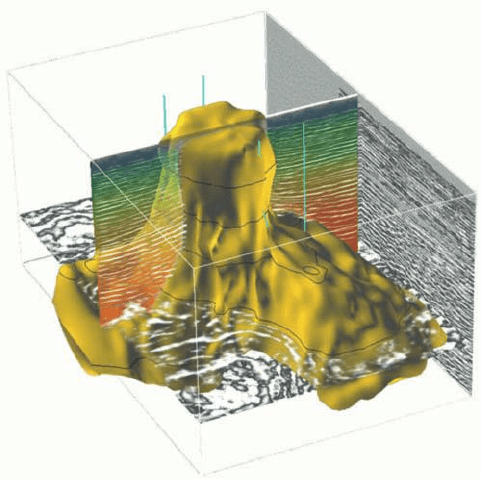
Figure 8.1 Complex structure (salt dome) interpreted from seismic data.
P1: OTA/XYZ P2: ABC
JWST061-08 JWST061-Caers March 29, 2011 10:31 Printer Name: Yet to Come
8.2 DATA FOR STRUCTURAL MODELING IN THE SUBSURFACE 135
Smal
l
fault
throw
Larg
e
fault
throw
Thin
,
deep
layer
Thick
,
shallow
layer
Con
nuou
s
geometri
c
deformaon
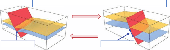
Figure 8.2 Two geological surface models having different geometry but the same topological
features (number of surfaces and adjacency between those).
2 The geometry, which specifies the 3D position and shape of the surface in space. In a
numerical earth model, it is generally given by the location of some nodes and by an
interpolation method between nodes (linear, spline, etc.).
3 The properties, or attributes, attached to the object. These can be rock properties
(porosity, soil type, etc.), physical variables (temperature and pressure) or geometri-
cal properties (e.g., local slope or curvature).
This chapter concentrates on building structural models for the subsurface (local or
global scale) and dealing with uncertainty related to geological structures. Because un-
certainty about properties has been considered in previous chapters, the focus is mostly on
uncertainty related to the geometry and to the topology of structural models. So this chap-
ter is quite specific to the data and problems related to modeling the subsurface; however,
other Earth Science applications could be envisioned with these techniques, for example
classification of fossils or mapping the Earth surface from remote sensing data. The goal
of this chapter is not to provide a detailed perspective on building structural models, but
to introduce and categorize those elements of structural modeling that are most subject to
uncertainty, hence play a key role in modeling uncertainty in 3D Earth models.
8.2 Data for Structural Modeling in the Subsurface
Data most used for structural modeling are geophysical images obtained through geo-
physical surveys such as seismic surveys (Figure 8.3) or EM (electromagnetic surveys).
These can be ground based or airborne, even using satellites (synthetic aperture radar
data) for example to detect ground movement.
Geophysical data provide a complete coverage of the subsurface along one section
(e.g., 2D seismic) or over a whole volume (e.g., 3D seismic). The geophysical data used
are the outcome of a complex chain of geophysical processing. For example, seismic
acquisition is based on the emission of an artificial vibration (the source) either onshore
or offshore (Figure 8.3), whose echoes are recorded by a set of geophones. The seismic
waves emitted by the source undergo refraction and reflection when propagating through
P1: OTA/XYZ P2: ABC
JWST061-08 JWST061-Caers March 29, 2011 10:31 Printer Name: Yet to Come
136 CH 8 MODELING STRUCTURAL UNCERTAINTY
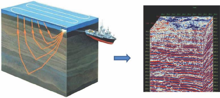
Figure 8.3 Configuration of sources and receivers in a marine seismic survey (left). The resulting
3D processed seismic data cube on which interpretations are made (right).
rocks of different nature. This signal carries the contrasts of impedance (the product of
seismic wave velocity by the rock density) as a function of time (the travel time between
the source and the geophone). Seismic processing turns the raw data into a useable 3D
seismic image, as shown in Figure 8.3.
The processing of seismic data is very complex and computationally very demanding,
requiring a number of corrections and filtering operations, whose parameters are gener-
ally inferred from the raw seismic data and calibrated at wells. For example, the con-
version of travel times to depth is ambiguous, since it requires an estimation of seismic
velocities which are not known a priori. Therefore, seismic data are not precise, espe-
cially in the vertical direction. Also, they have a poor resolution (from a few meters for
shallow, high resolution seismic to about 20–50 meters for classical surveys). Lastly, the
significance of seismic images decreases as depth increases, due to the attenuation of the
signal amplitude. Notwithstanding these limitations, the value of seismic data is its ability
to cover an entire volume. The fuzzy picture provided by seismic is of paramount impor-
tance for structural modeling, as it provides a view of 3D geometries. Seismic amplitudes
are routinely used to extract significant surfaces such as horizons, unconformities, faults,
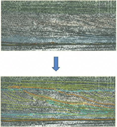
and so on (Figure 8.4). As the seismic image is fuzzy, such extraction requires tedious
interpretation through manual picking. In other words, an interpreter sits for hours in
front of a computer screen using software to pick points that he/she thinks correspond to
geologic features. These points will then help create surfaces and eventually a structural
framework.
8.3 Modeling a Geological Surface
The typical input for structural modeling is a set of samples in 3D that represents the
most likely locations where the surface exists. Before considering how uncertainty can be
P1: OTA/XYZ P2: ABC
JWST061-08 JWST061-Caers March 29, 2011 10:31 Printer Name: Yet to Come
8.3 MODELING A GEOLOGICAL SURFACE 137
Figure 8.4 A 2D slice from a 3D seismic data cube and its interpretation by an expert.
addressed, we will first provide some details about how to represent a possible structural
model constrained to these data.
A structural model is an idealization of the main rock boundaries, generally repre-
sented by a discrete set for each surface. For example, a continuous surface is often
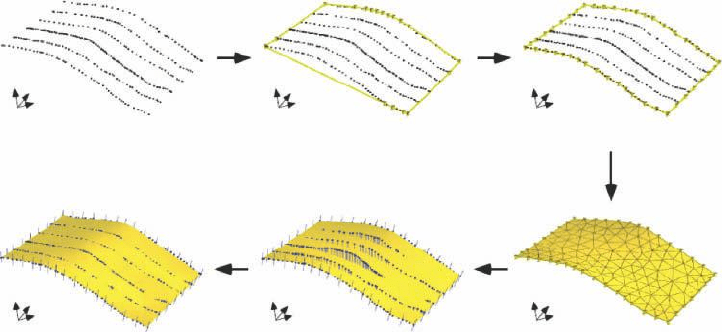
approximated by a set of planar polygons forming a 2D mesh in 3D space. The creation
of one surface from interpretation points goes through several steps, summarized by
Figure 8.5:
A Establish the point set to work with.
B-C Determine the lateral extent of the surface, for instance take the convex hull of the
data points (imagine an elastic band stretching around the data points), or simply
take the intersection of the average plane with the domain of study.
D Create a first surface model from the points outline and/or the average plane, with a
specific level of detail
E-F Deform it to make it closer to the data.
Although these steps are often automated by software, there are two main modeling
decisions to be made during this workflow which are prone to uncertainty. Firstly, the
P1: OTA/XYZ P2: ABC
JWST061-08 JWST061-Caers March 29, 2011 10:31 Printer Name: Yet to Come
138 CH 8 MODELING STRUCTURAL UNCERTAINTY
(a) (b) (c)
(f) (e) (d)
Figure 8.5 Fitting a surface to a set of points.
resolution of the surface tells how much geometric detail may be represented in the final
surface. Ideally, a model should have a minimal size to reflect the available data with-
out loss of information (e.g., few triangles and points in at smoothly varying areas, and
high densities in high curvature areas). However, it often makes sense to smooth out high
resolution details considered as noise by choosing a surface resolution coarser than the
interval between data. Secondly, away from the points, the surface is generally set to be
smooth, to reflect the principle of minimum energy (or second law of thermodynamics)
during rock deformation and rupture when the rocks are buried in the subsurface. The
balance between smoothness and data fitting can be controlled by the modeler, convey-
ing how much one trusts interpretation points versus simplified physical principles. The
resolution and degree of smoothness of the resulting surface are both contributing to the
uncertainty about the structural model.
8.4 Constructing a Structural Model
Discontinuities within the subsurface are due to changes of depositional conditions, ero-
sion, tectonic events such as faulting and folding or late transport of reactive fluids. Pre-
viously, ways to create 3D surfaces to represent the 3D geometry of discontinuities, for
example, horizons and faults were described. In constructing a structural model, we can
no longer deal with surfaces one at a time, but need to consider how they are related to
each other. Modeling correctly the relationships between geological surfaces is critical to
ensure the consistency of a numerical model as formulated by geological validity condi-
tions and a set of geometrical and topological constraints to enforce these conditions.
8.4.1 Geological Constraints and Consistency
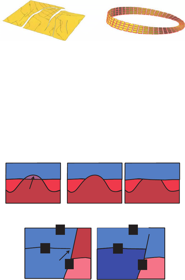
Numerical modeling of 3D objects can produce shapes which are mathematically correct
but do not represent any valid natural object (Figure 8.6). Since Earth data are often sparse
P1: OTA/XYZ P2: ABC
JWST061-08 JWST061-Caers March 29, 2011 10:31 Printer Name: Yet to Come
8.4 CONSTRUCTING A STRUCTURAL MODEL 139
A possible geological surface
A surface that does not occur in nature
Figure 8.6 An orientable and non-orientable surface (Moebius ring).
and noisy, 3D modeling relies on automatic and interactive consistency checks such that
valid structural models are generated.
Previously, the creation of surfaces constrained to point sets in three dimensions was
presented. These data points often mark the common boundary of two volumes of dif-
ferent nature, for example a contrast of a certain property or the existence of a certain
discontinuity. As such, a geological interface can be seen as a magnet whose sides have a
different polarization. Such a surface with two well defined sides is said to be orientable.
A famous example of non-orientable surface is the Moebius ribbon depicted in Figure
8.6; it cannot be created by a natural process.
Each side of a surface bounds a particular layer or (fault) block. For volume consis-
tency, a surface must not self-intersect. More generally, the volumes defined by a set of
interfaces must not overlap. For instance, the hatched part in Figure 8.7 would belong
H
F
H
B
F
Not valid ValidValid
Not valid Valid
problem
problem
B
Figure 8.7 Valid and non-valid configuration of faults and horizons in the subsurface.
P1: OTA/XYZ P2: ABC
JWST061-08 JWST061-Caers March 29, 2011 10:31 Printer Name: Yet to Come
140 CH 8 MODELING STRUCTURAL UNCERTAINTY
to both layers, which does not make any geological sense. The succession of geologi-
cal processes imposes a hierarchy on the geological objects. One consequence is that an
interface between two rock volumes is necessarily bounded by other interfaces. For in-
stance, a surface representing a horizon cannot float in space: its borders have to lie on
other natural surfaces, such as a fault or domain boundary surface. The only exception to
that rule is faults: the borders of a fault surface can float in space. This corresponds to a
so-called “null throw” (Figure 8.7).
The criteria defined above are only necessary conditions for enforcing geological va-
lidity. Defining sufficient conditions is much more difficult and calls for higher level con-
cepts in structural geology and sedimentology. Enforcing such conditions intrinsically in
the model building process is neither always easy nor applicable, and requires a care-
ful prior geological analysis of the domain being studied. Alternatively, models can be
checked for consistency with some type of data or physical principles. This a posteriori
check is usually computationally expensive.
8.4.2 Building the Structural Model
Given our knowledge about construction of a surface and the various conditions required
to build a consistent structural model, the following basic steps can be used to build such
model (Figure 8.8):
A Collecting a data set on fault and horizon surface (such as based on interpretation of
seismic data).
B Creating fault surfaces from data points, each independently.
C Connecting the faults properly accounting for the geological consistency rules above.
Significant uncertainty is present at this stage, because subsurface data seldom provide
a clear image close to discontinuities. It is up to the modeler, based on analog reason-
ing and careful data analysis (e.g., regional tectonic history, hydraulic connectivity
between wells, etc.), to decide on the fault connection patterns.
D Constructing horizon surfaces from data points.
E Cookie-cutting the horizons by the fault network and updating the horizon geometry
inside each fault block.
F Merging fault and horizon surfaces.
The logic behind these steps follows the genetic rules of most subsurface structures,
that is, horizons (layers) were created first, and only then were these layers deformed and
faults created. Hence faults are assumed younger in time and should be constructed first.