Gates A.E., Ritchie D. Encyclopedia of Earthquakes and Volcanoes
Подождите немного. Документ загружается.

volcano is located across the Atlantic Ocean, quite a dis-
tance from the east coast of the United States, making it an
unlikely threat. But since the teletsunami that generated in
Banda Aceh killed people across the Indian Ocean, anything
is possible. During Cumbre Vieja’s eruption in 1949, the west-
ern flank of the volcano began a slow collapse. It slid farther
during the 1971 eruption, to a precarious position. Research-
ers speculate that this flank may collapse during a subsequent
eruption, causing a catastrophic landslide into the Atlantic
Ocean. This landslide could act like the surface-to-water land-
slide that occurred in Lityua Bay in Alaska, which generated
a huge seiche that climbed 1,700 feet (510 m) up the facing
shore. They project that a wall of water some 300 feet (90 m)
high could race across the Atlantic Ocean and devastate the
east coast, the Caribbean Sea, and even West Africa. Cer-
tainly, if such a scenario were to occur, the death and destruc-
tion would make Banda Aceh look small. On the other hand,
the Canary Islands have been in existence for many million of
years, and there is no evidence of the Atlantic seaboard ever
having been hit by any wave of such size.
62 Cumbre Vieja
dacite An intermediate volcanic rock, dacite is more
quartz-rich than andesite. It is also less potassium-rich
than rhyolite. They are typically fine-grained, but pheno-
crysts (large grains) include feldspars, biotite, and horn-
blende. Ironically, dacite is the most common rock in
eruptions along the continental side of subduction zones
between oceanic and continental crustal plates. These bound-
aries are also called Andean Margins. Even though andesite
is named for the Andes Mountains, most of the volcanic
rocks there are dacites.
Daisetsu-Tokachi graben, Japan Now mostly filled, the
Daisetsu-Tokachi graben is a large depression on the island
of Hokkaido¯. Several volcanic domes (Ushiorasahi-dake,
Kuma-dake, Hokuchin-dake, Ryon-dake, Keigetsu-dake,
Kuro-dake, Eboshi-dake, and Hakuun-dake) are found in the
vicinity and are thought to occupy points along the rim of
a buried Daisetsu caldera. The volcano Tokachi-dake occu-
pies the south end of the graben. It has produced 17 clustered
historic eruptions in 1670, 1857, 1887–89, 1925–31, 1952–
62, and 1985–89. Tokachi-dake was active in the 1920s,
starting with increased emissions of steam and other gases in
1923. Also in 1923, a solfatara near the rim of the crater
was replaced by a pool of either boiling water or melted sul-
fur. A hot spring near the crater also exhibited a dramatic
rise in temperature.
Activity at the volcano, including minor explosions,
continued through late 1925 and early 1926, and a fairly
strong explosion took place on April 5. By early May, minor
earthquakes were occurring. An explosion and mudflow
were observed on May 24, followed later that day by a more
powerful explosion, another mudflow and a landslide. The
mudflows or lahars moved down the Hurano valley 12
miles (20 km) in 26 minutes. They destroyed 5,080 homes
and killed at least 146 people. A strong earthquake on Sep-
tember 5 preceded another eruption by three days. Activity
then diminished at the volcano, and by 1928 the only signs
of continued volcanism were changes from time to time in the
output of fumaroles in the crater of Tokachi-dake.
fumaroles became notably more active in August 1952
when a new crater, called Showa, formed and continued
puffing for the next seven years. A strong earthquake off
the coast of Hokkaido in 1962 preceded a large increase in
fumarolic activity at the crater. Temperatures of fumaroles
rose for about two months afterward. Earthquakes became
more frequent in the vicinity of the volcano, and rockfalls
occurred along the east wall of the crater in late April and
in May. Five people were killed by the rockfalls. Steaming
and rumbling increased sharply on May 30, and numerous
earthquakes occurred on May 31. Muddy hot water emerged
from fumaroles on the northwest side of the central cone on
June 29. Seismic and fumarolic activity then diminished until
about midnight, when a large explosion took place. By late
August, earthquake activity had dropped again to its normal
level.
A very strong tectonic earthquake on May 16, 1968,
almost 200 miles (322 km) from Tokachi, appears to have
touched off renewed activity at the volcano. Just after the
tectonic earthquake, a swarm of earthquakes occurred at
Tokachi-dake. This activity diminished for a few months but
intensified again in December 1968 and reached maximum
activity in January and March 1969. The swarm of activity
included several thousand recorded volcanic earthquakes.
No eruption, however, occurred at this time. Small eruptions
occurred in June 1985.
Dakataua caldera, Papua New Guinea The Dakataua
caldera is situated on the Talasea Peninsula on the northern
shore of New Britain Island. The caldera is thought to have
formed only about 1,150 years ago. Inside the caldera is a
central volcano, Mount Makalia, that contains a crater lake
more than 300 feet (91 m) deep. Eruptions have occurred
from ring fractures in the caldera. lava flowed from the
summit in an eruption about the year 1890. Warm springs
D
63
exist at the base of Mount Makalia, and a cinder cone in the
summit crater emits steam.
Damghan earthquake, Iran On December 22 a.d. 856,
one of the greatest natural disasters of all time occurred. A
massive earthquake struck Iran in the province of Fars and
in the region of Qumes, especially in the city of Damghan.
The quake was felt as far away as Syria and Yemen. Appar-
ently, this was a very seismically active period in this
region because there are reports of numerous earthquakes
for several years before this. The number and intensity
increased toward the end of 856, when strong earthquakes
were reported from December 3 to the real main shock on
December 22. There are reports of great fissures in which
people were consumed, avalanches in the mountains, sur-
face ruptures, and heavily flowing springs that switched to
bone-dry and back on a daily basis. In all, some 70 towns
were destroyed. According to the U.S. Geological Survey,
some 200,000 people lost their lives in this event, making it
among the most devastating. Other sources list the Decem-
ber 22 event as having killed 48,690 people in Khoresan. It
is unclear whether 200,000 were killed in the month or by
the single event.
This was not the first report of a massive earthquake
destroying Damghan. There was a massive earthquake in a.d.
662 that laid waste to the city. It reportedly killed some 40,000
people, but details are few. Damghan is an area of historical
seismic activity that periodically produces a record disaster.
damping Damping is the loss of energy (and amplitude)
in a moving wave as it passes through a medium by fric-
tional forces. The friction converts the seismic energy into
heat energy. The different rock and soil types cause differ-
ing amounts of damping of the seismic waves as they pass
through.
dams Artificial and natural dams can present potential
hazards during earthquakes and volcanic eruptions. Waters
impounded behind a dam can be released with devastating
effect if the dam should fail, or landslides or other phenom-
ena could raise the water level above the dam, sending water
rushing along the valley downstream.
In the 1971 San Fernando earthquake in southern
California, for example, the Upper and Lower Van Nor-
man Dams sustained severe damage. The Lower Van Nor-
man Dam appears to have come close to failing. Most of
the damage to the Lower Van Norman Dam consisted of a
slope failure that dislodged a huge segment of the earth-fill
embankment and sent it to the floor of the reservoir. The
slide removed the dam’s upstream concrete lining and crest,
and one of two intake towers was destroyed. Discharge facili-
ties at the Lower Van Norman Dam were opened to lower
the water level behind the dam, and the area below the dam
was evacuated for several days after the earthquake while
water was drained from the reservoir. The Upper Van Nor-
man Dam’s crest sagged considerably, and the dam itself
shifted about 6 feet (1.8 km) downstream.
Volcanic eruptions also contain a potential for catas-
trophes involving dams when an eruption occurs nearby.
The 1980 eruption of Mount Saint Helens, for example,
occurred only several miles from Swift Reservoir. Had the
tremendous avalanche of debris from the eruption moved
south toward the reservoir, instead of north and east, it might
have overwhelmed the reservoir and resulted in the flood-
ing of the lower valley of the Lewis River, a tributary of the
Columbia River. Following the eruption, two debris dams in
the Toutle and Cowlitz river systems were studied for their
flood hazards. One of the dams failed the day after the theo-
retical failure analysis was carried out, and the hypothetical
results agreed closely with the actual results.
Dasht-e Bayaz earthquake, Iran A massive earthquake
struck Dasht-e Bayaz in the northeastern province of Kho-
rassan, Iran, on August 31, 1968. The magnitude of the
main shock was 7.2 on the Richter scale, with a relatively
shallow focus of less than nine miles (15 km) in depth. The
maximum modified Mercalli intensity was X, occurring
over a 30-mile (50-km) length. It was felt over an area of
about 39,000 square miles (100,000 km
2
). The main after-
shock occurred on September 1 at 6.4 magnitude, but dur-
ing the following six weeks, there were nine aftershocks
with magnitudes between 5.0 and 5.6 among the hundreds
of smaller events. The fault that generated this series of
events experienced left-lateral strike-slip displacement of
up to 15 feet (4.5 m) along 48 miles (80 km). Offset ridges,
streams, and other features show this displacement.
Between 7,000 and 12,000 people were killed by the
earthquake. Poor records and insufficient accounting are
the reason that this number is so inexact. At least 12,000
houses were destroyed, leaving over 70,000 people home-
less. The reason for the massive destruction and loss of life
was primarily the shoddy construction of buildings and nar-
row streets. In order to prevent disease, bodies were quickly
buried in a mass grave. In addition to the aid provided by
Iran, Great Britain and Turkey were instrumental in relief
efforts.
dead fault Basically, an inactive fault. A dead fault is
typically declared to have no chance of activity, whereas an
inactive fault may become reactivated. However, declaring
a fault incapable of producing earthquakes is a good way to
risk having to eat one’s words in a serious situation.
death toll There are horrifying death tolls reported for
most of the earthquakes and volcanoes in this book. When
the numbers are low, the death toll can be considered rela-
tively accurate. Large events may not be so accurate because
multiple sources must be tallied, and there is a lot of room
for error. In the distant past, no one had time to count all of
the bodies during a disaster, so the numbers tended to be very
imprecise and could be in error by as much as an order of
magnitude. More recent geologic events have had more accu-
rate death tolls, but still have room for improvement. With
inland earthquakes, where rescue and relief efforts are done
properly, the numbers are usually accurate because bodies
remain despite widespread destruction. With coastal earth-
quakes that spawn tsunamis, there are often errors due to
lack of evidence (bodies, buildings, and records swept out to
64 Damghan
sea). Volcanic eruptions can be equally inaccurate due to the
severe destruction caused by the eruptions and lava flows.
Translations from other languages may also lead to errors
that can then wind up throughout the literature. For exam-
ple, one of the worst earthquake disasters on record occurred
in China in the 1920s. Records have a death toll of 200,000.
A new, more reliable source states that 200,000 livestock
perished in this event but only 35,000 people. Death tolls
may also be exaggerated by officials for political reasons. The
great Tangshan earthquake in China had an official death
toll of 249,000 people, but many scientists believe that it may
have been closer to 655,000. The communist government at
the time did not want to appear weak to its enemies and so
reported a deflated death toll. On the other hand, when there
is a lot of international aid available, some governments will
inflate the numbers to get more money.
Death Valley California, United States Death Valley—site
of Death Valley National Monument—is famous for having
the lowest point in North America, the Badwater Depres-
sion, 282 feet (86 m) below sea level. Death Valley is part
of the Basin and Range Province of the western United
States and shows abundant evidence of volcanic activity.
Death Valley represents a block of crustal rock that is sink-
ing so rapidly that erosion from surrounding areas cannot fill
it fast enough to keep up with its descent. Some of the most
recent volcanic activity in Death Valley is thought to have
occurred several thousand years ago in the vicinity of Ube-
hebe Crater. About a half-mile wide, Ubehebe Crater appears
to have originated in a phreatic eruption in which a giant
blast of steam followed contact between groundwater and
magma below the surface. Near the Black Mountains, the
action of heated water on deposits of rhyolitic ash has cre-
ated a spectacular display of colors.
Debal earthquake, Pakistan There are historical accounts
of a devastating earthquake that struck the Indus delta in
present-day Sindh, Pakistan, near the city of Debal. Records
are incomplete, but the event was recorded as having taken
place between March 13, a.d. 893, and December 14, 894.
Based upon the density of sand blows identified for this event
compared to that from the nearby Gujerat (Bhuj) event of
2001, the Richter magnitude of this event was estimated at
7.5. Historical documents state that the earthquake occurred
at night, causing massive damage to the town of Debal. Only
100 buildings were left standing. Archaeological excavations
of the area revealed human remains crushed in doorways and
crouched in corners. There was even a case of a brick embed-
ded in a human skull. All of the evidence pointed toward a
huge disaster, and the death toll was estimated as high as
150,000 people, making it one of the worst ever. Other his-
torical documents pointed toward a great shift in power in
the area and the abandonment of several cities near Debal.
Geological studies indicated that the Indus and Nara Rivers
abruptly shifted course to the west about this time, which
might be consistent with a very large earthquake. The shift
caused flooding and the abandonment of several major sea-
ports on the river. It is interesting that this earthquake was
approximately the same time as the Ardabil, Iran, earth-
quake, which was also reported to have killed 100,000 to
180,000 people.
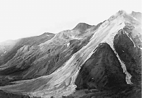
debris avalanche Avalanches are rapidly moving diffuse
bodies of material on steep mountain slopes. They can be pre-
dominantly composed of snow (snow avalanche) or a mixture
of materials such as soil, rocks, trees, ice, and other items
all constituting debris. Debris avalanches are a type of mass
movement characterized by velocities between 33.5 and 335
feet (10 and 100 m) per second. They originate on mountain
slopes that collapse by any of a variety of mechanisms (earth-
quakes and volcanoes are the most common). The movement
history can include a period of free fall, during which time
the mass of debris can attain high velocities and travel long
distances. The movement of the debris can generate strong
wind by pushing air out of the way. These winds can be of
hurricane force. Debris avalanches are devastating to all life
that stands in their path. The scars left by debris avalanches
are shaped like long narrow funnels. The trough-like chutes
they leave look smooth from a distance but are usually pock-
marked from the bouncing boulders.
debris flow A moving mass of rock, soil, and organic
material where more than half of the particles are larger than
sand. Debris flows are included as landslides and can move
as slowly as feet per year to as quickly as hundreds of miles
per hour. Earthquakes and volcanoes can trigger debris flows,
but they are typically of the avalanche variety.
debris slide Debris slides are masses of unconsolidated
surficial material that break loose and slide down a sloped,
underlying bedrock surface. They are a type of mass wast-
ing. Both debris slides and rockslides slip on an existing
slide plane, such as a bedding plane or a fault plane. Debris
slides are most common where thin layers of unconsolidated
material mantle slope and becomes water saturated. They can
A debris avalanche is a very rapid mass movement down a steep slope.
This debris avalanche flowed down a 1,500-foot (457-m) peak on the
peninsula between Ugak and Kiliuda Bays, Alaska. Notice small overflow
channels along the side of the slope. (Courtesy of the USGS)
debris slide 65
then slip on the rock surface. Earthquakes can generate debris
slides, and debris slides are common on the slopes of volca-
noes where layers of ash can break free and slide.
decade volcanoes The major contribution of the Inter-
national Association of Volcanology and Chemistry of the
Earth’s Interior (IAVCEI) to the International Decade for
Natural Disaster Reduction (1990s) was the designation of
decade volcanoes. The goal of IAVCEI’s decade volcano proj-
ect was to draw attention to a small group of active volca-
noes and encourage a range of research and public awareness
activities to enhance literacy on volcanoes and the hazards
they pose. The following 16 volcanoes have been officially
designated as decade volcanoes:
1. Avachinsky-Koryaksky, Kamchatka
2. Colima volcano, Mexico
3. Mount Etna, Italy
4. Galeras volcano, Columbia
5. Mauna Loa, Hawaii
6. Merapi volcano, Indonesia
7. Niragongo volcano, Republic of Congo
8. Mount Ranier, Washington
9. Sakurajima volcano, Japan
10. Santa Maria/Santiaguito volcano, Guatemala
11. Santorini volcano, Greece
12. Taal volcano, Philippines
13. Teide volcano, Canary Islands
14. Ulawun volcano, Papua New Guinea
15. Unzen volcano, Japan
16. Mount Vesuvius, Italy
Deccan Plateau India The Deccan Plateau is made up of
flood basalts and is comparable in form in many ways to
the volcanic Columbia Plateau and Snake River Plain
of the northwestern United States, but it is much larger. The
Deccan Plateau was formed during the breakup of Pangaea
during the Cretaceous period. It is part of the early stages
of the development of a divergent boundary. One theory
is that this extensive volcanism is responsible for the mass
extinction that included the demise of the dinosaurs. With the
other contemporaneous flood basalts (Pirana and Karoo), this
time was one of the most volcanically active periods in the
last 500 million years. One theory suspects the Deccan Pla-
teau and related volcanism of being an impact structure, cre-
ated when a planetoid struck Earth’s surface and generated a
hot spot that produced large flows of extrusive rock.
Deception Island South Shetland Islands, United King-
dom A spectacular caldera in the middle of Deception
Island (located near the Antarctic Peninsula) is thought to
have been formed by tremendous eruptions of andesite.
Many vents are active along ring dikes (fractures) near
the harbor. Records of eruptions at Deception Island before
very recent times are probably incomplete because the island
has no permanent settlements. When HMS Chanticleer
stopped at Deception Island for several weeks in 1829, the
captain reported hearing noises like that of “mountain tor-
rents” emanating often from underground. The captain added
that these noises were so loud on one occasion that there was
concern that they might damage instruments being used to
conduct experiments at the island. Large numbers of fuma-
roles were visible in the caldera.
A lava flow may have been responsible for an obser-
vation in 1842 that the south side of the island appeared
to be on fire. pyroclastic deposits indicate that eruptions
occurred in the first few years of the 20th century. Near a
whaling station, the shore of the island subsided in 1923,
and strange phenomena were observed in the bay, where
water appeared to boil and paint was stripped from the hulls
of ships. Several years later, in 1930, the floor of the harbor
subsided some 15 feet (5 m) during an earthquake. Earth-
quakes preceded an eruption in 1967 that produced a new
island, Yelcho Island, at the northern end of the harbor. Sev-
eral weeks of seismic activity preceded an eruption in 1969,
from vents along the east ring fracture in the caldera. Dra-
matic uplift was observed in 1970 along the northern part
of the bay. The shoreline was moved more than 1,500 feet
(457 m) in some places, and Yelcho Island was joined to the
mainland. Satellite photos showed a plume from the island in
1987.
deep-focus earthquake An earthquake with a depth of
focus from 186–435 miles (300–700 km). Normally, the
depth of earthquake foci range from zero to approximately
nine miles (15 km). Below that, faults undergo ductile defor-
mation which is aseismic. The main reason that the faults
are ductile and aseismic is the increase in temperature with
depth. In subduction zones, however, the oceanic crust
subducts so fast into the asthenosphere that it doesn’t have
time to heat up. Therefore, it can still generate earthquakes
even at such great depth. Deep-focus earthquakes originate
only in subduction zones.
deep gas hypothesis See methane.
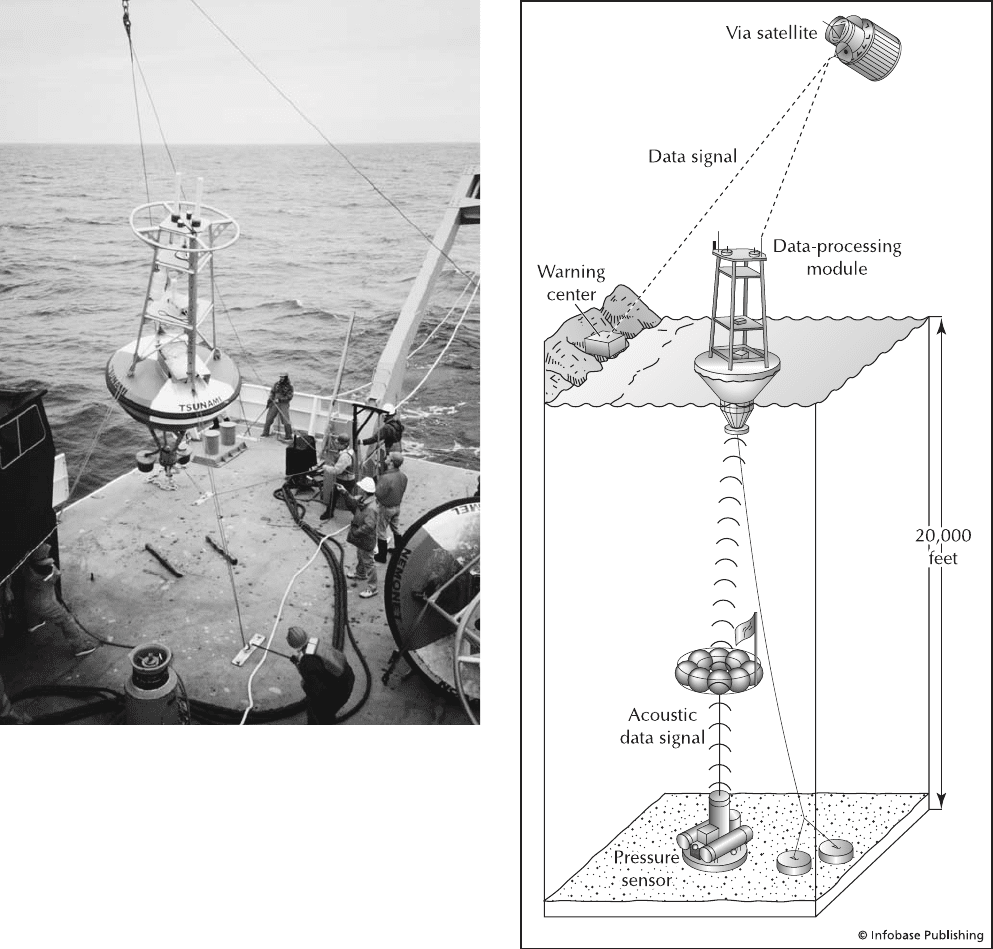
Deep Ocean Assessment and Reporting of Tsunamis
program (DART) DART is an international early warning
system for tsunamis that are still distant from coasts. The
equipment used in this system consists of seafloor seismic sen-
sors that record changes in the weight of water above them to
detect a tsunami passing over. Information is then sent to a
buoy on the surface of the water. The buoy sends the data to
the Geostationary Operational Environmental Satellite, which
can broadcast information to land-based receivers. Coupled
with the global seismic network, DART can prove effective
in warning coastal communities about impending tsunamis,
permitting full evacuations before their arrival.
deformation Deformation, or strain, is the change in shape
or state of a material in response to an applied stress. Defor-
mation may be brittle, where a material breaks and loses
cohesion, like broken glass; ductile, where a material bends
and stretches but does not lose cohesion, like clay or putty;
or elastic, where an object changes shape only when stress
is applied but then returns to its original shape when stress
is removed, like a rubber band. Brittle deformation generates
earthquakes, and the seismic waves cause elastic deforma-
66 decade volcanoes
tion of the materials through which they pass. Deformation
may also be homogeneous, where it affects an entire body of
material in the same way, or heterogeneous, where it is con-
centrated in a zone like a fault.
Delaware United States The small state of Delaware is
located in a region of minor seismic risk. Only a few nota-
ble earthquakes have occurred in Delaware. An earthquake
on October 9, 1871, reportedly caused damage to windows
and chimneys in Wilmington and was felt also in Oxford
and New Castle, as well as in Pennsylvania and New Jer-
sey. On March 25, 1879, an earthquake along the Delaware
River was felt over an area of about 600 square miles (1,554
km
2
), in Dover and below Philadelphia, Pennsylvania. The
affected area extended between Chester, Pennsylvania, and
Salem, New Jersey. The earthquake of May 8, 1906, near
Seaford, Delaware, shook buildings and was felt elsewhere
in Delaware and in Maryland. A significant earthquake
(over 4 on the Richter scale) took place in Wilmington in
1971.
Denali Fault Alaska A powerful earthquake of magni-
tude 7.9 occurred on the Denali Fault, Alaska, just after
noon on November 3, 2002. Because the area was so sparsely
populated, no one was killed, and there was little damage.
The Denali Fault is a major dextral strike-slip fault with
regular and intense seismic activity. There was a major fore-
shock of magnitude 6.7 10 days prior to the main shock.
When the quake occurred, it propagated eastward at 7,000
A tsunami receiver-transformer buoy being deployed from a research
vessel in the Pacific Ocean. (Courtesy of NOAA)
Diagram showing the components of DART. The ocean floor pressure
sensor sends information to the fixed position buoy that processes the
data and beams it to a satellite that in turn beams it to a warning center.
Although complex, this is a real-time monitoring system.
Denali Fault 67
miles per hour (11,200 km/hr) to produce a surface rup-
ture some 209 miles (335 km) long and with up to 29 feet
(8.7 m) of offset. Shaking lasted approximately 90 seconds,
producing a 16–24-mile (9.6–14.5-km)-wide band of exten-
sive landslides along the fault and fissures that could
have swallowed a bus. liquefaction caused sand boils
and other surface flow, and seiches were strong in Seattle,
Washington, but identified as far away as Louisiana. Yel-
lowstone experienced an intense earthquake swarm as a
result of the shock. Remarkably, the Trans-Alaska Oil Pipe-
line that crosses the Denali Fault, carrying 17% of the U.S.
domestic oil supply, did not break even after the earthquake
shifted the ground some 14 feet beneath the pipeline. If it had
broken, it would have resulted in a major environmental and
economic disaster for the United States. The pipeline was so
well engineered that there was not even a disruption in sup-
ply. This is earthquake prevention at its best.
Denizli earthquake, Turkey At 8:30 a.m. on February 25,
1702, a devastating earthquake shook southwestern Turkey.
The epicenter was at the kaza of Denizli, but the shock was
violent in Smyrne and felt strongly in Chios. The estimated
Richter magnitude was 7.0, and damage was estimated at
X on the modified Mercalli scale. The shock was so strong
that it diverted the course of the Gumus Cay (River) near
Eskihisar. There are reports of tent cities having been set up
because there were so many buildings destroyed. The death
toll for this event was 12,000 people in Denizli alone.
Denizli was reportedly struck by yet another strong
earthquake on November 19, 1717. It had an estimated mag-
nitude of 6.6 and an intensity of IX on the modified Mercalli
scale. It reportedly flattened 10 villages within a six-mile (10-
km) radius of Denizli and killed 6,000 people within Denizli
alone.
Deriba caldera, Sudan The Deriba caldera occupies the
summit of Jebel Marra Volcano in the western central portion
of the Sudan. Although the geologic history of the volcano is
uncertain, it has been suggested that olivine basalt built up
during early eruptions at the site and then was eroded away
after activity ceased. When eruptions resumed in a second
phase of activity, the lavas were more felsic. According to
this scenario, the third and most recent phase of activity has
involved the formation of many secondary cones. Deriba cal-
dera is thought to have originated during this third phase. A
central cone and a lake have formed in the caldera. Although
it is not known exactly when the caldera formed, it may have
originated in historical times. There have been no recorded
eruptions at the caldera, but hot springs and fumaroles
were reported in the crater in the mid-20th century.
Jebel Marra is located within the great Sahara. However,
its higher elevation causes it to get much more rain than the
surrounding area, a phenomenon called orographic precipita-
tion. Not only is there a lake in the caldera but streams flow
down the slopes but disappear into the desert.
Devils Tower Wyoming, United States Devils Tower is
a famous example of a volcanic neck. The volcano that
formed Devils Tower was active some 40 million years ago
and is an unusual composition called a phonolite. The neck
cooled relatively quickly and at a very shallow level. The
vertical columnar joints all around it, just as in volcanic
flows, are a result of this cooling history.
dextral fault Also referred to as a right lateral strike-slip
fault. It is a strike-slip fault where the block on the opposite
side of the fault from the observer moves to the right. There
is only lateral and no vertical movement on these faults.
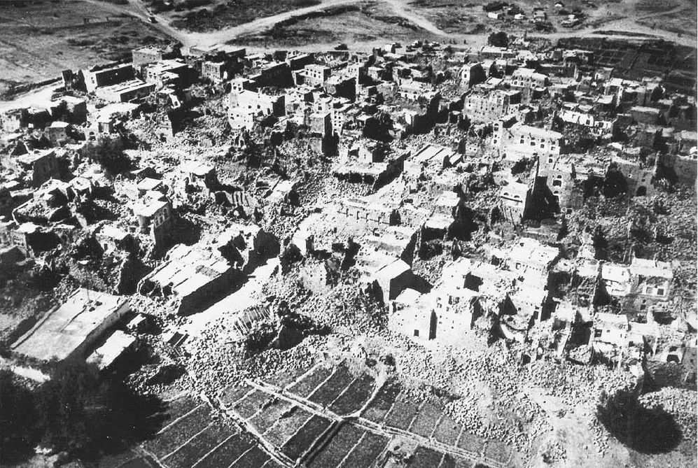
Dhamar earthquake, Yemen At 9:13 p.m. on December
13, 1982, a strong earthquake struck northern Yemen. The
epicenter was near the city of Dhamar, and the focus was
shallow, at about three miles (5 km) in depth. The Richter
magnitude of the earthquake was 6.0, and the damage was
VIII on the modified Mercalli scale. The death toll from
this event was 2,800 people as the result of intense shaking
of structures that were not designed to be earthquake-resis-
tant. In all, the earthquake destroyed over 300 villages and
left 700,000 people homeless. Total damage was estimated at
about $2 billion.
diabase The mafic plutonic rock, gabbro, but with a par-
ticular texture. In these rocks, pyroxene must occur in well-
formed crystals, whereas plagioclase fills the interstices.
They commonly occur in dike feeders to basalt volcanoes.
The famous landmark Devils Tower, in Wyoming, is a volcanic neck.
There used to be a conical volcano around it, but weathering has left
only the old conduit for lava. Because the cone was mostly ash and
pyroclastics, it was more susceptible to weathering. Columnar joints give
it the tree stump appearance. (Courtesy of the USGS)
68 Denizli
Diamante caldera, Chile The Diamante caldera is located
in south-central Chile and is thought to have been formed by
great eruptions of pyroclastic flow deposits that covered
several thousand square miles. The stratovolcano Maipo
occupies part of the western portion of the caldera. Several
eruptions were reported in the 19th and 20th centuries, but the
accuracy of these reports is questionable because the “erup-
tions” may have been nothing but enduring plumes of steam.
Its remote location makes information sparse and unreliable.
diamond Diamond is the hardest naturally occurring min-
eral and one of the most precious gemstones. Hardness means
that it can scratch any other substance but that it cannot
be scratched. Diamonds are made of pure carbon just like
the mineral graphite, but the atoms are packed more tightly
together under mantle pressures. Diamond is associated with
plutonic-volcanic formations, particularly the famous kim-
berlites, or “diamond pipes,” of South Africa. Diamonds are
believed to have been found first in Borneo and India. Brazil
was a major producer of diamonds in the 18th and 19th cen-
turies. Diamonds were discovered in South Africa in 1867 on
the shore of the Orange River near Hope Town, and several
years later, primary deposits of diamonds were found on the
plateau between the Modder and Vaal Rivers. These primary
deposits were located in volcanic pipes containing a variety of
peridotite (kimberlite). These pipes intersected the surface in
circular or elliptical areas. Some diamonds were recovered on
the surface from a weathered material called yellow ground,
but others had to be extracted from the harder “blue ground”
below. Important South African diamond mines include Bult-
fontein, De Beers, Du Toitspan, Kimberly, and Wesselton.
For a time most of the world’s annual output of natural dia-
monds came from the pipe mines, but, later, alluvial deposits
in Africa surpassed the pipe mines in production.
Diamond production is not confined to Africa; dia-
monds have been recovered in parts of the world as widely
separated as Mexico, Siberia, and Canada. Diamonds not
used as gemstones have widespread industrial uses. Indus-
trial-quality diamonds occur naturally in forms including
ballas (spherical aggregates of diamond crystals), bort (crys-
tals with irregular shape, bad flaws, and numerous inclu-
sions; used in drilling and abrasives), and carbonado (a dark
variety of diamond). Although a colorless diamond is pure
carbon (as demonstrated by the fact that burning such a dia-
mond in an oxygen atmosphere yields only carbon dioxide),
other elements may occur in diamonds and affect the color
of the stones; blue, green, and yellow gem-quality diamonds
have been found.
Damage to buildings as a result of the Dhamar, Yemen, earthquake in 1982 (Courtesy of the USGS)
diamond 69
Dieng Plateau Java, Indonesia The Dieng Plateau is an
area of frequent volcanic activity and is thought to occupy
an ancient caldera. The word Dieng means “Abode of the
Gods” and as such, there are many temples located there.
There have been at least 18 eruptions since 1375. Small
explosive and phreatic eruptions (VEI = 1–2) characterize
the area. An explosive eruption apparently occurred around
the year a.d. 1300. An eruption in 1786 was preceded by
several months of earthquakes and involved emissions of sul-
furous vapor. That eruption killed 38 people and destroyed
a village. An eruption in October 1826 was accompanied
by sounds like cannon fire. Several days later, explosions
occurred, and earthquakes were felt at a considerable dis-
tance. The source of this activity is uncertain. Except for a
minor eruption in 1847, the Dieng Plateau was quiet until
1884, when solfataras and fumaroles became more
active and mud eruptions occurred. Powerful earthquakes
shook the area in 1924 and 1928. Eruptive activity started
just after an especially damaging series of earthquakes in
May 1928. Some 40 people were killed during this eruption.
Gas emissions continued for the next nine years. In 1939,
earthquakes preceded minor phreatic eruptions that killed
10 people. lahars were produced during this eruption. Late
in 1944, several phreatic explosions occurred. One of these
killed a large number of people; one estimate puts the death
toll at more than 117 with 250 injuries. A small ashfall
took place in 1953, and a minor eruption occurred in 1954.
An eruption in 1964 killed some 114 people. More than
149 people were killed in a large outburst of carbon dioxide
and hydrogen sulfide gas in 1979. The people were asphyxi-
ated as they fled. Of those who managed to escape, 1,000
were injured, 100 of whom required hospitalization. More
than 15,000 people were evacuated during this event, and
many livestock were killed. A minor earthquake swarm
was noted in 1981, and another such swarm in 1984 caused
some damage to property. Another earthquake was felt
over a wide area around Dieng in 1986, but thermal activ-
ity appears to have been unaffected. A hydrothermal area
in the Dieng Plateau has been investigated for geothermal
energy.
dike A near vertical, tabular body of intrusive rock that
cuts across the local country rock strata at a high angle.
As opposed to forcing their way into country rock, dikes pas-
sively fill cracks that are tectonically produced. Dikes may
radiate outward in a starlike pattern from a central volca-
nic neck or column of rock left standing after erosion has
removed the outer layers of the volcano. They can also form
rings around volcanic centers. It just depends upon the stress
field in the area.
dilatancy Defined as the increase in volume resulting from
tiny (or any other size) cracks developing in a rock, dilatancy
has been an important concept in attempts to predict earth-
quakes. There has been disagreement about the process or
processes involved in the postulated relationship between
dilatancy and seismic activity. According to one hypoth-
esis, water moves into the area affected by the small cracks
just before an earthquake, weakening the rock; in another
hypothesis, most of the cracks close in the affected region just
before an earthquake occurs.
dilational wave See p-wave.
Dinar earthquake, Turkey On October 1, 1995, an earth-
quake of Richter magnitude 6 occurred. There were 101
deaths and thousands injured. Some 50,000 people were left
homeless as the result of the destruction of more than 4,500
houses and building.
diorite A pluton of intermediate igneous rock. It is the
plutonic equivalent of the volcanic rock andesite or andesite
to dacite. Common minerals include plagioclase, pyrox-
ene, and hornblende. These rocks are common in mag-
matic arcs, at least in the early stages. They form the lower
part of the huge batholiths found there. They are com-
monly succeeded by granodiorite and granite. Examples
of diorite plutons can be found in Sierra Nevada.
dip-slip fault A fault in which movement is in a dip sense.
This means that all movement is in a vertical rather than in a
lateral sense. Dip-slip faults include normal faults, reverse
faults, and a subset of reverse faults called thrust faults.
directivity Directivity is an effect of fault rupture where
the ground motion from the earthquake is more intense in the
direction of the rupture propagation than it is in any of the
other directions from the earthquake source.
discordant Refers to tabular plutons that are intruded
across the existing strata. dikes, for example, are discordant
by definition. In contrast, sills are concordant because they
are intruded along the layering. For plutons emplaced at shal-
low levels, like those that feed volcanoes, the distinction is
relatively plain. For plutons emplaced at deep levels, however,
the surrounding rocks are soft and flow with and around the
pluton. The distinction can be complex.
dispersion (of waves) Dispersion is the spreading out of
an earthquake wave train as a result of each wavelength in
the train traveling with a different velocity.
displacement Displacement is the change in position of a
reference point over time. In fault terms, it is the amount of
movement that takes place on an individual fault through a
single or multiple events. The displacement on a fault for a
single earthquake might be centimeters to meters, either sub-
surface (blind) or shown by the offset of a surface feature.
ductile faults may undergo semi-continuous movement so
do not have specific events but still experience displacement.
divergent boundary A boundary between lithospheric
plates in which the plates move away from each other. The
boundary can occur in one of two geometries, symmetric
(pure shear) where both sides appear the same and asymmet-
ric (simple shear model) where they do not. Divergent bound-
aries occur in two types, those on continental crust and
those on oceanic crust. On continental crust, they are rift
70 Dieng Plateau
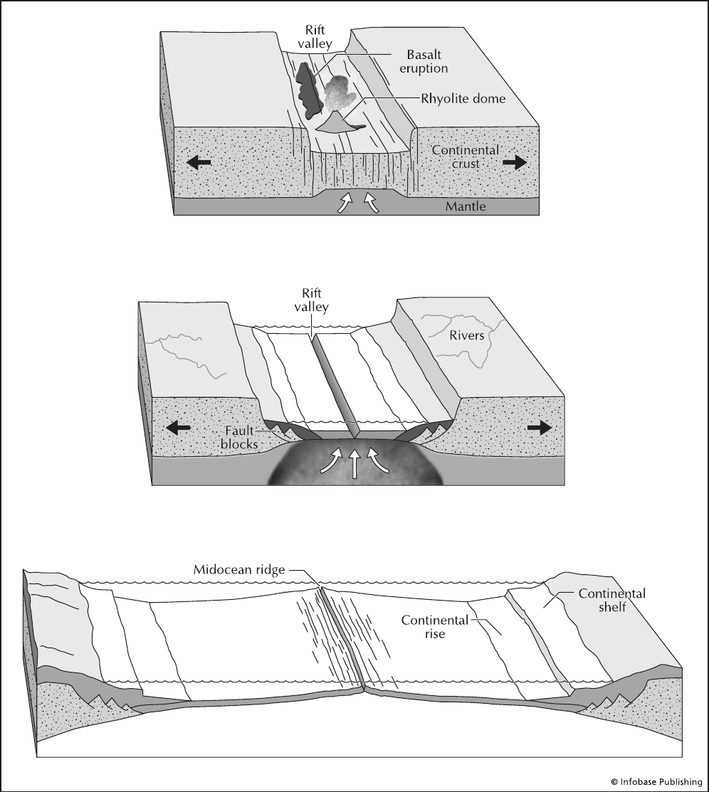
zones with four distinct stages. The stages begin with thermal
bulging and uplift continue with subsidence and basin devel-
opment. Finally, there is the development of oceanic crust and
a mid-ocean ridge. Therefore, one type develops into the
other with time. The early two stages include normal faulting
and extensive earthquake activity. Later, in the second stage,
The three stages in the development of a divergent margin. First (A), the crust can elevate, but soon normal faults and grabens, flood basalts, and rhyolite domes
form. The Basin and Range Province is in this stage. Next (B), a large depression or rift valley forms that eventually contains ocean crust and a narrow sea. The
Gulf of California and the Red Sea are similar to this phase. Finally (C), a full ocean basin and a mid-ocean ridge such as that in the Atlantic Ocean is formed.
divergent boundary 71
A
B
C