Gates A.E., Ritchie D. Encyclopedia of Earthquakes and Volcanoes
Подождите немного. Документ загружается.

gabbro A mafic rock that is characterized by coarse
grains. Gabbro is composed of plagioclase and pyroxene
and less commonly olivine and hornblende. Gabbro is the
plutonic equivalent of basalt. dikes and sills of gabbro are
common in areas of basalt volcanism. They make up a large
proportion of oceanic crust. There are also some large gab-
bro bodies on continental crust as well. The Palisades Sill
in New York–New Jersey is composed of diabase, which is a
textural variety of gabbro. stocks and batholiths (circular
plutons) of gabbro are rare but can yield significant quanti-
ties of platinum and chromium.
Gadamsa See Asawa.
Gademota See Asawa.
Galápagos Islands Ecuador The Galápagos Islands are
located off the west coast of South America and are the
summits of volcanoes along a hot spot. The islands are per-
haps best known for their giant tortoises and for remarkable
variations in the bodily forms of animal populations from
one island to another. The most active of the volcanoes in
the Galápagos Islands is Fernandina, a major eruption of
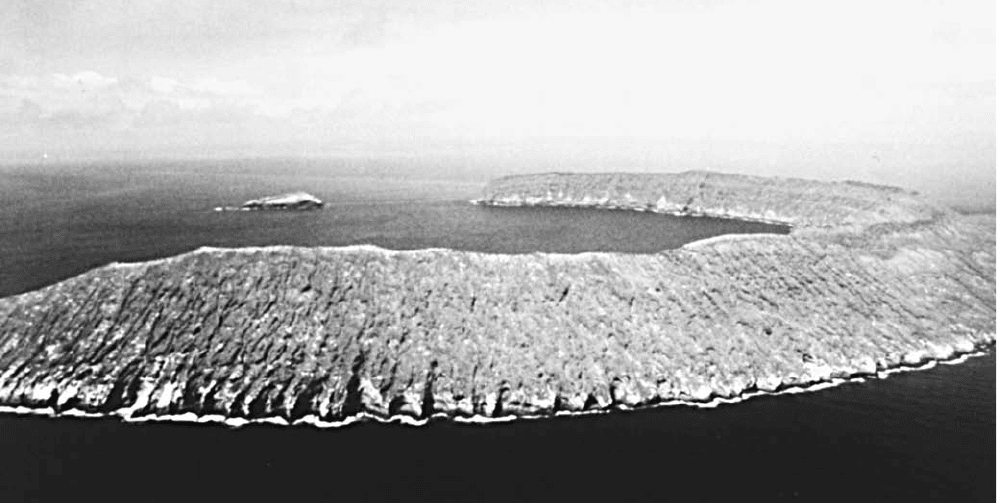
Flooded caldera rim forming an arcuate island in the Galápagos, Ecuador (Courtesy of NOAA)
G
93
which took place in 1968 and again in 1995. Other volca-
noes include Alcedo, Cerro Azul, Darwin, Ecuador, Sierra
Negra, and Wolf, all on Isabela Island.
Galung Gung volcano, Java Not quite 7,000 feet (2,134
m) high, Galung Gung is adjacent to the Plain of Ten Thou-
sand Hills, which actually number several thousand less. They
are thought to have been formed by a lahar that accompa-
nied one of Galung Gung’s eruptions. Galung Gung erupted
twice in 1822 (VEI = 5) and destroyed no fewer than 114
villages and killed more than 4,000 people. Since then it has
erupted four times, most recently in 1984. The 1982 eruption
(VEI = 4) killed about 68 people and caused $15 million in
property damage.
Gamalama volcano, Halmahera, Indonesia Also known
as Peak of Ternate, Gamalama stratovolcano forms a
seven-mile (11-kilometer)-wide island. It has had at least 70
eruptions since 1538. Eruptions from 1771 to 1775 caused
fatalities including a
NUÉE ARDENTE that killed more than
1,300 people in 1775. Other eruptions that resulted in fatali-
ties occurred in 1838, 1871, and 1962. The most recent erup-
tion was in 1993. Most of the eruptions are explosive with
VEIs of 2–3.
Gansu earthquake, China An earthquake estimated at
magnitude 8.6 on the Richter scale struck the Chinese
province of Gansu (formerly Kansu) on December 16, 1920,
killing approximately 180,000 people. An additional 20,000
deaths during the following months were attributed to lack of
shelter during bitter winter weather. Natural dams formed by
landslides had to be destroyed to prevent flooding.
Garibaldi, Mount British Columbia, Canada A volcanic
mountain at the northern end of the Cascade Range.
Gaua Island Vanuatu Located in the northern portion of
the Vanuatu archipelago, Gaua Island is a stratovolcano
with a caldera occupied by a lake, Steaming Hill Lake, and
by a postcaldera cone, Mount Gharat. From 1963 to 1982,
Mount Gharat underwent at least 13 eruptions. Most erup-
tions were small (VEI = 2) and lasted only one to two days.
The 1963 and 1973–74 eruptions lasted several months.
Geger Halang caldera, Java, Indonesia The Geger Halang
caldera is located in central Java near Juningan and Telaga
and has a history of eruptive activity dating back to the late
17th century. How the caldera originated is uncertain. Pos-
sibly the caldera collapsed, but landslide activity has also
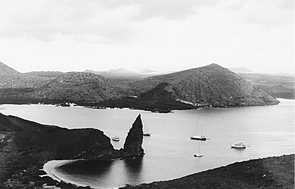
Small resurgent dome volcanoes within a larger caldera scatter across the landscape of the Galápagos Islands, Ecuador, in the Pacific Ocean. (Courtesy
of NOAA)
94 Galung Gung
been put forward to account for the calderas formation.
Before the collapse, a stratovolcano is thought to have
occupied the site of the caldera. The stratovolcano Cereme
is situated on the caldera’s northern rim. It has erupted six
times between 1698 and 1951. An explosive eruption in
1698 reportedly caused many deaths. Other eruptions are
recorded in 1772, 1775, and 1805. Earthquakes and sub-
sidence in 1876 at a site several kilometers away from the
caldera may have been unrelated to volcanism at Geger
Halang. Emissions of sulfur gas increased in 1917 as did
fumarolic activity in 1924. A series of eruptions in 1937
and 1938 was accompanied by a large number of strong
earthquakes. An eruption in 1951 consisted of a single det-
onation followed by an emission of thick smoke. tectonic
earthquakes occurred in 1973 but evidently were unrelated
to volcanism at the caldera.
Gemini Seamount volcano, eastern New Hebrides A
submarine volcano that has been erupting regularly since
1996. It was reported to have produced explosions every
three to nine minutes. These eruptions produce steam and
ash.
geodesy Geodesy is the science of determining the size and
shape of the Earth, both on the large and local scale, and the
precise locating of points on the surface. Geodedic surveys are
conducted at all scales on a regular basis, now with the aid of
satellite telemetry. These surveys can help to identify areas that
are bulging or subsiding, which may be precursors to earth-
quakes and volcanic eruptions. They can also determine uplift
and subsidence as the result of seismic and volcanic events.
geology Literally translated, geology means “science of the
Earth,” but it is more than that. It is a composite science that
encompasses all other sciences—biology, physics, and chem-
istry as well as many aspects of engineering—and even has
subdisciplines of each with composite names (geochemistry,
geophysics, etc.). It is the study of the chemical and engi-
neering properties of the materials of the Earth—rocks, min-
erals, soils, fluids (water, oil, etc.), and gases. It is the study
of the internal and external processes that affect the planet,
including plate tectonics, deformation, surface process
(geomorphology), magma generation and movement, and
even environmental processes. It is also the study of the his-
tory of the planet, the internal and external changes that have
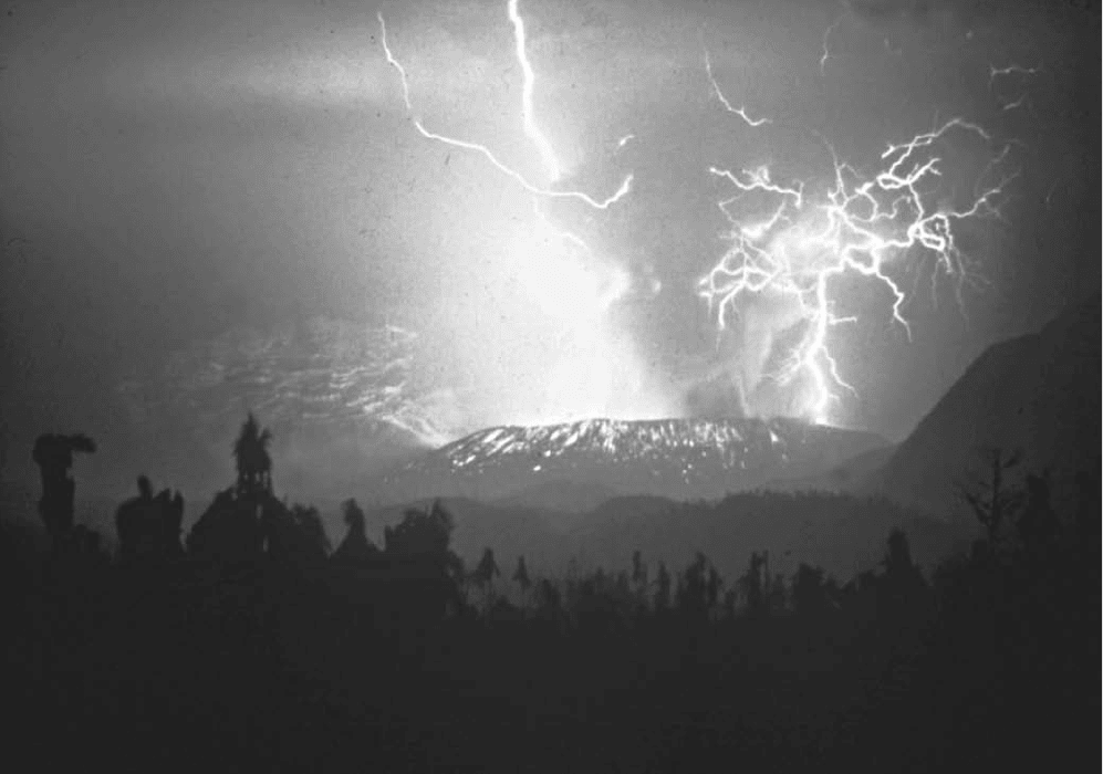
Static electricity generated during an eruption produces lightning. (Courtesy of the USGS)
geology 95
taken place through time, and the history of life through fos-
sils (paleontology). In the 19th century, geology was by far
the most influential of the sciences, and most scientists were
geologists. In the 20th (and 21st) century, humans relied
on the expertise of geologists to provide virtually all energy
needs. It is geologists who find all of the oil, natural gas, and
nuclear energy. Now geologists have added environmental
analysis and cleanup to their repertoire. Considering that
when a particle, gas, or fluid settles to the ground or pene-
trates the surface, it becomes the realm of the geologist, virtu-
ally all of the Earth is covered by this science.
geomorphology The study of surface landforms and their
evolution. These forms are grouped by the type of environ-
ment in which they occur. Deserts form dunes and ripples,
mesas and buttes, and related features. Beaches form dunes,
spits, and strands of sand. Glacial environments include
outwash plains, gravel piles and other features. Rivers have
gravel bars and sand. The landforms and surface deposits are
in the realm of geomorphology.
geophysical monitoring Monitoring of volcanoes using
geophysical techniques to predict eruptions. Swarms of
microearthquakes or small earthquakes record the move-
ment of magma upward in the magma chambers prior to
eruption. By monitoring seismic activity, geologists can pre-
dict eruptions and recommend evacuation.
geophysicist Scientist who studies the physical properties
of Earth. It is the geophysicist who monitors seismic activ-
ity on faults. They determine the source and magnitude of
earthquakes as well as the resulting damage. Their work is
used to construct seismic risk maps. Eventually, their studies
may lead to reliable earthquake prediction. Geophysicists also
do the geophysical and topographic monitoring of volcanoes
to help predict eruptions.
geophysics Science of the physical properties of Earth
including seismology, the study of earthquakes.
Georgia United States Although the state of Georgia is not
itself highly susceptible to earthquakes, it has been affected
strongly on occasion by powerful earthquakes in neighbor-
ing states, such as the New Madrid earthquake and the
Charleston, South Carolina, earthquake. An earthquake
in northern Georgia on November 1, 1875, affected an area
of about 150 by 200 miles (241 by 322 km). Portions of the
state, especially along its coast, are vulnerable to damage
from lique-faction in the event of future strong earthquakes.
geothermal energy Geothermal energy may be defined
as energy that is naturally given off by Earth. Sources of
enhanced geothermal energy may include geysers, hot
springs, and volcanoes. Although facilities for exploiting
geothermal energy have been built at numerous locations in
several countries. The potential for utilizing this source of
energy appears to be unlimited. Considering that at just a few
feet underground, the temperature remains a constant 55°F.
There is great potential for supplemental cooling in the sum-
mer and heating in the winter. Obviously, other systems must
be utilized as well, but it is much easier to warm a house from
55°F than from 25°F. On the other hand, in some areas, the
geothermal energy can provide all or nearly all of the energy
needs of a community. In these areas, heat from within Earth
is concentrated in formations at or near the surface where the
heat is stored and can be tapped conveniently.
The geology of geothermal energy resources is complex,
but commercially exploitable geothermal resources tend to be
concentrated along certain areas. Of particular interest are
areas of crustal spreading, where new crust solidifies from
molten rock rising to the surface, and along plate boundar-
ies, where converging plates give rise to conditions favoring
increased heat flow to the surface. In either case, magma
rising from below brings large amounts of heat toward the
surface. Heat from the magma converts underground water,
whether natural or introduced, into geothermal systems,
which may be dominated either by liquid or by vapor. The
former tend to be high-pressured, whereas the latter are com-
paratively low-pressured. Geothermal systems have been used
for centuries on a small scale for heating, but application of
geothermal energy to other uses began only in the late 18th
and early 19th centuries, starting in Italy.
Development of geothermal energy resources in New
Zealand began shortly after World War II, and the first
such facility there was finished in 1958, at the Wairakei
fields. Wairakei derives its energy from a huge volume of hot
rock believed to be supplied with water by rainwater seep-
ing down from the surface. Development is thought to have
touched only part of New Zealand’s geothermal energy
resources. Geothermal heating facilities are widespread in
Iceland, which lies along the Mid-Atlantic Ridge and
is the site of intense and frequent volcanic activity. In this
arrangement, hot water from underground is distributed from
central locations to users and achieves good results with less
pollution that other heating systems based on combustion
of fossil fuels. Geothermal heating in Iceland also is used in
greenhouses and in various industrial processes, such as dry-
ing seaweed and washing wool. The preeminent geothermal
power facility in the United States is located at the geysers
in northern California near San Francisco and is oper-
ated by Pacific Gas and Electric Company. Other sources of
geothermal energy exist at numerous locations in the United
States, and some are used for heating, but other factors, such
as distance from major population centers, restrict the avail-
ability of these heat sources for generation of power or other
large-scale commercial applications. Japan and Mexico also
have, or have plans to develop, geothermal power facilities.
Generating electricity using geothermal energy causes
various problems such as mineral-rich water corroding metals
and building up on turbines. In some locations, earthquakes
are associated with high heat flow from Earth’s interior.
Sometimes the earthquakes are only minor, but some may be
much more powerful. Earthquakes in geothermal areas are
thought to be connected to motion on faults along which
geothermal fluids flow. Volcanic activity also is associated
with areas suitable for geothermal power production because
volcanoes themselves constitute areas of high heat flow.
See also Lardarello; plate tectonics.
96 geomorphology
geyser A jet of water that erupts on an occasional basis
from a small opening in Earth’s surface. (The hole itself also
may be called a geyser.) In a typical geyser, an underground
heat source (typically a magma body) sits beneath rock strata
with large interconnected void spaces—in other words, some-
thing like a cave system. Groundwater seeps into these voids
until they are full of water. The water is quickly heated above
the boiling point, but it cannot boil because the pressure from
all of the water prevents it. High pressure can prevent liquids
from boiling. The water heats up until even the water near
the surface begins to boil. When it starts to turn to steam, the
pressure is released, and the water in the voids flash boils all
at once. The quick conversion from water to steam causes an
explosion. It creates a fountain of very hot water and steam
that may reach height of several hundred feet that empties the
void space of water. The cycle of vapor generation and erup-
tion then starts over as groundwater begins to seep back into
the void space. Among the most famous geysers is Old Faith-
ful at Yellowstone National Park in Wyoming, United
States. Some geysers derive the vapor for their operation from
a different source-release of dissolved carbon dioxide.
Gharat, Mount See Gaua Island.
Gilan earthquake, Iran A massive earthquake struck
northwest Iran in the area along the Caspian Sea on June 21,
1990, at 12:30 a.m. It was one of the worst disasters in the
modern history of the region. The main shock registered a
7.7 on the Richter scale but strong aftershocks with mag-
nitudes up to 6.5 continued to rock the area for the follow-
ing four days and continued to cause loss of life into July.
The main shock was felt throughout northwestern Iran and
even in Azerbaijan, USSR. The source of stress for this event
was the continuing collision of the Arabian plate with Eur-
asia, which forms the Zagros orogeny. The focus of the
earthquake was 11.5 miles (19 km) in depth.
The casualties from this event were enormous. Upward
of 50,000 people lost their lives, and 200,000 people were
injured. Over one-half million people were left homeless, and
the total damage was $8 billion. surface waves shook loose
avalanches and rockfalls from the mountains. Large
landslides struck the Rascht-Qazvin-Zanjan area, causing
great destruction and rupturing a dam that caused flood-
ing and casualties in the valley below. More than 100 towns
were destroyed or heavily damaged in this event. Bad weather
immediately following the event hampered rescue operations,
undoubtedly increasing the death toll.
glaciation The formation of glaciers, great fields of ice
resulting from the accumulation and compression of snowfall
over long periods, has helped shape the peaks of numerous
volcanoes. A case in point is Oregon’s Mount Hood, where
glaciers have carved valleys in the flanks of what apparently
once was a conical mountain. The water contained in glacial
ice can melt and generate destructive lahars during erup-
tions. mudflows pose a particular threat to settled areas
near the volcanoes of the Cascade Mountains in the Pacific
Northwest of the United States. avalanches also may
occur when eruptive activity melts glacial ice on a volcanoes
summit and weakens the structure of the ice sheets. At three
locations in the United States, Mount Wrangell in Alaska
and Mount Baker and Mount Rainier in Washington,
heat and steam from the volcanoes have created a network
of caves and passageways in the glacial ice at the summits of
the volcanoes. Volcanoes under continental ice sheets can cre-
ate huge volumes of meltwater that can cause major floods.
In Iceland, the volcano Grimsvötn has accumulated up
to three cubic kilometers of meltwater. When the water was
released in an ice-dam break (jökulhlaup), floods devastated
the country. Floodwaters from a glacial lake in what is now
western Montana are thought to have played an important
part in shaping the landscape of the Columbia Plateau in
Washington State, stripping away soil and scouring the land
down to bedrock. In some places, the floodwaters apparently
removed whole layers of basalt and thus produced clearly
visible mesas and terraces along the Columbia River.
global positioning system (GPS) GPS uses satellites
to find exact locations and elevations on the surface of the
Earth. The device locates satellite signals and triangulates its
position when it has located enough of them. The position is
commonly read in terms of latitude and longitude, but some
units also have the capability to plot the location on a map
and store each position as a way station. Previously, satellite
signals were scrambled for security reasons, and a location
was only accurate to about 165 feet (50 m). The scrambling
was discontinued several years ago, and GPS data are now
much more accurate. There is a difference between research-
grade GPS and those mounted in cars or sold in sporting
goods stores. The highly accurate GPS units determine loca-
tions to within one centimeter and are the type that are used
for earthquake and volcano studies.
gold One of the most economically valuable minerals, gold
is highly ductile and malleable, a good conductor of elec-
tricity, and resistant even to powerful solvents. Gold is found
in native (or pure) form as ores in areas of volcanic activity,
where chemical fractionation and hydrothermal activity
combine to concentrate the metal. Gold often occurs as min-
erals called tellurides and also may be found in native form in
veins of quartz. Deposits of gold along the Andes Moun-
tains played an important part in the conquest and coloni-
zation of South America’s Inca civilization by the Spanish
empire in the early 16th century. Drawn to the Andes by
reports of abundant gold, Spanish troops under the leader-
ship of Francisco Pizarro conquered the Inca by simply taking
their emperor Atahuallpa prisoner. The Spaniards demanded
a heavy ransom in gold for their imperial captive and, when
the ransom was delivered, had Atahuallpa killed. The Inca
gold reportedly was mined largely from placer deposits,
which occur when bits of gold are eroded away from their
original location (the mother lode) and laid down in sedi-
ments from which they may be extracted more easily than
from solid rock.
See also plate tectonics.
Good Friday earthquake Alaska, United States One
of the most powerful (M = 9.2) and destructive earth-
Good Friday earthquake 97
quakes of the 20th century, the Good Friday earthquake
struck the south coast of Alaska along Prince William
Sound on March 27, 1964, and lasted between three and
five minutes. The earthquake killed more than 100 people
and involved displacements of as much as 50 feet (15 m)
along various faults. Estimates of property damage from
the earthquake range in the hundreds of millions of dol-
lars. The Good Friday earthquake was notable for the
tsunami that accompanied it. The wave destroyed the
waterfront at Seward and, at Kodiak, wiped out much of
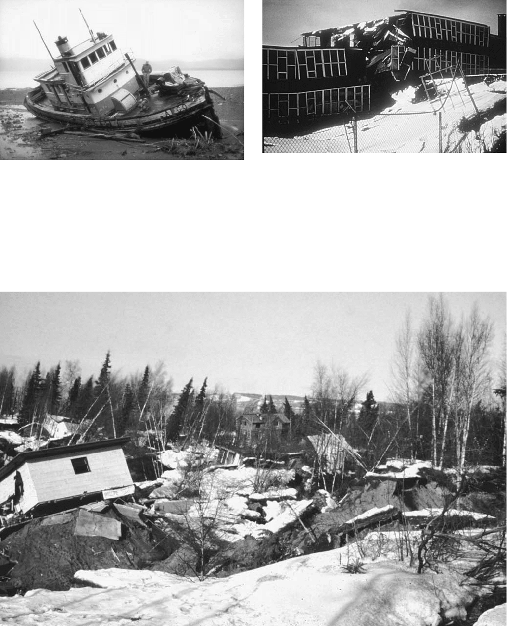
A boat washed far inland and beached by the surge of the tsunami
generated by the Good Friday earthquake, Alaska, 1964 (Courtesy of NOAA)
A large slump broke an elementary school in half during the Good Friday
earthquake in Alaska, March 27, 1964. The earthquake had a magnitude of
9.2 and caused over $538 million in property damage. (Courtesy of NOAA)
Chaotic jumble of houses, trees, and landscape resulting from slumping and surface failure during the 1964 Good Friday earthquake in Alaska (Courtesy
of the USGS)
98 Good Friday earthquake
the downtown area and destroyed almost half of the local
fishing fleet.
The tsunami caused extensive damage as far south as
Crescent City, California. More than 2,000 landslides
and avalanches were attributed to this earthquake, and at
one location at Shattered Peak in the Chugach Mountains,
an avalanche was found to have traveled several miles atop
a cushion of air across a glacier. Later examination showed
that the air cushion had preserved structures on the glaciers
surface as the avalanche passed. The earthquake had dra-
matic effects on lakes in Alaska; movement of lake waters
cast chunks of ice onto the shore and reportedly caused dam-
age to trees as high as 30 feet (9 m). Saltwater invaded certain
freshwater lakes along the shore. The Good Friday earth-
quake coincided with unusual observations in other portions
of the United States; the water level at one well in South
Dakota, for example, is said to have fluctuated more than
20 feet (6 m). Similar, though less dramatic, fluctuations were
reported from Puerto Rico and Australia at the time of
the Good Friday earthquake.
Gorely Khrebet caldera, Kamchatka, Russia The col-
lapse that created the Gorely Khrebet caldera is thought
to have had a volume of perhaps five cubic miles (21 km
3
).
The caldera is located on the edge of a large, negative-grav-
ity anomaly that is evidence of the existence of a huge, bur-
ied caldera. The Gorely Khrebet volcano occupies the center
of the caldera. Eruptions have been recorded in 1828, 1832,
1855, 1869 (uncertain), and 1929–31. solfataric activity
was reported in 1947. Temperatures of fumaroles increased
in 1960–61, and small eruptions of ash followed. Fumarolic
activity diminished for several years and then increased again
in the late 1970s as new fumaroles appeared and tempera-
tures in fumaroles rose. Gas plumes rose to heights of several
hundred meters in 1979. In June 1980, phreatic eruptions
began, and others took place over the following months.
Another eruption, similar to that of 1980–81, occurred in
1984–85.
graben A valley formed by the down-dropping of a fault
block along normal faults. A half-graben means only one
normal fault, but a full graben requires two normal faults
that slant toward each other. Grabens typically form in asso-
ciation with divergent boundary. There are many good
examples of grabens worldwide. Every basin in the Basin
and Range Province is a graben. The Newark Basin in New
Jersey, like the Hartford Basin in Connecticut and Mas-
sachusetts, and Gettysburg Basin in Pennsylvania are all
examples of half-grabens. The Rhine River valley and Viking
graben in the North Sea are famous examples of grabens.
During the 1964 Good Friday earthquake in Alaska,
grabens formed and caused extensive damage to property. In
one incident, a building toppled off the edge of a horst, or
elevated block, and landed upside-down inside a graben.
Grand Banks earthquake, Newfoundland, Canada This
very powerful earthquake occurred on November 18, 1929,
and was centered under the Grand Banks of Newfoundland,
a rich fishing area off the east coast of Canada, east of Nova
Scotia. The earthquake measured 7.2 on the Richter scale.
Felt all throughout the New England region of the United
States and parts of Canada south of the Saint Lawrence
River and the Strait of Belle Isle, the earthquake stopped
clocks and shook objects from shelves on land and subjected
ships at sea to a powerful shaking. Because the epicenter was
some 250 miles (402 km) from the nearest land, very little
damage was done to inhabited areas. A tsunami associated
with this earthquake struck three hours later and reportedly
was responsible for extensive damage and the loss of 27 lives
at Placentia Bay, Newfoundland. Minor waves were reported
as far south as the shores of South Carolina. The earth-
quake broke submarine telegraph cables that were laid across
the area of the earthquakes epicenter in 28 places. The breaks
were caused by sediments that were shaken loose and that slid
down the continental slope like an undersea landslide but
called a turbidity current. By timing the point at which
each of the lines went dead and plotting their position under
water, it was determined that these turbidity flows achieved
speeds of up to 50 knots. For scientific purposes, this earth-
quake provided an excellent laboratory experiment.
Grand Coulee canyon, Washington, United States A deep
canyon cut into lavas by ancient floodwaters, Grand Coulee
is about 25 miles (40 km) long and 800 feet (244 m) deep
in places. The Grand Coulee lies approximately northeast
to southwest between the Columbia River and the Quincy
Basin and is the site of the Grand Coulee Dam. The waters
that carved the Grand Coulee in the lavas are thought to have
originated from the melting of a glacier immediately to the
north.
See also coulee.
granite A crystalline intrusive igneous rock, granite is one of
the most common plutonic rocks. It is commonly used as a
building material because of its availability and resistance to
weathering and wear. Granite displays an interlocking pattern
of crystals of such minerals as quartz, potassium (K-)feldspar
(see k-feldspar), some plagioclase, and possible biotite,
hornblende, and/or muscovite. Granite comprises an entire
family of rocks. Coarse-grained granite cooled slowly from the
molten to the solid state and thus gave large crystals time to
form. Fine-grained granite, on the other hand, cooled more
quickly so that crystals in the rock had less opportunity to
grow. Granitic rocks often are found in large circular to ellipti-
cal plutons called batholiths.
See also intrusion.
granitization Conversion of metamorphic rocks to gran-
ite by excessive heat and pressure and aided by water mov-
ing upward from deep inside Earth. Granitization is believed
to be responsible for forming plutons that show no clear
boundary with surrounding country rock.
granodiorite The plutonic equivalent of dacite-andesite
(intermediate composition). These rocks commonly form
large batholiths in the roots of magmatic arcs. The Sierra
Nevada batholith is largely composed of granodiorite, as are
undoubtedly the roots of the Andes Mountains.
granodiorite 99
gravity Gravity is one of the fundamental properties of
physics and the main contributor to the disaster in earth-
quakes and volcanoes. Gravity is the ultimate cause of all
mass wasting, including landslides and avalanches. It
is the reason that lava, lahars, and
NUÉE ARDENTEs come
down the slopes of volcanoes and wreak havoc. When sea-
floor faulting takes place, gravity is behind the ocean water
readjusting and thus producing a tsunami. It is also the rea-
son that buildings fall when damaged.
geophysicists study detailed variations in gravity to
determine subsurface features and processes. It is especially
useful for locating faults and plutons and in plate tec-
tonic applications. Microgravity studies can even be used to
track movements of magma.
Great Basin United States The Great Basin is an area in
California, Nevada, and western Utah where streams find
no outlet but drain instead into lower portions of the basin
itself. Death Valley occupies part of the Great Basin. It is
part of the Basin and Range Province.
Great Rift United States An area of parallel fractures in
present-day Idaho from which lava flows emerged and
covered an area of some 600 square miles (1,554 km
2
). The
most recent volcanic activity along the Great Rift is believed
to have occurred approximately 2,000 years ago.
Great Rift Valley Africa A region of East Africa charac-
terized by rifting and associated volcanic activity. The Great
Rift Valley is the inactive arm of the triple junction that
includes the Red Sea and the Gulf of Aden as the active arms
with fully developed mid-ocean ridges. The Great Rift Val-
ley crosses the countries of Eritrea, Ethiopia, Kenya, Uganda,
Tanzania, Rwanda, Burundi, Malawi, and Zambia. Some of
the worlds most famous volcanoes and calderas are located
along the Great Rift Valley. Most of the volcanoes are basal-
tic, but rhyolitic volcanoes are also present. The active rift-
ing also produces earthquakes on a regular basis.
See also Asawa; Fantale.
Greece With the exception of Italy, Greece is the most
active country in Europe in terms of earthquakes and volca-
noes and one of the more active in the world. Greece owes
its activity to its plate tectonic position in the eastern
Mediterranean basin. The Hellenic Arc marks a subduc-
tion zone where African oceanic crust is being consumed
beneath Eurasian crust along a small island arc. Turkey
is moving westward into Greece primarily along the North
Anatolian Fault through the processes of extrusion tecton-
ics. The western margin of Greece along the Aegean Sea is
being affected by the compressional activity that affects Italy.
Basically, Greece is being squeezed from all sides.
There are several dormant and inactive volcanoes along
the Hellenic Arc. The only large eruption was from Thira
(Santorini) in 1,500 b.c., which may have been one of the
greatest in historical times. Earthquakes, on the other hand,
occur in Greece frequently. Deep focus earthquakes are
exclusively associated with the Hellenic Arc and and define a
Benioff zone beneath the Mediterranean Sea. Shallow focus
earthquakes occur all over. The recurrence interval stud-
ies for Greece show that there is on average, one magnitude
6.3 earthquake per year. Earthquakes with magnitudes of 8.0
or greater have a recurrence interval of only 49 years. Earth-
quakes in Sparta, Corinth, Chios, and Helike are examples
of truly devastating events. Because Greece is surrounded by
water, there is also great potential for tsunamis. Waves with
runup heights of over 100 feet (30 m) have been recorded
in the 20th century. The Gulf of Corinth is especially suscep-
tible. It is a great credit to the ingenuity of the Greeks that
these powerful events have not caused greater devastation in
terms of loss of life and property.
Grimsvötn volcano, Iceland Grimsvötn has erupted 45
times since records were kept. The 1934 eruption of Grims-
vötn, located underneath the Vatnajökull glacier, is a good
example of a jökulhlaup, or subglacial volcanic eruption. In
late March, an unseasonable increase in the volume of flow
in the Skeidara River, which carried away meltwater from
the glacier, was among the initial signs of the eruption. The
river was muddy and smelled of sulfur—further evidence
of an eruption. The flow of water from beneath the glacier
increased during the next several days, and portions of the
glacier broke away and were carried off with the water. So
great was the flow that is spurted under high pressure from
openings in the glacier. The eruption is believed to have cre-
ated a reservoir of meltwater under the glacier. As this pool
of water drained away, the glacial ice overlying the volcano
subsided until, soon after the jökulhlaup ended, eruptive
activity broke through the ice, and the volcano expelled gas
and ash into the air, depositing a light ashfall over several
thousand square miles. Every time Grimsvötn erupts, flooding
from these meltwaters occurs. In the 1996 eruption, a glacial
outburst released an enormous amount of dammed-up melt-
water at a rate of 1.5 million cubic feet (45,000 m
3
) of water
per second. Damage from this massive flood was estimated
at $12 million. The most recent eruption began in December
1998.
ground failure Any failure of the surface of the Earth
as the result of shaking from the passing of seismic waves
(primarily surface waves). Ground failure includes land-
slides, liquefaction, slumping, fissures, lateral spread-
ing, and any other resultant mass wasting. It typically does
not include rockfalls and rockslides or any other steep
slope process. Ground failure is commonly responsible for
the majority of the damage to human-made structures such as
buildings, bridges and roads.
ground motion In general terms, any shaking of Earth’s
surface resulting from a seismic disturbance. Most ground
motion that is felt is caused by surface waves (Love waves
and Rayleigh waves). However, body waves may also
cause ground motion to a lesser degree.
groundwater In general, any water moving beneath Earth’s
surface. Groundwater plays an important role in liquefac-
tion, the process responsible for much of the damage caused
by earthquakes in localities where structures are built on
100 Great Basin
unconsolidated soil with groundwater close to the surface.
Groundwater is derived largely from rainwater that has per-
colated downward through the soil and is confined to within
about 3,000 feet (914 m) of Earth’s surface. Groundwater
may travel through porous underground layers or conduits
called aquifers and emerge at the surface in the form of nat-
ural springs. Groundwater also provides the fuel for steam
explosions in geysers and in fumaroles.
Guagua Pichincha volcano, Ecuador This volcano, near
the capital city of Quito, is therefore the most dangerous
volcano in Ecuador. Guagua has had 25 historical eruptions
several of which devastated Quito. In 1660, more than 10
inches (25 cm) of ash and volcanic fragments blanketed the
city. The last eruption was in 1993. It killed a volcanolo-
gist who was studying the volcano at the time.
Guatemala Guatemala’s location in Central America
places it in one of the regions most susceptible to earthquakes
and volcanic eruptions. Notable earthquakes in Guatemala’s
history include that of the night of April 8, 1902. This earth-
quake lasted perhaps 30 to 40 seconds and caused some 2,000
deaths in Quetzaltenango. The earthquake coincided with a tor-
rential rainstorm, and the city lost electrical power and lighting.
The resulting darkness reportedly led to numerous deaths when
townspeople, fleeing buildings and running into the street, were
unable to see where they were going and perished when walls
fell on them. The heavy rainfall also resulted in deaths from
drowning. Shocks and rainfall continued for three days, making
relief work difficult or impossible. This earthquake occurred at
approximately the same time as the great eruptions of Mount
Pelée and Soufrière in the Caribbean.
The other major earthquake was on the Motagua
Fault in 1976. It had a magnitude of 7.5 on the Richter
scale and killed more than 23,000 people. It was felt over
38,610 square miles (100,000 km
2
) and caused $1.1 billion
in property damage.
Guatemala has several volcanoes including Acatenango,
Agua, Atitlán, Fuego, Pacaya, Santa María and Santia-
guito, and Toliman. Most of the volcanoes are inactive or
infrequently active. However, Fuego has erupted more than
60 times since 1524, making it the most active volcano in
Central America. The 1974 eruption was the most volumi-
nous in recent history. It has shown activity as recently as
1999. Pacaya is also active, having erupted 23 times since
1565. It has been erupting nearly continuously since 1965.
Santa María produced the second largest eruption of the 20th
century in 1902. It produced 1.3 cubic miles (5.5. km
3
) of
dacitic ejecta and had a VEI of 6.
Gunung Baru See Segara Anak.
Gunung Rinjani See Segara Anak.
Gutenberg, Beno (1889–1960) U.S. seismologist Guten-
berg, who relocated from Germany to the United States in the
years just before World War II, was a colleague of Charles
Richter and used earthquake data to estimate the diameter
of Earth’s core. The boundary between the core and mantle
is called the Gutenberg discontinuity.
Gutenberg discontinuity The zone that is marked by a
radical shift in the velocity of seismic waves deep within the
Earth that coincides with the boundary between the mantle
and core. Thus discontinuity was named after the famous
seismologist Beno Gutenberg.
guyot An undersea, flat-topped volcanic mountain that
does not extend to the ocean surface. Geologists believe that
guyots once reached the surface and formed islands but wave
action reduced them to subsurface levels. Guyots are often
found in chains with older, lower mountains at one end and
younger, taller guyots at the other. Guyots can have circular
reefs on their tops outlining the edges of the island.
guyot 101