Raven P.H., Johnson G.B., Mason K.A. Biology (Ninth Edition)
Подождите немного. Документ загружается.

Apago PDF Enhancer
North
Pole
Westerlies
Westerlies
60°S
30°S
30°N
60°N
0°
Northeast trades
Southeast trades
Equatorial
low precipitation
high precipitation
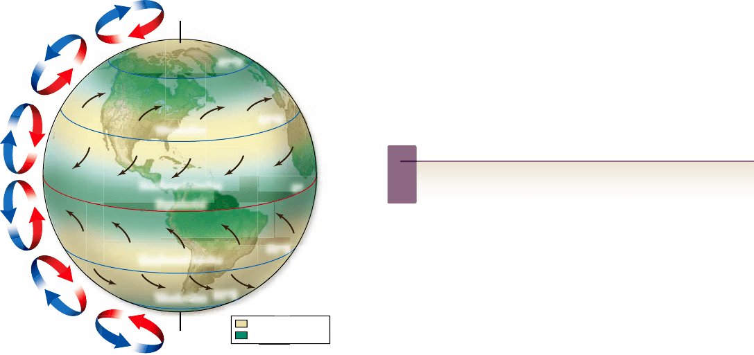
Figure 59.3
Global patterns of atmospheric circulation.
The diagram shows the patterns of air circulation that prevail on
average over weeks and months of time (on any one day the patterns
might be dramatically different from these average patterns). Rising
air that is cooled creates bands of relatively high precipitation near
the equator and at latitudes near 60°N and 60°S. Air that has lost
most of its moisture at high altitudes tends to descend to the surface
of the Earth at latitudes near 30°N and 30°S, creating bands of
relatively low precipitation. The red arrows show the winds blowing
at the surface of the Earth; the blue arrows show the direction the
winds blow at high altitude. The winds travel in curved paths
relative to the Earth’s surface because the Earth is rotating on its
axis under them (the Coriolis effect). A terminological problem to
recognize is that the formal names given to winds refer to the
directions from which they come, rather than the directions toward
which they go; thus, the winds between 30° and 60° are called
Westerlies because they come out of the west. Unfortunately,
oceanographers use the opposite approach, naming water currents
for the directions in which they go.
are affected by the spinning of the Earth on its axis; we discuss
this effect shortly.
For complex reasons, the air circulating up from the equa-
tor and away at high altitudes in both hemispheres tends to cir-
culate back down to the surface of the Earth at about 30° of
latitude, both north and south (see figure 59.3). During the
course of this movement, the moisture content of the air changes
radically because of the changes in temperature the air under-
goes. Cooling dramatically decreases air’s ability to hold water
vapor. Consequently, much of the water vapor in the air rising
from the equator condenses to form clouds and rain as the air
moves upward. This rain falls in the latitudes near the equator,
latitudes that experience the greatest precipitation on Earth.
By the time the air starts to descend back to the Earth’s
surface at latitudes near 30°, it is cold and thus has lost most of
its water vapor. Although the air rewarms as it descends, it does
not gain much water vapor on the way down. Many of the
greatest deserts occur at latitudes near 30° because of the steady
descent of dry air to the surface at those latitudes. The Sahara
Desert is the most dramatic example.
The air that descends at latitudes near 30° flows only
partly toward the equator after reaching the surface of the
Earth. Some of it flows toward the poles, helping to give rise in
each hemisphere to winds that blow over the Earth’s surface
from 30° toward 60° latitude. At latitudes near 60° air tends to
rise from the surface toward high altitudes.
Inquiry question
?
Why is it hotter at latitudes near 0°?
The Coriolis effect
If Earth did not rotate on its axis, global air movements would
follow the simple patterns already described. Air currents—the
winds—move across a rotating surface, however. Because the
solid Earth rotates under the winds, the winds move in curved
paths across the surface, rather than straight paths. The curva-
ture of the paths of the winds due to Earth’s rotation is termed
the Coriolis effect, after the 19th-century French mathemati-
cian, Gaspard-Gustave Coriolis, who described it.
If you were standing on the North Pole, the Earth would
appear to be rotating counterclockwise on its axis, but if you
were at the South Pole, the Earth would appear to be rotating
clockwise. This property of a rotating sphere, that its direction
of rotation is opposite when viewed from its two poles, explains
why the direction of the Coriolis effect is opposite in the two
hemispheres. In the northern hemisphere, winds always curve
to the right of their direction of motion; in the southern hemi-
sphere, they always curve to the left.
The reason for these wind patterns is that the circumfer-
ence of a sphere, the Earth, changes with latitude. It is zero at
the poles and 38,000 km at the equator. Thus, land surface
speed changes from about 0 to 1500 km per hour going from
the poles to the equator. Air descending at 30° north latitude
may be going roughly the same speed as the land surface below
it. As it moves toward the equator, however, it is moving more
slowly than the surface below it, so it is deflected to its right in
the northern hemisphere and to its left in the southern
hemisphere. In other words, in both the northern and southern
surface at equatorial latitudes causes air to rise from the surface
to high in the atmosphere at these latitudes. This rising air is
typically rich with water vapor; one reason is that the moisture-
holding capacity of air increases when it is heated, and a second
reason is that the intense solar radiation at the equator provides
the heat needed for great quantities of water to evaporate. After
the warm, moist air rises from the surface (figure 59.3) , rising
air underneath it is pushed away from the equator at high alti-
tudes (above 10 km), to the north in the northern hemisphere
and to the south in the southern hemisphere. To take the place
of the rising air, cooler air flows toward the equator along the
surface from both the north and the south. These air move-
ments give rise to one of the major features of the global atmo-
spheric circulation: air flows toward the equator in both
hemispheres at the surface, rises at the equator, and flows away
from the equator at high altitudes. The exact patterns of flow
1232
part
VIII
Ecology and Behavior
rav32223_ch59_1230-1255.indd 1232rav32223_ch59_1230-1255.indd 1232 11/20/09 2:44:18 PM11/20/09 2:44:18 PM
Apago PDF Enhancer
Antarctica
South
America
N. Equatorial current
Equator
North
America
Africa
Asia
Australia
Europe
L
a
b
r
a
d
o
r
c
u
r
r
e
n
t
H
u
m
b
o
l
d
t
c
u
r
r
e
n
t
K
u
r
o
s
h
i
o
c
u
r
r
e
n
t
S
.
E
q
u
a
t
o
r
i
a
l
c
u
r
r
e
n
t
A
n
t
a
r
c
t
i
c
c
i
r
c
u
m
p
o
l
a
r
c
u
r
r
e
n
t
cold water current
warm water current
S
o
u
t
h
A
t
l
a
n
t
i
c
s
u
b
t
r
o
p
i
c
a
l
g
y
r
e
G
u
l
f
S
t
r
e
a
m
N
o
r
t
h
P
a
c
i
f
i
c
s
u
b
t
r
o
p
i
c
a
l
g
y
r
e
S
o
u
t
h
P
a
c
i
f
i
c
s
u
b
t
r
o
p
i
c
a
l
g
y
r
e
N
o
r
t
h
A
t
l
a
n
t
i
c
s
u
b
t
r
o
p
i
c
a
l
g
y
r
e
Equatorial countercurrent
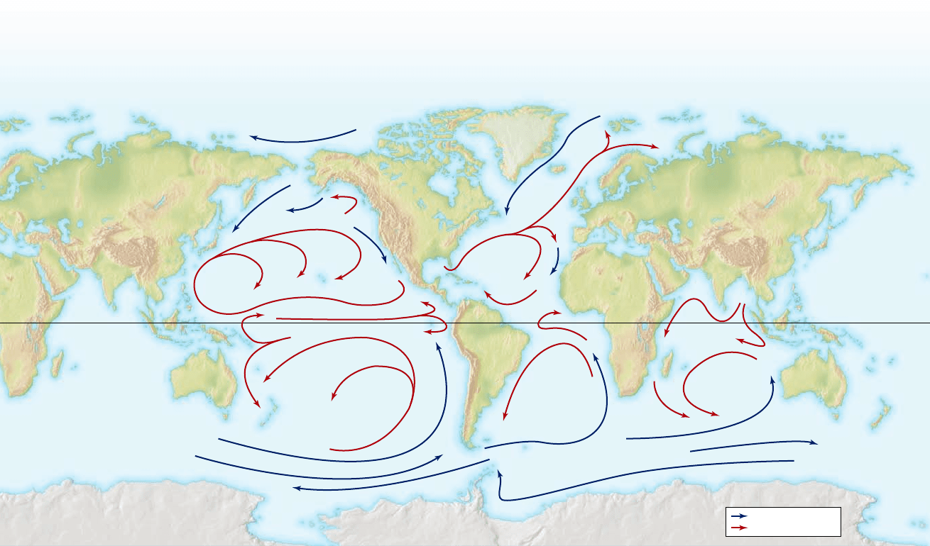
Figure 59.4
Ocean circulation. In the centers of several of the great ocean basins, surface water moves in great closed-curve patterns
called gyres. These water movements affect biological productivity in the oceans and sometimes profoundly affect the climate on adjacent
landmasses, as when the Gulf Stream brings warm water to the region of the British Isles.
turning from Europe and Africa to North America at latitudes
near the equator.
Water currents are affected by the Coriolis effect. Thus,
the Coriolis effect contributes to this clockwise closed-curve mo-
tion. Water flowing across the Atlantic toward Europe at midlati-
tudes tends to curve to the right and enters the flow from east to
west near the equator. This latter flow also tends to curve to its
right and enters the flow from west to east at midlatitudes. In the
south Atlantic Ocean, the same processes occur in a sort of mir-
ror image, and similar clockwise and counterclockwise gyres oc-
cur in the north and south Pacific Ocean as well.
Regional and local di erences a ect
terrestrial ecosystems
The environmental conditions at a particular place are affected
by regional and local effects of solar radiation, air circulation,
and water circulation, not just the global patterns of these pro-
cesses. In this section we look at just a few examples of regional
and local effects, focusing on terrestrial systems. These include
rain shadows, monsoon winds, elevation, and presence of micro-
climate factors.
Rain shadows
Deserts on land sometimes occur because mountain ranges in-
tercept moisture-laden winds from the sea. When air flowing
hemispheres, the winds blow westward as well as toward the
equator. The result (see figure 59.3) is that winds on both sides
of the equator—called the Trade Winds—blow out of the east
and toward the west.
Conversely, air masses moving north from 30° are mov-
ing more rapidly than underlying land surfaces and thus are
deflected again to their right, which in this case is eastward.
Similarly, in the southern hemisphere, air masses between 30°
and 60° are deflected eastward, to the left. In both hemispheres,
therefore, winds between 30° and 60° blow out of the west and
toward the east; these winds are called Westerlies.
Global currents are largely driven by winds
The major ocean currents are driven by the winds at the sur-
face of the Earth, which means that indirectly the currents are
driven by solar energy. The radiant input of heat from the Sun
sets the atmosphere in motion as already described, and then
the winds set the ocean in motion.
In the north Atlantic Ocean (figure 59.4) , the global
winds follow this pattern: Surface winds tend to blow out of
the east and toward the west near the equator, but out of the
west and toward the east at midlatitudes (between 30° and
60°). Consequently, surface waters of the north Atlantic Ocean
tend to move in a giant closed curve—called a gyre—flowing
from North America toward Europe at midlatitudes, then re-
chapter
59
The Biosphere
1233www.ravenbiology.com
rav32223_ch59_1230-1255.indd 1233rav32223_ch59_1230-1255.indd 1233 11/20/09 2:44:21 PM11/20/09 2:44:21 PM
Apago PDF Enhancer
Pacific
Ocean
Arid
desert
W
i
n
d
d
i
r
e
c
t
i
o
n
Moist
Rain
shadow
Sierra
Nevada
Sea level
3500 m
Elevation
Elevation
Equator 0°
Equator 0°
90°
90°N
Latitude
Latitude
Tundra
Tundra
Taiga
Taiga
Temperate forest
Temperate forest
Polar ice
Polar ice
Tropical rain forest
Tropical
rain forest
90°S
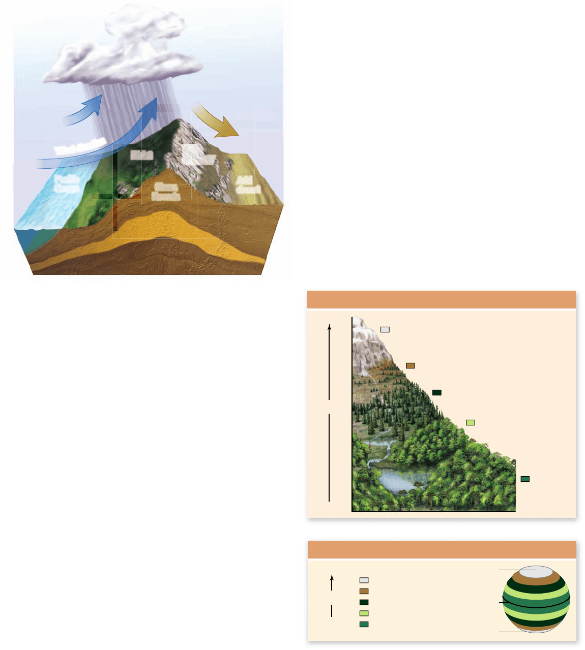
Figure 59.5
The rain shadow e ect exempli ed in
California. Moisture-laden winds from the Paci c Ocean rise and
are cooled when they encounter the Sierra Nevada Mountains. As
the moisture-holding capacity of the air decreases at colder, higher
altitudes, precipitation occurs, making the seaward-facing slopes of
the mountains moist; tall forests occur on those slopes, including
forests that contain the famous giant sequoias (Sequoiadendron
giganteum). As the air descends on the eastern side of the mountain
range, its moisture-holding capacity increases again, and the air
picks up moisture from its surroundings. As a result, the eastern
slopes of the mountains are arid, and rain shadow deserts sometimes
occur.
Figure 59.6
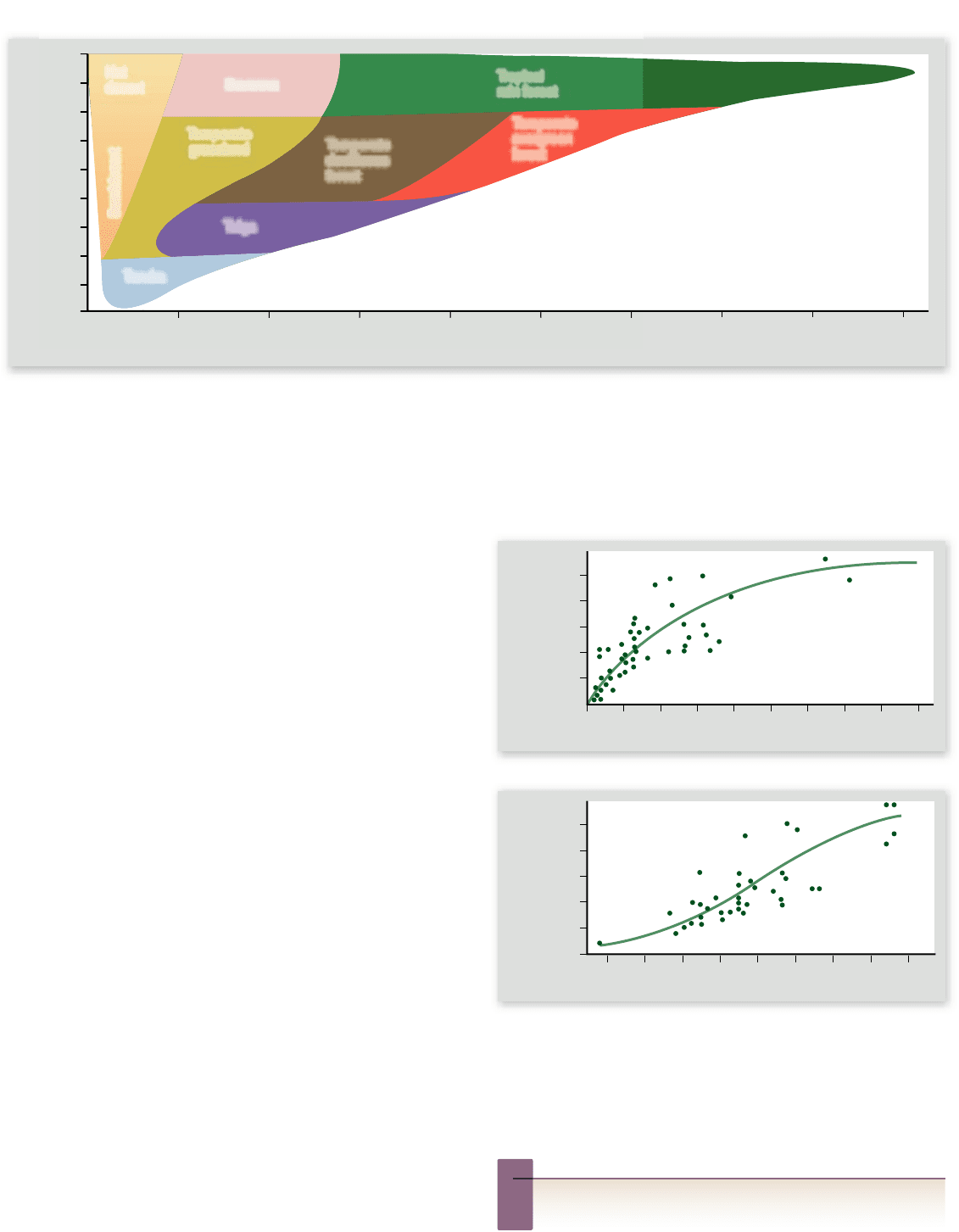
Elevation a ects the distribution of biomes
in much the same manner as latitude does. Biomes that
normally occur far north of the equator at sea level also occur in the
tropics at high mountain elevations. Thus, on a tall mountain in the
tropics, one might see a sequence of biomes like the one illustrated
above. In North America, a 1000-m increase in elevation results in a
temperature drop equal to that of an 880-km increase in latitude.
but during winter the landmass cools more than the oceans.
The consequence is that winds tend to blow off the water into
the interior of the Asian continent in summer, particularly in
the region of the Indian Ocean and western tropical Pacific
Ocean. These winds reverse to flow off the continent out over
the oceans in winter. These seasonally shifting winds are called
the monsoons. They affect rainfall patterns, and their duration
and strength can spell the difference between food sufficiency
and starvation for hundreds of millions of people in the region
each year.
Elevation
Another significant regional pattern is that in mountainous
regions, temperature and other conditions change with el-
evation. At any given latitude, air temperature falls about
6°C for every 1000-m increase in elevation. The ecological
consequences of the change of temperature with elevation
are similar to those of the change of temperature with lati-
tude (figure 59.6).
landward from the oceans encounters a mountain range
(figure 59.5), the air rises, and its moisture-holding capacity de-
creases because it becomes cooler at higher altitude, causing
precipitation to fall on the mountain slopes facing the sea.
As the air—stripped of much of its moisture—then de-
scends on the other side of the mountain range, it remains dry
even as it is warmed, and as it is warmed its moisture-holding
capacity increases, meaning it can readily take up moisture from
soils and plants.
One consequence is that the two slopes of a mountain
range often differ dramatically in how moist they are; in
California, for example, the eastern slopes of the Sierra
Nevada Mountains—facing away from the Pacific Ocean—
are far drier than the western slopes. Another consequence
is that a desert may develop on the dry side, the Mojave
Desert being an example. The mountains are said to pro-
duce a rain shadow.
Monsoons
The continent of Asia is so huge that heating and cooling of its
surface during the passage of the seasons causes massive re-
gional shifts in wind patterns. During summer, the surface of
the Asian landmass heats up more than the surrounding oceans,
1234
part
VIII
Ecology and Behavior
rav32223_ch59_1230-1255.indd 1234rav32223_ch59_1230-1255.indd 1234 11/20/09 2:44:22 PM11/20/09 2:44:22 PM
Apago PDF Enhancer
polar ice mountain zone warm, moist evergreen forest
tropical monsoon forest
chaparral semidesert
tundra
taiga
temperate deciduous forest
temperate evergreen forest tropical rain forest
temperate grassland
savanna
desert
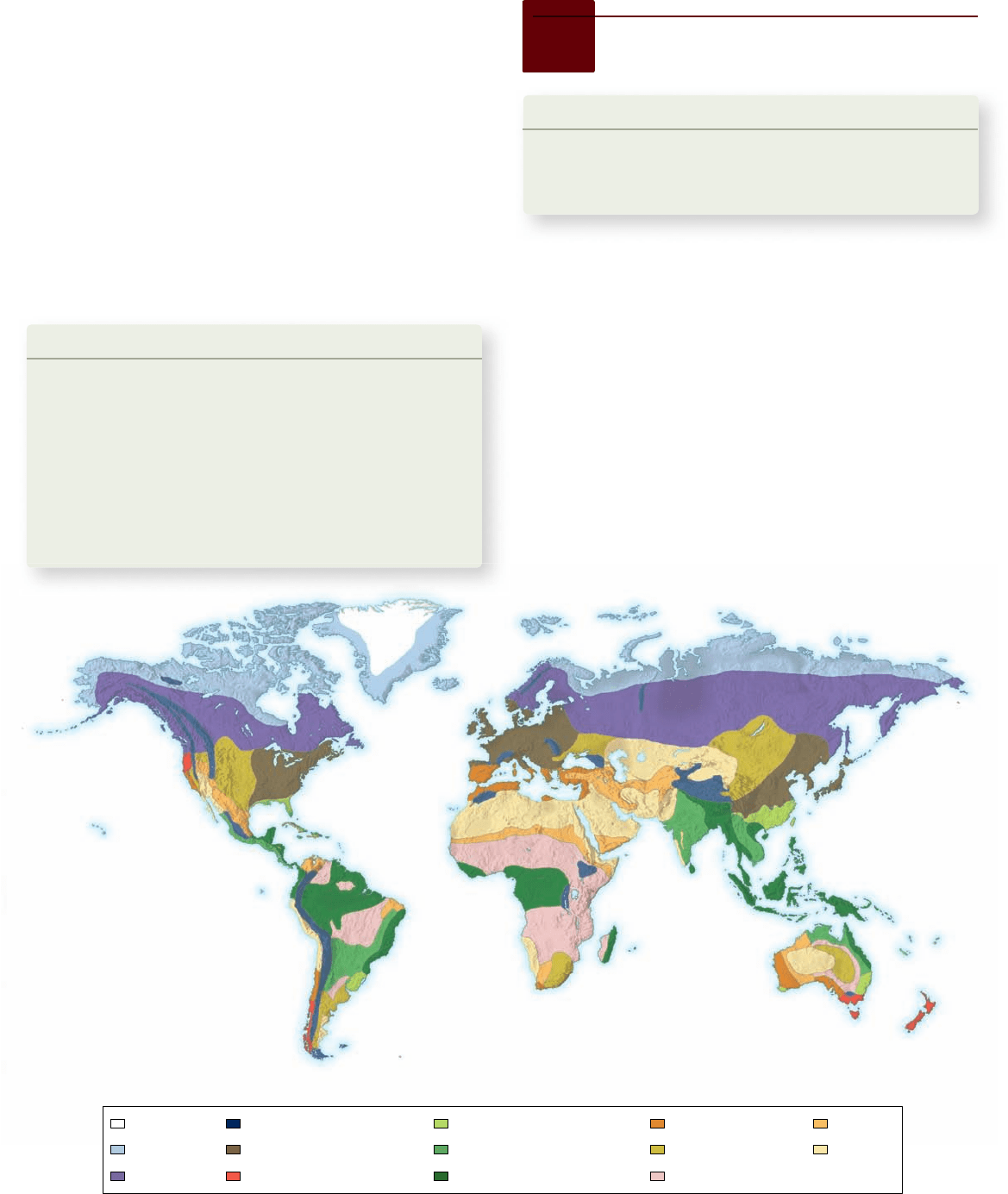
Figure 59.7
The distributions of biomes. Each biome is similar in vegetational structure and appearance wherever it occurs.
Microclimates
Conditions also vary in significant ways on very small spatial
scales. For example, in a forest, a bird sitting in an open patch
may experience intense solar radiation, a high air temperature,
and a low humidity, even while a mouse hiding under a log
10 feet away may experience shade, a cool temperature, and air
saturated with water vapor. Such highly localized sets of cli-
matic conditions are called microclimates.
In some cases, species avoid competing by adapting to use
different microclimates. Sympatric salamanders, for example,
may be specialized for the different levels of moisture found in
different parts of the habitat.
Learning Outcomes Review 59.1
More intense solar heating of some global regions relative to others sets
up global patterns of atmospheric circulation, which in turn cause global
patterns of water circulation in the oceans. The Coriolis eff ect is caused by
the Earth’s spin beneath the moving air masses of the atmosphere. These
patterns—plus seasonal changes—strongly aff ect the conditions that exist
for living organisms in diff erent parts of the world. In general, temperature
declines as altitude or latitude increases.
■ How would global air movement patterns be different if
the Earth turned in the opposite direction?
59.2
Earth’s Biomes
Learning Outcomes
Define biome.1.
Explain the primary factors that determine which type of 2.
biome is found in a particular place.
Biomes are major types of ecosystems on land. Each biome has
a characteristic appearance and is distributed over wide areas of
land defined largely by sets of regional climatic conditions.
Biomes are named according to their vegetational structures,
but they also include the animals that are present.
As you might imagine from the broad definition given for
biomes, there are a number of ways to classify terrestrial eco-
systems into biomes. Here we recognize eight principal biomes:
(1) tropical rain forest, (2) savanna, (3) desert, (4) temperate
grassland, (5) temperate deciduous forest, (6) temperate ever-
green forest, (7) taiga, (8) tundra.
Six additional biomes recognized by some ecologists are:
polar ice, mountain zone, chaparral, warm moist evergreen for-
est, tropical monsoon forest, and semidesert. Other ecologists
lump these six with the eight major ones. Figure 59.7 shows the
distributions of all 14 biomes.
chapter
59
The Biosphere
1235www.ravenbiology.com
rav32223_ch59_1230-1255.indd 1235rav32223_ch59_1230-1255.indd 1235 11/20/09 2:44:25 PM11/20/09 2:44:25 PM
Apago PDF Enhancer
50
–15
–10
–5
0
5
10
15
20
25
30
100
Tundra
Taiga
Hot
desert
Semidesert
Temperate
grassland
Savanna
Tropical
rain forest
Temperate
deciduous
forest
Temperate
evergreen
forest
150 200 250
Mean Annual Precipitation (cm)
Mean Annual Temperature (⬚C)
300 350 400 450
a.
b.
50 0 100 200
Precipitation (cm/year)
Productivity (g/m
2
/year)
300 400
500
1000
1500
2000
2500
Productivity (g/m
2
/year)
Temperature (⬚C)
–10 0 –5 5 15 10 25 20 30
500
0
1000
1500
2000
2500
Figure 59.8
Predictors of biome distribution. Temperature and precipitation are quite useful predictors of biome distribution,
although other factors sometimes also play critical roles.
Figure 59.9
The correlations of primary productivity
with precipitation and temperature. The net primary
productivity of ecosystems at 52 locations around the globe
correlates signi cantly with (a) mean annual precipitation and (b)
mean annual temperature.
Inquiry question
?
Why might you expect primary productivity to increase with
increasing precipitation and temperature?
Biomes are defined by their characteristic vegetational
structures and associated climatic conditions, rather than by
the presence of particular plant species. Two regions assigned
to the same biome thus may differ in the species that dominate
the landscape. Tropical rain forests around the world, for ex-
ample, are all composed of tall, lushly vegetated trees, but the
tree species that dominate a South American tropical rain for-
est are different from those in an Indonesian one. The similar-
ity between such forests results from convergent evolution (see
chapter 21).
Temperature and moisture often
determine biomes
In determining which biomes are found where, two key envi-
ronmental factors are temperature and moisture. As seen in
figure 59.8 , if you know the mean annual temperature and
mean annual precipitation in a terrestrial region, you often can
predict the biome that dominates. Temperature and moisture
affect ecosystems in a number of ways. One reason they are so
influential is that primary productivity is strongly correlated
with them, as described in the preceding chapter (figure 59.9 ).
Different places that are similar in mean annual tempera-
ture and precipitation sometimes support different biomes, in-
dicating that temperature and moisture are not the only factors
that can be important. Soil structure and mineral composition
(see chapter 39) are among the other factors that can be influ-
ential. The biome that is present may also depend on whether
the conditions of temperature and precipitation are strongly
seasonal or relatively constant.
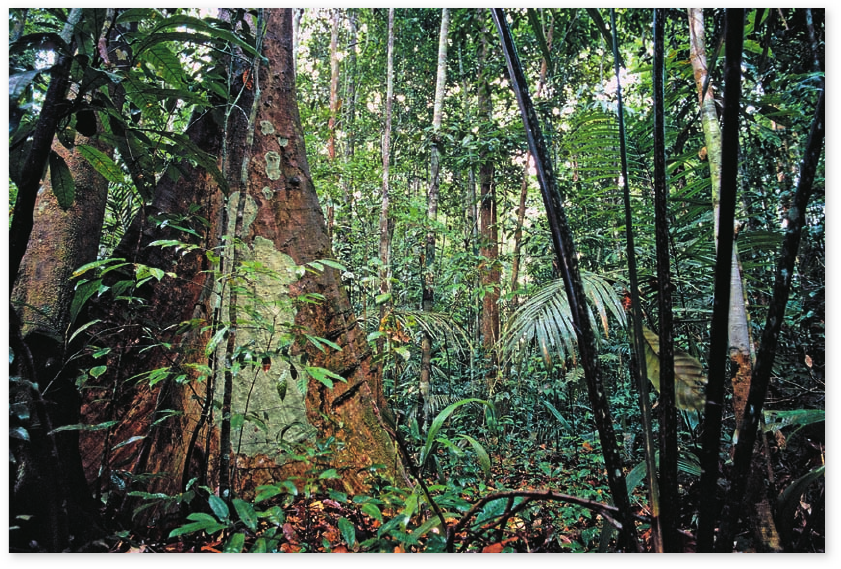
Tropical rain forests are highly productive
equatorial systems
Tropical rain forests, which typically require 140 to 450 cm of
rain per year, are the richest ecosystems on land (figure 59.10) .
1236
part
VIII
Ecology and Behavior
rav32223_ch59_1230-1255.indd 1236rav32223_ch59_1230-1255.indd 1236 11/20/09 2:44:28 PM11/20/09 2:44:28 PM
Apago PDF Enhancer
Figure 59.10
Tropical rainforest .
They are very productive because they enjoy the advantages of
both high temperature and high precipitation (see figure 59.9).
They also exhibit very high biodiversity, being home to at least
half of all the species of terrestrial plants and animals—over
2 million species! In a single square mile of Brazilian rain forest,
there can be 1200 species of butterflies—twice the number found
in all of North America. Tropical rain forests recycle nutrients
rapidly, so their soils often lack great reservoirs of nutrients.
Savannas are tropical grasslands
with seasonal rainfall
The savannas are tropical or subtropical grasslands, often dot-
ted with widely spaced trees or shrubs. On a global scale, savan-
nas often occur as transition ecosystems between tropical rain
forests and deserts; they are characteristic of warm places where
annual rainfall (50–125 cm) is too little to support rain forest,
but not so little as to produce desert conditions.
Rainfall is often highly seasonal in savannas. The Seren-
geti ecosystem in East Africa is probably the world’s most fa-
mous example of the savanna biome. In most of the Serengeti,
no rain falls for many months of the year, but during other
months rain is abundant. The huge herds of grazing animals in
the ecosystem respond to the seasonality of the rain; a number
of species migrate away from permanently flowing rivers only
during the months when rain falls.
Deserts are regions with little rainfall
Deserts are dry places where rain is both sparse (annual rainfall
often less than 25–40 cm) and unpredictable. The unpredict-
ability means that plants and animals cannot depend on experi-
encing rain even once each year. As mentioned earlier, many of
the largest deserts occur at latitudes near 30°N and 30°S be-
cause of global air circulation patterns (see figure 59.3). Other
deserts result from rain shadows (see figure 59.5).
Vegetation is sparse in deserts, and survival of both plants
and animals depends on water conservation. Many desert or-
ganisms enter inactive stages during rainless periods. To avoid
extreme temperatures, small desert vertebrates often live in
deep, cool, and sometimes even somewhat moist burrows. Some
emerge only at night. Among large desert animals, camels drink
large quantities of water when it is available and then conserve
it so well that they can survive for weeks without drinking.
Oryxes (large, desert-dwelling antelopes) survive opportunisti-
cally on moisture in leaves or roots that they dig up, as well as
drinking water when possible.
Temperate grasslands have rich soils
Halfway between the equator and the poles are temperate re-
gions where rich temperate grasslands grow. These grasslands,
also called prairies, once covered much of the interior of North
America, and they were widespread in Eurasia and South Amer-
ica as well.
The roots of perennial grasses characteristically penetrate
far into the soil, and grassland soils tend to be deep and fertile.
Temperate grasslands are often highly productive when con-
verted to agricultural use, and vast areas have been transformed
in this way. In North America prior to this change in land use,
huge herds of bison and pronghorn antelope in hab ited the
temperate grasslands, migrating seasonally as resources changed
over the course of the year. Natural temperate grasslands are
one of the biomes adapted to periodic fire and therefore need
fires to prosper.
chapter
59
The Biosphere
1237www.ravenbiology.com
rav32223_ch59_1230-1255.indd 1237rav32223_ch59_1230-1255.indd 1237 11/20/09 2:44:28 PM11/20/09 2:44:28 PM
Apago PDF Enhancer
The taiga is one of the largest biomes on Earth. The winters
where taiga occurs are severely long and cold, and most of the
limited precipitation falls in the summer. Many large herbivores,
including elk, moose, and deer, plus carnivores such as wolves,
bears, lynx, and wolverines, are characteristic of the taiga.
Tundra is a largely frozen treeless
area with a short growing season
In the far north, at latitudes above the taiga but south of the
polar ice, few trees grow. The landscape that occurs in this
band, called tundra, is open, windswept, and often boggy. This
enormous biome covers one-fifth of the Earth’s land surface.
Little rain or snow falls. Permafrost—soil ice that persists
throughout all seasons—usually exists within a meter of the
ground surface.
What trees can be found are small and mostly confined to
the margins of streams and lakes. Large grazing mammals, in-
cluding musk-oxen and reindeer (caribou), and carnivores such
as wolves, foxes, and lynx, live in the tundra. Populations of
lemmings (a small rodent native to the Arctic) rise and fall dra-
matically, with important consequences for the animals that
prey on them.
Learning Outcomes Review 59.2
Major types of ecosystems called biomes can be distinguished in diff erent
climatic regions on land. These biomes are much the same wherever they
are found on the Earth. Annual mean temperature and precipitation are
eff ective predictors of biome type; however, the range of seasonal variation
and the soil characteristics of a region also come into play.
■ Why do different biomes occur at different latitudes?
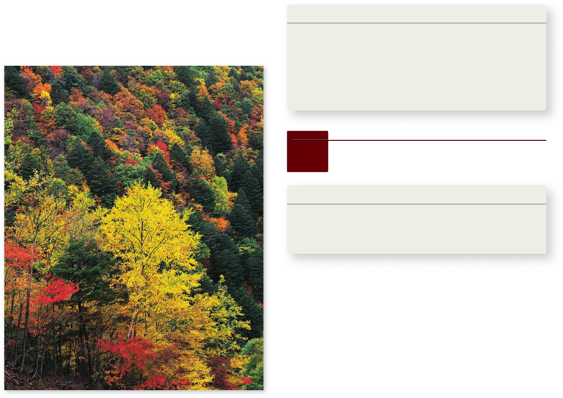
Temperate deciduous forests are adapted
to seasonal change
Mild but seasonal climates (warm summers and cold winters),
plus plentiful rains, promote the growth of temperate decidu-
ous forests in the eastern United States, eastern Canada, and
Eurasia (figure 59.11) . A deciduous tree is one that drops its
leaves in the winter. Deer, bears, beavers, and raccoons are fa-
miliar animals of these forests.
Temperate evergreen forests are coastal
Temperate evergreen forests occur along coastlines with
temperate climates, such as in the northwest of the United
States. The dominant vegetation includes trees, such as spruces,
pines, and redwoods, that do not drop their leaves (thus, they
are ever green).
Taiga is the northern forest
where winters are harsh
Taiga and tundra (described next) differ from other biomes in
that both stretch in great unbroken circles around the entire
globe (see figure 58.7). The taiga consists of a great band of
northern forest dominated by coniferous trees (spruce, hem-
lock, and fir) that retain their needle-like leaves all year long.
Figure 59.11
Temperate deciduous forest.
59.3
Freshwater Habitats
Learning Outcomes
Define photic zone.1.
Explain what causes spring and fall overturns in lakes.2.
Distinguish between eutrophic and oligotrophic lakes.3.
Of the major habitats, fresh water covers by far the smallest
percentage of the Earth’s surface: Only 2%, compared with
27% for land and 71% for ocean. The formation of fresh water
starts with the evaporation of water into the atmosphere, which
removes most dissolved constituents, much like distillation
does. When water falls back to the Earth’s surface as rain or
snow, it arrives in an almost pure state, although it may have
picked up biologically significant dissolved or particulate mat-
ter from the atmosphere.
Freshwater wetlands—marshes, swamps, and bogs—rep-
resent intermediate habitats between the freshwater and ter-
restrial realms. Wetlands are highly productive (see figure 58.11).
1238
part
VIII
Ecology and Behavior
rav32223_ch59_1230-1255.indd 1238rav32223_ch59_1230-1255.indd 1238 11/20/09 2:44:31 PM11/20/09 2:44:31 PM
Apago PDF Enhancer
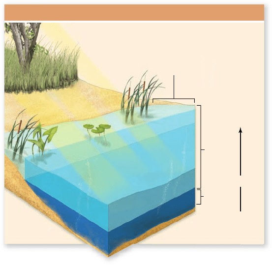
Productivity
Littoral
zone
Photic
zone
Aphotic
zone
Lake Zones and Productivity
Figure 59.12
Light in a lake. The intensity of the sunlight
available for photosynthesis decreases with depth in a lake.
Consequently, only some of the upper waters—termed the photic
zone—receive suf cient light for the net primary productivity of
phytoplankton to be positive. The depth of the photic zone depends
on how cloudy the water is. The shallows at the edge of a lake are
called the littoral zone. They are well-illuminated to the bottom, so
rooted plants and bottom algae can thrive there.
They also play key additional roles, such as acting as water stor-
age basins that moderate flooding.
Primary production in freshwater bodies is carried out by
single-celled algae (phytoplankton) floating in the water, by al-
gae growing as films on the bottom, and by rooted plants such
as water lilies. In addition, a considerable amount of organic
matter—such as dead leaves—enters some bodies of fresh wa-
ter from plant communities growing on the land nearby.
Life in freshwater habitats depends
on oxygen availability
The concentration of dissolved oxygen (O
2
) is a major determi-
nant of the properties of freshwater communities. Oxygen dis-
solves in water just like sugar or salt does. Fish and other aquatic
organisms obtain the oxygen they need by taking it up from solu-
tion. The solubility of oxygen is therefore critically important.
In reality, oxygen is not very soluble in water. Conse-
quently, even when fresh water is fully aerated and at equilib-
rium with the atmosphere, the amount of oxygen it contains
per liter is only 5%, or less, of that in air. This means that, in
terms of acquiring the oxygen they need, freshwater organisms
have a far smaller margin of safety than air-breathing ones.
Oxygen is constantly added to and removed from any
body of fresh water. Oxygen is added by photosynthesis and by
aeration from the atmosphere, and it is removed by animals and
other heterotrophs. If a lot of decaying organic matter is pres-
ent in a body of water, the oxygen demand of the decay mi-
crobes can be high and affect other life forms. Under conditions
in which the rate of oxygen removal from water exceeds the
rate of addition, the concentration of dissolved oxygen can fall
so low that many aquatic animals cannot survive in it.
Lake and pond habitats change
with water depth
Bodies of relatively still fresh water are called lakes if large and
ponds if small. Water absorbs light passing through it, and the
intensity of sunlight available for photosynthesis decreases
sharply with increasing depth. In deep lakes, only water rela-
tively near the surface receives enough light for phytoplankton
to exhibit a positive net primary productivity (figure 59.12) .
Those waters are described as the photic zone.
The photic zone
The thickness of the photic zone depends on how much par-
ticulate matter is in the water. Water that is relatively free of
particulate matter and clear allows light to penetrate to a depth
of 10 m at sufficient intensity to support phytoplankton. Water
that is thick with surface algal cells or soil from erosion may not
allow light to penetrate very far before its intensity becomes
too diminished for algal growth.
The supply of dissolved oxygen to the deep waters of a
lake can be a problem because all oxygen enters any aquatic
system near its surface. In the still waters of a lake, mixing be-
tween the surface and deeper layers may not occur except oc-
casionally. When photosynthesis produces oxygen, it adds it to
the photic zone of the lake near the surface. Thermal stratifica-
tion commonly affects how readily oxygen enters the deep wa-
ters from the surface waters.
Thermal stratification
Thermal stratification is characteristic of many lakes and
large ponds. In summer, as shown at the bottom of figure 59.13 ,
water warmed by the Sun forms a layer known as the epilimnion
at the surface—because warm water is less dense than cold wa-
ter and tends to float on top. Colder, denser water, called the
hypolimnion, lies below. Between the warm and cold layers is a
transitional layer, the thermocline. Although here we are focus-
ing on fresh water, a similar thermal structuring of the water
column occurs also in many parts of the ocean.
In a lake, thermal stratification tends to cut off the oxygen
supply to the bottom waters; a consequence of the stratification
is that the upper waters that receive oxygen do not mix with the
bottom waters. The concentration of oxygen at the bottom may
then gradually decline over time as the organisms living there
use oxygen faster than it is replaced. If the rate of oxygen use is
high, the bottom waters may run out of oxygen and become
oxygen-free before summer is over. Oxygen-free conditions, if
they occur, kill most (although not all) animals.
In autumn, the temperature of the upper waters in a strat-
ified lake drops until it is about the same as the temperature of
the deep waters. The densities of the two water layers become
similar, and the tendency for them to stay apart is weakened.
chapter
59
The Biosphere
1239www.ravenbiology.com
rav32223_ch59_1230-1255.indd 1239rav32223_ch59_1230-1255.indd 1239 11/20/09 2:44:37 PM11/20/09 2:44:37 PM
Apago PDF Enhancer
a. b.
Oligotrophic Lake Eutrophic Lake
4°
5°
6°
8°
18°
20°
22°
4°
4°
4°
4°
4°
2°
0°
4°
4°
4°
4°
4°
4°
4°
4°
4°
4°
4°
4°
4°
4°
Epilimnion
Thermocline
Hypolimnion
Winter
Spring Overturn
Midsummer
Fall Overturn
Figure 59.14
Oligotrophic and eutrophic lakes. a. Oligotrophic lakes are low in algal nutrients, have high levels of dissolved
oxygen, and are clear. b. Eutrophic lakes have high levels of algal nutrients and low levels of dissolved oxygen. Light does not penetrate deeply
in such lakes.
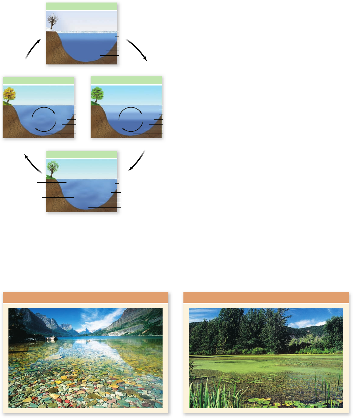
Figure 59.13
The annual cycle of thermal strati cation
in a temperate-zone lake. During the summer (lower diagram),
water warmed by the Sun (the epilimnion) oats on top of colder,
denser water (the hypolimnion). The lake is also thermally strati ed
in winter (upper diagram) when water that is near freezing or frozen
oats on top of water that is at 4°C (the temperature of greatest
density for fresh water). Strati cation is disrupted in the spring and
fall overturns, when the lake is at an approximately uniform
temperature and winds mix it from top to bottom.
Winds can then force the layers to mix, a phenomenon called
the fall overturn (see figure 59.13). High oxygen concentra-
tions are then restored in the bottom waters.
Chapter 2 discussed the unique properties of water. Fresh
water is densest when its temperature is 4°C, and ice, at 0°,
floats on top of this dense water. As a lake is cooled toward the
freezing point with the onset of winter, the whole lake first
reaches 4°C. Then, some water cools to an even lower tempera-
ture, and when it does, it becomes less dense and rises to the
top. Further cooling of this surface water causes it to freeze into
a layer of ice covering the lake. In spring, the ice melts, the
surface water warms up, and again winds are able to mix the
whole lake—the spring overturn.
Because temperature changes less over the course of
the year in the tropics, many lakes there do not experience
turnover. As a result, tropical lakes can have a permanent
thermocline with depletion of oxygen near the bottom.
Lakes di er in oxygen and nutrient content
Bodies of fresh water that are low in algal nutrients (such as ni-
trate or phosphate) and low in the amount of algal material per
unit of volume are termed oligotrophic. Such waters are often
crystal clear. Oligotrophic streams and rivers tend to be high in
dissolved oxygen because the movement of the flowing water
aerates them; the small amount of organic matter in the water
means that oxygen is used at a relatively low rate. Similarly, oli-
gotrophic lakes and ponds tend to be high in dissolved oxygen at
all depths all year because they also have a low rate of oxygen
use. Because the water is relatively clear, light can penetrate the
waters readily, allowing photosynthesis to occur through much
of the water column, from top to bottom (figure 59.14).
Eutrophic bodies of water are high in algal nutrients and
often populated densely with algae. They are more likely to be
low in dissolved oxygen, especially in summer. In a eutrophic
body of water, decay microbes often place high demands on the
1240
part
VIII
Ecology and Behavior
rav32223_ch59_1230-1255.indd 1240rav32223_ch59_1230-1255.indd 1240 11/20/09 2:44:38 PM11/20/09 2:44:38 PM

Apago PDF Enhancer
Pelagic
zone
Continental
shelf
Intertidal
region
Photic
zone
Benthic
zone
Neritic
zone
Figure 59.15
Basic concepts and terminology used in
describing marine ecosystems. The continental shelf is the
submerged edge of the continent. The waters over it are termed
neritic and, on a worldwide average basis, are only 130 m deep at
their deepest. The region where the tides rise and fall along the
shoreline is called the intertidal region. The bottom is called the
benthic zone, whereas the water column in the open ocean is called
the pelagic zone. The photic zone is the part of the pelagic zone in
which enough light penetrates for the phytoplankton to have a
positive net primary productivity. The vertical scale of this drawing
is highly compressed; whereas the outer edge of the continental
shelf is 130 m deep, the open ocean in fact averages 35 times deeper
(4000–5000 m deep).
oxygen available because when thick populations of algae die,
large amounts of organic matter are made available for decom-
position. Moreover, light does not penetrate eutrophic waters
well because of all the organic matter in the water; photosyn-
thetic oxygen addition is therefore limited to just a relatively
thin layer of water at the top.
Human activities have often transformed oligotrophic
lakes into eutrophic ones. For example, when people overfer-
tilize their lawns or fields , nitrate and phosphate from the fer-
tilizers wash off into local water systems. Lakes that receive
these nutrients become more eutrophic. A consequence is that
the bottom waters are more likely to become oxygen-free dur-
ing the summer. Many species of fish that are characteristic of
oligotrophic lakes, such as trout, are very sensitive to oxygen
deprivation. When lakes become eutrophic, these species of
fish disappear and are replaced with species like carp that can
better tolerate low oxygen concentrations. Lakes can return
toward an oligotrophic state over time if steps are taken to
eliminate the addition of excess nitrates, phosphates, and for-
eign organic matter such as sewage.
Learning Outcomes Review 59.3
The photic zone is the layer near the surface into which light penetrates.
Photosynthesis can occur only in the photic zone. Thermal stratifi cation is a
major determinant of oxygen levels. In temperate lakes, mixing of diff erent
layers occurs when the layers reach the same temperature in spring and
fall, and winds can cause the layers to mix. This overturn prevents oxygen
depletion near the lake bottom. Eutrophic lakes are high in nutrients for
algae but are low in dissolved oxygen; oligotrophic lakes are low in nutrients
but high in dissolved oxygen at all depths.
■ Why do tropical lakes often not experience seasonal
turnover, and what effect is this likely to have on the
ecosystems of these lakes?
Learning Outcomes
Know the different marine habitats.1.
Explain why El Niño events occur.2.
About 71% of the Earth’s surface is covered by ocean. Near the
coastlines of the continents are the continental shelves, where
the water is not especially deep (figure 59.15) ; the shelves, in
essence, represent the submerged edges of the continents.
Worldwide, the shelves average about 80 km wide, and the
depth of the water over them increases from 1 m to about
130 m as one travels from the coast toward the open ocean.
Beyond the continental shelves, the depth suddenly be-
comes much greater. The average depth of the open ocean is
4000 to 5000 m, and some parts—called trenches—are far
deeper, reaching 11,000 m in the Marianas Trench in the west-
ern Pacific Ocean.
59.4
Marine Habitats
In most of the ocean, the principal primary producers
are phytoplankton floating in the well-lit surface waters. A
revolution is currently underway in scientific understanding
of the limiting nutrients for ocean phytoplankton (see
chapter 58). Primary production by the phytoplankton is
presently understood to be nitrogen-limited in about two-
thirds of the world’s ocean, but iron-limited in about one-
third. The principal known iron-limited areas are the great
Southern Ocean surrounding Antarctica, parts of the equato-
rial Pacific Ocean, and parts of the subarctic, northeast Pa-
cific Ocean. Where the water is shallow along coastlines,
primary production is carried out not just by phytoplankton
but also by rooted plants such as seagrasses and by bottom-
dwelling algae, including seaweeds.
The world’s ocean is so vast that it includes many dif-
ferent types of ecosystems. Some, such as coral reefs and es-
tuaries, are high in their net primary productivity per unit of
area (see figure 58.11), but others are low in productivity per
unit area. Ocean ecosystems are of four major types: open
oceans, continental shelf ecosystems, upwelling regions, and
deep sea.
chapter
59
The Biosphere
1241www.ravenbiology.com
rav32223_ch59_1230-1255.indd 1241rav32223_ch59_1230-1255.indd 1241 11/20/09 2:44:41 PM11/20/09 2:44:41 PM