Gates A.E., Ritchie D. Encyclopedia of Earthquakes and Volcanoes
Подождите немного. Документ загружается.

180 people. A strong aftershock occurred approximately 90
minutes after the main shock, and aftershocks continued for
weeks afterward. Another earthquake, in Tabas in September
1978, killed 25,000 and was suspected of having some link to
the underground testing of a Soviet nuclear device some hours
before near Semipalatinsk (now Semey) in Siberia, approxi-
mately 1,500 miles (2,414 km) away. Believed to have yielded
10 megatons, the Russian bomb test was unusually powerful
and allegedly was set off at a shallow depth of only about
one mile (1.61 km). The coincidence between the test and the
earthquake was remarkable, as was the unusual set of char-
acteristics observed in the Iranian earthquake. It was very
shallow (centered only about 10 miles (16 km) underground)
and reportedly had no aftershocks. Also, a peculiar report
from Iran concerned access to the site of the earthquake. As a
rule, seismologists are admitted to be affected area follow-
ing a large earthquake to assess the damage; but in this case,
access was denied, leading some observers to wonder if there
was something especially sensitive and deserving of secrecy
that had occurred at Tabas. Other recent earthquakes in
Iran include Dasht-e Bayaz in 1968, in which some 12,000
were killed; Gilan in 1990, which had a death toll of
over 50,000; and the Bam earthquake of 2003, in which the
loss of life was 43,200. Although the death toll from these
recent earthquakes is far less than the hundreds of thousands
reported of those from antiquity, they are still among the
deadliest in modern times. With the frequency of these deadly
quakes, it is no exaggeration to dub Iran as one of the seismi-
cally most dangerous countries on Earth.
Irazu volcano, Costa Rica The stratovolcano Irazu
has a double crater and has undergone explosive erup-
tions some 23 times since 1723. Eruptions between 1963 and
1965, the most recent activity generated many ashfalls that
caused considerable harm to agriculture and affected the city
of San Juan. Resulting lahars killed at least 40 people and
destroyed 400 houses.
Irian Jaya earthquake, Indonesia On February 17, 1996,
an earthquake of magnitude 8.1 occurred. At least 108
people were killed and 423 were injured. There were 5,043
houses destroyed or damaged in the epicentral area. tsu-
namis generated from the earthquake reached heights of 22
feet (7 m).
Ischia volcano, Italy The volcanic island Ischia stands close
to Vesuvius, in the Bay of Naples, and has been active since
earliest historical times. Resurgent uplift at Ischia, similar to
that observed at Iwo Jima, had led some observers to specu-
late that Ischia has a caldera, although this interpretation
is not certain. There has been considered long-term ground
deformation at Ischia. One sign of this deformation is the
site of a Roman metal foundry on the northeast side of the
island, now about 15 to 20 feet (5–6.5 m) underwater. On
the islands southern side, a beach has been uplifted almost
100 feet (30 m) in places above the present water level. At
one point on the island, thermal baths built in the late 18th
or early 19th century have risen up to approximately 20 feet
(6.5 m), at a rate of more than an inch (2 cm) per year, since
their construction. In the 20th century, the south side of the
island appears to have started subsiding, thus reversing the
earlier trend of uplift. At the same time, Monte Epomeo, the
highest point on the island, appears to be undergoing con-
tinuing uplift.
Although uplift at Ischia may be volcanic in origin, it
also is possible that tectonic activity is involved. Subsid-
ence at Ischia, however, is more difficult to explain in terms
of volcanic activity. Major explosive eruptions in prehistoric
times appear to have laid down the Tufo Verde, or “Green
Tuff,” more than 3,000 feet (914 m) thick. If a caldera does
exist at Ischia, it may have formed during the eruption that
deposited the Tufo Verde. An eruption around 470 b.c.
drove away a Syracusan colony on the island. Residents of
the island had to flee yet again in an eruption that occurred
between approximately 400 b.c. and 350 b.c. This eruption
is said to have followed earthquake activity. A tsunami may
have accompanied an eruption, possibly of Monte Epomeo,
around 350 b.c. Another eruption may have taken place in
91 b.c., although there is some question whether this erup-
tion involved Ischia, Vulsini, or Roccamonfina. The erup-
tive history of Ischia over the next thousand years is sketchy,
but eruptions appear to have occurred around a.d. 80, 180–
222, and 284–305. Approximately 700 people were killed
in a rockslide in a.d. 1228. There was considerable earth-
quake activity in 1302 as well as an explosive eruption and
a flow of lava. In either 1557 or 1559, an earthquake caused
a church at Campagnano to collapse. Another church in the
same community collapsed during an earthquake in 1762,
and a church at Rotaro was demolished in an earthquake
in 1767. In the community of Casamicciola (formerly Cam-
pagnano), several houses and seven of their occupants were
destroyed in a 1796 earthquake. Strong earthquakes shook
the island in 1827 and 1828. After one earthquake, residents
of the island slept outdoors for more than two weeks. Earth-
quakes occurred again at Ischia in 1841, 1863, and 1867.
Seismic events between 1881 and 1883 may have accompa-
nied an increase in the temperature of wells on the island, but
this is not certain. A moderate earthquake occurred in 1961.
island arc This is an arcuate (in map view), or crescent-
shaped, string of islands that forms at an ocean-ocean con-
vergent plate boundary. Island arcs are subduction
zones where oceanic crust is going beneath other oceanic
crust. The downgoing crust melts at a certain depth pro-
ducing vast quantities of magma. The magma rises through
the overlying mantle and crust and forms volcanoes on
the ocean floor behind the trench. The volcanoes grow into
islands. Alaska’s Aleutian Island chain is a familiar exam-
ple of an island arc among many others.
isoseismal seismologists evaluate the modified Mercalli
intensity of each earthquake for the area around each epicen-
ter. The highest intensities usually occur near the epicenter
and the lowest farther away. intensity numbers, I to as high
as XII, are determined for the locations evaluated. Seismolo-
gists then put contour lines on the map to separate the areas
with similar intensity numbers. These lines represent equal
intensities and are called isoseismal lines.
122 Irazu
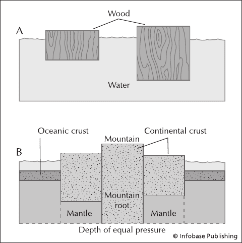
isostacy Lithospheric plates float on the soft, gumlike
asthenosphere. The depth at which the plates sink into the
asthenosphere is dependent upon the density and thickness of
the crust. These relations constitute isostasy. oceanic crust
is dense and sinks deeply into the asthenosphere. continen-
tal crust is light and floats higher. That is why the oceans
are on ocean crust—it is at a much lower elevation on the
planet and water goes to the lowest point. To support moun-
tain ranges, the continental crust must sink deeply into the
asthenosphere as well. Typical continental crust at sea level is
about 35 miles (56 km) thick. To support the 25,000–30,000-
foot (7,600–9,100 m) Himalayan Mountains, the crust thick-
ens to about 80 miles (129 km). Another example of isostasy
is glacial rebound. During the last ice age, a mile (1.6-km)
-thick sheet of ice extended from the Arctic to about New
York City. It was so heavy that it pressed the crust deeper
into the asthenosphere. After the ice melted and retreated the
land very slowly rose back up. Castles that were built on the
ocean in the Middle Ages are now one-quarter to a half-mile
(0.5–1 km) inland. Lake Champlain in New York is purely
freshwater, and yet there are whale bones in the sediments
from several thousand years ago. The lake was open to the
Saint Lawrence seaway after the glacier retreated but the
land rebounded and was elevated enough to cut off the lake
from the ocean.
Istanbul earthquakes, Turkey The great Turkish city of
Constantinople and its successor, Istanbul, were devastated
on several occasions by massive earthquakes. The city seems
to have been struck in blocks of earthquakes at various
points in its history. The first well-documented event was
on January 26, a.d. 447. It had an estimated Richter mag-
nitude of 7.3. and a modified Mercalli intensity of VIII.
This earthquake was responsible for extensive subsidence
and uplift to the point that ocean floor was exposed. There
was another large quake on September 25, a.d. 447, of esti-
mated magnitude 7.2 and intensity IX that was followed
by 90 days of strong aftershocks. Magnitude 6.5–7.0
events also occurred in 542, 554, and a.d. 557. All caused
great damage (VIII–IX on the modified Mercalli scale). The
a.d. 740 event on October 26 was a bit stronger, with a
Richter magnitude of 7.6 and modified Mercalli intensity
of IX and strong aftershocks for 12 months. There were
intermediate events on March 17, 780; May 23, 862; Janu-
ary 9, 869; October 26, 989; September 23, 1063; March
11, 1231; June 11, 1296; and October 18, 1343, for which
there is little information.
The earthquake of September 10, 1509, on the other
hand, was considerable. It was estimated to have had a mag-
nitude of 7.4 on the Richter scale and an intensity of X on the
modified Mercalli scale. It was said that not a single house
in Istanbul was left undamaged. The city’s fortifications were
also severely damaged, with 49 towers destroyed. Some 109
mosques were ruined. Great fissures opened in the city,
and sand boils were common. Subsidence along the coast
resulted in flooding, and reports of large waves suggest that
tsunamis may have formed. Within Istanbul, at least 5,000
people lost their lives and more than 10,000 were injured.
The death toll for the entire event was estimated at 13,000
people.
Istanbul was again struck on May 22, 1766, at 5:30 a.m.
The earthquake had an estimated magnitude of 7.3 on the
Richter scale and a maximum intensity of IX on the modi-
fied Mercalli scale. The quake was said to have produced a
significant tsunami in the Sea of Marmara that ravaged the
coast and especially the city of Izmit. The death toll for this
event was estimated at greater than 4,500 people.
Italy The Italian Peninsula and its nearby islands and
waters are home to a number of famous volcanoes, nota-
bly Vesuvius, which has erupted on numerous occasions
within historical times and caused widespread destruction,
including the ruin of the cities of Pompeii and Hercula-
neum. The other major and famous volcano is Mount Etna
in Sicily. It, too, is very commonly active. Eruption types
are named after two Italian volcanoes, Stromboli and
Vulcano. Earthquake activity is also frequently destructive
in Italy, which is located in the seismically active Medi-
terranean basin. Between two earthquakes in Calabria
in 1783 and 1857, more than 110,000 people were killed.
Because of the dense population and the large amount
of ancient ruins that are susceptible to being broken and
destroyed, earthquakes in Italy are typically well covered
by the press. geothermal energy has been harnessed in
Italy. The Messina earthquake of 1908 was perhaps the
worst natural disaster in European history. Some 160,000
people were killed by the terrible quake and subsequent
tsunami, leaving Messina to be dubbed “city of the dead.”
Illustrations of the principle of isostasy. (A) Shows two blocks of wood
of different sizes illustrating the large amount of block required below
the water surface to produce height above the water. (B) Shows the large
amount of continent required in the mantle to support mountain ranges.
Italy 123
The Avezzano earthquake of 1915 was also devastating,
with a death toll of 30,000–35,000. These frequent and
horrifying events make Italy, by far, the most dangerous
country in Europe in terms of natural disasters.
See also Ischia; Larderello; Phlegraean Fields;
Roccamonfina; Vulsini.
Iturup earthquake, Kuril Islands, Russia On October 4,
1994, an earthquake of magnitude 8.2 occurred. Only 10
people were killed, owing to the sparse population in the area.
However, resulting tsunamis affected coastlines throughout
the Pacific Ocean. Wave heights ranged from 12 feet (3.5 m)
to eight inches (17 cm), depending upon location.
Iwo Jima caldera, Japan This small island, a famous
World War II battleground, occupies a submerged caldera.
The name Iwo Jima means “Sulfur Island.” Much of the
island is taken up by Motoyama, a volcanic cone with a high
proportion of tuff to lava. Mount Suribachi, at the southern
tip of the island, is made up of tuff and lava. Iwo Jima has a
history of phreatic eruptions reaching back to 1889, and
the barrenness of certain pumice deposits seen on the island
during World War II indicated the deposits were reason-
ably fresh. fumaroles are abundant on Iwo Jima and tend
to be very hot; one test drilling had to be suspended because
the intense heat ruined the drill bits. The island appears to
have undergone dramatic uplift over the past several hun-
dred years. Estimates put the rate of uplift at perhaps seven
or eight inches (18–20 cm) per year. It is not clear whether
the uplift at Iwo Jima may represent an early indication of
another caldera-generating eruption in the future. Iwo Jima
has had at least 10 historical eruptions. The most recent erup-
tion was in 1982 and was small and phreatic.
Izalco volcano, El Salvador A young stratovolcano on
the south side of the Santa Ana volcano in the western part
of the country. It has had semicontinuous eruptions since
1770. In total, there have been at least 51 eruptive periods.
These eruptions consist of small explosions, ejection of cinder
showers and bombs and lava flows from lateral vents. As
the result of the activity, it came to be known as the Light-
house of the Pacific. However, right after a hotel was built
to accommodate tourists coming to see this attraction, activ-
ity waned and it is quiet today. Its last eruption was a small
flank eruption in 1966.
See also Coatepeque.
Izmir earthquake, Turkey The ancient city of Smyrna, now
called Izmir, was destroyed several times by earthquakes.
One of the most devastating of these earthquakes occurred
at 11:45 a.m. on July 10, 1688. The shock lasted for 20–30
seconds and had an estimated magnitude of 6.8. The inten-
sity was estimated at X on the modified Mercalli scale. The
shaking destroyed 75% of all buildings, leaving only three of
17 mosques standing, and fire ravaged the city. subsidence
east of the city was so great that the fort of Sacak Burnu,
which had previously been situated on a peninsula, wound up
on an islet separated from the mainland by a 100-foot (30-
m) stretch of sea. On average, the sea encroached the land by
24 inches (60 cm). More than 5,000 people lost their lives in
Smyrna, but the death toll for the entire event may have
reached 20,000.
Among the numerous other damaging earthquakes to
have struck the city of Smyrna, the only other one with such
a high death toll was in a.d. 688. It was said to have also
killed 20,000 people, but there are few details available.
Izmit earthquake, Turkey On August 17, 1999, there was
an earthquake of magnitude 7.4. At least 30,000 people
were killed and there was more than $6.5 billion in prop-
erty damage. However, the total economic impact ranged
between $10 and $20 billion. More than 50,000 people were
injured, and more than 600,000 were left homeless. It was
the largest and most deadly earthquake in Turkey in more
than 60 years. A maximum displacement of 16 feet (5 m)
of right-lateral strike-slip movement occurred along a 75-
mile (120-km) segment of the nearly vertical North Anato-
lian Fault. Izmit was one of 11 major earthquakes (larger
than magnitude 6.7) along some 621 miles (1,000 km) of the
North Anatolian Fault.
Izu-O
¯
shima caldera, Japan An island located near the
point where the Pacific crustal plate meets the Eurasian
and Philippine crustal plates, Izu-O
¯
shima is often active, and
the historical record of eruptions, mostly explosive but some
with lava flows as well, reaches back to the seventh cen-
tury a.d. There have been at least 74 eruptions in historic
times, the last of which was in 1990. Most of the eruptions
are Strombolian in nature. The caldera is less than three
miles (4.8 km) wide and contains a volcano, Miharayama,
with a summit crater some 450 feet (137 m).
Izu-O
¯
shima is known for the dramatic and periodic rise
and fall of the floor of Miharayama’s summit crater. The
crater floor has been known to rise and fall more than 1,200
feet (366 m) during 20 years. Periods of rising are correlated
with eruptions. Very strong earthquakes may follow these
episodes by several years. For example, uplift began in 1908,
followed by eruptions in 1912–14 and 1919; a powerful
earthquake occurred in 1923. Another episode of uplift began
in 1933; eruptions followed in 1950–51 and another major
earthquake in 1953. Yet another period of uplift started in
1963; Izu-O
¯
shima erupted in 1974 and again in 1976, and
a major earthquake is anticipated. It has been suggested that
tectonic forces are responsible for the dramatic up-and-
down motion of the crater floor. Tectonic activity, according
to this model, may squeeze an underground magma reservoir
(somewhat in the manner of a tube of toothpaste) and cause
the crater floor to rise; when pressure is relieved, the crater
floor then falls. Because Izu-O
¯
shima thus may serve as a nat-
ural indicator of tectonic stress, it is studied closely as a pos-
sible guide to future strong earthquakes in the Tokyo region.
Marked changes in the magnetic field have been observed
before and after eruptions at Izu-O
¯
shima. These changes may
be due to demagnetization of a reservoir of magma about
three miles (4.8 km) down.
See also plate tectonics.
124 Iturup
Izu Peninsula Japan The Izu Peninsula is located a few
miles south of Tokyo, at the point of intersection of the Eur-
asian, Philippine, and Pacific crustal plates and close
to Izu-O
¯
shima. Known for its strong seismic and volcanic
activity, the Izu Peninsula has numerous volcanic cones and
domes. Some of the domes are thought to have appeared
only about 3,000 years ago. The Kanto earthquake of 1923
occurred only a few miles north of the Izu Peninsula. Instabil-
ity on the Izu Peninsula in recent times may be due to move-
ment of magma underground.
Izu Peninsula 125
Japan The islands of the Japanese archipelago occupy one
of the most concentrated areas of seismic and volcanic activ-
ity in the world. The result of a collision between the Pacific
crustal plate to the east, the Eurasian crustal plate to
the west, and the Philippine plate to the south, the extraor-
dinary history of earthquakes and volcanism has had a pro-
found impact on the history of Japan. Time and again, cities
in Japan have been damaged heavily or destroyed entirely by
earthquakes and volcanic eruptions. Perhaps the most famous
earthquakes in Japanese history is the one that struck Tokyo
in 1923, killing more than 140,000 and destroying much of
the city.
Japan’s volcanoes are numerous and spectacular. One
of them, Mount Fuji, or Fuji-san, is located within sight
of Tokyo and has become a symbol of Japan. An interest-
ing feature of Mount Fuji is a set of lakes, Kawaguchi,
Yamanaka, Sai, Shooji, and Motosu at the foot of the moun-
tain; originally these separate lakes were a single large lake,
but eruptions produced lava flows that divided the lake into
five portions. Other notable volcanoes and calderas in
Japan include Asamayama, Aso, Bandai-San, Bayonnaise,
Izu-O
¯
shima, Sakurajima, Tarumai, Unzen, and Usu.
Japan is an excellent example of a chain of volcanoes
formed along subduction zones. Three volcanic arcs
intersect in Japan, the Kurile arc, the Izu-Bonin (Marianas)
arc, and the Ryuku arc. The volcanoes of the archipelago
are located 50–120 miles (80–195 km) west of the deep
ocean trench that marks the actual boundaries between the
crustal plates. The subduction of crustal rock and the forces
generated and released by that ongoing process create the
intense volcanism and seismicity of Japan. The tallest vol-
canoes in Japan, as a rule, are located along the eastern side
of the belt of volcanism, close to the subduction zone. Hot
springs and other geothermal phenomena are commonplace
in Japan; indeed, hot springs provide popular attractions
for vacationers in many years. Japan has several major vol-
canic zones:
1. Kirishima zone. This zone is located in the southern por-
tion of the Japanese islands.
2. Hakusan zone. Just to the north of the Kirishima zone, the
Hakusan zone lies along the southwestern coast of Japan
and includes portions of the southern island of Kyu¯shu¯
and the main island of Honshu¯.
3. Norikura zone. This small zone is located southwest of
Tokyo and incorporates portions of two mountain ranges,
known as the central Alps and northern Alps of Japan.
4. Fuji zone. Located in the vicinity of Tokyo, the Fuji zone
includes much of the Kanto Mountains.
5. Chokai zone. Lying along the northwestern coast of Japan,
the Chokai zone takes in the Dewa Mountains.
6. Nasu zone. A long, narrow strip of volcanically active land,
the Nazu zone extends from the northern island of Hok-
kaido¯ down the northeast coast of Honshu¯, Japan’s main
island, and reaches well into the interior of Honshu¯, stop-
ping just a few miles from Tokyo, The Oou and Mikuni
mountain ranges are included in this zone.
7. Chishima zone. Located in Japan’s far north, on the island
of Hokkaido¯, the Chishima zone extends from central
Hokkaido¯ outward into the Pacific.
Altogether, these volcanic zones occupy much of the area of
Japan and contain some 200 volcanoes.
The Japanese coast is vulnerable to tsunamis which
may be generated along the Japanese coast or elsewhere in
the Pacific Ocean basin and cause great damage and loss
of life when the waves come ashore in Japan. The Japanese
shoreline has a long history of devastating tsunamis. One
wave at Sanriku in 1896 reportedly reached the shore as a
100-foot (30-m)-high wave that killed some 25,000 people
and swept away approximately 10,000 buildings. Other
devastating earthquakes include Edo in 1703, in which up
to 37,000 people died; Sinano in 1847, in which 12,000
people were killed; Mino-Owari in 1891, with a death
toll of nearly 7,500; and Tango in 1927, which killed
J
127
2,900 people. Even recent earthquakes, such as Kobe in
1995 (more than 5,500 dead), have had high death tolls.
This continued death and destruction from earthquakes
means that Japan is still vulnerable to natural disasters.
Japan’s rise to its current status as an economic super-
power has generated cause for concern about the possible
economic impact of the next powerful earthquake that
is expected to strike the Tokyo area in the near future.
Because the economy of Japan is tied now so intimately to
the economic of other nations, especially the United States,
it has been suggested that a major natural catastrophe such
as an earthquake in Japan could have dire consequences for
much of the rest of the world.
See also economic effects of earthquakes and
volcanoes.
Jawa earthquake, Indonesia On June 2, 1994, an earth-
quake of magnitude 7.8 occurred just south of Jawa. It
caused more than 250 deaths and 423 injuries. About 1,500
houses were damaged or destroyed, as were 278 boats. The
earthquake produced tsunamis with up to 1,640 feet (500 m)
of run-up. Most of the damage was done by the tsunamis.
Jebel Marra See Deriba.
jökulhlaup Translated from the Icelandic as “glacier
burst,” jökulhlaup refers to an outpouring of meltwater pro-
duced when a volcano erupts beneath a covering of glacial
ice, as happens from time to time in Iceland. The jökulhlaup
may start slowly as volcanic heat melts ice beneath the sur-
face of the glacier and forms a buried pool of meltwater.
Soon that water makes its way out from under the ice and
flows toward the sea. As the waters drain away, the overly-
ing ice settles. Sometimes the ice around the edge of the vol-
cano can dam and contain the meltwater only to release it in
a catastrophic flood.
See also Grimsvötn.
Jorullo volcano, Mexico Jorullo is located only about 50
miles (80 km) from Paricutín and resembles that volcano
in many ways, although the birth of Jorullo was studied
less intensively than that of Paricutín because the area was
sparsely populated when Jorullo emerged in 1759. The erup-
tion that gave rise to Jorullo was preceded by earthquakes
that began in June, continued through late September, and
were strong enough to cause widespread distress among the
population and damage to a chapel. On September 29, ash
and steam erupted from a ravine. Condensation of steam
produced a muddy rain that fell on a nearby hacienda, as the
eruption cloud darkened the sky, and a strong odor of sul-
fur spread over the countryside. The eruption, which soon
required the evacuation of the hacienda, continued for two
days before lava (or what is believed to have been lava, on
the basis of a local plantation administrator’s written reports)
emerged from the volcano. The eruption destroyed forests in
the vicinity and, several days after it began, was reportedly
casting out large rocks, some of them the size of cattle. A new
vent, one of three that eventually formed appeared on Sep-
tember 12, Accumulating ash and contaminated water caused
great harm of flora and livestock during October and early
November. No written records of the eruption appear to
have been made from firsthand observation after late 1759,
although eruptive activity reportedly continued through early
1760 and recurred intermittently until 1775. Lava extruded
from Jorullo covered several square miles.
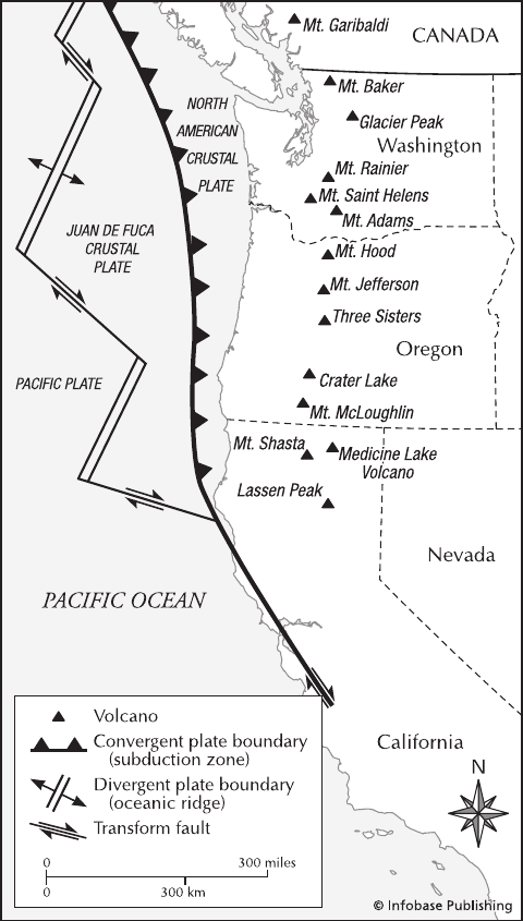
Juan de Fuca crustal plate A small plate of Earth’s
crust compared to the adjacent Pacific and North Ameri-
can crustal plates, and Juan de Fuca plate is nonetheless
important to the United States and Canada because its
ongoing collision with North America has created the Cas-
cadia Subduction Zone. This structure is the source of
seismic and volcanic activity affecting the Canadian province
of British Columbia and the states of Washington and
Oregon in the northwest United States as well as parts of
northern California. Subduction and consequent melting
of the descending crustal plate are thought to have generated
© Infobase Publishing
Map of the Japan region showing the plate geometry as well as the major
volcanoes and several cities that have experienced major earthquakes
128 Jawa
the magma that formed the volcanoes of the Cascade Moun-
tains, including Mount Hood, Mount Saint Helens, Mount
Rainier, and Mazama. The magma involved in eruptions of
these volcanoes has been rich in dissolved gases, as a result
of water-rich sediments being subducted along with the Juan
de Fuca plate. The water thus drawn into Earth’s interior
rises back to the surface dissolved in molten rock, generat-
ing highly explosive eruptions such as that of Mount Saint
Helens in 1980.
Although there is abundant evidence of volcanism con-
nected with the Juan de Fuca plate, there is no history of
highly destructive earthquakes such as those recorded fre-
quently in California. The reason for this relative absence
of strong earthquakes along the Cascadia subduction zone
is uncertain, but it has been suggested that the descend-
ing Juan de Fuca plate merely “slides” smoothly on its way
downward, without such powerful disturbances as threaten
portions of California. It is worth noting, however, that the
United States government considers the coast of the Pacific
Northwest an area of high earthquake potential and has
warned that a powerful earthquake remains a district possi-
bility for the future.
The Juan de Fuca crustal plate adjoins a subduction zone off the Pacific
Northwest coast of the United States. Also shown are the volcanoes of
the Cascade Range.
Juan de Fuca crustal plate 129
131
Kagoshima Bay See Sakurajima.
Kakuto caldera, Japan Located close to the Aira and
Kikai calderas, Kakuto caldera is about six by nine
miles (9.6 by 14.4 km) wide and is situated northwest of
Kirishima volcano. geothermal fields are situated nearby.
Although there have been no eruptions in Kakuto caldera
itself within historical times, Kirishima has a record of doz-
ens of explosive and phreatic eruptions dating back to the
eighth century a.d.
Activity at Kirishima and seismic activity at Kakuto
appear to be interrelated. In 1913–14, several earthquake
swarms at Kakuto were followed by minor eruptions at
Kirishima at about the same time as a major eruption of
nearby Sakurajima (although there may have been no con-
nection between eruptions at the two sites). This activity
coincided closely with a strong earthquake about 60 miles
(97 km) to the east. Earthquake swarms were noted again in
the caldera in 1915, but Kirishima did not erupt this time.
Several minor volcanic events in 1923, 1934, and 1936 did
not accompany earthquake activity in the caldera. Likewise, a
phreatic eruption in 1959 was preceded by only slight earth-
quake activity or none at all. Earthquake swarms occurred
after this eruption.
In 1961, a strong earthquake about 60 miles (97 km)
east of Kirishima preceded earthquake swarms in the vicin-
ity of the caldera. Earthquake activity, some of it moderately
strong, occurred between 1966 and 1969. Data collected
between 1967 and 1969 indicate perhaps a couple of feet
of uplift to the west, or possibly a comparable amount of
subsidence to the east. A minor phreatic eruption without
any outstanding seismic precursors occurred at a hot spring
at the base of Kirishima in 1971. An earthquake swarm
took place in the area later that year. fumaroles showed
increased activity in the early 1970s near Kirishima. Consid-
erable earthquake activity continued from 1974 to 1979.
In the winter of 1978–79, a small flow of sulfur, sev-
eral inches wide and about 150 feet (45 m) long, is thought
to have occurred. Between 1980 and 1983, fumaroles became
more active, another small sulfur flow occurred, and a pit
inside one crater at Kirishima cast out material resembling
tar. The most recent eruption of Kirishima was in 1992.
Kamchatka Peninsula Russia The Kamchatka Penin-
sula, on the east shore of Russia, is a magmatic arc in the
“Ring of Fire” around the Pacific Ocean basin. It con-
nects the Kuril and Aleutian Island arcs, but it is on a
peninsula of continental crust. The subduction zone at
Kamchatka involves the Pacific plate to the east being driven
beneath the Eurasian crustal plate to the west. The mar-
gin is relatively straight between the Kurils and Kamchatka,
but takes a nearly right angle turn at the boundary with the
Aleutian Islands. The surrounding landmasses may control
the shape of this bend, but it is also at the point where the
Emperor Seamounts are being subducted into the Kuril-
Kamchatka-Aleutian trench. The eastern margin of Kam-
chatka is quite mountainous, but there is a fault-controlled
valley down the middle of the island and parallel to the
trench. Much of the seismic and volcanic activity is con-
trolled by these faults.
Kamchatka is noted for its typical subduction zone vol-
canic activity, notably the eruption of Bezymianny in 1955
that closely resembled Mount Saint Helens. Kliuchevskoi
is another very active volcano that has made itself an avia-
tion hazard by spewing heavy eruption columns high into
the atmosphere on a regular basis. Other important volca-
noes of Kamchatka include Gorely, Karymsky, Koryak-
sky, Krasheninnikov, Kronotzky, Opala, Sheveluch,
and Toblachik among many others. Several of these volca-
noes are quite active. Most of the volcanoes are so remote
that there is very little information about their eruptive
histories.
Kamchatka is also seismically active. The faults bound-
ing the central valley produce regular moderate to strong
earthquakes. The Benioff zone on the downgoing Pacific
plate also produces regular deep earthquakes. Again,
K