Gates A.E., Ritchie D. Encyclopedia of Earthquakes and Volcanoes
Подождите немного. Документ загружается.

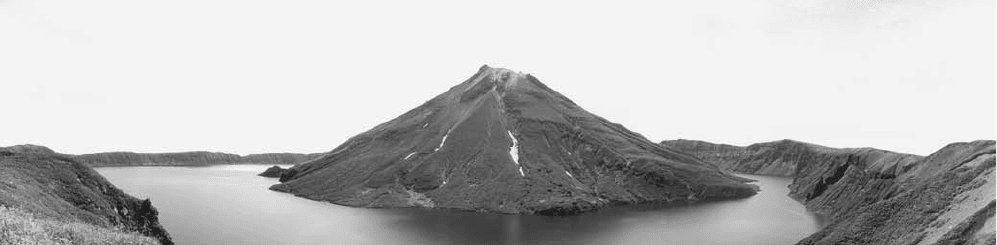
Kutcharo caldera, Japan The Kutcharo caldera is located
in northern Japan near the southern end of the volcanic Kuril
Islands. Kutcharo Lake now occupies much of the caldera.
The island stratovolcano Nakajima stands in the western
portion of the lake. To the southeast of the lake is Atosanu-
puri, a stratovolcano with an associated set of domes. The vol-
cano Mashu¯, which has a crater lake similar to the one found
at Crater Lake in Oregon, is located to the east of Atosa-
nupuri, a stratovolcano on the rim of the Kutcharo caldera.
Mashu¯ is thought to have erupted most recently some 1,030
years ago. Although no eruptions have occurred in the area
of Kutcharo caldera in recent decades, there has been consid-
erable seismic activity, and the caldera has been studied as a
possible indicator of major tectonic earthquakes.
Kverkfjöll volcano and caldera, Iceland The Kverkfjöll
volcano has a history of possible subglacial eruptions dat-
ing from the 17th century. Confirming these eruptions has
been difficult, however, and the principal evidence for them
appears to be floods of water. Two calderas at Kverkfjöll
are believed to lie under the ice.
Kwangtung earthquake, China On February 13, 1918, at
6:07 a.m., a destructive earthquake occurred in Kwangtung,
China, in the Kwangtung region about 180 miles (300 km)
from Hong Kong. The magnitude of the event was estimated
at 7.3 on the Richter scale.
Normally, the Kwangtung area is outside of the danger
zone for the damaging earthquakes for which China is infa-
mous. It is at an intracontinental location with minimal seis-
mic activity. The city was relatively unprepared for the 1918
earthquake. It was for this reason that it was so deadly. The
death toll for this event was 10,000 people, and there were
tens of thousands of injuries.
K-wave A p-wave traveling in the outer core of Earth.
The Kuril Islands contain some of the best-formed stratovolcanoes in the world. Here a resurgent volcano sits in the lake of a flooded collapsed
caldera. (Courtesy of NOAA)
142 Kutcharo
lahar In general terms, a volcanic mudflow. A lahar
is made up of water-saturated pyroclastic material that
moves down the side of a volcano and floods the country-
side. A common occurrence of lahars is that the hot ash of a
volcano erupts onto an ice cap and melts it. The meltwater
mixes with the hot ash to form a boiling hot slurry. It then
flows down the slopes and into the valleys below and floods
them. Lahars cause significant death and destruction during
eruptions. The eruption of Mount Saint Helens produced
very impressive lahars.
An interesting feature of lahars is exemplified by Mount
Pinatubo in the Philippines. The eruption of Mount Pina-
tubo took place in 1991 and it was a very strong eruption
(VEI = 5). The main cause of death was not the volcano but a
typhoon that struck two days later and swept up the still-hot
ash into boiling hot mudflows. In fact, the deeper ash is still
hot enough nine years later that if another typhoon strikes,
erosion will cut into it and again produce a boiling mudflow.
Because such occurrences are unrelated to volcanic activity,
they should be considered mudflows rather than lahars.
Laki fissure zone, Iceland A massive eruption of the
Laki fissure zone in 1783 was accompanied by the largest
release of lava (calculated at 3.5 cubic miles [14.731 km
3
])
in recorded history. It covered an area of 218 square miles
(565 km
2
). At peak eruption, lava poured from the fissures
at a rate of 295,000 cubic feet (8,600 m
3
) per second. The
Amazon River is the fastest-flowing river in the world, and it
flows 340,000 cubic feet (10,000 m
3
) per second. The erup-
tion also released gases that contaminated grass in Iceland
and caused the death of hundreds of thousands of livestock.
Some 9,000 residents of Iceland, or about 25% of the popu-
lation at the time, died in a famine that followed the erup-
tion. Apparently the particulates released during this eruption
remained in suspension over Iceland and portions of northern
Europe for months after the eruption, resulting in a peculiar
haze that was compared to fog.
Lamington, Mount Papua New Guinea The site of one
of the most violent eruptions of the 20th century, Mount
Lamington is located in the eastern portion of Papua New
Guinea, near the communities of Buna and Popondetta,
approximately 25 miles (40 km) from the coast. The moun-
tain rises almost 6,000 feet (1,830 m) above sea level and has
a deep crater from which a river flows. A large portion of
the mountain appears to have been laid down by mudflows
and
NUÉE ARDENTEs. The powerful eruption (VEI = 5) of
1951 at Mount Lamington took many observers by surprise
because the volcano had been dormant as it had no other
historical activity to that point. Preliminary activity at the
volcano either was not interpreted as eruptive or simply went
unobserved. On January 15, 1951, landslides were noted
on the crater walls. Vapor emanated from the crater for the
next two days, and earthquake swarms affected the sur-
rounding area. The volcano’s gas output increased greatly
on January 18, and ash came from the mountain as well.
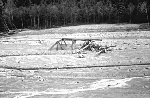
Mudflow/lahar from the Mount Saint Helens eruption, May 18, 1980. The
mudflow came down a river valley and destroyed a bridge. It filled the old
river with mud. (Courtesy of the USGS)
L
143
Underground noises intensified as the emissions increased.
Earthquakes occurred with increasing frequency until they
became virtually nonstop. Early on the morning of January
19, a dazzling display of electrical phenomena took place.
After daybreak, the top of the cone was seen to be covered
with ash. On January 20, a great ash cloud rose to an altitude
of 5 miles (8 km) or higher. At 10:40 a.m. on January 21, a
giant cloud rose from the volcano and reached an altitude of
20,000 feet (6,000 m) in less than a half-hour.
The base of the cloud spread out rapidly over the adja-
cent land. The nuée ardente from this stage of the eruption
caused the greatest devastation to the north of the volcano
and is thought to have moved at an average speed of about
60 miles (97 km) per hour, though probably much faster in
certain areas. Phenomena similar to tornadoes are believed to
have accompanied the nuée ardente and produced dramatic
disparities in effects from one place to another. The nuée
ardente laid waste some 68 square miles (176 km
2
) of land
and killed almost 3,000 people in the vicinity on January
21. (Total number of deaths attributed to this eruption were
6,000.) Heated dust laden with steam probably accounted
for most of the deaths. Many survivors suffered severe burns.
The stiff condition of bodies found after the passage of the
nuée ardente indicate the heat from the cloud was intense.
Two zones of destruction were observed in the area affected
by the nuée ardente. Close to the crater, destruction was vir-
tually total because of the combination of intense heat and
high velocity; in this zone, some trees and buildings were car-
ried away completely. Close to the crater, the nuée ardente
produced a powerful scouring action that effectively ground
away everything in its path, down to the level of the abraded
soil. A comparatively small outer zone was affected more
by heat than by blast. Valleys around the volcano were filled
with hot ash that retained its heat for months after the Janu-
ary 21 eruption. Wood buried under this hot ash would catch
fire when exposed to the air weeks later.
At the time of the catastrophic eruption of January 21,
Mount Lamington, whose noises had been intermittent up to
this time, began to give off a steady roar that was audible on
New Britain, 200 miles (322 km) to the north. A few minutes
before 9 p.m., another strong eruption occurred. Activity sub-
sided for the following three days and then began again on
January 25. Further explosive events occurred in February and
March. Less powerful eruptions followed on an intermittent
basis. Dome formation began in the crater of Mount Lam-
ington soon after the January 21 eruption. In about a month
and a half, a dome more than 1,000 feet (305 m) high arose,
sometimes at an average rate of more than four feet (1.2 m)
per hour. An eruption on March 5 demolished this dome, but
it grew back higher than before by the middle of May. Even-
tually, the dome reached a height of approximately 1,800 feet
(549 m) above the floor of the crater. This eruptive period
lasted until 1956. The devastated area recovered quickly after
the 1951–56 eruptions, and by the mid-1960s, vegetation
reportedly had regrown completely so that the area affected
by the nuée ardente looked identical to adjacent land.
Land of the Giant Craters Tanzania Located on the edge
of the Great Rift Valley near the volcano Ngorongoro,
the Land of the Giant Craters is a plateau made up of ejecta
from nearby volcanoes.
landslide Many different kinds of earth movement are
described by the comprehensive term landslide, which refers
in general to a down-slope movement of unconsolidated
material under the influence of gravity. Landslides may
include mudflows, rockfalls, avalanches, and numerous
other phenomena. Landslides are commonly associated with
earthquakes, especially in mountainous regions, although
landslides may occur in relatively flat country when condi-
tions allow mass movement of unconsolidated material down
a gentle slope. Landslides may also occur in volcanoes. The
largest landslide ever observed began the 1980 eruption of
Mount Saint Helens. Much of the death and destruction
in earthquakes is caused by fast-moving landslides that drop
from elevated areas.
In the 1964 Good Friday earthquake of Alaska,
for example, numerous buildings on a plain (flatland) near
Anchorage were destroyed by landslides when the earthquake
allowed material at and near the surface to slide along under-
lying wet clay. In some locations, the landslides produced by
this earthquake were rotational, meaning that the ground sur-
face tilted as blocks of Earth rotated while sliding downslope.
Elsewhere, nonrotational movement was observed, as Earth
broke into an up-and-down pattern of horsts, or relatively
elevated blocks, and grabens, or depressed areas. In one
widely publicized case, a school building toppled off the edge
of a horst and landed upside-down in the adjacent graben.
Another Alaskan earthquake, in 1958, generated a landslide
that caused a spectacular and highly destructive wave to form
in Lituya Bay. This wave reached more than 1,700 feet (518
m) up the side of the valley where the slide occurred. (The
Empire State Building in New York City, by comparison, is
only about 1,000 feet (305 m) high.)
The Columbia River gorge between Oregon and Wash-
ington shows evidence of tremendous landslides within
recent geologic time, such as the Bonneville Slide, thought
to have occurred about a.d. 1100 and to have involved
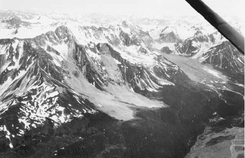
Scars in the mountains and lighter-colored rock avalanche deposits at the
foot of the mountains show the general geometry of landslides in Alaska
as the result of the 1964 Good Friday earthquake. (Courtesy of the USGS)
144 Land of the Giant Craters
almost a half cubic mile (0.13 km
3
) of rock, damming the
Columbia River temporarily. In the greater Los Angeles area,
potential landslides pose a special problem because they stand
to block important highways following a major earthquake
there in the future, thereby isolating the region.
Landslides may occur either on dry land or on undersea
slopes bearing unconsolidated material. Certain submarine
landslides are known as turbidity currents. One famous
turbidity current was generated by the Grand Banks earth-
quake off Newfoundland in 1929 and severed a number of
submarine telegraph cables on the bottom of the Atlantic
Ocean. Later, the recorded times of cable breaks allowed the
maximum velocity of the turbidity current to be calculated at
some 55 knots.
landslide hazard reduction There are numerous areas
that are plagued by landslides. Geologists map these areas
to determine their landslide potential on a fine scale. The
areas with the highest landslide potential are recommended
for landslide hazard reduction. There are numerous methods
to reduce the landslide risk depending upon the severity of the
hazard posed. There are simple methods such as planting veg-
etation to hold the slope together or digging drainage ditches
to reduce the fluid pressure. More involved methods involve
slope reduction and even the building of retaining walls or
the cementing of a slope. In some instances, more than one
method may be required to address the problem. Each of
these methods is considered to be landslide hazard reduction,
and some towns and cities have long-term programs for this
practice.
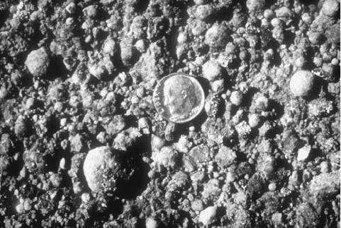
lapilli Pieces of pyroclastic material, ejecta, shot out of
a volcano and deposited and ranging in diameter from about
0.08 inches (2 mm) to about 2.5 inches (64 mm).
Larderello hydrothermal activity area, Italy Larderello,
a hydrothermal activity area, is noted for its geother-
mal power facility, which began to generate electricity for a
chemical plant on the site in 1904 and, by World War II, was
producing almost 1,000 million kilowatt-hours of electricity
each year. The power facilities at Larderello were wrecked by
German forces in 1945 but were rebuilt. Larderello also has
been the location of a large and profitable chemical industry
that began by extracting borax from natural steam. Count
Francesco Larderel is credited with the idea of using energy
from the natural steam at the site to concentrate boric acid
solutions. The hydrothermal activity at Larderello appears to
stem from magma underlying an area of several dozen square
miles.
Lassen Peak California, United States Located in north-
ern California just south of Medicine Lake volcano and
Mount Shasta, Lassen Peak is the southernmost volcano in
the Cascade Range. Lassen Peak stands some 14,500 feet
(4,460 m) high and was considered the most recently active
volcano in the 48 contiguous United States until the eruption
of Mount Saint Helens in 1980. Lassen Peak includes three
active volcanoes and exhibits hydrothermal phenomena
such as steam vents and hot springs. The eruption of Las-
sen Peak in 1914 began without warning and commenced
with minor releases of ash. Continuing eruptive activity over
about a year cast blocks of rock from the crater. Explosive
eruptions in the spring of 1915 were accompanied by emis-
sions of lava, and one eruption on May 22 deposited tephra
in Nevada, some 200 miles (322 km) east of the volcano.
lahars descended along the flanks of the mountain, and on
May 22 a
NUÉE ARDENTE gave rise to a large mudflow that
required the prompt evacuation of a valley near the moun-
tain, with no reported deaths. Further eruptions, though
less intense, continued through 1917. Its last eruption was
in 1921. Volcanic formations include Cinder Cone, which
erupted in the 1850s and expelled both ash and lava; and the
sulphur Works, where hydrogen sulfide escapes from hot
springs and steam vents.
Lassen Peak differs from the other volcanoes of the Cas-
cade Range in that it is not a stratovolcano but rather a
very large dome surrounded on the south and west sides by
smaller domes. A few miles south of Lassen Peak, one finds
the remains of a huge stratovolcano, known as Brokeoff vol-
cano, that has a diameter up to 15 miles (24 km) at its base
and is believed to have stood some 11,000 feet (3,353 m) tall.
The collapse of Brokeoff volcano created a caldera more
than two miles (3 km) wide and left a dramatic fault scarp
visible today at Brokeoff Mountain. Lava from Brokeoff
volcano now mostly surrounds Lassen Peak, and these vast
outpourings of lava from the ancient volcano may have been
partly responsible for its subsequent collapse.
lateral blast An effect sometimes seen in explosive
eruptions of volcanoes, a lateral blast occurs when a vol-
cano explodes sideways, directing the force of the explo-
sion through a side vent and down the volcano in a
NUÉE
ARDENTE rather than vertically in a summit eruption. The
nuée ardente spreads over the landscape and is probably the
most destructive type of event. The reason that a lateral blast
occurs is that the main vent that leads to the summit cal-
dera clogs up. Very sticky magma like rhyolite, dacite,
and some andesite tend to cause clogs especially when there
Lapilli are moderate-size ejecta between ash- and bomb-size volcanic
fragments. The dime is shown for scale. (Courtesy of the USGS)
lateral blast 145
are many crystallized minerals in them. If it does, pressure
builds up inside the volcano. Eventually a fracture will
open in a weak spot in the side of the volcano through which
the pressure is released in a very strong explosion. This phe-
nomenon was observed in the 1980 eruption of Mount Saint
Helens, when the north flank of the volcano disintegrated
and released pressure from inside the mountain, resulting in
a blast that sent low-level clouds rushing over the adjacent
terrain, destroying large amounts of timber. The archetypal
eruption that produced a lateral blast was Mount Pelée in
1902. A “Pelean eruption” is the most powerful type of vol-
canic eruption.
lateral spread and flow In mass wasting, many forms
of landslides occur on gentle slopes, and the moving soil
mass exhibits fluidlike behavior as it descends, spreading out
laterally at the base of the hill. These terms, lateral spread
and flow, refer to the movement of such masses.
latite An intermediate volcanic rock named for Latium,
Italy. It is porphyritic (mixed large and small grain sizes)
with large grains of plagioclase and K-spar in a glassy
matrix. It is relatively quartz-poor. Compositionally, it fits
between andesite and trachyte.
lava Lava is molten rock that flows out onto Earth’s sur-
face. Molten rock at depth is called magma. The difference
between magma and lava is (1) that lava is at the surface
and (2) that all of the volatiles including water, sulfur
compounds, and carbon dioxide are released in the erup-
tion. Therefore, magma contains all of the volatiles, and lava
does not. The word lava appears to be derived from the Ital-
ian word lavare, “to wash away.” The Italian verb is not
restricted to the action of lava but also may refer to a flood
of water or even to a moving crowd of people. Over the cen-
turies, “lava” has been used to refer to a variety of volcanic
phenomena, including mudflows. Now, however, its use is
generally confined to fluid, molten rock reaching Earth’s sur-
face and to the formations produced by such rock during vol-
canic eruptions.
Where lava solidifies after flowing for some distance, the
resulting deposit is called a lava flow. Lava flows on dry
land may form aa, characterized by a broken, sharp-edged
surface, or pahoehoe, which has a peculiar ropy texture.
Submarine lavas consist of rounded masses called pillow
lava, formed as molten rock comes into contact with cool
seawater. Lava flows show a wide range of grain sizes,
depending on their rate of cooling and how long they spend
in the magma chamber. The longer in the chamber and the
slower the cooling, the larger the grain size. Open spaces or
vesicles may form in lava that has a high concentration of
dissolved gases. An example of such vesicular volcanic rock
is pumice, which is light enough to float on water. Another
widespread, vesicular volcanic rock is scoria. Some lava
flows include xenoliths, foreign material picked up and car-
ried along by the lava. lava tubes, hollow tunnels within a
lava flow, form as surrounding lava cools and molten rock
in the tube drains away. In some cases, lava tubes are large
enough to accommodate humans. spatter cones, small vol-
canic “mountains” several feet high, may form out of lava
spewing from vents in the ground. One impressive phenom-
enon of some lava flows is columnar jointing, in which
solidified lava forms vertical, prismatic columns several feet
wide. Giant’s Causeway in Ireland is a spectacular example
of columnar jointing. Molds are commonplace features of
lava flows and are formed when lava surrounds an organism
such as a tree and hardens. When the tree decays and disap-
pears, the mold remains in the lava flow. ashfalls also may
produce molds by burying an animal or other organism, of
which a mold remains after the organisms body decays.
Excavations at Pompeii and Herculaneum have revealed
detailed molds of animals and humans who were killed in the
eruption of Vesuvius in a.d. 79. Plaster was poured into the
molds, providing images of the eruption’s victims.
Lavas vary in their chemical composition and are cate-
gorized according to their silica (silicon dioxide) concentra-
tion. Lavas containing 66% or more silica are called felsic
or acidic. mafic or basic lavas, at the other end of the spec-
trum, have a silica content of 52% or less. intermediate
lavas contain between 52% and 66% silica. The behavior of
lava during an eruption depends largely on its silica content.
As a rule, felsic lavas are “thicker” in character, flow with
difficulty and are involved in explosive eruptions. (The explo-
sive character of these eruptions stems from the difficulty dis-
solved gases have in escaping from the highly viscous lava. In
some situations, gas coming out of solution from magma will
accumulate and build up pressure until an explosive event
occurs. Well-known examples of such eruptions are those of
Mount Saint Helens in 1980 and Bezymianny in 1952.)
Slow-flowing, felsic lavas containing about 74% silica are
called rhyolites and are often pink or gray in color. rhyolite
is commonly found in lava domes. Mafic lavas flow more
readily than felsic lavas and allow gases to escape easily, thus
avoiding explosions.
Mafic rocks are also darker than felsic lavas. The vol-
canoes of the Hawaiian Islands are familiar examples of
volcanoes that emit mafic lava, basalt.
In between these two
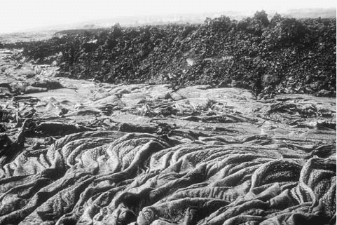
The foreground is a rope-textured pahoehoe lava, and the background is
an encroaching slow-moving aa lava flow in Hawaii. (Courtesy of the
USGS)
146 lateral spread and flow
extremes of chemical composition are the intermediate lavas,
known as andesites, named for the Andes Mountains.
Besides silica, lava may contain many chemical com-
ponents, including aluminum, calcium, iron, magnesium,
potassium, and sodium, depending upon the rock. Felsic
lavas typically are rich in alkalis (potassium and sodium)
and poor in calcium, iron, and magnesium. These propor-
tions are reversed in basic lavas. Lava emanating from a
volcano may differ in composition from one time to another
during the course of eruption. Also, a single volcano may
emit lavas of different compositions from one eruption to
another. These differences are thought to involve a process
known as fractionation and assimilation. Fraction-
ation refers to the dividing up of magma, or molten rock
still underground, by removing components through crys-
tallization and settling. Initially, the composition of the
magma is largely homogeneous. As heavier components of
the magma are used to make mafic minerals during higher
temperature crystallization, these heavier minerals settle
out of solution. The crystallization sequence generally fol-
lows Bowens Reaction Series. Therefore, the character of
the remaining magma changes accordingly. The remaining
liquid becomes more and more felsic. Assimilation involves
the removal, melting, and mixing of country rock from
the walls of a magma chamber underground. The mix-
ing of different kinds of magma that have intruded into a
single magma chamber is another source of compositional
change.
There is a distinct difference between lavas of the con-
tinents and lavas of the ocean floor. Continental lavas tend
to have higher concentrations of silicon and aluminum.
When basaltic magma from the mantle rises toward the
surface and passes through continental rocks, the molten
rock takes on some characteristics of the continental crust
through the process of assimilation. The result is a more
intermediate lava or a “contaminated” lava. Earth’s surface
is covered in some places by huge and spectacular outpour-
ings of basaltic lava. These deposits are known as flood
basalts and may cover thousands of square miles. In the
northwest United States, flood basalts have covered large
areas of the states of Idaho, Oregon, and Washington.
Great flood basalts are also found in the Deccan plateau of
India, Pihrana of South America, and Karoo of Africa.
Flood basalts may originate as fissure flows, when cracks in
Earth’s crust disgorge huge quantities of highly fluid, fast-
flowing lava. Such floods of molten rock may travel many
miles in a single day.
Lava flows can cause great destruction when an eruption
occurs in or near a heavily populated area. Such incidents are
commonplace in southern Europe and along the Pacific rim,
where large communities exist near active volcanoes. Espe-
cially dangerous in this respect are volcanoes such as Vesu-
vius in Italy and Mount Etna in Sicily. There have been
numerous attempts to divert lava flows before they reach
populated areas, but these efforts have met with varying
degrees of success.
Lava flows tend to cool gradually because rock is an
inefficient conductor of heat. When a relatively cool layer
of solidified lava forms on the surface of a lava flow, that
layer may provide insulation that allows the lava below to
remain in a fluid state for months or even years. Many fac-
tors may affect the rate of cooling of a lava flow, however,
such as rainfall, cooling through cracks, and even flowing
into the sea.
lava dome This structure is made up of extremely viscous
lava that moves upward through the vent of a volcano and
forms a domed, craggy surface. They are therefore common
in rhyolite, dacite, and some andesite volcanoes. Lava-
dome formation commonly follows an explosive eruption
of a volcano, when gas-rich magma has been expelled and
thicker, more viscous lava flows out. A lava dome is com-
monly surrounded by debris dislodged from the surface of the
dome during its growth.
The lava domes formed at Mount Saint Helens in
Washington State have received extensive study. Out of
five episodes of explosive activity at Mount Saint Helens
in 1980 and 1981, a lava dome formed in three of these
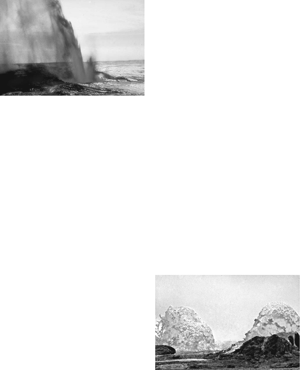
Fountain and lava drain back into the volcanic vent at the end of
the Mauna Ulu phase of the Kilauea eruption, Hawaii, October 20,
1969. The lava drains back into the vent after the eruption begins to
subside. (Courtesy of NOAA)
Two lava dome fountains during the Mauna Ulu of Kilauea eruption on
June 29, 1970 (Courtesy of NOAA)
lava dome 147
episodes after explosive activity diminished. The first dome
grew for at least a week after an explosive eruption on June
12, 1980, and eventually grew to be more than 1,000 feet
(305 m) in diameter and some 150 feet (46 m) high. Part
of this dome was destroyed during an explosive eruption
in July. A new and smaller dome formed following another
explosive eruption on August 7. An eruption in October
was followed by the formation of a third dome. Analyses
of samples from the dome indicated the magma was very
low in sulfur and oxygen, possibly because gases had
escaped from the magma before the dome formed. Study
of the dome also made possible an estimate of the thermal
energy yield of the Mount Saint Helens eruptions of May
through October 1980. This estimate puts these eruptions
in roughly the same range of energy yield as the eruptions
of Hekla in 1970 and Mauna Loa in 1950. Evidence of
lava domes on the planet Venus was returned by the U.S.
Magellan space probe in 1990. Radar images of a portion
of the surface of Venus showed a chain of seven domelike
structures, each about 15 miles (24 km) wide and as high
as about 2,200 feet (671 m).
lava field An area that is covered by lava flows, forming a
field of them. Lava fields are common around active volcanoes.
lava flow A single event of flowing lava. Always the result
of an eruption, but an eruption does not guarantee a lava
flow. A lava flow must include molten rock, so pyroclastic
eruptions or phreatic eruptions do not define a lava flow.
In basalt volcanoes, like those in Hawaii, nearly every
eruption includes a lava flow. In intermediate and felsic
volcanoes, most eruptions do not include lava flows. In the
Hawaiian eruptions, the lava flows quickly, and it is very
hot (1,400°C). However, it is so predictable that they rarely
inflict casualties. In felsic and intermediate volcanoes, if they
are to the point of flowing lava, evacuation should have been
finished long before.
lava tube A tube or cavity within a lava flow. As a lava
flow moves down the slope of the volcano, the top cools and
hardens. There is still liquid lava underneath that can flow
out. Therefore, there is a gap underneath the crust where
the lava flowed out. The lava tube is the resulting cavelike
feature. Lava tubes are common in basalt volcanoes. The
lava must have low enough viscosity to be able to flow out
from under the crust. Sticky, high-viscosity lava will not
flow out. There are abundant lava tubes in the Hawaiian
volcanic fields. The roof of these cavelike structures can col-
lapse leaving a hole or skylight. People can climb down into
the lava tubes through the skylights.
left-lateral fault A strike-slip fault in which the block
on the opposite side of the fault from where you are standing
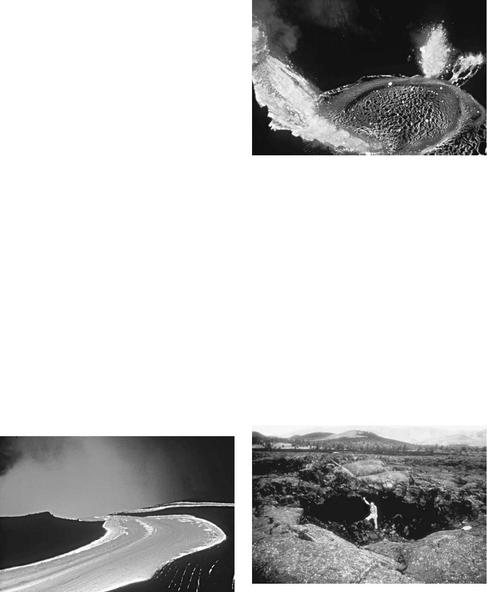
A ribbonlike lava flow from the Kilauea east rift, Hawaii, on November 27,
1989. These rivers of lava can flow tens of miles per hour on steep slopes
but are slower on flat areas. (Courtesy of NASA)
Lava cascades falling into a lava lake in Pauhi’s west pit in the Mauna
Ulu eruptions at Kilauea, Hawaii, November 11, 1973. The black crust
cracks, revealing the glowing lava underneath. The dark ring represents
a change in the filling of the lava lake. (Courtesy of NOAA)
Skylight in a lava tube near Kalapana, Hawaii, on February 2, 1989. The
lava tube formed when a crust developed on a flow. The liquid lava
flowed out, leaving the cavelike lava tube. The skylight is formed when
the ceiling above the lava tube collapses. (Courtesy of NOAA)
148 lava field
moves to your left. They are also known as sinistral strike-
slip faults.
Lehmann discontinuity There is a sharp change in seismic
velocity deep within the Earth. This boundary was named the
Lehmann discontinuity after the first woman geophysicist,
Dr. Inge Lehmann from Denmark. It is interpreted to repre-
sent the boundary between the inner core and outer core
of the Earth.
lherzolite A type of peridotite that is dominantly com-
posed of both orthopyroxene and clinopyroxene. They are
ultramafic, plutonic rocks. Lherzolites have been found
in fragments of mantle xenoliths. It is thought that much of
the mantle is composed of lherzolite.
Libya The country lies along the Mediterranean Sea
and as such is at the northern margin of the African plate.
Interactions between the African and European plates in this
area make northern Libya seismically active. Early records
of earthquakes date back to Roman times, when two dev-
astating earthquakes destroyed most of Cyrene. The earth-
quakes were dated at a.d. 262 and 365 and were said to have
killed tens of thousands of people each, causing utter chaos
in the Roman Empire. The Middle Ages also had reports
of large earthquakes that caused great destruction. Nota-
bly, the earthquake of a.d. 704 in Sabha, southern Libya,
which destroyed several towns and a village. The first well-
documented disaster was the earthquake of a.d. 1183, which
destroyed Tripoli and reportedly caused the deaths of some
20,000 people. Tripoli experienced several less intense trem-
ors in 1803, 1811, and 1903. One of the major seismically
active structures in Libya is called the Hun Graben. On April
19, 1935, an earthquake of Richter magnitude 7.1 struck
the area and was followed by numerous aftershocks, includ-
ing one of magnitude 6.5 and another 6.0. In 1941, it was
hit by another earthquake of magnitude 5.6. The Gulf of Sirt
is another active area, with an earthquake of magnitude 5.6
in 1939. A recent example of Libyan seismicity occurred on
February 21, 1963, when a large earthquake struck the vil-
lage of Al Maraj. The quake measured a 5.3 on the Richter
scale and was followed by several aftershocks. The death toll
was 300–500 people, and some 12,000 were left homeless.
Lipari Islands Tyrrhenian Sea, Italy Located near the tip
of the Italian Peninsula, just north of the island of Sicily, the
Lipari Islands (also known as the Aeolian Islands) are a clus-
ter of volcanic islands, of which the most famous are Lipari,
which contains Campo Bianco, Stromboli, and Vulcano.
Other islands in the group include Alicudi, Basiluzzo, Filicudi,
Panaria, and Salina. The volcanoes are seen as part of a line
of volcanic mountains extending along the west shore of the
Italian Peninsula, parallel to the Apennines.
liquefaction One of the principal causes of property dam-
age from earthquakes, liquefaction occurs when earthquake
vibrations make soil lose its cohesion and behave tem-
porarily as a liquid, largely as the result of the addition of
groundwater that is forced upward from depth. Structures
built upon soil undergoing liquefaction may suffer severe
damage. For this reason, the character of underlying material
is, or should be, a major safety consideration when planning
construction in areas known for frequent and/or energetic
earthquake activity. Liquefaction commonly takes place dur-
ing earthquakes in poorly consolidated soil where ground-
water exists close to the surface. These conditions prevail in
many areas subject to frequent, strong earthquake activity.
Water between particles of soil is known as pore water, and
the pressure of pore water rises with the passage of waves
from an earthquake because groundwater is driven toward
the ground surface and adds to this pore moisture. The rapid
addition of large amounts of groundwater makes the ordinar-
ily solid soil assume a liquid condition temporarily. It takes
on the consistency of quicksand.
Damage may result in several ways. When liquefaction
occurs on slopes as small as perhaps 3°, large masses of soil
may flow downslope, either in liquefied form or as large blocks
of still-cohesive soil sliding on an underlying, liquefied layer of
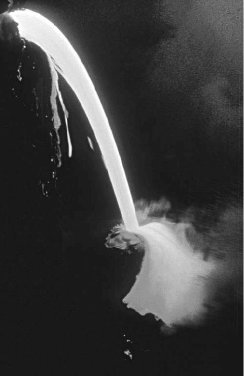
A lava tube is made because a solidified crust develops on top of the flow
while the liquid lava drains from underneath. This photo shows the lava
draining and pouring into the Pacific Ocean. The flow is from Kilauea’s
East Rift on November 27, 1989. (Courtesy of NOAA)
liquefaction 149
soil. In some cases, vast quantities of material are transported
over distances of several miles. Lateral spread is another source
of property damage from liquefaction. In this phenomenon,
blocks of soil at the surface slide sideways because of liquefac-
tion of an underlying layer. Lateral spread may not be as dra-
matic as flow failure and may result in displacements of only
a few feet. Even such seemingly small displacements can be
highly destructive, especially if they sever underground water
lines required to fight postearthquake fires in urban areas.
Ground oscillation occurs when liquefaction of subsurface lay-
ers of soil allows blocks of soil on the surface to oscillate and
display a variety of earthquake-related effects, such as wavelike
rippling and fissures. This kind of ground motion may cause
severe damage to buildings, which as a rule are not designed
and constructed to withstand strong ground oscillation.
Finally, soil simply may lose its bearing strength, or the
ability to support overlying structures. This occurs when soil
at the surface undergoes liquefaction; structures built on it
respond in a variety of ways, such as sinking or rolling over.
Multistory buildings have been known to capsize, much in
the same manner as a ship at sea, during such episodes of liq-
uefaction (see Niigata). Another effect associated with this
loss of bearing strength is the rise of buoyant underground
structures such as fuel tanks or septic tanks. In evaluating the
potential of a given locality to liquefaction, geologists must
consider susceptibility to liquefaction (that is, the character
of materials near the surface and their response to an earth-
quake) and the opportunity for liquefaction (how often the
locality is struck by earthquakes and their severity). This
determination of liquefaction potential may have to be made
on a site-by-site basis rather than a regional basis because
conditions may differ greatly from one location to another, in
some cases within a distance of feet or yards.
In general, the soils most susceptible to liquefaction have
the following characteristics: They were deposited relatively
recently; they are made of loose and generally fine sediment
(such as sand or silt) that lacks cohesion; and they contain
water that rises close to the surface. Particle-size distribution
is important because liquefaction potential tends to diminish
as particle size increases. This relation means a gravelly soil is
less likely to liquefy than a sandy or silty soil is, and deposits
of boulders or of mixed cobbles and gravel are unlikely to liq-
uefy at all. At the other extreme of particle size, clay can also
be resistant to liquefaction if hardened. The depth to ground-
water is also important because soils in which groundwa-
ter approaches to within several feet of the surface are more
susceptible to liquefaction than are soils where groundwater
remains several tens of feet below the surface. Many areas of
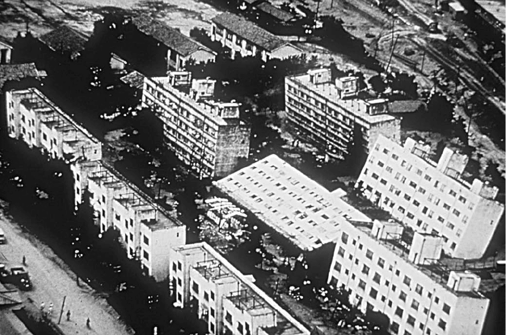
These apartment buildings in Niigata, Japan, were built to be earthquake-proof. During the June 16, 1964, earthquake of magnitude 7.4, the buildings
withstood the shaking, but liquefaction compromised the foundations, and the buildings fell over still perfectly intact. (Courtesy of NOAA)
150 liquefaction
the United States with histories of strong earthquake activity
also show all three of the aforementioned soil characteristics that
are associated with high liquefaction potential. The Mississippi
River valley; the areas around Charleston, South Carolina,
and Boston, Massachusetts; and portions of California all
exhibit the combination of silty or sandy soil, deposited recently
and containing groundwater near the surface.
Two other factors influencing the area extent and degree
of liquefaction are, of course, the magnitude and duration
of an earthquake. The more powerful an earthquake, the
more intense its associated ground motion is likely to be and
therefore the greater the danger from liquefaction of suscep-
tible soils. Proximity to the origin of an earthquake is also a
factor; a strong earthquake is likely to cause liquefaction at
greater distances than a comparatively mild one.
Lisbon earthquake, Portugal One of the most destructive
earthquakes in history, the great Lisbon earthquake may have
killed some 70,000 people. The shocks began on the morning
of November 1, 1755, All Saints’ Day, and reportedly killed
numerous worshipers in the churches of Lisbon as the build-
ings collapsed. Three shocks are believed to have struck Lis-
bon, shaking down most structures in the city. The destruction
raised large quantities of dust, which blocked sunlight and cast
the city briefly into darkness. The shocks reportedly generated
a series of tsunamis that devastated Lisbon’s waterfront. Large
numbers of refugees made their way to the waterfront, specifi-
cally to a large marble quay. Although the tsunami appears to
have spared the quay itself from destruction, one report indi-
cates that the quay subsided into the waters, leaving not a
single survivor behind nor even a trace of the vessels moored
to it. Fire following the earthquake added to destruction from
the quake itself but appears to have reduced the threat of pesti-
lence by consuming the bodies of numerous victims.
King Joseph was away from Lisbon but was in the vicin-
ity, at Belem, when the earthquake struck. He and his court
reportedly were so frightened by the shocks that they spent
the night outdoors in their carriages. The next morning, the
king returned to Lisbon to take stock of the damage and
restore order to the shattered city, which had suffered from
looting and murders in the aftermath of the earthquakes. The
royal palace had survived with its kitchens intact, and his
cooks began to prepare food for the hungry populace. The
government purchased large amounts of grain from the area
around Lisbon and distributed it at modest cost or free of
charge to the public. Hundreds of aftershocks during the
following year are said to have kept the public’s nerves on
edge, but eventually the city recovered, and a decade after the
earthquake, Lisbon had been rebuilt.
The Lisbon earthquake was felt over much of Europe; it
appears to have generated landslides in the mountains of
Portugal and to have been felt as a powerful disturbance in
Algeria and Morocco. In Morocco, a fissure is said to
have opened that sent a village of more than 8,000 residents
along the shore tumbling into the water. Tsunamis from the
Lisbon earthquake allegedly came ashore as waves more than
20 feet (6 m) high in the Lesser Antilles, on the opposite side
of the Atlantic Ocean. Strong earthquakes also hit North
Africa about the time of the Lisbon catastrophe. Water levels
in lakes in Scotland and Switzerland rose and fell by several
feet immediately after the Lisbon earthquake.
lithology In general terms, the description of rock, espe-
cially its texture (grain size and relation among the grains),
mineral components (composition), and physical character
(layering, fractures, etc.). A low-density, “foamy” volca-
nic rock such as pumice, for example, has a much different
lithology from volcanic glass, or obsidian, though they may
have the same composition.
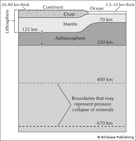
lithosphere The outer, most “rigid” layer of Earth, includ-
ing the crust and the uppermost layer of the mantle. The
lithosphere is divided into a series of plates that are able to
drift around Earth. These lithospheric plates float on the
asthenosphere, which is a soft layer in the upper mantle.
The lithosphere sits beneath the atmosphere.
See also Earth, internal structure of.
Little Sitkin volcanic island, Alaska, United States Little
Sitkin is located in the Aleutian Islands and has two cal-
deras. Eruptions were reported in 1776 and between 1828
and 1830, but little is known about these events.
littoral cone When flowing lava hits water, it hardens
almost instantly. Therefore, it becomes stiff and can pile up.
In lava flows that reach the ocean, a littoral cone forms
where the lava hits the water. These cones are typically only
five to 10 feet (1.5 to 3 m) high. Because they are in the surf
zone, they are typically eroded away quickly.
Diagram showing the layers of the shallow part of the Earth. The crust
(continent and ocean) and uppermost mantle comprise the lithosphere
that floats on the asthenosphere. The upper mantle is also shown.
littoral cone 151